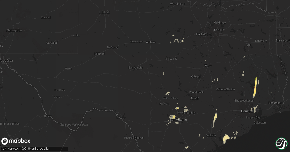
Hail Map in Texas on June 11, 2025
Get this storm
June 11 map
$229
one time, instant access
Download today. No call, no setup
Keep the $229
Bought the map and want the full workflow? Apply the entire $229 to a subscription within 7 days. None of it is wasted.
Every map, not just this one
This buys you this map. Subscription and you get every map we run, in the markets you choose from a few cities to whole states to nationwide. Plus real-time alerts the moment a storm fires.
Contact data
Name, contact info, occupancy, even credit band for addresses in the footprint. You go from where it hit to who to call.
Become the source they trust
Unlimited branding weather history reports on demand. You already have the documented answer ready for the property owner, and you are the one who showed up with it.
Property data and RoofTrace estimates
Pull up any address you have got, its value and the exact code rules for that jurisdiction, straight from One Click Code. Then RoofTrace estimates the squares, pitch, and roof value, priced the way you price.
Storm reports in Texas
Texas
| Date | Description |
|---|---|
| 06/11/20253:20 AM CDT | An ef-0 tornado with winds of 75 mph began just east of burr and produced some minor tree damage along its path as it travelled west across cr 117. An older shed also h |
| 06/11/20253:05 AM CDT | An ef-1 tornado with 100 mph winds touched down just behind some apartments northeast of wharton and travelled east across cr 166... Cr 133... And cr 129. The most exte |
| 06/11/20252:25 AM CDT | Widespread tree damage and minor damage to some metal buildings along buffalo road. |
| 06/11/20252:23 AM CDT | Microburst produced a measured wind gust of 95 mph at the palacious airport. Most damage was confined to large tree branches snapped and some minor roof damage in the a |
| 06/11/20252:23 AM CDT | Microburst produced a measured wind gust of 95 mph at the palacious airport. Most damage was confined to large tree branches snapped and some minor roof damage in the |
| 06/11/20252:22 AM CDT | A number of large tree branches down in the area. |
| 06/11/20251:06 AM CDT | Southwest hays county tornado 2 rated ef0. The track of the second tornado was estimated through a combination of information gathered by the survey team and through ra |
| 06/11/20251:04 AM CDT | Damage to trees... Windows... And roof reported. Tornadic debris signature observed on radar. |
| 06/11/20251:02 AM CDT | Southwest hays county tornado 1 rated ef0. The survey team determined that this tornado formed just east of purgatory road... South of farm to market road 32. The most |
| 06/10/202511:42 PM CDT | Estimated 60 mph wind gust and hail up to penny size. |
| 06/10/20257:56 PM CDT | A brief tornado was caught on video west of gholson. Local officials found damage to a property near mary ware dr and hamilton dr. This tornado was rated ef-0 with maxi |
All States Impacted by Hail Map on June 11, 2025
Cities Impacted by Hail Map on June 11, 2025
- Emporia, VA
- Jarratt, VA
- Capron, VA
- Yale, VA
- Courtland, VA
- Drewryville, VA
- Franklin, TX
- Crosby, TX
- Branchville, VA
- Suffolk, VA
- Saint Matthews, SC
- Sumter, SC
- Hobbsville, NC
- Gatesville, NC
- Belvidere, NC
- Silsbee, TX
- Sunbury, NC
- Corapeake, NC
- Gates, NC
- Cameron, SC
- Rock Rapids, IA
- Elloree, SC
- Elizabeth City, NC
- South Mills, NC
- George, IA
- Little Rock, IA
- Sibley, IA
- Ocheyedan, IA
- Santee, SC
- Lake Wales, FL
- Leland, NC
- Harris, IA
- Lake Park, IA
- Pelion, SC
- Summerton, SC
- Effingham, SC
- Leesville, SC
- Spirit Lake, IA
- Akron, IA
- Le Mars, IA
- Marion, SC
- Rich Square, NC
- Clewiston, FL
- New Orleans, LA
- Arabi, LA
- Florence, SC
- Harvey, LA
- Malta, ID
- Aulander, NC
- Kelford, NC
- Roxobel, NC
- Marrero, LA
- American Falls, ID
- Pocatello, ID
- Cheyenne, WY
- Tabor City, NC
- Brunsville, IA
- Batesburg, SC
- Okoboji, IA
- Estherville, IA
- Terril, IA
- Superior, IA
- Firth, ID
- Estero, FL
- Naples, FL
- Nunn, CO
- Wagener, SC
- Aiken, SC
- Carpenter, WY
- Lehigh Acres, FL
- Fort Myers, FL
- Holbrook, ID
- Wallingford, IA
- Ault, CO
- Cherokee, IA
- Aurelia, IA
- Holstein, IA
- Wimauma, FL
- Parrish, FL
- Graettinger, IA
- Ringsted, IA
- Cylinder, IA
- Fenton, IA
- Cloudcroft, NM
- Galva, IA
- Alta, IA
- Pocahontas, IA
- Saint Stephen, SC
- Bonneau, SC
- Jamestown, SC
- Nichols, SC
- Green Sea, SC
- Natchez, LA
- Emmetsburg, IA
- Fair Bluff, NC
- Saint George, SC
- North Fort Myers, FL
- Malad City, ID
- Mayhill, NM
- Punta Gorda, FL
- Moncks Corner, SC
- Pinopolis, SC
- Cerro Gordo, NC
- Clayton, ID
- Challis, ID
- Melvin, IA
- Hartley, IA
- Everly, IA
- Milford, IA
- Spencer, IA
- Fostoria, IA
- Dickens, IA
- Arnolds Park, IA
- Ruthven, IA
- Whittemore, IA
- West Bend, IA
- Lone Rock, IA
- Burt, IA
- Algona, IA
- Bladenboro, NC
- Clarkton, NC
- Rolfe, IA
- Tampa, FL
- Aberdeen, ID
- Pingree, ID
- Cape Coral, FL
- Summerville, SC
- Saint George, GA
- Wayan, ID
- Lacrosse, WA
- Lewiston, ID
- Everson, WA
- Nooksack, WA
- Marlin, WA
- Chelan, WA
- Clarkston, WA
- Waterville, WA
- White Bird, ID
- Dayton, WA
- Deming, WA
- Ritzville, WA
- Mccall, ID
- Imnaha, OR
- Asotin, WA
- Lind, WA
- Washtucna, WA
- Rockport, WA
- Cottonwood, ID
- Stanley, ID
- Yellow Pine, ID
- Orondo, WA
- Pomeroy, WA
- Riggins, ID
- Concrete, WA
- Lucile, ID
- Lynden, WA
- Entiat, WA
- Moses Lake, WA
- Anatone, WA
- Soap Lake, WA
- Lu Verne, IA
- Wesley, IA
- Bode, IA
- Bancroft, IA
- Titonka, IA
- Downey, ID
- Gilmore City, IA
- North Port, FL
- Wesley Chapel, FL
- Bradgate, IA
- Baker, LA
- Baton Rouge, LA
- Corwith, IA
- Britt, IA
- Lava Hot Springs, ID
- Autryville, NC
- Roseboro, NC
- Clinton, NC
- Salemburg, NC
- Ottosen, IA
- Folkston, GA
- Lutz, FL
- Kanawha, IA
- Clarion, IA
- Renwick, IA
- Goldfield, IA
- Hardy, IA
- Livermore, IA
- Garner, IA
- Goodell, IA
- Tererro, NM
- Humboldt, IA
- Garland, NC
- Klemme, IA
- Belmond, IA
- Wausa, NE
- Tarboro, NC
- Cross, SC
- North, SC
- Ladson, SC
- Haynesville, LA
- Ridgeville, SC
- Etna, WY
- Harleyville, SC
- Greenwell Springs, LA
- Sheffield, IA
- Rowan, IA
- Latimer, IA
- Meservey, IA
- Alexander, IA
- Hampton, IA
- Coulter, IA
- Dows, IA
- Macclesfield, NC
- Pinetops, NC
- Elm City, NC
- Wilson, NC
- Hartington, NE
- Dorchester, SC
- Galt, IA
- Alden, IA
- Iowa Falls, IA
- Bradford, IA
- Bondurant, WY
- Webster City, IA
- Eagle Grove, IA
- Vincent, IA
- Woolstock, IA
- Yuma, CO
- Williams, IA
- Blairsburg, IA
- Elsmere, NE
- Popejoy, IA
- Geneva, IA
- Ackley, IA
- Aredale, IA
- Greene, IA
- Bristow, IA
- Dumont, IA
- Chapin, IA
- Duncombe, IA
- Fountain, NC
- Haxtun, CO
- Saint Francisville, LA
- Collinston, LA
- Dougherty, IA
- Weston, WY
- Recluse, WY
- Gillette, WY
- Clarksville, IA
- Parkersburg, IA
- Kesley, IA
- Allison, IA
- Aplington, IA
- Austinville, IA
- Shell Rock, IA
- Steamboat Rock, IA
- Wellsburg, IA
- Eldora, IA
- New Roads, LA
- Wray, CO
- Mer Rouge, LA
- Bastrop, LA
- Mount Vernon, SD
- Chappell, NE
- Jackson, LA
- Ireton, IA
- Martin, SC
- Holland, IA
- New Hartford, IA
- Liberty, MS
- Maurice, IA
- Tripoli, IA
- Readlyn, IA
- Sumner, IA
- Morganza, LA
- Caddo, TX
- Ethan, SD
- Kaycee, WY
- Reinbeck, IA
- Fairbank, IA
- Douglas, WY
- Maynard, IA
- Westgate, IA
- Oelwein, IA
- Riverton, WY
- Dike, IA
- Stanley, NM
- Gladbrook, IA
- Holyoke, CO
- Garrett, WY
- Alexandria, SD
- Haigler, NE
- Saint Francis, KS
- Arriba, CO
- Hudson, IA
- Cedar Falls, IA
- Beaman, IA
- Mitchell, SD
- Traer, IA
- Lincoln, IA
- Stout, IA
- Conrad, IA
- Morrison, IA
- Grundy Center, IA
- Dunkerton, IA
- Janesville, IA
- Gilbertville, IA
- Waterloo, IA
- Waverly, IA
- Dewar, IA
- La Porte City, IA
- Jesup, IA
- Buckingham, IA
- Raymond, IA
- Evansdale, IA
- Oran, IA
- Hazleton, IA
- Stanley, IA
- Aurora, IA
- Independence, IA
- Strawberry Point, IA
- Lamont, IA
- Winthrop, IA
- Arlington, IA
- Spencer, SD
- Fayette, IA
- Hugo, CO
- Venango, NE
- Union Church, MS
- Smithville, MO
- Clutier, IA
- Dysart, IA
- Mount Auburn, IA
- Garrison, IA
- Masonville, IA
- Manchester, IA
- Dundee, IA
- Edgewood, IA
- Arthur, NE
- Moriarty, NM
- Waco, TX
- Aquilla, TX
- Crowheart, WY
- Salem, SD
- Big Springs, NE
- Trimble, MO
- Edgerton, MO
- Meadville, MS
- Rowley, IA
- Walker, IA
- Brandon, IA
- Vinton, IA
- Greeley, IA
- Doss, TX
- Estancia, NM
- Fredericksburg, TX
- Mason, TX
- Port Allen, LA
- Urbana, IA
- Center Point, IA
- Toddville, IA
- Shellsburg, IA
- Palo, IA
- Llano, TX
- Van Horne, IA
- Alburnett, IA
- Coggon, IA
- Ryan, IA
- Central City, IA
- Earlville, IA
- Grant, NE
- Bertram, TX
- Wesson, MS
- Buffalo, WY
- Whitman, NE
- Ogallala, NE
- Keystone, NE
- Paxton, NE
- Ranger, TX
- Slaughter, LA
- Ethel, LA
- Rochelle, TX
- Strawn, TX
- Riverside, OR
- Jordan Valley, OR
- Mullen, NE
- Richland Springs, TX
- Santo, TX
- Mingus, TX
- Stephenville, TX
- Boerne, TX
- Kendalia, TX
- Martin, SD
- Gordon, TX
- Adrian, OR
- Prairie City, OR
- Bergheim, TX
- Eastland, TX
- Spring Branch, TX
- Ironside, OR
- Plainfield, IA
- Seneca, NE
- Palisade, NE
- Hyannis, NE
- San Antonio, TX
- Helotes, TX
- Allen, SD
- Hayes Center, NE
- Thedford, NE
- Mico, TX
- Porcupine, SD
- Wanblee, SD
- Rio Medina, TX
- Port O'Connor, TX
- Canyon Lake, TX
- Port Lavaca, TX
- Palacios, TX
- Yoakum, TX
- Wimberley, TX
- San Marcos, TX
- Interior, SD
- Hallettsville, TX
- New Braunfels, TX
- Fischer, TX
- Weimar, TX
- Homer, LA
- Fayetteville, TX
- Hondo, TX
- Castroville, TX
- Ellinger, TX
- Lolita, TX
- Hempstead, TX
- Baytown, TX
- Calvert, TX
- Cameron, TX
- Houston, TX
- Channelview, TX
- La Coste, TX
- Wharton, TX
- Highlands, TX
- Goliad, TX
- Cleveland, TX
- Pasadena, TX
- Shepherd, TX
- Devine, TX
- Palestine, TX
- Jbsa Ft Sam Houston, TX
- Atascosa, TX
- Coldspring, TX
- Goodrich, TX
- Livingston, TX
- Bay City, TX
- Matagorda, TX
- Von Ormy, TX
- Moscow, TX
- Corrigan, TX
- Groveton, TX
- George West, TX
- Crockett, TX
- Lovelady, TX
- Dayton, TX
- Yorktown, TX


