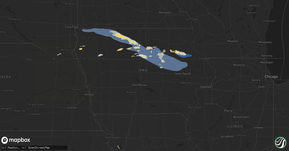
Hail Map in Iowa on June 11, 2025
Get this storm
June 11 map
$229
one time, instant access
Download today. No call, no setup
Keep the $229
Bought the map and want the full workflow? Apply the entire $229 to a subscription within 7 days. None of it is wasted.
Every map, not just this one
This buys you this map. Subscription and you get every map we run, in the markets you choose from a few cities to whole states to nationwide. Plus real-time alerts the moment a storm fires.
Contact data
Name, contact info, occupancy, even credit band for addresses in the footprint. You go from where it hit to who to call.
Become the source they trust
Unlimited branding weather history reports on demand. You already have the documented answer ready for the property owner, and you are the one who showed up with it.
Property data and RoofTrace estimates
Pull up any address you have got, its value and the exact code rules for that jurisdiction, straight from One Click Code. Then RoofTrace estimates the squares, pitch, and roof value, priced the way you price.
Storm reports in Iowa
Iowa
| Date | Description |
|---|---|
| 06/11/20256:47 PM CDT | Observed 60 mile an hour on anemometer. |
| 06/11/20256:30 PM CDT | Personal weather station. (dm |
| 06/11/20256:30 PM CDT | Personal weather station. |
| 06/11/20256:05 PM CDT | Iowa dot rwis. |
| 06/11/20255:54 PM CDT | Delayed report. Damage to an outbuilding on a farm near dows. Images found via social media. |
| 06/11/20255:39 PM CDT | Corrects previous tstm wnd dmg report from belmond. Small to large tree branches down in belmond. Ti |
| 06/11/20255:39 PM CDT | Trees down in belmond. Large branches with trees down to the root. Time estimated from radar. |
| 06/11/20255:39 PM CDT | Awos station kcav clarion airport. |
| 06/11/20255:39 PM CDT | Corrects previous tstm wnd dmg report from belmond. Small to large tree branches down in belmond. Time estimated from radar. |
| 06/11/20255:20 PM CDT | Personal weather station. |
| 06/11/20255:17 PM CDT | Ping pong size hail south of kanawha at 170th and jackson. |
| 06/11/20255:03 PM CDT | Quarter or a touch bigger hail east of corwith on 150th st. Reported by corwith fire. |
| 06/11/20254:29 PM CDT | Multiple trees damaged with medium to large limbs down. One tree broken off at the base. One outbuilding damaged. Time estimated from radar. |
| 06/11/20254:29 PM CDT | Social media picture of medium to large tree branch sent through house roof. Time estimated from radar. |
| 06/11/20254:27 PM CDT | Measured at algona airport. |
| 06/11/20254:18 PM CDT | From personal weather station. |
| 06/11/20254:04 PM CDT | From personal weather station. |
| 06/11/20253:51 PM CDT | Measured by personal weather station. |
| 06/11/20253:40 PM CDT | Strong wind gusts with large branches down in emmetsburg. |
| 06/11/20253:06 PM CDT | Mesonet station fw7399 terril. |
| 06/11/20253:02 PM CDT | Large tree branch down from 50-60 mph thunderstorm wind gust. Time estimated from radar. |
| 06/11/20252:56 PM CDT | Two trees down along 280th street. |
| 06/11/20252:54 PM CDT | Tree damage in the vicinity of 190th avenue and 260th street. Time estimated from radar. |
| 06/11/20252:54 PM CDT | Mostly dime to nickel sized hail... But some as big as a quarter. Briefly heavy rainfall from the thundesrstorm. |
| 06/11/20252:43 PM CDT | Pea sized hail accompanied 58 mph thunderstorm wind gusts. |
| 06/11/20252:29 PM CDT | Personal weather station reported 60 mph gust. |
| 06/11/20252:23 PM CDT | Estimated wind gust of 60 mph. A lot of blowing dust. |
| 06/11/20252:05 PM CDT | Personal weather station. |
| 06/11/20252:03 PM CDT | 3/4 mile of power poles knocked down by thunderstorm wind gusts. |
| 06/11/20252:01 PM CDT | Lean-to damaged along hwy 9. Time estimated from radar. |
| 06/11/20252:00 PM CDT | Mesonet station rsyi4 sibley. Time estimated from radar. |
| 06/11/20251:56 PM CDT | Roof blown off shed. Time estimated from radar. |
| 06/11/20251:56 PM CDT | Trees reported down in sibley. Time estimated from radar. |
| 06/11/20251:50 PM CDT | Trees are down from thunderstorm wind gusts. Time estimated from radar. |
| 06/11/20251:45 PM CDT | Cattle barn significantly damaged. Time estimated from radar. |
| 06/11/20251:35 PM CDT | Machine shed and empty grain bin destroyed. Semi truck tipped. |
| 06/11/20251:35 PM CDT | Personal weather station. |
| 06/11/20251:31 PM CDT | Personal weather station. |
| 06/11/20251:31 PM CDT | Roof blown off hog barn. Time estimated from radar. |
| 06/11/20251:26 PM CDT | Trees reported down in rock rapids. Time estimated from radar. |
| 06/10/20258:35 PM CDT | Relayed by kcrg tv station. Time estimated using radar. |
| 06/10/20258:33 PM CDT | Estimated 60 mph gust blew over lawn furniture. |
| 06/10/20258:29 PM CDT | Large lighting pole downed at baseball field at fairgrounds. With outflow wind gusts well ahead of storms. |
| 06/10/20258:15 PM CDT | Large tree in roadway at 245th st and 260th ave east of delhi. Done by storm outflow winds well ahead of the storms themselves. Time estimated by outflow signature on r |
| 06/10/20258:15 PM CDT | A lot of tree litter being blown around at time of maximum gusts. |
| 06/10/20258:15 PM CDT | Awos station kvti vinton arpt. |
| 06/10/20258:12 PM CDT | A few trees snapped and a couple power poles leaning. Damage consistent with gusts greater than 70 mph based on damage and may have peaked 80+ mph. Time estimated using |
| 06/10/20258:12 PM CDT | Likely with outflow ahead of the storms. |
| 06/10/20258:08 PM CDT | Large branches down in town. Time estimated using radar. |
| 06/10/20258:00 PM CDT | A local report indicates 63 MPH wind near 1 NNE Aurora |
| 06/10/20257:53 PM CDT | Corrects previous tstm wnd dmg report from 2 se raymond. Delayed report. Semi blown over on highway 20 east of waterloo/southwest of jesup. Time estimated from radar. |
| 06/10/20257:52 PM CDT | Personal weather station. |
| 06/10/20257:50 PM CDT | 60 mph winds and heavy rain in traer area. |
| 06/10/20257:48 PM CDT | Delayed report. Semi blown over on highway 20 east of waterloo. Time and location estimated. |
| 06/10/20257:45 PM CDT | 50 mph winds with 63 mph gusts. 5 mi n of dysart. |
| 06/10/20257:37 PM CDT | Multiple homes damaged by downed tree limbs. Time estimated from radar. |
| 06/10/20257:36 PM CDT | Tree on power lines. Power out in portions of cedar falls. |
| 06/10/20257:36 PM CDT | Dime to quarter sized hail covering the ground with strong winds. |
| 06/10/20257:32 PM CDT | Personal weather station. |
| 06/10/20257:30 PM CDT | Delayed report. Multiple pictures of large tree branches |
| 06/10/20257:28 PM CDT | 60 mph winds in cedar falls. |
| 06/10/20257:28 PM CDT | Tree damage covering road. Small to medium branches. Time estimated from radar. |
| 06/10/20257:28 PM CDT | Various sized branches down across southern portions of of the city. Time estimated by radar. |
| 06/10/20257:28 PM CDT | Personal weather station. |
| 06/10/20257:27 PM CDT | Personal weather station. |
| 06/10/20257:16 PM CDT | Personal weather station. |
| 06/10/20257:08 PM CDT | Personal weather station. |
All States Impacted by Hail Map on June 11, 2025
Cities Impacted by Hail Map on June 11, 2025
- Emporia, VA
- Jarratt, VA
- Capron, VA
- Yale, VA
- Courtland, VA
- Drewryville, VA
- Franklin, TX
- Crosby, TX
- Branchville, VA
- Suffolk, VA
- Saint Matthews, SC
- Sumter, SC
- Hobbsville, NC
- Gatesville, NC
- Belvidere, NC
- Silsbee, TX
- Sunbury, NC
- Corapeake, NC
- Gates, NC
- Cameron, SC
- Rock Rapids, IA
- Elloree, SC
- Elizabeth City, NC
- South Mills, NC
- George, IA
- Little Rock, IA
- Sibley, IA
- Ocheyedan, IA
- Santee, SC
- Lake Wales, FL
- Leland, NC
- Harris, IA
- Lake Park, IA
- Pelion, SC
- Summerton, SC
- Effingham, SC
- Leesville, SC
- Spirit Lake, IA
- Akron, IA
- Le Mars, IA
- Marion, SC
- Rich Square, NC
- Clewiston, FL
- New Orleans, LA
- Arabi, LA
- Florence, SC
- Harvey, LA
- Malta, ID
- Aulander, NC
- Kelford, NC
- Roxobel, NC
- Marrero, LA
- American Falls, ID
- Pocatello, ID
- Cheyenne, WY
- Tabor City, NC
- Brunsville, IA
- Batesburg, SC
- Okoboji, IA
- Estherville, IA
- Terril, IA
- Superior, IA
- Firth, ID
- Estero, FL
- Naples, FL
- Nunn, CO
- Wagener, SC
- Aiken, SC
- Carpenter, WY
- Lehigh Acres, FL
- Fort Myers, FL
- Holbrook, ID
- Wallingford, IA
- Ault, CO
- Cherokee, IA
- Aurelia, IA
- Holstein, IA
- Wimauma, FL
- Parrish, FL
- Graettinger, IA
- Ringsted, IA
- Cylinder, IA
- Fenton, IA
- Cloudcroft, NM
- Galva, IA
- Alta, IA
- Pocahontas, IA
- Saint Stephen, SC
- Bonneau, SC
- Jamestown, SC
- Nichols, SC
- Green Sea, SC
- Natchez, LA
- Emmetsburg, IA
- Fair Bluff, NC
- Saint George, SC
- North Fort Myers, FL
- Malad City, ID
- Mayhill, NM
- Punta Gorda, FL
- Moncks Corner, SC
- Pinopolis, SC
- Cerro Gordo, NC
- Clayton, ID
- Challis, ID
- Melvin, IA
- Hartley, IA
- Everly, IA
- Milford, IA
- Spencer, IA
- Fostoria, IA
- Dickens, IA
- Arnolds Park, IA
- Ruthven, IA
- Whittemore, IA
- West Bend, IA
- Lone Rock, IA
- Burt, IA
- Algona, IA
- Bladenboro, NC
- Clarkton, NC
- Rolfe, IA
- Tampa, FL
- Aberdeen, ID
- Pingree, ID
- Cape Coral, FL
- Summerville, SC
- Saint George, GA
- Wayan, ID
- Lacrosse, WA
- Lewiston, ID
- Everson, WA
- Nooksack, WA
- Marlin, WA
- Chelan, WA
- Clarkston, WA
- Waterville, WA
- White Bird, ID
- Dayton, WA
- Deming, WA
- Ritzville, WA
- Mccall, ID
- Imnaha, OR
- Asotin, WA
- Lind, WA
- Washtucna, WA
- Rockport, WA
- Cottonwood, ID
- Stanley, ID
- Yellow Pine, ID
- Orondo, WA
- Pomeroy, WA
- Riggins, ID
- Concrete, WA
- Lucile, ID
- Lynden, WA
- Entiat, WA
- Moses Lake, WA
- Anatone, WA
- Soap Lake, WA
- Lu Verne, IA
- Wesley, IA
- Bode, IA
- Bancroft, IA
- Titonka, IA
- Downey, ID
- Gilmore City, IA
- North Port, FL
- Wesley Chapel, FL
- Bradgate, IA
- Baker, LA
- Baton Rouge, LA
- Corwith, IA
- Britt, IA
- Lava Hot Springs, ID
- Autryville, NC
- Roseboro, NC
- Clinton, NC
- Salemburg, NC
- Ottosen, IA
- Folkston, GA
- Lutz, FL
- Kanawha, IA
- Clarion, IA
- Renwick, IA
- Goldfield, IA
- Hardy, IA
- Livermore, IA
- Garner, IA
- Goodell, IA
- Tererro, NM
- Humboldt, IA
- Garland, NC
- Klemme, IA
- Belmond, IA
- Wausa, NE
- Tarboro, NC
- Cross, SC
- North, SC
- Ladson, SC
- Haynesville, LA
- Ridgeville, SC
- Etna, WY
- Harleyville, SC
- Greenwell Springs, LA
- Sheffield, IA
- Rowan, IA
- Latimer, IA
- Meservey, IA
- Alexander, IA
- Hampton, IA
- Coulter, IA
- Dows, IA
- Macclesfield, NC
- Pinetops, NC
- Elm City, NC
- Wilson, NC
- Hartington, NE
- Dorchester, SC
- Galt, IA
- Alden, IA
- Iowa Falls, IA
- Bradford, IA
- Bondurant, WY
- Webster City, IA
- Eagle Grove, IA
- Vincent, IA
- Woolstock, IA
- Yuma, CO
- Williams, IA
- Blairsburg, IA
- Elsmere, NE
- Popejoy, IA
- Geneva, IA
- Ackley, IA
- Aredale, IA
- Greene, IA
- Bristow, IA
- Dumont, IA
- Chapin, IA
- Duncombe, IA
- Fountain, NC
- Haxtun, CO
- Saint Francisville, LA
- Collinston, LA
- Dougherty, IA
- Weston, WY
- Recluse, WY
- Gillette, WY
- Clarksville, IA
- Parkersburg, IA
- Kesley, IA
- Allison, IA
- Aplington, IA
- Austinville, IA
- Shell Rock, IA
- Steamboat Rock, IA
- Wellsburg, IA
- Eldora, IA
- New Roads, LA
- Wray, CO
- Mer Rouge, LA
- Bastrop, LA
- Mount Vernon, SD
- Chappell, NE
- Jackson, LA
- Ireton, IA
- Martin, SC
- Holland, IA
- New Hartford, IA
- Liberty, MS
- Maurice, IA
- Tripoli, IA
- Readlyn, IA
- Sumner, IA
- Morganza, LA
- Caddo, TX
- Ethan, SD
- Kaycee, WY
- Reinbeck, IA
- Fairbank, IA
- Douglas, WY
- Maynard, IA
- Westgate, IA
- Oelwein, IA
- Riverton, WY
- Dike, IA
- Stanley, NM
- Gladbrook, IA
- Holyoke, CO
- Garrett, WY
- Alexandria, SD
- Haigler, NE
- Saint Francis, KS
- Arriba, CO
- Hudson, IA
- Cedar Falls, IA
- Beaman, IA
- Mitchell, SD
- Traer, IA
- Lincoln, IA
- Stout, IA
- Conrad, IA
- Morrison, IA
- Grundy Center, IA
- Dunkerton, IA
- Janesville, IA
- Gilbertville, IA
- Waterloo, IA
- Waverly, IA
- Dewar, IA
- La Porte City, IA
- Jesup, IA
- Buckingham, IA
- Raymond, IA
- Evansdale, IA
- Oran, IA
- Hazleton, IA
- Stanley, IA
- Aurora, IA
- Independence, IA
- Strawberry Point, IA
- Lamont, IA
- Winthrop, IA
- Arlington, IA
- Spencer, SD
- Fayette, IA
- Hugo, CO
- Venango, NE
- Union Church, MS
- Smithville, MO
- Clutier, IA
- Dysart, IA
- Mount Auburn, IA
- Garrison, IA
- Masonville, IA
- Manchester, IA
- Dundee, IA
- Edgewood, IA
- Arthur, NE
- Moriarty, NM
- Waco, TX
- Aquilla, TX
- Crowheart, WY
- Salem, SD
- Big Springs, NE
- Trimble, MO
- Edgerton, MO
- Meadville, MS
- Rowley, IA
- Walker, IA
- Brandon, IA
- Vinton, IA
- Greeley, IA
- Doss, TX
- Estancia, NM
- Fredericksburg, TX
- Mason, TX
- Port Allen, LA
- Urbana, IA
- Center Point, IA
- Toddville, IA
- Shellsburg, IA
- Palo, IA
- Llano, TX
- Van Horne, IA
- Alburnett, IA
- Coggon, IA
- Ryan, IA
- Central City, IA
- Earlville, IA
- Grant, NE
- Bertram, TX
- Wesson, MS
- Buffalo, WY
- Whitman, NE
- Ogallala, NE
- Keystone, NE
- Paxton, NE
- Ranger, TX
- Slaughter, LA
- Ethel, LA
- Rochelle, TX
- Strawn, TX
- Riverside, OR
- Jordan Valley, OR
- Mullen, NE
- Richland Springs, TX
- Santo, TX
- Mingus, TX
- Stephenville, TX
- Boerne, TX
- Kendalia, TX
- Martin, SD
- Gordon, TX
- Adrian, OR
- Prairie City, OR
- Bergheim, TX
- Eastland, TX
- Spring Branch, TX
- Ironside, OR
- Plainfield, IA
- Seneca, NE
- Palisade, NE
- Hyannis, NE
- San Antonio, TX
- Helotes, TX
- Allen, SD
- Hayes Center, NE
- Thedford, NE
- Mico, TX
- Porcupine, SD
- Wanblee, SD
- Rio Medina, TX
- Port O'Connor, TX
- Canyon Lake, TX
- Port Lavaca, TX
- Palacios, TX
- Yoakum, TX
- Wimberley, TX
- San Marcos, TX
- Interior, SD
- Hallettsville, TX
- New Braunfels, TX
- Fischer, TX
- Weimar, TX
- Homer, LA
- Fayetteville, TX
- Hondo, TX
- Castroville, TX
- Ellinger, TX
- Lolita, TX
- Hempstead, TX
- Baytown, TX
- Calvert, TX
- Cameron, TX
- Houston, TX
- Channelview, TX
- La Coste, TX
- Wharton, TX
- Highlands, TX
- Goliad, TX
- Cleveland, TX
- Pasadena, TX
- Shepherd, TX
- Devine, TX
- Palestine, TX
- Jbsa Ft Sam Houston, TX
- Atascosa, TX
- Coldspring, TX
- Goodrich, TX
- Livingston, TX
- Bay City, TX
- Matagorda, TX
- Von Ormy, TX
- Moscow, TX
- Corrigan, TX
- Groveton, TX
- George West, TX
- Crockett, TX
- Lovelady, TX
- Dayton, TX
- Yorktown, TX


