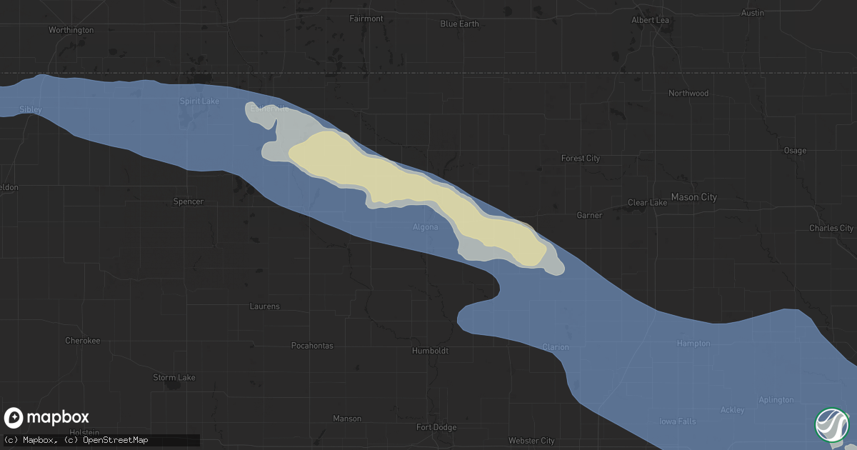
Hail Map in Algona, IA on June 11, 2025
Get this storm
June 11 map
$229
one time, instant access
Download today. No call, no setup
Keep the $229
Bought the map and want the full workflow? Apply the entire $229 to a subscription within 7 days. None of it is wasted.
Every map, not just this one
This buys you this map. Subscription and you get every map we run, in the markets you choose from a few cities to whole states to nationwide. Plus real-time alerts the moment a storm fires.
Contact data
Name, contact info, occupancy, even credit band for addresses in the footprint. You go from where it hit to who to call.
Become the source they trust
Unlimited branding weather history reports on demand. You already have the documented answer ready for the property owner, and you are the one who showed up with it.
Property data and RoofTrace estimates
Pull up any address you have got, its value and the exact code rules for that jurisdiction, straight from One Click Code. Then RoofTrace estimates the squares, pitch, and roof value, priced the way you price.
Storm reports in Algona, IA
Algona, IA
| Date | Description |
|---|---|
| 06/11/20254:29 PM CDT | Social media picture of medium to large tree branch sent through house roof. Time estimated from radar. |
| 06/11/20254:29 PM CDT | Multiple trees damaged with medium to large limbs down. One tree broken off at the base. One outbuilding damaged. Time estimated from radar. |
| 06/11/20254:27 PM CDT | Measured at algona airport. |
All States Impacted by Hail Map on June 11, 2025
All Cities Impacted by Hail Map on June 11, 2025
- Emporia, VA
- Jarratt, VA
- Capron, VA
- Yale, VA
- Courtland, VA
- Drewryville, VA
- Franklin, TX
- Crosby, TX
- Branchville, VA
- Suffolk, VA
- Saint Matthews, SC
- Sumter, SC
- Hobbsville, NC
- Gatesville, NC
- Belvidere, NC
- Silsbee, TX
- Sunbury, NC
- Corapeake, NC
- Gates, NC
- Cameron, SC
- Rock Rapids, IA
- Elloree, SC
- Elizabeth City, NC
- South Mills, NC
- George, IA
- Little Rock, IA
- Sibley, IA
- Ocheyedan, IA
- Santee, SC
- Lake Wales, FL
- Leland, NC
- Harris, IA
- Lake Park, IA
- Pelion, SC
- Summerton, SC
- Effingham, SC
- Leesville, SC
- Spirit Lake, IA
- Akron, IA
- Le Mars, IA
- Marion, SC
- Rich Square, NC
- Clewiston, FL
- New Orleans, LA
- Arabi, LA
- Florence, SC
- Harvey, LA
- Malta, ID
- Aulander, NC
- Kelford, NC
- Roxobel, NC
- Marrero, LA
- American Falls, ID
- Pocatello, ID
- Cheyenne, WY
- Tabor City, NC
- Brunsville, IA
- Batesburg, SC
- Okoboji, IA
- Estherville, IA
- Terril, IA
- Superior, IA
- Firth, ID
- Estero, FL
- Naples, FL
- Nunn, CO
- Wagener, SC
- Aiken, SC
- Carpenter, WY
- Lehigh Acres, FL
- Fort Myers, FL
- Holbrook, ID
- Wallingford, IA
- Ault, CO
- Cherokee, IA
- Aurelia, IA
- Holstein, IA
- Wimauma, FL
- Parrish, FL
- Graettinger, IA
- Ringsted, IA
- Cylinder, IA
- Fenton, IA
- Cloudcroft, NM
- Galva, IA
- Alta, IA
- Pocahontas, IA
- Saint Stephen, SC
- Bonneau, SC
- Jamestown, SC
- Nichols, SC
- Green Sea, SC
- Natchez, LA
- Emmetsburg, IA
- Fair Bluff, NC
- Saint George, SC
- North Fort Myers, FL
- Malad City, ID
- Mayhill, NM
- Punta Gorda, FL
- Moncks Corner, SC
- Pinopolis, SC
- Cerro Gordo, NC
- Clayton, ID
- Challis, ID
- Melvin, IA
- Hartley, IA
- Everly, IA
- Milford, IA
- Spencer, IA
- Fostoria, IA
- Dickens, IA
- Arnolds Park, IA
- Ruthven, IA
- Whittemore, IA
- West Bend, IA
- Lone Rock, IA
- Burt, IA
- Algona, IA
- Bladenboro, NC
- Clarkton, NC
- Rolfe, IA
- Tampa, FL
- Aberdeen, ID
- Pingree, ID
- Cape Coral, FL
- Summerville, SC
- Saint George, GA
- Wayan, ID
- Lacrosse, WA
- Lewiston, ID
- Everson, WA
- Nooksack, WA
- Marlin, WA
- Chelan, WA
- Clarkston, WA
- Waterville, WA
- White Bird, ID
- Dayton, WA
- Deming, WA
- Ritzville, WA
- Mccall, ID
- Imnaha, OR
- Asotin, WA
- Lind, WA
- Washtucna, WA
- Rockport, WA
- Cottonwood, ID
- Stanley, ID
- Yellow Pine, ID
- Orondo, WA
- Pomeroy, WA
- Riggins, ID
- Concrete, WA
- Lucile, ID
- Lynden, WA
- Entiat, WA
- Moses Lake, WA
- Anatone, WA
- Soap Lake, WA
- Lu Verne, IA
- Wesley, IA
- Bode, IA
- Bancroft, IA
- Titonka, IA
- Downey, ID
- Gilmore City, IA
- North Port, FL
- Wesley Chapel, FL
- Bradgate, IA
- Baker, LA
- Baton Rouge, LA
- Corwith, IA
- Britt, IA
- Lava Hot Springs, ID
- Autryville, NC
- Roseboro, NC
- Clinton, NC
- Salemburg, NC
- Ottosen, IA
- Folkston, GA
- Lutz, FL
- Kanawha, IA
- Clarion, IA
- Renwick, IA
- Goldfield, IA
- Hardy, IA
- Livermore, IA
- Garner, IA
- Goodell, IA
- Tererro, NM
- Humboldt, IA
- Garland, NC
- Klemme, IA
- Belmond, IA
- Wausa, NE
- Tarboro, NC
- Cross, SC
- North, SC
- Ladson, SC
- Haynesville, LA
- Ridgeville, SC
- Etna, WY
- Harleyville, SC
- Greenwell Springs, LA
- Sheffield, IA
- Rowan, IA
- Latimer, IA
- Meservey, IA
- Alexander, IA
- Hampton, IA
- Coulter, IA
- Dows, IA
- Macclesfield, NC
- Pinetops, NC
- Elm City, NC
- Wilson, NC
- Hartington, NE
- Dorchester, SC
- Galt, IA
- Alden, IA
- Iowa Falls, IA
- Bradford, IA
- Bondurant, WY
- Webster City, IA
- Eagle Grove, IA
- Vincent, IA
- Woolstock, IA
- Yuma, CO
- Williams, IA
- Blairsburg, IA
- Elsmere, NE
- Popejoy, IA
- Geneva, IA
- Ackley, IA
- Aredale, IA
- Greene, IA
- Bristow, IA
- Dumont, IA
- Chapin, IA
- Duncombe, IA
- Fountain, NC
- Haxtun, CO
- Saint Francisville, LA
- Collinston, LA
- Dougherty, IA
- Weston, WY
- Recluse, WY
- Gillette, WY
- Clarksville, IA
- Parkersburg, IA
- Kesley, IA
- Allison, IA
- Aplington, IA
- Austinville, IA
- Shell Rock, IA
- Steamboat Rock, IA
- Wellsburg, IA
- Eldora, IA
- New Roads, LA
- Wray, CO
- Mer Rouge, LA
- Bastrop, LA
- Mount Vernon, SD
- Chappell, NE
- Jackson, LA
- Ireton, IA
- Martin, SC
- Holland, IA
- New Hartford, IA
- Liberty, MS
- Maurice, IA
- Tripoli, IA
- Readlyn, IA
- Sumner, IA
- Morganza, LA
- Caddo, TX
- Ethan, SD
- Kaycee, WY
- Reinbeck, IA
- Fairbank, IA
- Douglas, WY
- Maynard, IA
- Westgate, IA
- Oelwein, IA
- Riverton, WY
- Dike, IA
- Stanley, NM
- Gladbrook, IA
- Holyoke, CO
- Garrett, WY
- Alexandria, SD
- Haigler, NE
- Saint Francis, KS
- Arriba, CO
- Hudson, IA
- Cedar Falls, IA
- Beaman, IA
- Mitchell, SD
- Traer, IA
- Lincoln, IA
- Stout, IA
- Conrad, IA
- Morrison, IA
- Grundy Center, IA
- Dunkerton, IA
- Janesville, IA
- Gilbertville, IA
- Waterloo, IA
- Waverly, IA
- Dewar, IA
- La Porte City, IA
- Jesup, IA
- Buckingham, IA
- Raymond, IA
- Evansdale, IA
- Oran, IA
- Hazleton, IA
- Stanley, IA
- Aurora, IA
- Independence, IA
- Strawberry Point, IA
- Lamont, IA
- Winthrop, IA
- Arlington, IA
- Spencer, SD
- Fayette, IA
- Hugo, CO
- Venango, NE
- Union Church, MS
- Smithville, MO
- Clutier, IA
- Dysart, IA
- Mount Auburn, IA
- Garrison, IA
- Masonville, IA
- Manchester, IA
- Dundee, IA
- Edgewood, IA
- Arthur, NE
- Moriarty, NM
- Waco, TX
- Aquilla, TX
- Crowheart, WY
- Salem, SD
- Big Springs, NE
- Trimble, MO
- Edgerton, MO
- Meadville, MS
- Rowley, IA
- Walker, IA
- Brandon, IA
- Vinton, IA
- Greeley, IA
- Doss, TX
- Estancia, NM
- Fredericksburg, TX
- Mason, TX
- Port Allen, LA
- Urbana, IA
- Center Point, IA
- Toddville, IA
- Shellsburg, IA
- Palo, IA
- Llano, TX
- Van Horne, IA
- Alburnett, IA
- Coggon, IA
- Ryan, IA
- Central City, IA
- Earlville, IA
- Grant, NE
- Bertram, TX
- Wesson, MS
- Buffalo, WY
- Whitman, NE
- Ogallala, NE
- Keystone, NE
- Paxton, NE
- Ranger, TX
- Slaughter, LA
- Ethel, LA
- Rochelle, TX
- Strawn, TX
- Riverside, OR
- Jordan Valley, OR
- Mullen, NE
- Richland Springs, TX
- Santo, TX
- Mingus, TX
- Stephenville, TX
- Boerne, TX
- Kendalia, TX
- Martin, SD
- Gordon, TX
- Adrian, OR
- Prairie City, OR
- Bergheim, TX
- Eastland, TX
- Spring Branch, TX
- Ironside, OR
- Plainfield, IA
- Seneca, NE
- Palisade, NE
- Hyannis, NE
- San Antonio, TX
- Helotes, TX
- Allen, SD
- Hayes Center, NE
- Thedford, NE
- Mico, TX
- Porcupine, SD
- Wanblee, SD
- Rio Medina, TX
- Port O'Connor, TX
- Canyon Lake, TX
- Port Lavaca, TX
- Palacios, TX
- Yoakum, TX
- Wimberley, TX
- San Marcos, TX
- Interior, SD
- Hallettsville, TX
- New Braunfels, TX
- Fischer, TX
- Weimar, TX
- Homer, LA
- Fayetteville, TX
- Hondo, TX
- Castroville, TX
- Ellinger, TX
- Lolita, TX
- Hempstead, TX
- Baytown, TX
- Calvert, TX
- Cameron, TX
- Houston, TX
- Channelview, TX
- La Coste, TX
- Wharton, TX
- Highlands, TX
- Goliad, TX
- Cleveland, TX
- Pasadena, TX
- Shepherd, TX
- Devine, TX
- Palestine, TX
- Jbsa Ft Sam Houston, TX
- Atascosa, TX
- Coldspring, TX
- Goodrich, TX
- Livingston, TX
- Bay City, TX
- Matagorda, TX
- Von Ormy, TX
- Moscow, TX
- Corrigan, TX
- Groveton, TX
- George West, TX
- Crockett, TX
- Lovelady, TX
- Dayton, TX
- Yorktown, TX


