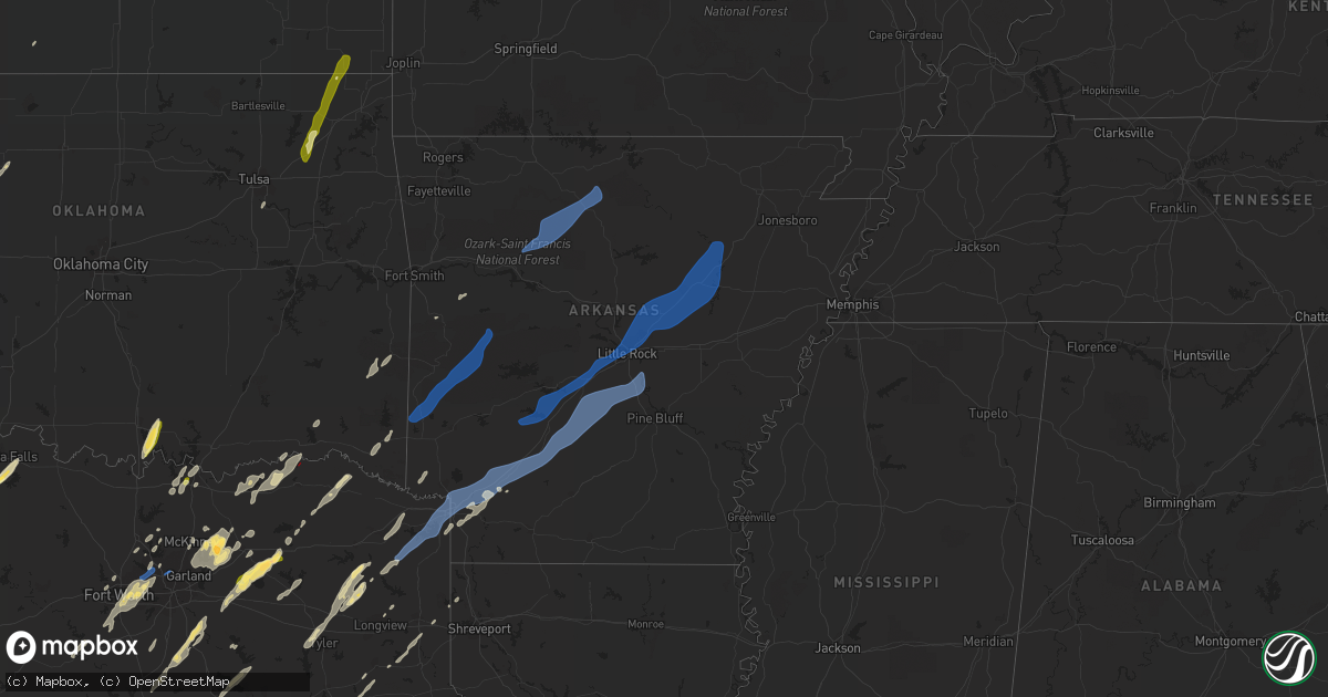
Hail Map in Arkansas on November 4, 2022
Get this storm
November 4 map
$229
one time, instant access
Download today. No call, no setup
Keep the $229
Bought the map and want the full workflow? Apply the entire $229 to a subscription within 7 days. None of it is wasted.
Every map, not just this one
This buys you this map. Subscription and you get every map we run, in the markets you choose from a few cities to whole states to nationwide. Plus real-time alerts the moment a storm fires.
Contact data
Name, contact info, occupancy, even credit band for addresses in the footprint. You go from where it hit to who to call.
Become the source they trust
Unlimited branding weather history reports on demand. You already have the documented answer ready for the property owner, and you are the one who showed up with it.
Property data and RoofTrace estimates
Pull up any address you have got, its value and the exact code rules for that jurisdiction, straight from One Click Code. Then RoofTrace estimates the squares, pitch, and roof value, priced the way you price.
Storm reports in Arkansas
Arkansas
| Date | Description |
|---|---|
| 11/04/20226:57 PM CDT | Tornadic debris signature from ksrx. |
| 11/04/20226:57 PM CDT | Trees and power poles downed. |
| 11/04/20226:57 PM CDT | Tornadic debris signature from ksrx. |
| 11/04/20226:55 PM CDT | Damage to the roof of a chicken house and trees down. |
| 11/04/20226:44 AM CDT | At 1143 PM CDT, a severe thunderstorm was located near Pine Bluff Arsenal, or 9 miles north of Pine Bluff, moving east at 50 mph. HAZARD...60 mph wind gusts. SOURCE...Radar indicated. IMPACT...Expect damage to roofs, siding, and trees. Locations impacted include... Pine Bluff... Stuttgart... Lonoke... Clarendon... Hazen... De Valls Bluff... England... Carlisle... Altheimer... Humphrey... Fredonia... Humnoke... Almyra... Ulm... Roe... Barrettsville... Allendale... Dobbs Landing... McCreanor... Stuttgart Municipal Airport... |
| 11/04/20226:43 AM CDT | At 1143 PM CDT, severe thunderstorms were located along a line extending from 10 miles east of Junction City to Bernice to near Arcadia, moving east at 20 mph. HAZARD...60 mph wind gusts. SOURCE...Radar indicated. IMPACT...Expect damage to roofs, siding, and trees. Locations impacted include... Ruston, Grambling, Farmerville, Bernice, Cooley, Dubach, Choudrant, Simsboro, Marion, Vienna, Downsville, Spearsville, Lillie, D Arbonne, Mount Zion, Oakland, Taylorville, Bayou D Arbonne Lake, Cecil and Shiloh. |
| 11/04/20226:37 AM CDT | At 1137 PM CDT, severe thunderstorms were located along a line extending from 6 miles south of Gravel Hill to Beebe to near Sylvania, moving northeast at 65 mph. HAZARD...60 mph wind gusts. SOURCE...Radar indicated. IMPACT...Expect damage to roofs, siding, and trees. Locations impacted include... Cabot... Searcy... Lonoke... Augusta... Des Arc... Beebe... Ward... Bald Knob... Austin in Lonoke County... Judsonia... Kensett... Higginson... Patterson... Russell... West Point... Tupelo... Old Austin... Crosby... Meto... Thurman... |
| 11/04/20226:30 AM CDT | At 1129 PM CDT, severe thunderstorms were located along a line extending from 8 miles southeast of Carthage to 6 miles north of Calion, moving east at 15 mph. HAZARD...60 mph wind gusts and penny size hail. SOURCE...Radar indicated. IMPACT...Expect damage to roofs, siding, and trees. Locations impacted include... Pine Bluff... Warren... Fordyce... Rison... Hampton... Hermitage... Kingsland... Thornton... Harrell... Ingalls... Ellisville... Hilo... Lamont... Hampton Municipal Airport... Hebron... Moro Bay... Kedron... Weeks... Mt Elba... Moro Bay State Park... |
| 11/04/20226:05 AM CDT | At 1105 PM CDT, severe thunderstorms were located along a line extending from Highland Industrial Park to near Lisbon to 9 miles northeast of Homer, moving east at 45 mph. HAZARD...60 mph wind gusts. SOURCE...Radar indicated. IMPACT...Expect damage to roofs, siding, and trees. Locations impacted include... El Dorado, Smackover, Norphlet, Huttig, Junction City, Strong, Calion, Wesson, Lisbon, Urbana, Lawson, Lapile, Moro Bay State Park, Felsenthal, Newell, New London, Pigeon Hill, Kenova, Catesville and Hew Hope. |
| 11/04/20226:05 AM CDT | At 1104 PM CDT, a severe thunderstorm was located near Pine Bluff Arsenal, or 11 miles east of Sheridan, moving east at 45 mph. HAZARD...60 mph wind gusts. SOURCE...Radar indicated. IMPACT...Expect damage to roofs, siding, and trees. Locations impacted include... Pine Bluff... Stuttgart... White Hall... England... Wrightsville... Redfield... Altheimer... Humphrey... Humnoke... Almyra... Keo... Estes... Orion... Stuttgart Municipal Airport... Hensley Island... Brummitt... Pine Bluff Arsenal... Parkers Corner... Madding... Warbritton... |
| 11/04/20226:02 AM CDT | At 1102 PM CDT, severe thunderstorms were located along a line extending from near Mountain View to near Heber Springs to near Pickles Gap, moving east at 65 mph. HAZARD...60 mph wind gusts. SOURCE...Radar indicated. IMPACT...Expect damage to roofs, siding, and trees. Locations impacted include... Batesville... Newport... Heber Springs... Mountain View... Black Rock... Lake Charles State Park... Bald Knob... Cave City... Tuckerman... Diaz... Newark... Greers Ferry... Quitman... Imboden... Pangburn... Rose Bud... Cushman... Mount Pleasant... Pleasant Plains... Enola... |
| 11/04/20225:57 AM CDT | At 1057 PM CDT, severe thunderstorms were located along a line extending from near Maumelle to West Little Rock to near Benton, moving east at 40 mph. HAZARD...60 mph wind gusts. SOURCE...Radar indicated. IMPACT...Expect damage to roofs, siding, and trees. Locations impacted include... Little Rock... North Little Rock... Conway... Sherwood... Jacksonville... Cabot... West Little Rock... Maumelle... Bryant... Downtown Little Rock... Lonoke... North Little Rock Airport... Little Rock AFB... Southwest Little Rock... Beebe... Ward... Vilonia... Shannon Hills... Mayflower... Wrightsville... |
| 11/04/20225:30 AM CDT | At 1030 PM CDT, severe thunderstorms were located along a line extending from near Shongaloo to near Haughton, moving east at 25 mph. HAZARD...60 mph wind gusts. SOURCE...Radar indicated. IMPACT...Expect damage to roofs, siding, and trees. Locations impacted include... Bossier City, Minden, Homer, Haughton, Haynesville, Sibley, Cotton Valley, Gibsland, Sarepta, Doyline, Dubberly, Dixie Inn, Shongaloo, Eastwood, Evergreen, Athens, Lisbon, Mount Lebanon, Leton and Fillmore. |
| 11/04/20225:23 AM CDT | At 1023 PM CDT, a severe thunderstorm was located 12 miles west of Leola, or 15 miles east of Arkadelphia, moving northeast at 65 mph. HAZARD...60 mph wind gusts and nickel size hail. SOURCE...Radar indicated. IMPACT...Expect damage to roofs, siding, and trees. Locations impacted include... Little Rock... Benton... Bryant... Malvern... Sheridan... Haskell... Shannon Hills... Rockport... Caddo Valley... Traskwood... Leola... Tull... Sparkman... Carthage... Prattsville... Poyen... Perla... Cane Creek... Jenkins Ferry State Park... East End... |
| 11/04/20225:20 AM CDT | At 1020 PM CDT, severe thunderstorms were located along a line extending from near Watts to Hill Creek, moving northeast at 55 mph. HAZARD...60 mph wind gusts and penny size hail. SOURCE...Radar indicated. IMPACT...Expect damage to roofs, siding, and trees. Locations impacted include... Heber Springs... Mountain View... Clinton... Fairfield Bay... Marshall... Greenbrier... Calico Rock... Greers Ferry... Wooster... Quitman... Guy... Rose Bud... Damascus... Twin Groves... Menifee... Shirley... Pineville... Higden... Bethlehem... Hill Creek... |
| 11/04/20225:18 AM CDT | At 1017 PM CDT, severe thunderstorms were located along a line extending from 8 miles southwest of Williams Junction to Lonsdale to 8 miles east of Hot Springs, moving northeast at 45 mph. HAZARD...60 mph wind gusts and quarter size hail. SOURCE...Radar indicated. IMPACT...Hail damage to vehicles is expected. Expect wind damage to roofs, siding, and trees. Locations impacted include... Little Rock... North Little Rock... Conway... Benton... West Little Rock... Maumelle... Bryant... Hot Springs Village... Perryville... Southwest Little Rock... Greenbrier... Haskell... Shannon Hills... Mayflower... Wooster... Oppelo... Traskwood... Menifee... Perry... Adona... |
| 11/04/20224:40 AM CDT | At 940 PM CDT, a severe thunderstorm was located over Emmet, or 8 miles south of Prescott, moving northeast at 60 mph. HAZARD...60 mph wind gusts and nickel size hail. SOURCE...Radar indicated. IMPACT...Expect damage to roofs, siding, and trees. Locations impacted include... Arkadelphia... Gurdon... Caddo Valley... Sparkman... Chidester... Okolona... Whelen Springs... Beirne... Gum Springs in Clark County... Richwoods... White Oak Lake State Park... Donaldson... Friendship... Tulip... Curtis... Ouachita... Reader... Vaden... Dalark... Midway in Hot Spring County... |
| 11/04/20224:38 AM CDT | At 937 PM CDT, severe thunderstorms were located along a line extending from near Okolona to near Prescott to Bodcaw, moving northeast at 45 mph. HAZARD...60 mph wind gusts and quarter size hail. SOURCE...Radar indicated. IMPACT...Hail damage to vehicles is expected. Expect wind damage to roofs, siding, and trees. Locations impacted include... Prescott, Emmet, Rosston, Willisville, Bodcaw, Bluff City, White Oak Lake State Park, Cale, Young, Sutton, Waterloo, Falcon, Boughton, Mount Moriah, Morris, Laneburg and Reader. |
| 11/04/20224:33 AM CDT | At 932 PM CDT, severe thunderstorms were located along a line extending from Lake Dardanelle to north of Hollis, moving northeast at 55 mph. HAZARD...60 mph wind gusts and penny size hail. SOURCE...Radar indicated. IMPACT...Expect damage to roofs, siding, and trees. Locations impacted include... Russellville... Morrilton... Clinton... Perryville... Dardanelle... Atkins... Pottsville... Dover... London... Oppelo... Hector... Perry... Adona... Sequoya Park... Lake Dardanelle State Park... Happy Bend... Dabney... Hattieville... Jerusalem... Blick... |
| 11/04/20224:11 AM CDT | At 911 PM CDT, a severe thunderstorm was located 8 miles west of Lake Ouachita State Park, or 17 miles northwest of Hot Springs, moving northeast at 35 mph. HAZARD...60 mph wind gusts and quarter size hail. SOURCE...Radar indicated. IMPACT...Hail damage to vehicles is expected. Expect wind damage to roofs, siding, and trees. Locations impacted include... Jessieville... Lake Ouachita State Park... Avant... Lena Landing Rec Area... Hamilton... Crystal Springs Landing... Mt Tabor... Hollis... Crystal Springs... |
| 11/04/20223:29 AM CDT | At 828 PM CDT, a severe thunderstorm was located over Upper Buffalo Wilderness Area, or 13 miles southwest of Jasper, moving northeast at 40 mph. HAZARD...60 mph wind gusts and quarter size hail. SOURCE...Radar indicated. IMPACT...Hail damage to vehicles is expected. Expect wind damage to roofs, siding, and trees. Locations impacted include... Jasper... Western Grove... Valley Springs... Dugger... Carver... Erbie... Upper Buffalo Wilderness Area... Lost Valley State Park... Piercetown... Pruitt... Crawford... Everton... St. Joe... Pindall... Marble Falls... Yardelle... Swain... Gum Springs in Newton County... Eros... Bruno... |
| 11/04/20223:27 AM CDT | At 826 PM CDT, severe thunderstorms were located along a line extending from near Rosetta to 9 miles northwest of Broomfield to near Holman, moving northeast at 50 mph. HAZARD...60 mph wind gusts. SOURCE...Radar indicated. IMPACT...Expect damage to roofs, siding, and trees. Locations impacted include... Marshall... Lamar... Dover... Knoxville... Hector... Marsena... Witts Spring... Rocky Hill... Moore... Duff... Dabney... Point Peter... Bohannon... Imo... Elberta... Watts... Holman... Rosetta... Kay... Dillen... |
| 11/04/20221:55 AM CDT | At 654 PM CDT, severe thunderstorms were located along a line extending from 4 miles north of Brentwood to 5 miles southeast of Winslow to near Dyer, moving northeast at 65 mph. HAZARD...60 mph wind gusts. SOURCE...Radar indicated. IMPACT...Expect damage to roofs, siding, and trees. Locations in or near the path include... Ozark... Huntsville... Mountainburg... Elkins... West Fork... Mulberry... Dyer... Winslow... Chester... St. Paul... Wesley... Rudd... Saint Paul... Aurora... Boston... Withrow Springs State Park... Brentwood... Lake Fort Smith... Marble... Cass...This includes the following highways, Interstate 40 in Arkansas between mile markers 15 and 34. Interstate 49 between mile markers 29 and 44, and between milemarkers 46 and 48. |
| 11/03/202211:50 PM CDT | At 450 PM CDT, a severe thunderstorm was located 5 miles east of Keota, moving northeast at 40 mph. HAZARD...60 mph wind gusts. SOURCE...Radar indicated. IMPACT...Expect damage to roofs, siding, and trees. Locations in or near the path include... Muldrow... Roland... Keota... Bokoshe... Gans... Cowlington... Cottonwood... Dora...This includes Interstate 40 in Oklahoma between mile markers 310 and328. |
| 11/03/202211:44 PM CDT | Tree reported blown down in furlow. |
| 11/03/202211:35 PM CDT | Several large tree limbs were snapped off in the area. |
| 11/03/202211:30 PM CDT | Trees down in cabot. |
| 11/03/202211:27 PM CDT | Part of a metal roof covering a porch was peeled back. |
| 11/03/202211:10 PM CDT | Several large tree limbs were snapped off... Resulting in isolated power outages. |
| 11/03/202211:06 PM CDT | Multiple trees and powelines down on east sardis road. Structues damaged... Possible tornado. |
| 11/03/202211:04 PM CDT | Nws survey revealed an ef2 tornado southeast of sardis. This tornado started on cardinal circle... Uprooting or snapping trees as it moved northeast over west fairview |
| 11/03/202210:01 PM CDT | Nws survey revealed an ef1 tornado southeast of curtis. This tornado started just southwest of vaden road... Continuing northeast across 2nd road towards newton and cop |
| 11/03/20229:58 PM CDT | Trees and powerlines down. |
| 11/03/20229:49 PM CDT | The tornado began along little texas road south of hwy 28 in yell county. Several pine and hardwood trees were either snapped or uprooted along little texas road and bi |
| 11/03/20229:34 PM CDT | Numerous trees were blown down throughout the county. Downed trees temporarily blocked hwy 62 east... Hwy 5 south... And hwy 178 west... As well as numerous county road |
| 11/03/20229:15 PM CDT | Several chicken houses and barns sustained damage. A number of trees were also blown down. Time was estimated by radar. |
| 11/03/20228:56 PM CDT | Tractor trailer overturned on i-30 bridge over the red river in fulton... Arkansas blocking both east and westbound lanes. |
| 11/03/20228:44 PM CDT | The roof of a vacant house located on lake norfork drive collapsed. A collapsed roof at an outdoor boat storage business located on hwy 62 east resulted damage to sever |
| 11/03/20228:43 PM CDT | This brief tornado developed along a strong rear flank downdraft surge that swept across areas immediately southeast of wickes... Ar. Several chicken houses immediately |
| 11/03/20228:32 PM CDT | At least two homes received damage... One with extensive roof damage... Located on hwy. 26 near the possum hollow road intersection. The other home damage was near hwy. |
| 11/03/20228:22 PM CDT | Trees and powelones down in pine ridge. |
| 11/03/20228:19 PM CDT | Trees and powerlines down in amity. |
| 11/03/20228:17 PM CDT | Trees and powerlines down in cherry hill. |
| 11/03/20228:07 PM CDT | A few trees were blown down. This is a delayed report. |
| 11/03/20228:06 PM CDT | Trees and powerlines down in kirby. |
| 11/03/20228:03 PM CDT | Trees and powerlines down across arkansas 14. |
| 11/03/20227:46 PM CDT | Tornadic debris signature from ksrx. |
| 11/03/20227:45 PM CDT | Trees and power poles downed. Damage to the roof of a grocery store. |
| 11/03/20227:44 PM CDT | Report of a tree downed across hwy 23... South of hwy 288 intersection. Also took down a power line. *possible tornado*. |
| 11/03/20227:41 PM CDT | Trees and powerlines down in wickes. |
| 11/03/20227:41 PM CDT | Local coordinator reported four chicken houses and twelve homes damaged in the wickes area. |
| 11/03/20227:24 PM CDT | Tornadic debris signature from ksrx. |
All States Impacted by Hail Map on November 4, 2022
Cities Impacted by Hail Map on November 4, 2022
- Sun Prairie, WI
- Columbus, WI
- Waterloo, WI
- Marshall, WI
- Verona, WI
- Mount Horeb, WI
- Madison, WI
- Booneville, AR
- Magazine, AR
- Lowden, IA
- Wheatland, IA
- Lost Nation, IA
- Baldwin, IA
- Maquoketa, IA
- Oxford Junction, IA
- Circleville, KS
- Holton, KS
- Soldier, KS
- Havensville, KS
- Coggon, IA
- Central City, IA
- Fairview, OK
- Isabella, OK
- Longdale, OK
- Darlington, WI
- Scales Mound, IL
- Elizabeth, IL
- Gratiot, WI
- Hanover, IL
- South Wayne, WI
- Bellevue, IA
- Argyle, WI
- Shullsburg, WI
- Apple River, IL
- Galena, IL
- Longview, TX
- Seagoville, TX
- Bynum, TX
- Waxahachie, TX
- Frost, TX
- Milford, TX
- Blooming Grove, TX
- Palmer, TX
- Hillsboro, TX
- Italy, TX
- Mertens, TX
- Ferris, TX
- Ennis, TX
- Broken Bow, OK
- Idabel, OK
- Foreman, AR
- Alleene, AR
- Ashdown, AR
- Cumby, TX
- Sulphur Springs, TX
- Brashear, TX
- Wills Point, TX
- Kaufman, TX
- Lone Oak, TX
- Point, TX
- Quinlan, TX
- Terrell, TX
- Chariton, IA
- Pecatonica, IL
- Ridott, IL
- Davis, IL
- Durand, IL
- Rock City, IL
- Avoca, TX
- Lueders, TX
- Throckmorton, TX
- Stamford, TX
- Albany, TX
- Hawley, TX
- Anson, TX
- Caddo Mills, TX
- Nevada, TX
- Farmersville, TX
- Royse City, TX
- Lewisville, TX
- Gilmer, TX
- Aquilla, TX
- Kingsbury, TX
- Piedmont, KS
- Sumner, TX
- Boswell, OK
- Hugo, OK
- Arthur City, TX
- Honobia, OK
- Hodgen, OK
- Muse, OK
- Whitesboro, OK
- Dike, TX
- Rattan, OK
- Spencerville, OK
- Denison, TX
- Cottage Grove, WI
- Cambridge, WI
- Stoughton, WI
- Deerfield, WI
- Detroit, TX
- Celeste, TX
- Little Elm, TX
- Marlin, TX
- Thornton, TX
- Kosse, TX
- Reagan, TX
- Fort Worth, TX
- Humeston, IA
- Garden Grove, IA
- Derby, IA
- Russell, IA
- Holliday, TX
- Henrietta, TX
- Wichita Falls, TX
- Pittsburg, TX
- Big Sandy, TX
- New Boston, TX
- Simms, TX
- De Kalb, TX
- Naples, TX
- Omaha, TX
- Sherman, TX
- Pottsboro, TX
- Temple, TX
- Moody, TX
- Crawford, TX
- Valley Mills, TX
- Junction City, KS
- Manhattan, KS
- Howe, TX
- Whitesboro, TX
- Texarkana, AR
- Queen City, TX
- Karnack, TX
- Mooringsport, LA
- Diana, TX
- Harleton, TX
- Fort Hood, TX
- Killeen, TX
- Greenville, TX
- Carrollton, TX
- Waskom, TX
- Cushing, TX
- Rusk, TX
- Tatum, TX
- Beckville, TX
- Marshall, TX
- Kerens, TX
- Corsicana, TX
- Oil City, LA
- Lena, IL
- Carter, OK
- Vinson, OK
- Willow, OK
- Mangum, OK
- Mcfarland, WI
- Bixby, OK
- Chelsea, OK
- Adair, OK
- Maxwell, TX
- San Marcos, TX
- Lamoni, IA
- Davis City, IA
- Belton, TX
- Arlington, TX
- Euless, TX
- Argyle, TX
- Lanark, IL
- Shannon, IL
- Haltom City, TX
- Burleson, TX
- Irving, TX
- Kennedale, TX
- Godley, TX
- Hurst, TX
- North Richland Hills, TX
- Grand Prairie, TX
- Crowley, TX
- Bedford, TX
- Joshua, TX
- Dallas, TX
- Colleyville, TX
- Wolfe City, TX
- New Berlin, WI
- Dale, TX
- Cedar Creek, TX
- Elk City, OK
- Foss, OK
- Butler, OK
- Clinton, OK
- Dill City, OK
- Canute, OK
- Mabank, TX
- Kemp, TX
- Scotland, TX
- Olney, TX
- Bagwell, TX
- Clarksville, TX
- Wortham, TX
- Luling, TX
- Attica, KS
- Savanna, IL
- Clinton, IA
- De Witt, IA
- Mount Carroll, IL
- Thomson, IL
- Sabula, IA
- Welch, OK
- Leon, IA
- Emmet, AR
- Madill, OK
- Marietta, OK
- Ardmore, OK
- Mannsville, OK
- Commerce, TX
- Abilene, TX
- Henderson, TX
- Aubrey, TX
- Hughes Springs, TX
- Daingerfield, TX
- Lone Star, TX
- Avinger, TX
- Tyler, TX
- Muskego, WI
- Big Bend, WI
- Waukesha, WI
- Harrold, TX
- Davidson, OK
- Marion, IA
- Homestead, IA
- Fairfax, IA
- Oxford, IA
- Ely, IA
- Amana, IA
- Cedar Rapids, IA
- Swisher, IA
- Allen, TX
- Mckinney, TX
- Deport, TX
- Mansfield, AR
- Trinidad, TX
- Malakoff, TX
- Streetman, TX
- Lindale, TX
- Chandler, TX
- Winnsboro, TX
- Hawkins, TX
- Garland City, AR
- Hope, AR
- Fouke, AR
- Lewisville, AR
- Oglesby, TX
- Gatesville, TX
- Bogata, TX
- Lockhart, TX
- Honey Grove, TX
- Brookston, TX
- Laneville, TX
- Dodd City, TX
- Bonham, TX
- Windom, TX
- Telephone, TX
- Denton, TX
- Pryor, OK
- Claremore, OK
- Big Cabin, OK
- Anna, TX
- Blue Ridge, TX
- Haskell, TX
- Wylie, TX
- Sachse, TX
- Lavon, TX
- Princeton, TX
- Plano, TX
- Leonard, TX
- Rockwall, TX
- Pearl City, IL
- Low Moor, IA
- Fulton, IL
- Goose Lake, IA
- Camanche, IA
- Bryant, IA
- McGregor, TX
- Powderly, TX
- Grant, OK
- Petty, TX
- Paris, TX
- Mukwonago, WI
- Reeseville, WI
- Rule, TX
- Oregon, WI
- Brooklyn, WI
- Alba, TX
- Yantis, TX
- Fruitvale, TX
- Quitman, TX
- Grand Saline, TX
- Emmett, KS
- Onaga, KS
- Wyoming, IA
- Center Junction, IA
- Bluejacket, OK
- Chadwick, IL
- Coppell, TX
- Grapevine, TX
- Seguin, TX
- Mounds, OK
- Cleburne, TX
- Granbury, TX
- Glen Rose, TX
- Rainbow, TX
- Maypearl, TX
- Midlothian, TX
- Grapeland, TX
- Addison, TX
- Bartlett, KS
- Chetopa, KS
- Vinita, OK
- Oswego, KS
- Columbus, KS
- Archer City, TX
- Horicon, WI
- Juneau, WI
- Beaver Dam, WI
- Lake Mills, WI
- Hales Corners, WI
- Milwaukee, WI
- Gillham, AR
- Bluffton, AR
- Oden, AR
- Vandervoort, AR
- Mount Ida, AR
- Gravelly, AR
- Harvey, AR
- Pencil Bluff, AR
- Umpire, AR
- Mena, AR
- Wickes, AR
- Grannis, AR
- Dover, AR
- Saint Joe, AR
- Hagarville, AR
- Marshall, AR
- Yellville, AR
- Witts Springs, AR
- Mount Judea, AR
- Pelsor, AR
- Harriet, AR
- Gilbert, AR
- Newport, AR
- Augusta, AR
- Traskwood, AR
- Malvern, AR
- Oil Trough, AR
- Ward, AR
- Jacksonville, AR
- Beebe, AR
- Vilonia, AR
- Bryant, AR
- Lonoke, AR
- Judsonia, AR
- Kensett, AR
- Bismarck, AR
- Alexander, AR
- Romance, AR
- Little Rock, AR
- Cabot, AR
- Lonsdale, AR
- Donaldson, AR
- Des Arc, AR
- Bradford, AR
- Little Rock Air Force Base, AR
- Benton, AR
- McRae, AR
- Bald Knob, AR
- Garner, AR
- Russell, AR
- Griffithville, AR
- Sherwood, AR
- Searcy, AR
- North Little Rock, AR
- Pleasant Plains, AR
- Amity, AR
- El Paso, AR
- Thida, AR
- Arkadelphia, AR
- Higginson, AR
- Hot Springs National Park, AR
- Austin, AR
- Redfield, AR
- Linden, TX
- Gurdon, AR
- Hooks, TX
- Douglassville, TX
- Carthage, AR
- Sheridan, AR
- Jefferson, AR
- England, AR
- Sparkman, AR
- Fulton, AR
- Prattsville, AR
- Atlanta, TX
- Bauxite, AR
- Texarkana, TX
- Marietta, TX
- Prescott, AR
- Ogden, AR
- Poyen, AR
- Maud, TX
- Nash, TX
- Hensley, AR
- Washington, AR
- Leola, AR
- Poteau, OK
- Hartford, AR
- Heavener, OK
- Winona, TX
- Huntington, AR
- Greenwood, AR
- Elkins, AR
- Fayetteville, AR
- Ore City, TX
- Eagletown, OK
- Smithville, OK
- Hartman, AR
- Coal Hill, AR
- Clarksville, AR
- Ozark, AR
- Altus, AR
- Mabelvale, AR
- Athens, TX


