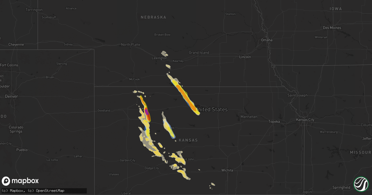
Hail Map on September 19, 2025
Get this storm
September 19 map
$229
one time, instant access
Download today. No call, no setup
Keep the $229
Bought the map and want the full workflow? Apply the entire $229 to a subscription within 7 days. None of it is wasted.
Every map, not just this one
This buys you this map. Subscription and you get every map we run, in the markets you choose from a few cities to whole states to nationwide. Plus real-time alerts the moment a storm fires.
Contact data
Name, contact info, occupancy, even credit band for addresses in the footprint. You go from where it hit to who to call.
Become the source they trust
Unlimited branding weather history reports on demand. You already have the documented answer ready for the property owner, and you are the one who showed up with it.
Property data and RoofTrace estimates
Pull up any address you have got, its value and the exact code rules for that jurisdiction, straight from One Click Code. Then RoofTrace estimates the squares, pitch, and roof value, priced the way you price.
States Impacted by Hail Map on September 19, 2025
Storm reports
Nebraska
| Date | Description |
|---|---|
| 09/19/20253:07 PM CDT | Estimated winds to around 60 mph at corps of engineers office. |
| 09/19/20253:05 PM CDT | 911 center reports a powerline down north of republican city. |
| 09/19/20253:05 PM CDT | Personal weather station reports gust to 58mph. Time estimated from radar. |
Alabama
| Date | Description |
|---|---|
| 09/19/20253:03 PM CDT | Reports of trees down near russellville. |
| 09/19/20252:55 PM CDT | Trees down along 43n and the frosty inn. |
| 09/19/20251:36 PM CDT | Tree down across rd near county rd 10 & hwy 157. Time estimated by radar. |
| 09/19/20251:30 PM CDT | A power pole was snapped... A couple trees were downed... And a small shed was blown down at the intersection of smith chapel rd and lost creek rd. Time approximate. |
Tennessee
| Date | Description |
|---|---|
| 09/19/20252:42 PM CDT | Tree down blocking the road at eagle nation drive & church street near summertown elementary school. |
Arkansas
| Date | Description |
|---|---|
| 09/19/20258:32 AM CDT | A local report indicates 1.00 inch wind near 2 SSE Caldwell |
Oklahoma
| Date | Description |
|---|---|
| 09/19/20255:54 AM CDT | A local report indicates 62 MPH wind near 7 E Centrailia |
Wisconsin
| Date | Description |
|---|---|
| 09/19/20255:06 PM CDT | Pictur |
| 09/19/20255:06 PM CDT | Picture sent via email from county highway hh. |
| 09/19/20253:12 PM CDT | A local report indicates 1.00 inch wind near Briggsville |
| 09/19/20251:01 AM CDT | A local report indicates 60 MPH wind near Oshkosh |
Kansas
| Date | Description |
|---|---|
| 09/19/20256:35 PM CDT | Pws - 789_homestead. |
| 09/19/20255:12 PM CDT | Report from mping: ping pong ball |
| 09/19/20255:10 PM CDT | Hail up to half dollar size...most smaller. |
| 09/19/20255:09 PM CDT | Report from mping: hen egg |
| 09/19/20255:05 PM CDT | Report from mping: hen egg+ |
| 09/19/20255:05 PM CDT | Report from mping: hen egg+ |
| 09/19/20255:05 PM CDT | Accumulating hail up to 2 inches in diameter. |
| 09/19/20255:04 PM CDT | Report from mping: hen egg |
| 09/19/20255:04 PM CDT | Report from mping: golf ball |
| 09/19/20254:44 PM CDT | Kkshoxie18 wx underground. |
| 09/19/20254:04 PM CDT | Photos and video on social media of dime to quarter sized hail near athol. Hail covering the ground. |
| 09/19/20253:19 PM CDT | Golfball size hail in jennings. |
| 09/19/20253:17 PM CDT | Most of the hail was nickel to half dollar size... Only a few were golf ball. Lasted around 10 minutes. Corrects previous hail report from jennings. Golfball size hail |
| 09/18/20258:15 PM CDT | A local report indicates 1.00 inch wind near Utica |
| 09/18/20257:41 PM CDT | A local report indicates 1.00 inch wind near 1 N Liebenthal |
| 09/18/20257:15 PM CDT | Kansas mesonet site - hays. |
| 09/18/20257:00 PM CDT | Kksquint19 wx underground. |
| 09/18/20257:00 PM CDT | Kksquint19 wx underground. ( |
Mississippi
| Date | Description |
|---|---|
| 09/19/20251:22 PM CDT | Location of a tree down on deer park rd received from a resident on facebook. 911 call center also reported multiple trees down across the tupelo area. |
Arizona
| Date | Description |
|---|---|
| 09/19/20253:00 PM CDT | Report from social media. |
Cities Impacted by Hail Map on September 19, 2025
- Holly Grove, AR
- Palestine, AR
- Colt, AR
- Forrest City, AR
- Elaine, AR
- Stapleton, NE
- Jefferson, TX
- Overton, NE
- Sumner, NE
- Pontotoc, MS
- Randolph, MS
- Houlka, MS
- Stephens, AR
- Leola, AR
- Waterloo, AL
- Lutts, TN
- Carthage, AR
- Camden, AR
- Cypress Inn, TN
- Tupelo, MS
- Iron City, TN
- Belden, MS
- Saltillo, MS
- Eddyville, NE
- Shannon, MS
- Okolona, MS
- Centerville, TN
- Hohenwald, TN
- Westpoint, TN
- Jefferson, AR
- Redfield, AR
- Loomis, NE
- Elm Creek, NE
- Holdrege, NE
- Star City, AR
- White Hall, AR
- Hackleburg, AL
- Phil Campbell, AL
- New Edinburg, AR
- Spruce Pine, AL
- Russellville, AL
- Summertown, TN
- Seligman, AZ
- Orleans, NE
- Alma, NE
- Atlanta, NE
- Ethridge, TN
- Republican City, NE
- Naponee, NE
- Lonoke, AR
- Vanleer, TN
- Pulaski, TN
- Portage, WI
- Briggsville, WI
- Wisconsin Dells, WI
- Kensington, KS
- Bloomington, NE
- Smith Center, KS
- Agra, KS
- Jennings, KS
- Norcatur, KS
- Cumberland Furnace, TN
- Oberlin, KS
- Oxford, WI
- Franklin, NE
- Dresden, KS
- Williams, AZ
- Ash Fork, AZ
- Herndon, KY
- Waynesboro, TN
- Adams, WI
- Grand Marsh, WI
- Dickson, TN
- Riverton, NE
- Friendship, WI
- Athol, KS
- Arkdale, WI
- Hopkinsville, KY
- Selden, KS
- Gaylord, KS
- McNeal, AZ
- Portis, KS
- Concord, AR
- Clarksville, TN
- Woodlawn, TN
- Pleasant Plains, AR
- Batesville, AR
- Floral, AR
- Poynette, WI
- Burns, TN
- White Bluff, TN
- Elfrida, AZ
- Hoxie, KS
- Lyndon Station, WI
- Animas, NM
- Van Buren, MO
- Downs, KS
- Osborne, KS
- Arrey, NM
- Caballo, NM
- Derry, NM
- Drasco, AR
- Mauston, WI
- Fairview, TN
- Bon Aqua, TN
- Tipton, KS
- Glen Elder, KS
- Savannah, TN
- Ida, AR
- Tumbling Shoals, AR
- Nortonville, KY
- Douglas, AZ
- Crofton, KY
- Madisonville, KY
- Saint Charles, KY
- Dawson Springs, KY
- Hunter, KS
- Lyles, TN
- Heber Springs, AR
- Lobelville, TN
- Beloit, KS
- Sylvan Grove, KS
- Morland, KS
- Florence, AL
- Palco, KS
- Bogue, KS
- Meridian, MS
- Enterprise, MS
- Collyer, KS
- Saint David, AZ
- Willcox, AZ
- Earlington, KY
- Endeavor, WI
- Wilburn, AR
- Ellis, KS
- Plainville, KS
- Providence, KY
- Nebo, KY
- Quinter, KS
- Quitman, AR
- Park, KS
- Caledonia, MN
- Grainfield, KS
- Marble Hill, MO
- Zalma, MO
- Tucson, AZ
- Slaughters, KY
- Manitou, KY
- Dixon, KY
- Hays, KS
- Leopold, MO
- Cawker City, KS
- La Crosse, KS
- Schoenchen, KS
- Liebenthal, KS
- Bison, KS
- McCracken, KS
- Utica, KS
- Gove, KS
- Beeler, KS
- Ransom, KS
- Ness City, KS
- Dighton, KS
- Larned, KS
- Pawnee Rock, KS
- Belpre, KS
- Garfield, KS
- Bazine, KS
- Macksville, KS
- St John, KS
- Hanston, KS
- Burdett, KS
- Lewis, KS
- Jetmore, KS
- Haviland, KS
- Cunningham, KS
- Pratt, KS
- Kinsley, KS
- Offerle, KS
- Coats, KS
- Sawyer, KS
- Medicine Lodge, KS
- Greensburg, KS
- Danville, KS
- Harper, KS
- Anthony, KS
- Argonia, KS
- Ralston, OK
- Ponca City, OK
- Marland, OK
- Pawnee, OK
- Fairfax, OK
- Hominy, OK