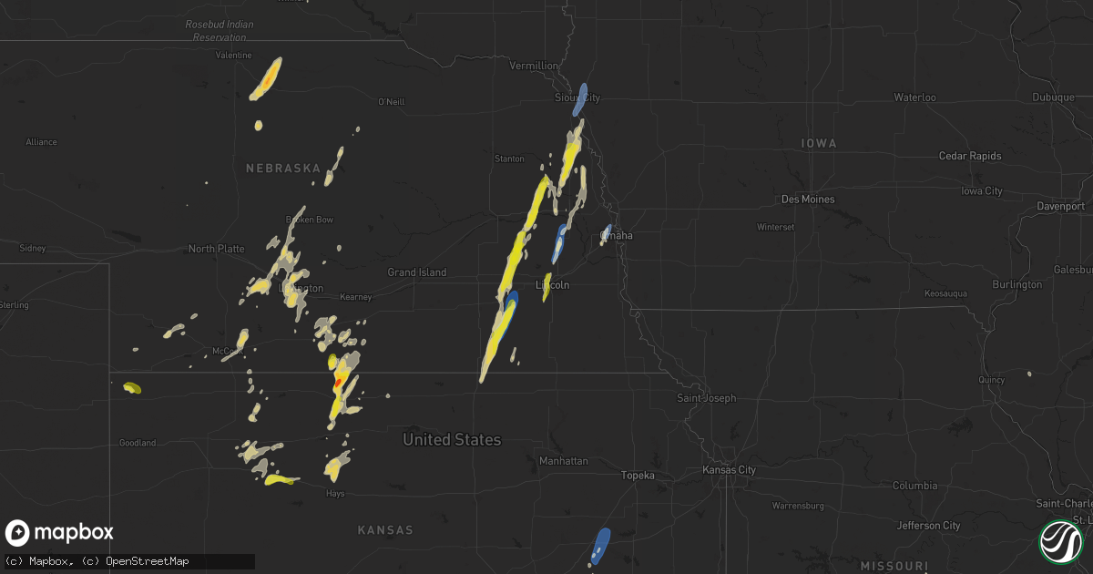
Hail Map on September 14, 2025
Get this storm
September 14 map
$229
one time, instant access
Download today. No call, no setup
Keep the $229
Bought the map and want the full workflow? Apply the entire $229 to a subscription within 7 days. None of it is wasted.
Every map, not just this one
This buys you this map. Subscription and you get every map we run, in the markets you choose from a few cities to whole states to nationwide. Plus real-time alerts the moment a storm fires.
Contact data
Name, contact info, occupancy, even credit band for addresses in the footprint. You go from where it hit to who to call.
Become the source they trust
Unlimited branding weather history reports on demand. You already have the documented answer ready for the property owner, and you are the one who showed up with it.
Property data and RoofTrace estimates
Pull up any address you have got, its value and the exact code rules for that jurisdiction, straight from One Click Code. Then RoofTrace estimates the squares, pitch, and roof value, priced the way you price.
States Impacted by Hail Map on September 14, 2025
Storm reports
Illinois
| Date | Description |
|---|---|
| 09/14/20256:14 PM CDT | Tree knocked down along highway 127 near etherton. |
| 09/14/20256:08 PM CDT | A tree was blown down across pump house rd just north of chautauqua rd. |
| 09/14/20256:05 PM CDT | Quarter size hail reported on the west side of carbondale. |
| 09/14/20256:04 PM CDT | A large tree fell through a mobile home on new era road just north of highway 13. |
| 09/14/20256:03 PM CDT | Trees down along country club road near the murphysboro walmart. Also knocked the power out to the surrounding area. Time estimated from radar. |
| 09/14/20254:47 PM CDT | A tree was blown down along i-57 south of benton. |
| 09/14/20254:41 PM CDT | Hail up to the size of quarters was reported in benton. |
| 09/14/20254:35 PM CDT | A couple of trees were blown down in the south marcum campground on rend lake. |
| 09/13/20257:40 PM CDT | A couple |
| 09/13/20257:40 PM CDT | A couple of trees blown down. Wind speed estimated at 50-60 mph. |
Minnesota
| Date | Description |
|---|---|
| 09/14/20254:22 PM CDT | Thunderstorm wind gust blew down a big tree and took out the power across much of town. There was not much rain... But a couple minutes of very strong wind. |
| 09/14/20254:01 PM CDT | Roof of cattle barn blown off. Tree branches 6 to 10 inches in diameter broken down. |
| 09/14/20253:52 PM CDT | Strong wind gusts knowcked down a big rotten tree in town and also some small branches on other trees. Heavy rain accompanied the wind. |
| 09/14/20253:50 PM CDT | Mesonet station mn006 i-90 - beaver creek mp 4. |
North Dakota
| Date | Description |
|---|---|
| 09/14/20256:48 PM CDT | Storm chaser reports rain wrapped tornado continues. Location estimated based on radar. |
| 09/14/20256:40 PM CDT | Tree on house... Time estimated from radar. |
| 09/14/20256:40 PM CDT | Tree on house... Time estimated from |
| 09/14/20256:18 PM CDT | Corrects previous tornado report from 1 nne butte. Storm chaser report tornado near butte. Tornado started around 606 pm cdt southwest of butte. |
| 09/14/20256:18 PM CDT | Corrects previous tornado report from 1 |
| 09/14/20255:41 PM CDT | Storm chaser reports large wedge tornado in progress. |
| 09/14/20255:32 PM CDT | Storm chaser reports new large multi vortex tornado. |
| 09/14/20255:31 PM CDT | Storm chaser report of a tornado. Radar also showing debris signature about 9 to 10 minutes prior. |
| 09/14/20255:30 PM CDT | Relayed through broadcast media of a tornado 5 to 7 miles south of kief. |
| 09/14/20254:50 PM CDT | Social media post with video of wind gusts... Estimated by observer of 60 mph near i-29 and hwy 13. |
| 09/14/20254:50 PM CDT | A local report indicates 1.00 inch wind near 2 N Balfour |
| 09/14/20254:40 PM CDT | Storm chasers report large wedge tornado and a brief small rope tornado. Large tornado remains ongoing. |
| 09/14/20254:31 PM CDT | Storm chaser report multi vortex tornado continues. |
| 09/14/20254:12 PM CDT | Storm chaser reports multiple vortex tornado. |
| 09/14/20254:09 PM CDT | Storm chaser reports tornado. |
| 09/14/20254:01 PM CDT | Storm chaser reports tornado near arena. |
| 09/14/20253:57 PM CDT | Storm chaser reports large tornado on ground. Began about five minutes ago. Also reports tree damage. |
| 09/14/20253:42 PM CDT | Storm chaser reports tornado north of driscoll. |
| 09/14/20253:30 PM CDT | Storm chaser reports tornado just east of menoken. |
| 09/14/20252:54 PM CDT | Multiple reports of multiple cone tornadoes north of hazelton recreation area. |
| 09/14/20252:29 PM CDT | Storm chaser reports tornado. Location estimated based on radar. |
| 09/14/20252:22 PM CDT | Storm chaser reports large tornado on ground. Also reports damage to a barn. Location estimated based on radar. |
| 09/14/20252:08 PM CDT | Storm chaser reports multi vortex tornado. Location estimated based on radar. |
| 09/13/20258:37 PM CDT | Reported via ndawn. |
Kentucky
| Date | Description |
|---|---|
| 09/13/20259:48 PM CDT | Delayed report. Large tree limb down near the intersection of ky 94 and ky 1212. Time estimated from radar. |
Kansas
| Date | Description |
|---|---|
| 09/14/20256:45 PM CDT | A social media report of 1 inch hail. |
| 09/14/20255:29 PM CDT | Asos station kemp emporia. |
| 09/14/20255:29 PM CDT | Asos stat |
| 09/14/20254:15 PM CDT | [landspout] photo taken from northeast of el dorado on the kansas turnpike. |
| 09/13/20257:30 PM CDT | Spotter reported hail up to half dollar size with his vehicle suffering several dents. |
| 09/13/20257:27 PM CDT | Trego county em reported quarter sized hail 3 w of wakeeney. |
| 09/13/20257:11 PM CDT | Most hail was pea to dimes... A few were as big as golf ball size. |
Iowa
| Date | Description |
|---|---|
| 09/14/20255:14 PM CDT | Delayed report: a picture of tree damage was submitted from kcau via slack. Location was narrowed down using google maps. Time was estimated via radar. |
| 09/14/20252:56 PM CDT | Strong wind gusts for about 1 or 2 minutes broke some 3 to 4 inch branches in his yard. There was also some pea to dime sized hail. |
| 09/14/20252:44 PM CDT | Asos station ksux sioux gateway airport. |
Montana
| Date | Description |
|---|---|
| 09/13/202511:11 PM CDT | Awos station k1km 2 ene harlowton. |
| 09/13/20259:15 PM CDT | Mesonet station mttos toston bridge us-287 mp 87.0. |
| 09/13/20259:15 PM CDT | Meso |
| 09/13/20259:07 PM CDT | Awos station k1gm golf. Thunderstorm wind gust of 51 mph. |
| 09/13/20259:07 PM CDT | Mesonet station ginm8 ginger raws. Time estimated using radar. |
| 09/13/20258:55 PM CDT | Toston mt mesonet. |
| 09/13/20258:45 PM CDT | Mesonet station mtbls boulder south mt-69 mp 27.7. |
| 09/13/20258:39 PM CDT | Spotter network report of a large tree down across a fence. Time of damage estimated using radar. |
South Dakota
| Date | Description |
|---|---|
| 09/14/20256:55 PM CDT | Mesonet station ocms2 oacoma 2w |
| 09/14/20255:10 PM CDT | Personal weather station. |
| 09/14/20254:45 PM CDT | Thunderstorm wind gusts knocked over lawn furniture and broke 2 to 4 inch tree branches down. |
| 09/14/20254:26 PM CDT | Mesonet station 58 victor |
| 09/14/20254:21 PM CDT | Mesonet station 58 victor |
| 09/14/20254:11 PM CDT | Personal weather station. |
| 09/14/20253:49 PM CDT | Mesonet station 2 lake city |
| 09/14/20252:53 PM CDT | Asos station katy watertown muni ap. |
| 09/14/20251:15 PM CDT | Time estimated. |
| 09/14/202512:45 PM CDT | Winds estimated to be 60-70 mph. Time estimated. |
| 09/14/202512:43 PM CDT | Report on social media of suv with trailer flipped on highway 12 and powerlines down from tornado east of mobridge. Time estimated by radar. |
Texas
| Date | Description |
|---|---|
| 09/14/20256:15 PM CDT | A local report indicates 78 MPH wind near 8 W Lipscomb |
| 09/14/20254:27 PM CDT | Also gusted to 73 mph at 428 pm. Mesonet station 38 memphis 1ne. |
| 09/14/20254:27 PM CDT | Also gust |
Missouri
| Date | Description |
|---|---|
| 09/14/20255:00 PM CDT | Delayed report of tree trunk snapped in residence yard during storm. No exact location given. Time estimated from report and radar. |
| 09/14/20254:19 PM CDT | Photos on facebook show a healthy tree uprooted in a neighborhood near the cole county fairgrounds. Time estimated from radar. |
Tennessee
| Date | Description |
|---|---|
| 09/13/20257:45 PM CDT | Tree down across hayes rd. Time estimated. |
| 09/13/20257:40 PM CDT | Trees down near intersection of bethany and rainey roads. Time estimated. |
Nebraska
| Date | Description |
|---|---|
| 09/14/20256:57 PM CDT | Photo via facebook. |
| 09/14/20255:00 PM CDT | Former nws employee reported wind gusts 60-65 mph... Bringing down a couple 6-8 inch tree limbs. Time estimated via radar. |
| 09/14/20254:50 PM CDT | A local report indicates 60 MPH wind near Wahoo |
| 09/14/20254:50 PM CDT | Delayed report. Large tree branches snapped; one of which fell on a house. Report and photos shared by broadcast media. Report time based on radar data. |
| 09/14/20254:35 PM CDT | A local report indicates 1.25 inch wind near Lyons |
| 09/14/20254:10 PM CDT | Nickel to quarter-sized hail. |
| 09/14/20254:05 PM CDT | A local report indicates 1.00 inch wind near 1 SSW Snyder |
| 09/14/20254:00 PM CDT | A local report indicates 1.00 inch wind near 4 E Denton |
| 09/14/20253:36 PM CDT | Photos shared via social media of a destroyed outbuilding and a large... Downed tree branch which did damage to the roof of a home. Time estimated based on radar. |
| 09/14/20253:18 PM CDT | Delayed public report of hail measured at 1 inch in diameter. Time estimated via radar. |
| 09/14/20253:12 PM CDT | Tree uprooted. Time estimated from radar. |
| 09/14/20253:10 PM CDT | A local report indicates 1.00 inch wind near 3 NNE Tamora |
| 09/14/20253:06 PM CDT | Social media report of a lot of power poles down near tamora. |
| 09/14/20252:56 PM CDT | A local report indicates 59 MPH wind near 2 W Dorchester |
| 09/14/20252:48 PM CDT | Large branch down on house near friend. Reported via social media. Time estimated from radar. |
| 09/14/20252:36 PM CDT | Trees and power lines down. Power poles snapped. |
| 09/14/20252:16 PM CDT | Brief quarter size hail...also somewhat strong winds but no speed estimation. |
Cities Impacted by Hail Map on September 14, 2025
- Mobridge, SD
- Cannon Ball, ND
- Linton, ND
- Daykin, NE
- Gilead, NE
- Hebron, NE
- Ohiowa, NE
- Western, NE
- Tobias, NE
- Alexandria, NE
- Mound City, SD
- Hazelton, ND
- Strasburg, ND
- Fort Yates, ND
- Wakpala, SD
- Glenham, SD
- Eagle Butte, SD
- Pollock, SD
- Mandan, ND
- Livermore, KY
- Centertown, KY
- Hartford, KY
- Saint Francis, KS
- West Point, NE
- Oakland, NE
- Munden, KS
- Hubbell, NE
- Chester, NE
- Belvidere, NE
- Scribner, NE
- Seward, NE
- Curtis, NE
- Milligan, NE
- Friend, NE
- Bismarck, ND
- Staplehurst, NE
- Parks, NE
- Gothenburg, NE
- Hooper, NE
- Dorchester, NE
- Beaver Crossing, NE
- Goehner, NE
- Ulysses, NE
- Cordova, NE
- Rosalie, NE
- Dwight, NE
- Lyons, NE
- Milford, NE
- Utica, NE
- Fairbury, NE
- Exeter, NE
- David City, NE
- Brainard, NE
- Sergeant Bluff, IA
- Homer, NE
- Sioux City, IA
- Dakota City, NE
- South Sioux City, NE
- Hinton, IA
- Wauneta, NE
- Endicott, NE
- Walthill, NE
- Palisade, NE
- Menoken, ND
- Cedar Bluffs, NE
- Farnam, NE
- Moorefield, NE
- Callaway, NE
- Macy, NE
- Linwood, NE
- Bruno, NE
- Haviland, KS
- Ellington, MO
- Baldwin, ND
- Rogers, NE
- Morse Bluff, NE
- North Bend, NE
- Dodge, NE
- Brady, NE
- Ames, NE
- Winnebago, NE
- Sloan, IA
- Salix, IA
- Bee, NE
- Abie, NE
- Schuyler, NE
- Trenton, NE
- Wing, ND
- Snyder, NE
- Martell, NE
- Lincoln, NE
- Broken Bow, NE
- Cozad, NE
- North Platte, NE
- Hayes Center, NE
- Prague, NE
- Denton, NE
- Beemer, NE
- Butte, ND
- Merna, NE
- Willow Island, NE
- McCook, NE
- Bancroft, NE
- Shattuck, OK
- Fargo, OK
- Hedley, TX
- Memphis, TX
- Stockville, NE
- Indianola, NE
- Denhoff, ND
- Voltaire, ND
- Balfour, ND
- Hoxie, KS
- Mount Vernon, IL
- Waltonville, IL
- Bonnie, IL
- Salem, MO
- Wishek, ND
- Zeeland, ND
- Wellington, TX
- Ceresco, NE
- Davey, NE
- Iberia, MO
- Golconda, IL
- Lakeview, TX
- Dell Rapids, SD
- Trent, SD
- Egan, SD
- Beaver Creek, MN
- Hills, MN
- Luverne, MN
- Hardwick, MN
- Jasper, MN
- New Effington, SD
- Sisseton, SD
- Rosholt, SD
- Fairmount, ND
- Hankinson, ND
- Wahpeton, ND
- Mantador, ND
- Mooreton, ND
- Barney, ND
- Wyndmere, ND
- Wilton, ND
- Karlsruhe, ND
- La Vista, NE
- Papillion, NE
- Omaha, NE
- Oberlin, KS
- Clayton, IL
- Hamilton, KS
- Decatur, NE
- Wahoo, NE
- Oconto, NE
- Childress, TX
- Pingree, ND
- Sargent, NE
- Fremont, NE
- Mead, NE
- Colon, NE
- Anselmo, NE
- Dresden, KS
- Jennings, KS
- Danbury, NE
- Butler, IL
- Selden, KS
- Greenville, MO
- Du Bois, IL
- Ashley, IL
- Eureka, KS
- Greenville, IL
- Sorento, IL
- Royalton, IL
- Metropolis, IL
- Napoleon, ND
- Mulkeytown, IL
- Lexington, NE
- Turtle Lake, ND
- Mercer, ND
- Carrington, ND
- Booker, TX
- Lake City, KS
- Litchfield, IL
- Burwell, NE
- Taylor, NE
- Olpe, KS
- Carterville, IL
- Scheller, IL
- Nickerson, NE
- Arlington, NE
- Madison, KS
- Emporia, KS
- Hartford, KS
- Neosho Rapids, KS
- Ithaca, NE
- Dodson, TX
- Johnstown, NE
- Elsmere, NE
- Wood Lake, NE
- Jacksonville, IL
- Alexander, IL
- Follett, TX
- De Soto, IL
- Herman, NE
- Tekamah, NE
- Craig, NE
- Vergennes, IL
- Elwood, NE
- Blair, NE
- Eustis, NE
- Reading, KS
- Admire, KS
- Astoria, SD
- Brandt, SD
- Gary, SD
- New Rockford, ND
- Grace City, ND
- Glenfield, ND
- Mchenry, ND
- Williamsville, MO
- Murphysboro, IL
- Saint Jacob, IL
- Norcatur, KS
- Norton, KS
- Clayton, KS
- Seminole, TX
- Carbondale, IL
- Higgins, TX
- Laverne, OK
- Tamaroa, IL
- Eddyville, NE
- Cathay, ND
- Plainville, KS
- Ellis, KS
- Hays, KS
- Lipscomb, TX
- Smithfield, NE
- Warwick, ND
- Protection, KS
- Springview, NE
- Arapahoe, NE
- Edison, NE
- Bertrand, NE
- Drake, ND
- Sumner, NE
- Morland, KS
- New Baden, IL
- Mullinville, KS
- Fairdealing, MO
- Harviell, MO
- Grandin, MO
- Loomis, NE
- Atlanta, NE
- Quinter, KS
- Doniphan, MO
- Arnett, OK
- Ellsinore, MO
- Pomona, IL
- Canadian, TX
- Moro, IL
- Oxford, NE
- Orleans, NE
- Alma, NE
- Holdrege, NE
- Miami, TX
- Phillipsburg, KS
- Rockwood, IL
- Jacob, IL
- Campbell Hill, IL
- Glade, KS
- Ava, IL
- Gorham, IL
- Collyer, KS
- Penokee, KS
- Harrisburg, IL
- Mason City, NE
- Republican City, NE
- Devils Lake, ND
- Hill City, KS
- Winner, SD
- Van Horn, TX
- Pinckneyville, IL
- Greensburg, KS
- Granville, ND
- Oacoma, SD
- Reliance, SD
- Chamberlain, SD
- Cadiz, KY
- Wilcox, NE
- Benton, IL
- Stockton, KS
- Cutler, IL
- Funk, NE
- Colome, SD
- Agra, KS
- Hildreth, NE
- Naponee, NE
- Sparta, IL
- Coulterville, IL
- Cottage Grove, TN
- Puryear, TN
- Paris, TN
- Wakeeney, KS
- Lower Brule, SD
- Dallas, SD
- Bloomington, NE
- Pocahontas, AR
- Minden, NE
- Odin, IL
- Murray, KY
- Dexter, KY
- Axtell, NE
- Sandoval, IL
- Centralia, IL
- Christopher, IL
- Sesser, IL
- Palmersville, TN
- Upland, NE
- Hampden, ND
- Kensington, KS
- Henry, TN
- Alsen, ND
- Wales, ND
- Grand Chain, IL
- Kirwin, KS
- Gaylord, KS
- Cedar, KS
- Park, KS
- Percy, IL
- Wickliffe, KY
- La Center, KY
- Kevil, KY
- Perryton, TX
- Hannah, ND
- Boaz, KY
- Bardwell, KY
- Lebanon, KS
- Smith Center, KS
- Arlington, KY
- Hickory, KY
- Natoma, KS
- Mayfield, KY
- Fancy Farm, KY
- Clinton, KY
- Marble Hill, MO
- Symsonia, KY
- Benton, KY
- Leopold, MO
- Wingo, KY
- Fulton, KY
- Hickman, KY
- Columbus, KY
- Union City, TN
- South Fulton, TN
- Charleston, MO
- Sikeston, MO
- East Prairie, MO
- Matthews, MO
- Anniston, MO
- Essex, MO
- Centerville, TN
- Nunnelly, TN
- Puxico, MO
- Lowndes, MO
- Wappapello, MO
- Duke, OK
- Mangum, OK