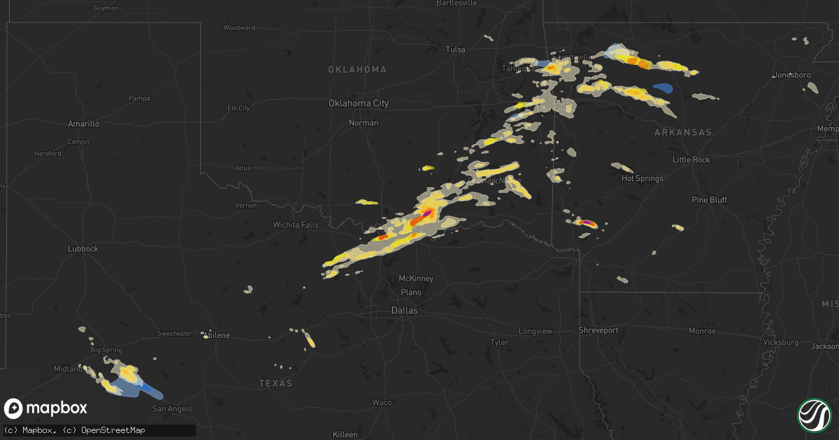
Hail Map on September 23, 2025
Get this storm
September 23 map
$229
one time, instant access
Download today. No call, no setup
Keep the $229
Bought the map and want the full workflow? Apply the entire $229 to a subscription within 7 days. None of it is wasted.
Every map, not just this one
This buys you this map. Subscription and you get every map we run, in the markets you choose from a few cities to whole states to nationwide. Plus real-time alerts the moment a storm fires.
Contact data
Name, contact info, occupancy, even credit band for addresses in the footprint. You go from where it hit to who to call.
Become the source they trust
Unlimited branding weather history reports on demand. You already have the documented answer ready for the property owner, and you are the one who showed up with it.
Property data and RoofTrace estimates
Pull up any address you have got, its value and the exact code rules for that jurisdiction, straight from One Click Code. Then RoofTrace estimates the squares, pitch, and roof value, priced the way you price.
States Impacted by Hail Map on September 23, 2025
Storm reports
Arkansas
| Date | Description |
|---|---|
| 09/23/20253:46 PM CDT | Corrects previous hail report from 2 sw lincoln. Report relayed through spotter network. |
| 09/23/20251:58 AM CDT | Report from convenience store on southern side of nashville... Ar. |
| 09/23/20251:55 AM CDT | Social media report of golf ball size hail just southwest of nashville... Ar. |
| 09/23/20251:50 AM CDT | Reports of damage to sheds... Outbuildings... And chicken houses... Along with downed trees from arkansas highway 355 to around the mission drive and garner loop areas |
Oklahoma
| Date | Description |
|---|---|
| 09/23/20256:50 PM CDT | Report from mping: half dollar |
| 09/23/20256:46 PM CDT | Report from mping: quarter |
| 09/23/20256:00 PM CDT | Relayed image. Location and time are estimated from radar. |
| 09/23/20255:02 PM CDT | Metal roof blown off hospital and power poles damaged. Photos via amateur radio and media. |
| 09/23/20254:55 PM CDT | Observed by stigler awos. |
| 09/23/20254:55 PM CDT | Corrects previous tstm wnd gst report from 3 nne stigler. Observed by stigler awos. |
| 09/22/20259:45 PM CDT | Delayed report. Four light aircraft were damaged by thunderstorm winds at durant regional airport. Time is estimated by radar. |
| 09/22/20257:22 PM CDT | Wind driven half dollar size hail east of vian on 64. Report via spotter network. |
| 09/22/20257:19 PM CDT | Relayed by emergency management. |
| 09/22/20257:15 PM CDT | Report from mping: tennis ball |
| 09/22/20257:15 PM CDT | Spotter network report. Time estimated from radar. |
| 09/22/20257:08 PM CDT | Relayed by emergency management. |
Texas
| Date | Description |
|---|---|
| 09/23/20256:40 PM CDT | Estimated ping pong ball size hail near lake texoma. |
| 09/23/20256:09 PM CDT | Social media report of 1 inch hail in fruitland... Relayed by emergency management. |
| 09/23/20253:33 AM CDT | A local report indicates 78 MPH wind near 5 W Sterling City |
| 09/22/202511:23 PM CDT | Plains wtm se |
| 09/22/202511:23 PM CDT | Plains wtm severe wind gust of 59 mph at 11:23 pm. |
| 09/22/20259:31 PM CDT | A local report indicates 1.00 inch wind near 1 NNE Denison |
| 09/22/20259:25 PM CDT | Emergency management reported that ping-pong sized hail was falling in ne pottsboro for less than 5 minutes. |
| 09/22/20258:56 PM CDT | Half dollar size hail at 377 and ferguson rd north of whitesboro. |
| 09/22/20258:55 PM CDT | A local report indicates 2.00 inch wind near Whitesboro |
| 09/22/20258:52 PM CDT | Quarter size hail in whitesboro. |
Florida
| Date | Description |
|---|---|
| 09/23/20255:10 PM CDT | Storm spotter reported 60-70 mph wind gusts and penny sized hail in apopka near route 441... Route 436... And main street. |
| 09/23/20255:07 PM CDT | Elevated site mesonet station xpeg port everglades reported a wind gust of 58mph as a localized strong downburst occurred just east of port everglades. Site elevation i |
| 09/23/202510:55 AM CDT | Broken tree limbs and branches at a home in the hammocks near sw 147 avenue and n. Kendall drive. Time is estimated based on radar indicated wind gusts near the surface |
Missouri
| Date | Description |
|---|---|
| 09/22/20259:01 PM CDT | High winds torn the metal roof off of a hay barn and knocked a large limb out of a tree. |
| 09/22/20259:00 PM CDT | Trees snapped at the base and mid trunk... Sheet metal barn roof blown off. Time estimated from radar. |
| 09/22/20258:30 PM CDT | Tree down at 545 red top rd. |
| 09/22/20258:16 PM CDT | Trees uprooted/snapped. Shed and playhouse blown away. Time estimated from radar. |
New Mexico
| Date | Description |
|---|---|
| 09/23/20256:45 PM CDT | 60.2 mph gust recorded with personal weather station at lakeshore highlands... Relayed via social media. |
| 09/22/20258:20 PM CDT | Ambient weather network station casa cats purr. |
Cities Impacted by Hail Map on September 23, 2025
- Wellington, KS
- Oxford, KS
- Belle Plaine, KS
- Mulvane, KS
- Udall, KS
- Winfield, KS
- Burden, KS
- Rock, KS
- Montreal, MO
- Camdenton, MO
- Cambridge, KS
- Grenola, KS
- Moline, KS
- Elk Falls, KS
- Howard, KS
- Green Forest, AR
- Berryville, AR
- Huntsville, AR
- Compton, AR
- Kingston, AR
- Alpena, AR
- Harrison, AR
- Jasper, AR
- Ponca, AR
- Marble Falls, AR
- Parthenon, AR
- Wesley, AR
- Elkins, AR
- Vendor, AR
- Hasty, AR
- Mount Judea, AR
- Western Grove, AR
- Hindsville, AR
- Combs, AR
- Saint Joe, AR
- Witter, AR
- Peach Orchard, AR
- Marshall, AR
- Ozark, AR
- Pettigrew, AR
- Saint Paul, AR
- Tahlequah, OK
- Gilbert, AR
- Oark, AR
- Marmaduke, AR
- Lafe, AR
- Knobel, AR
- Healdton, OK
- Wilson, OK
- Ringling, OK
- Hulbert, OK
- Proctor, OK
- Leslie, AR
- Timbo, AR
- Stilwell, OK
- Onia, AR
- Westville, OK
- Prairie Grove, AR
- Lincoln, AR
- Welling, OK
- Park Hill, OK
- Farmington, AR
- Fayetteville, AR
- Canehill, AR
- Summers, AR
- Dover, AR
- Hagarville, AR
- Lone Grove, OK
- West Fork, AR
- Lexington, TN
- Huron, TN
- Ardmore, OK
- Jacksboro, TX
- Winslow, AR
- Fox, AR
- Mountain View, AR
- Reagan, TN
- Morrow, AR
- Hector, AR
- Tilly, AR
- Clinton, AR
- Jerusalem, AR
- Labelle, FL
- Pelsor, AR
- Cash, AR
- Clarksville, AR
- Ozone, AR
- Sallisaw, OK
- Vian, OK
- Scotts Hill, TN
- Evansville, AR
- Scotland, AR
- Stonewall, OK
- Tupelo, OK
- Stigler, OK
- Decaturville, TN
- Keota, OK
- Muldrow, OK
- Mcalester, OK
- Stuart, OK
- Polk City, FL
- Natural Dam, AR
- Lakeland, FL
- Bunch, OK
- Mountainburg, AR
- Centrahoma, OK
- Alvord, TX
- Sunset, TX
- Kiowa, OK
- Harriet, AR
- Wilburton, OK
- Hartshorne, OK
- Cedarville, AR
- Mccurtain, OK
- Bowie, TX
- Calvin, OK
- Red Oak, OK
- Linden, TN
- Forestburg, TX
- Decatur, TX
- Kinta, OK
- Blanco, OK
- Van Buren, AR
- Uniontown, AR
- Gans, OK
- Chester, AR
- Rudy, AR
- Higden, AR
- Fairfield Bay, AR
- Bokoshe, OK
- Chico, TX
- Muenster, TX
- Gainesville, TX
- Roland, OK
- Truth Or Consequences, NM
- Elephant Butte, NM
- Rosston, TX
- Era, TX
- Pittsburg, OK
- Mulberry, AR
- Saint Jo, TX
- Valley View, TX
- Throckmorton, TX
- Lindsay, TX
- Madill, OK
- Durant, OK
- Mead, OK
- Atoka, OK
- Alma, AR
- Quitman, AR
- Heber Springs, AR
- Edgemont, AR
- Drasco, AR
- Fort Smith, AR
- Claremore, OK
- Pryor, OK
- Thackerville, OK
- Tumbling Shoals, AR
- Cleveland, AR
- Whitesboro, TX
- Clifton, TN
- Dyer, AR
- Lavaca, AR
- Wilburn, AR
- Gordonville, TX
- Kingston, OK
- Williamsburg, NM
- Montague, TX
- Hohenwald, TN
- Marietta, OK
- Barling, AR
- Shady Point, OK
- Denison, TX
- Pottsboro, TX
- Siloam Springs, AR
- Springdale, AR
- Cameron, OK
- Merkel, TX
- Caney, OK
- Caddo, OK
- Wister, OK
- Tye, TX
- Quinton, OK
- Atkins, AR
- Sadler, TX
- Charleston, AR
- Caballo, NM
- Tularosa, NM
- Calera, OK
- Cartwright, OK
- Waynesboro, TN
- Poteau, OK
- Abilene, TX
- Hattieville, AR
- Center Ridge, AR
- Tishomingo, OK
- Kenefic, OK
- Coleman, OK
- Milburn, OK
- Porum, OK
- Jonesboro, AR
- Lebanon, OK
- Howe, OK
- Bridgeport, TX
- Hackett, AR
- Spiro, OK
- Springfield, AR
- Heavener, OK
- Lawrenceburg, TN
- Summertown, TN
- Antlers, OK
- Mingus, TX
- Ranger, TX
- Nashoba, OK
- Mansfield, AR
- Hartford, AR
- Trumann, AR
- Coalgate, OK
- Waldron, AR
- Clayton, OK
- Marked Tree, AR
- Lepanto, AR
- Caraway, AR
- Ethridge, TN
- Stringtown, OK
- Cisco, TX
- Rattan, OK
- Eastland, TX
- Mount Pleasant, TN
- Gordon, TX
- Wapanucka, OK
- Lane, OK
- Gore, OK
- Broken Bow, OK
- Stephenville, TX
- Daisy, OK
- Smithville, OK
- Hatfield, AR
- Atoka, TN
- Arlington, TN
- Brighton, TN
- Mena, AR
- Snow, OK
- Alamogordo, NM
- Cloudcroft, NM
- Sherman, TX
- Mason, TN
- Talihina, OK
- Honobia, OK
- Albion, OK
- Valliant, OK
- Cordova, TN
- Memphis, TN
- Cove, AR
- Krebs, OK
- Collierville, TN
- Eads, TN
- Howe, TX
- Comanche, TX
- Colbert, OK
- Bokchito, OK
- Hendrix, OK
- Bennington, OK
- Collinsville, TX
- Moyers, OK
- San Jon, NM
- Bard, NM
- Ravenna, TX
- Boswell, OK
- Adrian, TX
- Telephone, TX
- Hodgen, OK
- Tuskahoma, OK
- Story, AR
- Mount Ida, AR
- Jessieville, AR
- Royal, AR
- De Queen, AR
- Lockesburg, AR
- Horatio, AR
- Nashville, AR
- Mineral Springs, AR
- Hugo, OK
- Soper, OK
- Tarzan, TX
- Lamesa, TX
- Ackerly, TX
- Lenorah, TX
- Ozan, AR
- Stanton, TX
- Knott, TX
- Spencerville, OK
- Midland, TX
- Garden City, TX
- Big Spring, TX
- Saratoga, AR
- Sterling City, TX
- Fordyce, AR
- McCaskill, AR
- Greenbrier, AR
- Ida, AR
- Bath Springs, TN
- Carlsbad, TX
- Robert Lee, TX
- San Angelo, TX
- Ashdown, AR
- Camden, AR
- Stamps, AR
- Taylor, AR
- Magnolia, AR