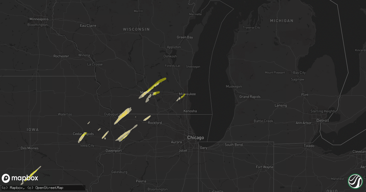
Hail Map on November 4, 2022
Get this storm
November 4 map
$229
one time, instant access
Download today. No call, no setup
Keep the $229
Bought the map and want the full workflow? Apply the entire $229 to a subscription within 7 days. None of it is wasted.
Every map, not just this one
This buys you this map. Subscription and you get every map we run, in the markets you choose from a few cities to whole states to nationwide. Plus real-time alerts the moment a storm fires.
Contact data
Name, contact info, occupancy, even credit band for addresses in the footprint. You go from where it hit to who to call.
Become the source they trust
Unlimited branding weather history reports on demand. You already have the documented answer ready for the property owner, and you are the one who showed up with it.
Property data and RoofTrace estimates
Pull up any address you have got, its value and the exact code rules for that jurisdiction, straight from One Click Code. Then RoofTrace estimates the squares, pitch, and roof value, priced the way you price.
States Impacted by Hail Map on November 4, 2022
Storm reports
Kansas
| Date | Description |
|---|---|
| 11/04/20226:22 PM CDT | Delayed report. Time estimated by radar. |
| 11/04/20221:18 AM CDT | At 618 PM CDT, a severe thunderstorm was located over Chetopa, moving northeast at 75 mph. HAZARD...Quarter size hail. SOURCE...Radar indicated. IMPACT...Damage to vehicles is expected. Locations impacted include... Sherman, West Mineral, Faulkner and Hallowell. |
| 11/04/20221:15 AM CDT | At 615 PM CDT, a severe thunderstorm was located 6 miles southwest of Chetopa, moving north at 70 mph. HAZARD...Quarter size hail. SOURCE...Radar indicated. IMPACT...Damage to vehicles is expected. Locations impacted include... Oswego and Chetopa. |
Iowa
| Date | Description |
|---|---|
| 11/04/202212:46 PM CDT | Davis weather station reported a wind gust of 64 mph at 11:46am... This matches perfectly with the radar occurring at 12:46pm. Have adjusted the time to match radar as |
| 11/04/202212:20 PM CDT | From facebook. |
| 11/04/202212:15 PM CDT | Facebook report of quarters near kirkwood college. |
| 11/04/202210:38 AM CDT | Dime to quarter size hail reported. |
| 11/04/202210:35 AM CDT | A local report indicates 1.00 inch wind near 3 W CLINTON |
| 11/04/20227:43 AM CDT | At 1243 PM CDT, a severe thunderstorm was located over Stanwood, moving east at 50 mph. HAZARD...60 mph wind gusts. SOURCE...Radar indicated. IMPACT...Expect damage to roofs, siding, and trees. This severe thunderstorm will be near... Oxford Mills around 1255 PM CDT. Lowden, Oxford Junction, Toronto and Massillon Park around 100 PM CDT.Other locations in the path of this severe thunderstorm includeWheatland, Lost Nation, Walnut Grove Park and Calamus. |
| 11/04/20227:11 AM CDT | At 1210 PM CDT, a severe thunderstorm was located over Swisher, or 7 miles south of Cedar Rapids, moving northeast at 55 mph. HAZARD...60 mph wind gusts and quarter size hail. SOURCE...Radar indicated. IMPACT...Hail damage to vehicles is expected. Expect wind damage to roofs, siding, and trees. Locations impacted include... Cedar Rapids, Iowa City, Marion, Coralville, North Liberty, Mount Vernon, Lisbon, Fairfax, Solon, Tiffin, Ely, Walford, Springville, Swisher, Oxford, Shueyville, Bertram, Martelle, Oakdale and Lake Macbride State Park. |
| 11/04/20223:01 AM CDT | At 800 AM CDT, a severe thunderstorm was located near Chariton Municipal Airport, or 5 miles southwest of Chariton, moving northeast at 55 mph. HAZARD...60 mph wind gusts and quarter size hail. SOURCE...Radar indicated. IMPACT...Hail damage to vehicles is expected. Expect wind damage to roofs, siding, and trees. This severe thunderstorm will be near... Chariton and Red Haw Lake State Park around 805 AM CDT. Russell and Williamson around 810 AM CDT.Other locations in the path of this severe thunderstorm includeLovilia, Hamilton, Marysville, Bussey, Harvey and Pella MunicipalAirport. |
| 11/04/20222:39 AM CDT | At 738 AM CDT, a severe thunderstorm was located near Garden Grove, or 6 miles northeast of Leon, moving northeast at 55 mph. HAZARD...60 mph wind gusts and quarter size hail. SOURCE...Radar indicated. IMPACT...Hail damage to vehicles is expected. Expect wind damage to roofs, siding, and trees. This severe thunderstorm will be near... Le Roy around 745 AM CDT. Humeston around 750 AM CDT. Derby around 755 AM CDT.Other locations in the path of this severe thunderstorm includeLucas, Chariton, Red Haw Lake State Park and Chariton MunicipalAirport. |
Arkansas
| Date | Description |
|---|---|
| 11/04/20226:57 PM CDT | Tornadic debris signature from ksrx. |
| 11/04/20226:57 PM CDT | Trees and power poles downed. |
| 11/04/20226:57 PM CDT | Tornadic debris signature from ksrx. |
| 11/04/20226:55 PM CDT | Damage to the roof of a chicken house and trees down. |
| 11/04/20226:44 AM CDT | At 1143 PM CDT, a severe thunderstorm was located near Pine Bluff Arsenal, or 9 miles north of Pine Bluff, moving east at 50 mph. HAZARD...60 mph wind gusts. SOURCE...Radar indicated. IMPACT...Expect damage to roofs, siding, and trees. Locations impacted include... Pine Bluff... Stuttgart... Lonoke... Clarendon... Hazen... De Valls Bluff... England... Carlisle... Altheimer... Humphrey... Fredonia... Humnoke... Almyra... Ulm... Roe... Barrettsville... Allendale... Dobbs Landing... McCreanor... Stuttgart Municipal Airport... |
| 11/04/20226:43 AM CDT | At 1143 PM CDT, severe thunderstorms were located along a line extending from 10 miles east of Junction City to Bernice to near Arcadia, moving east at 20 mph. HAZARD...60 mph wind gusts. SOURCE...Radar indicated. IMPACT...Expect damage to roofs, siding, and trees. Locations impacted include... Ruston, Grambling, Farmerville, Bernice, Cooley, Dubach, Choudrant, Simsboro, Marion, Vienna, Downsville, Spearsville, Lillie, D Arbonne, Mount Zion, Oakland, Taylorville, Bayou D Arbonne Lake, Cecil and Shiloh. |
| 11/04/20226:37 AM CDT | At 1137 PM CDT, severe thunderstorms were located along a line extending from 6 miles south of Gravel Hill to Beebe to near Sylvania, moving northeast at 65 mph. HAZARD...60 mph wind gusts. SOURCE...Radar indicated. IMPACT...Expect damage to roofs, siding, and trees. Locations impacted include... Cabot... Searcy... Lonoke... Augusta... Des Arc... Beebe... Ward... Bald Knob... Austin in Lonoke County... Judsonia... Kensett... Higginson... Patterson... Russell... West Point... Tupelo... Old Austin... Crosby... Meto... Thurman... |
| 11/04/20226:30 AM CDT | At 1129 PM CDT, severe thunderstorms were located along a line extending from 8 miles southeast of Carthage to 6 miles north of Calion, moving east at 15 mph. HAZARD...60 mph wind gusts and penny size hail. SOURCE...Radar indicated. IMPACT...Expect damage to roofs, siding, and trees. Locations impacted include... Pine Bluff... Warren... Fordyce... Rison... Hampton... Hermitage... Kingsland... Thornton... Harrell... Ingalls... Ellisville... Hilo... Lamont... Hampton Municipal Airport... Hebron... Moro Bay... Kedron... Weeks... Mt Elba... Moro Bay State Park... |
| 11/04/20226:05 AM CDT | At 1104 PM CDT, a severe thunderstorm was located near Pine Bluff Arsenal, or 11 miles east of Sheridan, moving east at 45 mph. HAZARD...60 mph wind gusts. SOURCE...Radar indicated. IMPACT...Expect damage to roofs, siding, and trees. Locations impacted include... Pine Bluff... Stuttgart... White Hall... England... Wrightsville... Redfield... Altheimer... Humphrey... Humnoke... Almyra... Keo... Estes... Orion... Stuttgart Municipal Airport... Hensley Island... Brummitt... Pine Bluff Arsenal... Parkers Corner... Madding... Warbritton... |
| 11/04/20226:05 AM CDT | At 1105 PM CDT, severe thunderstorms were located along a line extending from Highland Industrial Park to near Lisbon to 9 miles northeast of Homer, moving east at 45 mph. HAZARD...60 mph wind gusts. SOURCE...Radar indicated. IMPACT...Expect damage to roofs, siding, and trees. Locations impacted include... El Dorado, Smackover, Norphlet, Huttig, Junction City, Strong, Calion, Wesson, Lisbon, Urbana, Lawson, Lapile, Moro Bay State Park, Felsenthal, Newell, New London, Pigeon Hill, Kenova, Catesville and Hew Hope. |
| 11/04/20226:02 AM CDT | At 1102 PM CDT, severe thunderstorms were located along a line extending from near Mountain View to near Heber Springs to near Pickles Gap, moving east at 65 mph. HAZARD...60 mph wind gusts. SOURCE...Radar indicated. IMPACT...Expect damage to roofs, siding, and trees. Locations impacted include... Batesville... Newport... Heber Springs... Mountain View... Black Rock... Lake Charles State Park... Bald Knob... Cave City... Tuckerman... Diaz... Newark... Greers Ferry... Quitman... Imboden... Pangburn... Rose Bud... Cushman... Mount Pleasant... Pleasant Plains... Enola... |
| 11/04/20225:57 AM CDT | At 1057 PM CDT, severe thunderstorms were located along a line extending from near Maumelle to West Little Rock to near Benton, moving east at 40 mph. HAZARD...60 mph wind gusts. SOURCE...Radar indicated. IMPACT...Expect damage to roofs, siding, and trees. Locations impacted include... Little Rock... North Little Rock... Conway... Sherwood... Jacksonville... Cabot... West Little Rock... Maumelle... Bryant... Downtown Little Rock... Lonoke... North Little Rock Airport... Little Rock AFB... Southwest Little Rock... Beebe... Ward... Vilonia... Shannon Hills... Mayflower... Wrightsville... |
| 11/04/20225:30 AM CDT | At 1030 PM CDT, severe thunderstorms were located along a line extending from near Shongaloo to near Haughton, moving east at 25 mph. HAZARD...60 mph wind gusts. SOURCE...Radar indicated. IMPACT...Expect damage to roofs, siding, and trees. Locations impacted include... Bossier City, Minden, Homer, Haughton, Haynesville, Sibley, Cotton Valley, Gibsland, Sarepta, Doyline, Dubberly, Dixie Inn, Shongaloo, Eastwood, Evergreen, Athens, Lisbon, Mount Lebanon, Leton and Fillmore. |
| 11/04/20225:23 AM CDT | At 1023 PM CDT, a severe thunderstorm was located 12 miles west of Leola, or 15 miles east of Arkadelphia, moving northeast at 65 mph. HAZARD...60 mph wind gusts and nickel size hail. SOURCE...Radar indicated. IMPACT...Expect damage to roofs, siding, and trees. Locations impacted include... Little Rock... Benton... Bryant... Malvern... Sheridan... Haskell... Shannon Hills... Rockport... Caddo Valley... Traskwood... Leola... Tull... Sparkman... Carthage... Prattsville... Poyen... Perla... Cane Creek... Jenkins Ferry State Park... East End... |
| 11/04/20225:20 AM CDT | At 1020 PM CDT, severe thunderstorms were located along a line extending from near Watts to Hill Creek, moving northeast at 55 mph. HAZARD...60 mph wind gusts and penny size hail. SOURCE...Radar indicated. IMPACT...Expect damage to roofs, siding, and trees. Locations impacted include... Heber Springs... Mountain View... Clinton... Fairfield Bay... Marshall... Greenbrier... Calico Rock... Greers Ferry... Wooster... Quitman... Guy... Rose Bud... Damascus... Twin Groves... Menifee... Shirley... Pineville... Higden... Bethlehem... Hill Creek... |
| 11/04/20225:18 AM CDT | At 1017 PM CDT, severe thunderstorms were located along a line extending from 8 miles southwest of Williams Junction to Lonsdale to 8 miles east of Hot Springs, moving northeast at 45 mph. HAZARD...60 mph wind gusts and quarter size hail. SOURCE...Radar indicated. IMPACT...Hail damage to vehicles is expected. Expect wind damage to roofs, siding, and trees. Locations impacted include... Little Rock... North Little Rock... Conway... Benton... West Little Rock... Maumelle... Bryant... Hot Springs Village... Perryville... Southwest Little Rock... Greenbrier... Haskell... Shannon Hills... Mayflower... Wooster... Oppelo... Traskwood... Menifee... Perry... Adona... |
| 11/04/20224:40 AM CDT | At 940 PM CDT, a severe thunderstorm was located over Emmet, or 8 miles south of Prescott, moving northeast at 60 mph. HAZARD...60 mph wind gusts and nickel size hail. SOURCE...Radar indicated. IMPACT...Expect damage to roofs, siding, and trees. Locations impacted include... Arkadelphia... Gurdon... Caddo Valley... Sparkman... Chidester... Okolona... Whelen Springs... Beirne... Gum Springs in Clark County... Richwoods... White Oak Lake State Park... Donaldson... Friendship... Tulip... Curtis... Ouachita... Reader... Vaden... Dalark... Midway in Hot Spring County... |
| 11/04/20224:38 AM CDT | At 937 PM CDT, severe thunderstorms were located along a line extending from near Okolona to near Prescott to Bodcaw, moving northeast at 45 mph. HAZARD...60 mph wind gusts and quarter size hail. SOURCE...Radar indicated. IMPACT...Hail damage to vehicles is expected. Expect wind damage to roofs, siding, and trees. Locations impacted include... Prescott, Emmet, Rosston, Willisville, Bodcaw, Bluff City, White Oak Lake State Park, Cale, Young, Sutton, Waterloo, Falcon, Boughton, Mount Moriah, Morris, Laneburg and Reader. |
| 11/04/20224:33 AM CDT | At 932 PM CDT, severe thunderstorms were located along a line extending from Lake Dardanelle to north of Hollis, moving northeast at 55 mph. HAZARD...60 mph wind gusts and penny size hail. SOURCE...Radar indicated. IMPACT...Expect damage to roofs, siding, and trees. Locations impacted include... Russellville... Morrilton... Clinton... Perryville... Dardanelle... Atkins... Pottsville... Dover... London... Oppelo... Hector... Perry... Adona... Sequoya Park... Lake Dardanelle State Park... Happy Bend... Dabney... Hattieville... Jerusalem... Blick... |
| 11/04/20224:11 AM CDT | At 911 PM CDT, a severe thunderstorm was located 8 miles west of Lake Ouachita State Park, or 17 miles northwest of Hot Springs, moving northeast at 35 mph. HAZARD...60 mph wind gusts and quarter size hail. SOURCE...Radar indicated. IMPACT...Hail damage to vehicles is expected. Expect wind damage to roofs, siding, and trees. Locations impacted include... Jessieville... Lake Ouachita State Park... Avant... Lena Landing Rec Area... Hamilton... Crystal Springs Landing... Mt Tabor... Hollis... Crystal Springs... |
| 11/04/20223:29 AM CDT | At 828 PM CDT, a severe thunderstorm was located over Upper Buffalo Wilderness Area, or 13 miles southwest of Jasper, moving northeast at 40 mph. HAZARD...60 mph wind gusts and quarter size hail. SOURCE...Radar indicated. IMPACT...Hail damage to vehicles is expected. Expect wind damage to roofs, siding, and trees. Locations impacted include... Jasper... Western Grove... Valley Springs... Dugger... Carver... Erbie... Upper Buffalo Wilderness Area... Lost Valley State Park... Piercetown... Pruitt... Crawford... Everton... St. Joe... Pindall... Marble Falls... Yardelle... Swain... Gum Springs in Newton County... Eros... Bruno... |
| 11/04/20223:27 AM CDT | At 826 PM CDT, severe thunderstorms were located along a line extending from near Rosetta to 9 miles northwest of Broomfield to near Holman, moving northeast at 50 mph. HAZARD...60 mph wind gusts. SOURCE...Radar indicated. IMPACT...Expect damage to roofs, siding, and trees. Locations impacted include... Marshall... Lamar... Dover... Knoxville... Hector... Marsena... Witts Spring... Rocky Hill... Moore... Duff... Dabney... Point Peter... Bohannon... Imo... Elberta... Watts... Holman... Rosetta... Kay... Dillen... |
| 11/04/20221:55 AM CDT | At 654 PM CDT, severe thunderstorms were located along a line extending from 4 miles north of Brentwood to 5 miles southeast of Winslow to near Dyer, moving northeast at 65 mph. HAZARD...60 mph wind gusts. SOURCE...Radar indicated. IMPACT...Expect damage to roofs, siding, and trees. Locations in or near the path include... Ozark... Huntsville... Mountainburg... Elkins... West Fork... Mulberry... Dyer... Winslow... Chester... St. Paul... Wesley... Rudd... Saint Paul... Aurora... Boston... Withrow Springs State Park... Brentwood... Lake Fort Smith... Marble... Cass...This includes the following highways, Interstate 40 in Arkansas between mile markers 15 and 34. Interstate 49 between mile markers 29 and 44, and between milemarkers 46 and 48. |
| 11/03/202211:50 PM CDT | At 450 PM CDT, a severe thunderstorm was located 5 miles east of Keota, moving northeast at 40 mph. HAZARD...60 mph wind gusts. SOURCE...Radar indicated. IMPACT...Expect damage to roofs, siding, and trees. Locations in or near the path include... Muldrow... Roland... Keota... Bokoshe... Gans... Cowlington... Cottonwood... Dora...This includes Interstate 40 in Oklahoma between mile markers 310 and328. |
| 11/03/202211:44 PM CDT | Tree reported blown down in furlow. |
| 11/03/202211:35 PM CDT | Several large tree limbs were snapped off in the area. |
| 11/03/202211:30 PM CDT | Trees down in cabot. |
| 11/03/202211:27 PM CDT | Part of a metal roof covering a porch was peeled back. |
| 11/03/202211:10 PM CDT | Several large tree limbs were snapped off... Resulting in isolated power outages. |
| 11/03/202211:06 PM CDT | Multiple trees and powelines down on east sardis road. Structues damaged... Possible tornado. |
| 11/03/202211:04 PM CDT | Nws survey revealed an ef2 tornado southeast of sardis. This tornado started on cardinal circle... Uprooting or snapping trees as it moved northeast over west fairview |
| 11/03/202210:01 PM CDT | Nws survey revealed an ef1 tornado southeast of curtis. This tornado started just southwest of vaden road... Continuing northeast across 2nd road towards newton and cop |
| 11/03/20229:58 PM CDT | Trees and powerlines down. |
| 11/03/20229:49 PM CDT | The tornado began along little texas road south of hwy 28 in yell county. Several pine and hardwood trees were either snapped or uprooted along little texas road and bi |
| 11/03/20229:34 PM CDT | Numerous trees were blown down throughout the county. Downed trees temporarily blocked hwy 62 east... Hwy 5 south... And hwy 178 west... As well as numerous county road |
| 11/03/20229:15 PM CDT | Several chicken houses and barns sustained damage. A number of trees were also blown down. Time was estimated by radar. |
| 11/03/20228:56 PM CDT | Tractor trailer overturned on i-30 bridge over the red river in fulton... Arkansas blocking both east and westbound lanes. |
| 11/03/20228:44 PM CDT | The roof of a vacant house located on lake norfork drive collapsed. A collapsed roof at an outdoor boat storage business located on hwy 62 east resulted damage to sever |
| 11/03/20228:43 PM CDT | This brief tornado developed along a strong rear flank downdraft surge that swept across areas immediately southeast of wickes... Ar. Several chicken houses immediately |
| 11/03/20228:32 PM CDT | At least two homes received damage... One with extensive roof damage... Located on hwy. 26 near the possum hollow road intersection. The other home damage was near hwy. |
| 11/03/20228:22 PM CDT | Trees and powelones down in pine ridge. |
| 11/03/20228:19 PM CDT | Trees and powerlines down in amity. |
| 11/03/20228:17 PM CDT | Trees and powerlines down in cherry hill. |
| 11/03/20228:07 PM CDT | A few trees were blown down. This is a delayed report. |
| 11/03/20228:06 PM CDT | Trees and powerlines down in kirby. |
| 11/03/20228:03 PM CDT | Trees and powerlines down across arkansas 14. |
| 11/03/20227:46 PM CDT | Tornadic debris signature from ksrx. |
| 11/03/20227:45 PM CDT | Trees and power poles downed. Damage to the roof of a grocery store. |
| 11/03/20227:44 PM CDT | Report of a tree downed across hwy 23... South of hwy 288 intersection. Also took down a power line. *possible tornado*. |
| 11/03/20227:41 PM CDT | Trees and powerlines down in wickes. |
| 11/03/20227:41 PM CDT | Local coordinator reported four chicken houses and twelve homes damaged in the wickes area. |
| 11/03/20227:24 PM CDT | Tornadic debris signature from ksrx. |
Texas
| Date | Description |
|---|---|
| 11/04/20226:51 PM CDT | Significant damage. |
| 11/04/20226:48 PM CDT | Considerable trees uprooted and or snapped across rural county roads to the west and northwest of daingerfield. Tornado debris signature correlates to the damage across |
| 11/04/20226:26 PM CDT | Tree snapped in half... Many power poles down. |
| 11/04/20226:20 PM CDT | Widespread trees uprooted and/or snapped across county roads to the west and north of clarksville... Texas. Storm spotters confirmation of damage caused by a tornado. |
| 11/04/20226:08 PM CDT | Possible tornado damage north of athens. |
| 11/04/20225:55 PM CDT | Reports of trees down around hawkins. |
| 11/04/20225:20 PM CDT | Several reports of a tornado moving toward i-30 near sulphur springs... Tx. |
| 11/04/20225:10 PM CDT | Golf ball size hail reported. |
| 11/04/20225:05 PM CDT | Delayed report: 2 to 2.75 inch size hail fell in point... Tx. |
| 11/04/20224:48 PM CDT | Quarter sized hail reported between quinlan and west tawakoni. |
| 11/04/20224:25 PM CDT | Quarter sized hail reported. |
| 11/04/20224:19 PM CDT | Multiple social media reports of a tornado on the ground near brookston... Tx. |
| 11/04/20224:12 PM CDT | Power poles down at the intersection of 380e and magnolia with a nearby gust measurement of 54 mph. |
| 11/04/20224:07 PM CDT | 55 knot wind gust measured at dfw asos. |
| 11/04/20223:48 PM CDT | 4 inch tree branches downed on foutch road. |
| 11/04/20222:50 PM CDT | Golf ball sized hail reported. |
| 11/04/20222:25 PM CDT | A local report indicates 1.00 inch wind near ARCHER CITY |
| 11/04/20222:24 PM CDT | Measurement from mesonet of 61 mph. |
| 11/04/20221:22 PM CDT | Brief quarter inch hail. |
| 11/04/20221:15 PM CDT | Report of 1 inch hail. |
| 11/04/20221:11 PM CDT | Occasional quarter size hail. |
| 11/04/20226:52 AM CDT | At 1152 AM CDT, a severe thunderstorm was located 5 miles northwest of Odell, moving northeast at 55 mph. HAZARD...Quarter size hail. SOURCE...Radar indicated. IMPACT...Damage to vehicles is expected. Locations impacted include... Altus, Olustee, Martha, Elmer, Headrick, Friendship, Altus Air Force Base, Humphreys and Odell. |
| 11/04/20225:20 AM CDT | At 1019 PM CDT, a severe thunderstorm was located over Rockland, moving northeast at 40 mph. HAZARD...60 mph wind gusts and penny size hail. SOURCE...Radar indicated. IMPACT...Expect damage to roofs, siding, and trees. Locations impacted include... Rockland. |
| 11/04/20225:12 AM CDT | At 1012 PM CDT, severe thunderstorms were located along a line extending from near Shreveport to near Joaquin, moving east at 10 mph. HAZARD...60 mph wind gusts. SOURCE...Radar indicated. IMPACT...Expect damage to roofs, siding, and trees. Locations impacted include... Shreveport, Bossier City, Mansfield, Stonewall, Logansport, Joaquin, South Mansfield, Keachi, Grand Cane, Longstreet, Stanley, Keat Chie, Carmel, Curtis, Grand Bayou, Kingston, Plum Orchard Landing, Loggy Bayou, Koran and Ninock. |
| 11/04/20224:44 AM CDT | At 943 PM CDT, a severe thunderstorm was located near Alabama-Coushatta Reservation, or 11 miles west of Woodville, moving northeast at 35 mph. HAZARD...60 mph wind gusts and penny size hail. SOURCE...Radar indicated. IMPACT...Expect damage to roofs, siding, and trees. Locations impacted include... Woodville, Colmesneil and Chester. |
| 11/04/20224:40 AM CDT | At 940 PM CDT, a severe thunderstorm was located near Alabama-Coushatta Reservation, or 13 miles west of Woodville, moving northeast at 40 mph. HAZARD...60 mph wind gusts and penny size hail. SOURCE...Radar indicated. IMPACT...Expect damage to roofs, siding, and trees. Locations impacted include... Alabama-Coushatta Reservation. |
| 11/04/20224:11 AM CDT | At 911 PM CDT, a severe thunderstorm was located 7 miles northwest of Elysian Fields, or 8 miles southeast of Marshall, moving northeast at 40 mph. HAZARD...70 mph wind gusts and quarter size hail. SOURCE...Radar indicated. IMPACT...Hail damage to vehicles is expected. Expect considerable tree damage. Wind damage is also likely to mobile homes, roofs, and outbuildings. Locations impacted include... Shreveport, Marshall, Greenwood, Blanchard, Waskom, Oil City, Mooringsport, Belcher, Elysian Fields, Scottsville, Dixie, Caddo Lake, Cross Lake, Cavett, Leigh, Jonesville and Bethany. |
| 11/04/20223:40 AM CDT | At 840 PM CDT, severe thunderstorms were located along a line extending from near Mandeville to near Fouke to Atlanta, moving northeast at 55 mph. HAZARD...70 mph wind gusts and quarter size hail. SOURCE...Radar indicated. IMPACT...Hail damage to vehicles is expected. Expect considerable tree damage. Wind damage is also likely to mobile homes, roofs, and outbuildings. Locations impacted include... Texarkana, Magnolia, Hope, Atlanta, Prescott, Stamps, Waldo, Lewisville, McNeil, Queen City, Fouke, Emmet, Buckner, Perrytown, Rosston, Garland, Fulton, Ogden, Willisville and Bodcaw. |
| 11/04/20223:40 AM CDT | At 840 PM CDT, severe thunderstorms were located along a line extending from near Fentress to near New Berlin, moving northeast at 25 mph. HAZARD...60 mph wind gusts and quarter size hail. SOURCE...Radar indicated. IMPACT...Hail damage to vehicles is expected. Expect wind damage to roofs, siding, and trees. Locations impacted include... Seguin, Lockhart, Luling, Martindale, Kingsbury, Staples, Fentress, Palmeto State Park, Geronimo, Brownsboro, Tilmon, Joliet, Oak Forest, Stairtown, Belmont, McNeil, McMahan, Ottine, Monthalia and Taylorsville. |
| 11/04/20223:36 AM CDT | At 836 PM CDT, a severe thunderstorm was located near Cedar Creek, or 7 miles southwest of Bastrop, moving east at 45 mph. HAZARD...60 mph wind gusts and quarter size hail. SOURCE...Radar indicated. IMPACT...Hail damage to vehicles is expected. Expect wind damage to roofs, siding, and trees. Locations impacted include... Bastrop, Giddings, Smithville, Fedor, Paige, Camp Swift, Circle D-KC Estates, Cedar Creek, Wyldwood, Upton, Phelan, Bastrop State Park, Hills Prairie, Northrup, Rockne, Watterson, Buescher State Park, Hills, Lincoln and Nechanitz. |
| 11/04/20222:54 AM CDT | At 754 PM CDT, a severe thunderstorm was located near Uhland, or near Kyle, moving east at 35 mph. HAZARD...60 mph wind gusts and quarter size hail. SOURCE...Radar indicated. IMPACT...Hail damage to vehicles is expected. Expect wind damage to roofs, siding, and trees. Locations impacted include... San Marcos, Kyle, Lockhart, Martindale, Uhland, Mustang Ridge, Niederwald, Cedar Creek, Wyldwood, Rosanky, Rockne, Watterson, San Marcos Regional Airport, Maxwell, Reedville, Red Rock, Lytton Springs, Dale, Bateman and St John Colony. |
| 11/04/20221:08 AM CDT | At 608 PM CDT, severe thunderstorms were located along a line extending from near Dodd City to Greenville Club Lake, moving northeast at 50 mph. HAZARD...60 mph wind gusts and quarter size hail. SOURCE...Radar indicated. IMPACT...Hail damage to vehicles is expected. Expect wind damage to roofs, siding, and trees. Locations impacted include... Greenville, Paris, Sulphur Springs, Commerce, Cooper, Honey Grove, Wolfe City, Cumby, Roxton, Campbell, Lake Crook, Cooper Lake, Lake Gibbons, Big Creek Lake, Greenville Club Lake, Cooper Lake State Park, Lake Sulphur Springs, Klondike, Sumner and Greenville City Lakes.This includes Interstate 30 between mile markers 94 and 120. |
| 11/04/202212:24 AM CDT | At 524 PM CDT, severe thunderstorms were located along a line extending from near Lucas to Sunnyvale, moving northeast at 55 mph. HAZARD...65 mph wind gusts and penny size hail. SOURCE...Radar indicated. IMPACT...Expect damage to roofs, siding, and trees. Locations impacted include... Dallas, Plano, Garland, Mesquite, McKinney, Richardson, Allen, Rowlett, Wylie, Rockwall, Greenville, Balch Springs, Sachse, Murphy, Royse City, Fairview, Heath, Princeton, Fate and Lucas.This includes the following highways... Interstate 20 between mile markers 480 and 482. Interstate 30 between mile markers 58 and 100. |
| 11/03/202211:43 PM CDT | At 443 PM CDT, a severe thunderstorm was located near Bremond, or 10 miles southeast of Marlin, moving northeast at 45 mph. HAZARD...60 mph wind gusts and quarter size hail. SOURCE...Radar indicated. IMPACT...Hail damage to vehicles is expected. Expect wind damage to roofs, siding, and trees. Locations impacted include... Groesbeck, Fort Parker State Park, Lake Limestone, Thornton, Kosse, Highbank, Fallon, Box Church and Reagan. |
| 11/03/202211:28 PM CDT | At 427 PM CDT, a severe thunderstorm was located near Terrell, moving northeast at 60 mph. HAZARD...60 mph wind gusts and quarter size hail. SOURCE...Radar indicated. IMPACT...Hail damage to vehicles is expected. Expect wind damage to roofs, siding, and trees. Locations impacted include... Greenville, Terrell, Kaufman, West Tawakoni, Quinlan, East Tawakoni, Point, Cumby, Campbell, Hawk Cove, Grays Prairie, Lake Tawakoni, Greenville Club Lake, Lake Tawakoni State Park, New Terrell City Lake, Elmo, Oak Grove, Lone Oak, Post Oak Bend City and Union Valley.This includes the following highways... Interstate 20 between mile markers 496 and 510. Interstate 30 between mile markers 80 and 87, and between milemarkers 100 and 115. |
| 11/03/202211:20 PM CDT | At 419 PM CDT, a severe thunderstorm was located 11 miles northeast of Honey Grove, moving northeast at 40 mph. HAZARD...60 mph wind gusts and quarter size hail. SOURCE...Radar indicated. IMPACT...Hail damage to vehicles is expected. Expect wind damage to roofs, siding, and trees. Locations in or near the path include... Hugo... Fort Towson... Sawyer... Goodland... Messer... Hugo Lake State Park... Raymond Gary State Park... Grant... Ord... Fallon... Swink... Frogville... Apple... Huskey... Gay... |
| 11/03/202211:01 PM CDT | At 400 PM CDT, a severe thunderstorm was located near Cartwright, moving northeast at 40 mph. HAZARD...60 mph wind gusts and quarter size hail. SOURCE...Radar indicated. IMPACT...Hail damage to vehicles is expected. Expect wind damage to roofs, siding, and trees. Locations impacted include... Durant, Colbert, Caddo, Achille, Silo, Kenefic, Mead, Armstrong, Cartwright, eastern Lake Texoma and Calera. |
| 11/03/202210:50 PM CDT | At 349 PM CDT, severe thunderstorms were located along a line extending from Pilot Point to near Highland Village, moving northeast at 50 mph. HAZARD...60 mph wind gusts and quarter size hail. SOURCE...Radar indicated. IMPACT...Hail damage to vehicles is expected. Expect wind damage to roofs, siding, and trees. Locations impacted include... Plano, McKinney, Carrollton, Frisco, Denton, Richardson, Lewisville, Allen, Flower Mound, Grapevine, Coppell, Sherman, The Colony, Southlake, Corinth, Highland Village, Lake Dallas, Lake Lewisville, Little Elm and Prosper.This includes Interstate 35E between mile markers 446 and 464. |
| 11/03/202210:43 PM CDT | At 343 AM CDT, a severe thunderstorm was located 10 miles south of Wolf Creek Park, or 17 miles northwest of Canadian, moving northeast at 65 mph. HAZARD...60 mph wind gusts and quarter size hail. SOURCE...Radar indicated. IMPACT...Minor damage to roofs, siding, and trees is possible. Hail damage to vehicles is expected. Locations impacted include... Follett, Darrouzett and Wolf Creek Park. |
| 11/03/202210:42 PM CDT | At 342 PM CDT, a severe thunderstorm was located 5 miles east of Marietta, moving northeast at 50 mph. HAZARD...60 mph wind gusts and quarter size hail. SOURCE...Radar indicated. IMPACT...Hail damage to vehicles is expected. Expect wind damage to roofs, siding, and trees. Locations impacted include... Ardmore, Madill, Tishomingo, Marietta, Dickson, Mannsville, Ravia, Mill Creek, Reagan, Lake Murray, Connerville, Lebanon, Russett, western Lake Texoma and Oakland. |
| 11/03/202210:27 PM CDT | At 327 PM CDT, a severe thunderstorm was located near Waxahachie, moving northeast at 50 mph. HAZARD...60 mph wind gusts and quarter size hail. SOURCE...Radar indicated. IMPACT...Hail damage to vehicles is expected. Expect wind damage to roofs, siding, and trees. Locations impacted include... Dallas, Mesquite, Desoto, Cedar Hill, Lancaster, Waxahachie, Balch Springs, Ennis, Midlothian, Seagoville, Forney, Glenn Heights, Red Oak, Hutchins, Sunnyvale, Wilmer, Ovilla, Crandall, Ferris and Palmer.This includes the following highways... Interstate 35E between mile markers 396 and 420. Interstate 20 between mile markers 465 and 492. Interstate 30 between mile markers 51 and 56. Interstate 45 between mile markers 260 and 281. |
| 11/03/202210:20 PM CDT | At 320 PM CDT, severe thunderstorms were located along a line extending from near Roanoke to near Westworth Village, moving northeast at 50 mph. HAZARD...60 mph wind gusts and quarter size hail. SOURCE...Radar indicated. IMPACT...Hail damage to vehicles is expected. Expect wind damage to roofs, siding, and trees. Locations impacted include... Fort Worth, Arlington, Irving, Grand Prairie, Denton, Lewisville, Flower Mound, Euless, Bedford, Grapevine, Haltom City, Keller, Coppell, Hurst, Southlake, Watauga, Colleyville, Benbrook, Corinth and Saginaw.This includes the following highways... Interstate 35 between mile markers 468 and 471. Interstate 35W between mile markers 48 and 85. Interstate 35E between mile markers 448 and 466. Interstate 20 between mile markers 428 and 432. Interstate 30 between mile markers 7 and 24. |
| 11/03/202210:02 PM CDT | At 302 PM CDT, a severe thunderstorm was located near Pecan Plantation, or 10 miles east of Granbury, moving northeast at 55 mph. HAZARD...60 mph wind gusts and quarter size hail. SOURCE...Radar indicated. IMPACT...Hail damage to vehicles is expected. Expect wind damage to roofs, siding, and trees. Locations impacted include... Fort Worth, Arlington, Mansfield, Burleson, Cleburne, Benbrook, Crowley, Forest Hill, Granbury, Kennedale, Everman, Keene, Joshua, Alvarado, Rendon, Pecan Plantation, Edgecliff Village, Pantego, Godley and Cross Timber.This includes the following highways... Interstate 35W between mile markers 24 and 49. Interstate 20 between mile markers 430 and 448. Interstate 30 between mile markers 20 and 26. |
| 11/03/20229:54 PM CDT | At 253 PM CDT, a severe thunderstorm was located 5 miles northeast of Jolly, moving northeast at 60 mph. HAZARD...60 mph wind gusts and quarter size hail. SOURCE...Radar indicated. IMPACT...Hail damage to vehicles is expected. Expect wind damage to roofs, siding, and trees. Locations impacted include... Henrietta, Waurika, Comanche, Ryan, Petrolia, Byers, Dean, Jolly, Loco, Addington, Sugden and southeastern Waurika Lake. |
| 11/03/20229:29 PM CDT | At 229 PM CDT, a severe thunderstorm was located over Prosper, or 7 miles north of Frisco, moving northeast at 60 mph. HAZARD...60 mph wind gusts and quarter size hail. SOURCE...Radar indicated. IMPACT...Hail damage to vehicles is expected. Expect wind damage to roofs, siding, and trees. Locations impacted include... McKinney, Frisco, Lewisville, The Colony, Lake Lewisville, Little Elm, Prosper, Anna, Celina, Melissa, Pilot Point, Hickory Creek, Van Alstyne, Aubrey, Krugerville, Cross Roads, Hackberry, Oak Point, Weston and Lakewood Village.This includes Interstate 35E near mile marker 451. |
| 11/03/20229:07 PM CDT | At 207 PM CDT, severe thunderstorms were located along a line extending from near Southlake to near Kennedale, moving northeast at 50 mph. HAZARD...60 mph wind gusts and quarter size hail. SOURCE...Radar indicated. IMPACT...Hail damage to vehicles is expected. Expect wind damage to roofs, siding, and trees. Locations impacted include... Dallas, Fort Worth, Arlington, Plano, Garland, Irving, Grand Prairie, Mesquite, McKinney, Carrollton, Frisco, Richardson, Lewisville, Allen, Flower Mound, Rowlett, Euless, Bedford, Grapevine and Wylie.This includes the following highways... Interstate 35E between mile markers 421 and 451. Interstate 20 between mile markers 446 and 461. Interstate 30 between mile markers 24 and 63. Interstate 45 between mile markers 279 and 284. |
| 11/03/20228:41 PM CDT | At 141 PM CDT, severe thunderstorms were located along a line extending from near Edgecliff Village to Joshua, moving northeast at 55 mph. HAZARD...60 mph wind gusts and quarter size hail. SOURCE...Radar indicated. IMPACT...Hail damage to vehicles is expected. Expect wind damage to roofs, siding, and trees. Locations impacted include... Fort Worth, Arlington, Grand Prairie, Mansfield, Euless, Bedford, Grapevine, Haltom City, Keller, Hurst, Burleson, Cleburne, Southlake, Watauga, Colleyville, Benbrook, Saginaw, Crowley, Forest Hill and Trophy Club.This includes the following highways... Interstate 35W between mile markers 26 and 59. Interstate 20 between mile markers 431 and 453. Interstate 30 between mile markers 9 and 31. |
| 11/03/20228:34 PM CDT | At 134 PM CDT, a severe thunderstorm was located near Electra, moving northeast at 45 mph. HAZARD...60 mph wind gusts and quarter size hail. SOURCE...Radar indicated. IMPACT...Hail damage to vehicles is expected. Expect wind damage to roofs, siding, and trees. Locations impacted include... Electra, Geronimo, Grandfield, Chattanooga, Faxon, Loveland and Haynesville. |
| 11/03/20228:21 PM CDT | At 121 PM CDT, a severe thunderstorm was located 7 miles southwest of Hollister, moving northeast at 50 mph. HAZARD...60 mph wind gusts and quarter size hail. SOURCE...Radar indicated. IMPACT...Hail damage to vehicles is expected. Expect wind damage to roofs, siding, and trees. Locations impacted include... Northwestern Lawton, Cache, Chattanooga, Medicine Park, Indiahoma, Hollister, Loveland, Fort Sill, Meers, Lake Lawtonka and Wichita Mountains Wildlife Refuge. |
| 11/03/20228:05 PM CDT | At 104 PM CDT, severe thunderstorms were located along a line extending from Lake Texoma to near Pilot Point, moving northeast at 35 mph. HAZARD...60 mph wind gusts and quarter size hail. SOURCE...Radar indicated. IMPACT...Hail damage to vehicles is expected. Expect wind damage to roofs, siding, and trees. Locations impacted include... Sherman, Whitesboro, Denison, Van Alstyne, Howe, Pottsboro, Collinsville, Whitewright, Gunter, Bells, Tom Bean, Knollwood, Dorchester, Randell Lake, Eisenhower State Park, Valley Lake, Lake Texoma, Preston, Southmayd and Tioga. |
| 11/03/20228:01 PM CDT | At 100 PM CDT, a severe thunderstorm was located over Avoca, moving northeast at 60 mph. HAZARD...60 mph wind gusts and quarter size hail. SOURCE...Radar indicated. IMPACT...Hail damage to vehicles is expected. Expect wind damage to roofs, siding, and trees. This severe thunderstorm will be near... Throckmorton around 135 PM CDT.Other locations impacted by this severe thunderstorm include BigCountry Baptist Assembly, The Intersection Of Us-183 And Us-283, The Intersection Of Us-283 And Ranch Road 209, Lusk, The Intersection Of Us-180 And Farm Road 600 and The Intersection Of Us-380 And Highway 222. |
| 11/03/20227:52 PM CDT | Delayed report of a large double decker billboard toppled on highway 80 near the caldwell and hays county line. Time estimated via radar. |
| 11/03/20227:39 PM CDT | Significant damage inside city limits. |
| 11/03/20227:35 PM CDT | Social media pictures showed significant damage in the new boston area. |
| 11/03/20227:25 PM CDT | Widespread trees downed near and just south of the i-30 corridor south and west of new boston. Tornado debris signature correlates to the damage being a result of a tor |
| 11/03/20227:07 PM CDT | Considerable trees uprooted and/or snapped near naples and just east of naples in extreme northwest cass county. Tornado debris signature correlates to damage being a r |
Washington
| Date | Description |
|---|---|
| 11/04/20223:55 AM CDT | Report from mping: 1-inch tree limbs broken; shingles blown off. |
| 11/04/20223:54 AM CDT | Sr 27 (pines |
| 11/04/20223:54 AM CDT | Sr 27 |
| 11/04/20223:49 AM CDT | State route 2 at findley rd was blocked both directions by downed trees. Sr 2 was reopened after an hour. |
| 11/04/20223:32 AM CDT | Report from mping: 1-inch tree limbs broken; shingles blown off. |
| 11/04/20223:07 AM CDT | Report of power lines down via social media. |
| 11/04/20222:58 AM CDT | Report from mping: 1-inch tree limbs broken; shingles blown off. |
| 11/04/202212:11 AM CDT | Report from mping: 1-inch tree limbs broken; shingles blown off. |
Oklahoma
| Date | Description |
|---|---|
| 11/04/20226:55 PM CDT | Widespread structural damage in idabel. Homes damaged and destroyed. Reports of injuries. Numerous trees and powerlines downed. Command shelters being set up. |
| 11/04/20226:19 PM CDT | Tree and power pole down. Report via social media. Time is radar estimated. |
| 11/04/20226:13 PM CDT | Spotter 2 ene of gans on i-40 reported rotating wall cloud... 65 mph winds... Broken trees with debris on roadway. Also ditches flooded with water overflowing out onto |
| 11/04/20225:58 PM CDT | Debris signature from ksrx. |
| 11/04/20225:40 PM CDT | A local report indicates 1.00 inch wind near 4 ESE FOYIL |
| 11/04/20225:18 PM CDT | Emergency manager reported a trampoline blown into power lines. Damaged power lines and damaged power pole near 1144 hectorville road. |
| 11/04/20224:55 PM CDT | Broadcast media relayed report of power lines down and a large tree down by thunderstorm winds. Unconfirmed but possible damage to other homes. |
| 11/04/20224:00 PM CDT | From social media. |
| 11/04/20223:55 PM CDT | Near harreld road and n 250 rd report of damaged barn which was blown out onto roadway. |
| 11/04/20223:33 PM CDT | Tree limbs down and a shingles blown off of a house. |
| 11/04/20221:30 PM CDT | Trees and powerlines down at calera high school. Time estimated via radar. |
| 11/04/20221:27 PM CDT | Mobile homes damaged around platter and calera. |
| 11/04/20221:27 PM CDT | Social media images of 18-wheeler overturned on us-75 southwest of calera. Time estimated via radar. |
| 11/04/20227:39 AM CDT | At 1239 PM CDT, a severe thunderstorm was located 4 miles east of Hobart, moving northeast at 55 mph. HAZARD...60 mph wind gusts and quarter size hail. SOURCE...Radar indicated. IMPACT...Hail damage to vehicles is expected. Expect wind damage to roofs, siding, and trees. Locations impacted include... Weatherford, Hobart, Cordell, Hinton, Hydro, Mountain View, Corn, Eakly, Gotebo, Rocky, Colony, Cloud Chief and Cowden. |
| 11/04/20223:21 AM CDT | At 821 AM CDT, a severe thunderstorm was located 4 miles east of Fairview, moving northeast at 60 mph. HAZARD...Quarter size hail. SOURCE...Radar indicated. IMPACT...Damage to vehicles is expected. Locations impacted include... Fairview, Helena, Pond Creek, Lahoma, Ringwood, Cleo Springs, Goltry, Meno, Jet, Nash, Hillsdale, Carrier, Jefferson, Orienta, Isabella and Great Salt Plains Lake. |
| 11/04/20222:52 AM CDT | At 752 AM CDT, a severe thunderstorm was located near Canute, moving northeast at 60 mph. HAZARD...60 mph wind gusts and quarter size hail. SOURCE...Radar indicated. IMPACT...Hail damage to vehicles is expected. Expect wind damage to roofs, siding, and trees. Locations impacted include... Clinton, Burns Flat, Thomas, Arapaho, Canute, Custer City, Butler, Foss, Putnam, Foss Reservoir, Fay and Stafford. |
| 11/04/20221:56 AM CDT | At 656 AM CDT, a severe thunderstorm was located near Dodson, moving northeast at 55 mph. HAZARD...60 mph wind gusts and quarter size hail. SOURCE...Radar indicated. IMPACT...Hail damage to vehicles is expected. Expect wind damage to roofs, siding, and trees. Locations impacted include... Mangum, Hollis, Granite, Willow, Vinson, Brinkman, McKnight and western Altus-Lugert Lake. |
| 11/04/20221:19 AM CDT | At 619 PM CDT, severe thunderstorms were located along a line extending from near Roland to 4 miles north of Poteau, moving northeast at 60 mph. HAZARD...60 mph wind gusts. SOURCE...Radar indicated. IMPACT...Expect damage to roofs, siding, and trees. Locations in or near the path include... Fort Smith... Van Buren... Poteau... Charleston... Greenwood... Alma... Barling... Pocola... Muldrow... Roland... Lavaca... Spiro... Arkoma... Mulberry... Panama... Dyer... Hackett... Bonanza... Cameron... Moffett...This includes the following highways, Interstate 40 in Arkansas between mile markers 0 and 23. Interstate 40 in Oklahoma between mile markers 315 and 328. Interstate 540 between mile markers 1 and 14. Interstate 49 near mile marker 22. |
| 11/04/202212:37 AM CDT | At 536 PM CDT, severe thunderstorms were located along a line extending from 9 miles south of Bennington to near Wolfe City, moving northeast at 45 mph. HAZARD...60 mph wind gusts and quarter size hail. SOURCE...Radar indicated. IMPACT...Hail damage to vehicles is expected. Expect wind damage to roofs, siding, and trees. Locations impacted include... Paris, Honey Grove, Blossom, Roxton, Dodd City, Pat Mayse Lake, Lake Crook, Powderly, Sumner, Lake Gibbons, Crockett Lake, Pattonville, Arthur City, Coffee Mill Lake, Camp Maxey, Forest Hill, Ladonia, Deport, Pecan Gap and Windom. |
| 11/04/202212:21 AM CDT | At 521 PM CDT, a severe thunderstorm was located 6 miles southeast of Cloudy, moving northeast at 50 mph. HAZARD...60 mph wind gusts and penny size hail. SOURCE...Radar indicated. IMPACT...Expect damage to roofs, siding, and trees. Locations in or near the path include... Whitesboro... Muse... Honobia... |
| 11/04/202212:01 AM CDT | At 501 PM CDT, a severe thunderstorm was located over Westville, moving northeast at 45 mph. HAZARD...60 mph wind gusts. SOURCE...Radar indicated. IMPACT...Expect damage to roofs, siding, and trees. Locations in or near the path include... Springdale... Rogers... Bentonville... Siloam Springs... Lowell... Tontitown... Cave Springs... Westville... Highfill... Watts... Springtown... Northwest Arkansas Regional Air... Cincinnati... Centerton... Elm Springs... Savoy... Ballard... Wedington... Gallitin... Rhea...This includes Interstate 49 between mile markers 73 and 83. |
| 11/03/202211:29 PM CDT | At 428 PM CDT, severe thunderstorms were located along a line extending from near Bells to Allen to Grand Prairie, moving northeast at 50 mph. HAZARD...60 mph wind gusts and quarter size hail. SOURCE...Radar indicated. IMPACT...Hail damage to vehicles is expected. Expect wind damage to roofs, siding, and trees. Locations impacted include... Dallas, Arlington, Plano, Garland, Irving, Grand Prairie, Mesquite, McKinney, Carrollton, Frisco, Richardson, Allen, Mansfield, Rowlett, Desoto, Cedar Hill, Wylie, Duncanville, Sherman and Rockwall.This includes the following highways... Interstate 35E between mile markers 414 and 441. Interstate 20 between mile markers 452 and 485. Interstate 30 between mile markers 33 and 79. Interstate 45 between mile markers 271 and 284. |
| 11/03/202211:01 PM CDT | At 401 PM CDT, severe thunderstorms were located along a line extending from 4 miles southwest of Mounds to 7 miles north of Bald Hill, moving north at 70 mph. HAZARD...60 mph wind gusts and quarter size hail. SOURCE...Radar indicated. IMPACT...Hail damage to vehicles is expected. Expect wind damage to roofs, siding, and trees. Locations in or near the path include... Tulsa... Broken Arrow... Sand Springs... Owasso... Bixby... Sapulpa... Jenks... Glenpool... Catoosa... Kiefer... Beggs... Sperry... Mounds... Jenks Riverside Airport... Turley... Tulsa International Airport... Liberty... Gray... Hectorville... Leonard...This includes Interstate 44 between mile markers 207 and 236. |
| 11/03/202210:44 PM CDT | At 344 PM CDT, a severe thunderstorm was located near Wolfe City, or 11 miles southeast of Bonham, moving northeast at 55 mph. HAZARD...60 mph wind gusts and quarter size hail. SOURCE...Radar indicated. IMPACT...Hail damage to vehicles is expected. Expect wind damage to roofs, siding, and trees. Locations impacted include... Paris, Bonham, Leonard, Honey Grove, Wolfe City, Celeste, Dodd City, Lake Bonham, Pat Mayse Lake, Bonham State Park, Powderly, Sumner, Lake Gibbons, Crockett Lake, Arthur City, Coffee Mill Lake, Camp Maxey, Lake Crook, Forest Hill and Boyd. |
| 11/03/202210:38 PM CDT | At 338 AM CDT, a severe thunderstorm was located 10 miles northwest of Buffalo, moving northeast at 35 mph. HAZARD...60 mph wind gusts and quarter size hail. SOURCE...Radar indicated. IMPACT...Hail damage to vehicles is expected. Expect wind damage to roofs, siding, and trees. Locations impacted include... Sitka, Protection, Coldwater and Lake Coldwater. |
| 11/03/202210:25 PM CDT | At 325 PM CDT, a severe thunderstorm was located near Stanley, moving northeast at 45 mph. HAZARD...60 mph wind gusts and penny size hail. SOURCE...Radar indicated. IMPACT...Expect damage to roofs, siding, and trees. Locations in or near the path include... Wilburton... Clayton... Hartshorne... Higgins... Damon... Bengal... Tuskahoma... Yanush... Robbers Cave State Park... Stanley... Dunbar... Haileyville... Gowen... Sardis... Panola... Dow... Bache... |
| 11/03/202210:18 PM CDT | At 318 AM CDT, a severe thunderstorm was located near Slapout, moving northeast at 70 mph. HAZARD...60 mph wind gusts and quarter size hail. SOURCE...Radar indicated. IMPACT...Hail damage to vehicles is expected. Expect wind damage to roofs, siding, and trees. Locations impacted include... Laverne and Rosston. |
| 11/03/202210:11 PM CDT | At 311 AM CDT, a severe thunderstorm was located over Slapout, or 14 miles southwest of Laverne, moving northeast at 65 mph. HAZARD...60 mph wind gusts and quarter size hail. SOURCE...Radar indicated. IMPACT...Minor damage to roofs, siding, and trees is possible. Hail damage to vehicles is expected. Locations impacted include... Slapout. |
| 11/03/20229:47 PM CDT | At 247 PM CDT, severe thunderstorms were located along a line extending from near Tom Bean to near Wylie, moving northeast at 50 mph. HAZARD...60 mph wind gusts and quarter size hail. SOURCE...Radar indicated. IMPACT...Hail damage to vehicles is expected. Expect wind damage to roofs, siding, and trees. Locations impacted include... Wylie, Bonham, Royse City, Princeton, Farmersville, Leonard, Lowry Crossing, Honey Grove, Whitewright, Wolfe City, Bells, Tom Bean, Savoy, Celeste, Ector, Trenton, Dodd City, Ravenna, Lake Bonham and Merit. |
| 11/03/20229:14 PM CDT | At 213 PM CDT, severe thunderstorms were located along a line extending from 3 miles southeast of Tushka to 8 miles southeast of Caney, moving northeast at 45 mph. HAZARD...70 mph wind gusts and quarter size hail. SOURCE...Radar indicated. IMPACT...Hail damage to vehicles is expected. Expect considerable tree damage. Wind damage is also likely to mobile homes, roofs, and outbuildings. Locations impacted include... Tushka, Lane, McGee Creek Lake, Bentley and Darwin. |
| 11/03/20229:12 PM CDT | At 212 PM CDT, a severe thunderstorm was located 7 miles northeast of Megargel, moving northeast at 55 mph. HAZARD...60 mph wind gusts and quarter size hail. SOURCE...Radar indicated. IMPACT...Hail damage to vehicles is expected. Expect wind damage to roofs, siding, and trees. Locations impacted include... Wichita Falls, Archer City, Holliday, Scotland, Dean, Jolly, Sheppard AFB, Lake Kickapoo, Lakeside City, Pleasant Valley and Cashion. |
| 11/03/20229:08 PM CDT | At 208 PM CDT, a severe thunderstorm was located 3 miles east of Bokchito, moving northeast at 45 mph. HAZARD...60 mph wind gusts and penny size hail. SOURCE...Radar indicated. IMPACT...Expect damage to roofs, siding, and trees. Locations in or near the path include... Antlers... Boswell... Kent... Moyers... Kosoma... Kellond... Darwin... Dela... |
Louisiana
| Date | Description |
|---|---|
| 11/04/202210:13 AM CDT | A few trees down along linwood ave. |
| 11/04/20226:50 AM CDT | At 1150 PM CDT, severe thunderstorms were located along a line extending from 11 miles south of Arcadia to 8 miles northwest of Natchitoches, moving east at 30 mph. HAZARD...60 mph wind gusts. SOURCE...Radar indicated. IMPACT...Expect damage to roofs, siding, and trees. Locations impacted include... Natchitoches, Winnfield, Jonesboro, Campti, Chatham, Clarence, Hodge, Goldonna, North Hodge, Dodson, East Hodge, Saline, Calvin, Quitman, Atlanta, Eros, Sikes, St. Maurice, Friendship and Joyce. |
| 11/04/20225:53 AM CDT | At 1053 PM CDT, severe thunderstorms were located along a line extending from 8 miles south of Doyline to near Converse, moving east at 40 mph. HAZARD...60 mph wind gusts. SOURCE...Radar indicated. IMPACT...Expect damage to roofs, siding, and trees. Locations impacted include... Natchitoches, Coushatta, Ringgold, Campti, Heflin, Allen, Pleasant Hill, Martin, Clarence, Goldonna, Hall Summit, Saline, Lucky, Ashland, Castor, Edgefield, Bienville, Jamestown, Powhatan and Bryceland. |
| 11/04/202212:55 AM CDT | A few trees and power lines down... Scattered across the north end of the parish. |
| 11/04/202212:10 AM CDT | Law enforcement reports multiple trees down along highway 126 in the nw end of winn parish. |
| 11/04/202212:01 AM CDT | Law enforcement reports multiple locations of trees down across the parish... Including locations near heflin. |
| 11/04/202212:01 AM CDT | Law enforcement reports scattered pockets of trees down in various locations across the parish. |
| 11/03/202211:57 PM CDT | Law enforcement reports multiple locations of trees and power lines down scattered across the parish. |
| 11/03/202211:57 PM CDT | Law enforcement reports multiple locations of trees down across the northern portion of the parish. |
| 11/03/202211:48 PM CDT | Report of tree and power line down just west of spearsville. |
| 11/03/202211:48 PM CDT | Power lines down on highway 3121 near hunt rd. |
| 11/03/202211:48 PM CDT | Report of tree down. |
| 11/03/202211:47 PM CDT | Report of tree down on highway 167 and price road north of lillie. |
| 11/03/202211:45 PM CDT | Reports of trees down on patrick church rd in bernice. |
| 11/03/202211:39 PM CDT | Law enforcements reports scattered trees and powerlines down across the western portion of the parish. |
| 11/03/202211:26 PM CDT | Reports of trees down north of la 1 and highway 84. |
| 11/03/202211:01 PM CDT | Corrects previous tstm wnd dmg report from heflin. Cdt to cst for verification purposes. Law enforcement reports multiple locations of trees down across the parish... I |
| 11/03/202210:57 PM CDT | Corrects previous tstm wnd dmg report from 1 nne minden. Cdt to cst for verification purposes law enforcement reports multiple locations of trees and power lines down s |
| 11/03/202210:47 PM CDT | 2 homes damaged by high winds. One home pushed off its blocks and another manufactured home had wall and roof damage. Trees and powerlines were downed along evangeline |
| 11/03/202210:17 PM CDT | Reports of trees down around logansport. |
| 11/03/202210:13 PM CDT | Corrects previous tstm wnd dmg report from 4 ne stonewall. A few trees down along linwood ave. |
| 11/03/20229:43 PM CDT | Multiple trees down along belcher oil city road. |
| 11/03/20229:34 PM CDT | Trees down along the length of old mooringsport road. |
Missouri
| Date | Description |
|---|---|
| 11/04/20225:18 AM CDT | At 1017 PM CDT, severe thunderstorms were located along a line extending from near West Plains to 6 miles northeast of Sturkie to Oxford, moving east at 50 mph. HAZARD...60 mph wind gusts. SOURCE...Radar indicated. IMPACT...Expect damage to roofs, siding, and trees. Locations impacted include... Grand Gulf State Park, Thayer, Alton, Koshkonong, Thomasville, Rover, Myrtle, Wilderness, Couch and Greer. |
| 11/04/20224:59 AM CDT | At 959 PM CDT, severe thunderstorms were located along a line extending from 6 miles southeast of St. Robert to 10 miles northwest of Licking to 6 miles west of Houston, moving northeast at 55 mph. HAZARD...60 mph wind gusts. SOURCE...Radar indicated. IMPACT...Expect damage to roofs, siding, and trees. Locations impacted include... Rolla, Fort Leonard Wood, Montauk State Park, Salem, St. James, Licking, Newburg, Edgar Springs, Lenox, Beulah, Darien, Bucyrus, Hazelton, Lake Spring, Success, Anutt, Bangert, Howes, Northwye and Lecoma. This includes Interstate 44 between mile markers 180 and 200. |
| 11/04/20224:49 AM CDT | At 948 PM CDT, severe thunderstorms were located along a line extending from near Gamaliel Landing to Rodney to near Culp, moving northeast at 60 mph. HAZARD...60 mph wind gusts. SOURCE...Radar indicated. IMPACT...Expect damage to roofs, siding, and trees. Locations impacted include... West Plains, Norfork Lake, Bakersfield, South Fork, Brandsville, Peace Valley, Lanton, Tecumseh, Pottersville, Caulfield, Udall, White Church, Moody and Sycamore. |
| 11/04/20224:41 AM CDT | At 940 PM CDT, severe thunderstorms were located along a line extending from near Colfax to Norfork to 7 miles south of Advance, moving northeast at 55 mph. HAZARD...60 mph wind gusts. SOURCE...Radar indicated. IMPACT...Expect damage to roofs, siding, and trees. Locations impacted include... Mountain Home... Salem in Fulton County... Horseshoe Bend... Gassville... Calico Rock... Oxford... Norfork... Salesville... Viola... Pineville... Briarcliff... Bexar... Flint Springs... Ott... Sturkie... Wideman... Herron... Colfax... Byron... Rodney... |
| 11/04/20224:08 AM CDT | At 907 PM CDT, severe thunderstorms were located along a line extending from 9 miles southwest of Piercetown to Moore to near Broomfield, moving northeast at 60 mph. HAZARD...60 mph wind gusts. SOURCE...Radar indicated. IMPACT...Expect damage to roofs, siding, and trees. Locations impacted include... Mountain Home... Marshall... Yellville... Gassville... Flippin... Lakeview in Baxter County... Norfork... Salesville... Briarcliff... Arkawana... Marsena... Witts Spring... Rocky Hill... Duff... Dabney... Point Peter... Herron... Colfax... Maumee... Rodney... |
| 11/04/20223:23 AM CDT | At 823 PM CDT, severe thunderstorms were located along a line extending from near Taneyville to 9 miles north of Diamond City to Lead Hill to near Valley Springs, moving northeast at 55 mph. HAZARD...60 mph wind gusts. SOURCE...Radar indicated. IMPACT...Expect damage to roofs, siding, and trees. Locations impacted include... Bull Shoals Lake, Norfork Lake, Bryant Creek State Park, Ava, Gainesville, Bakersfield, Theodosia, Pontiac, Wasola, Sundown, Brixey, Willhoit, Brushyknob, Tecumseh, Udall, Hardenville, Thornfield, Rome, Vanzant and Squires. |
| 11/04/20223:08 AM CDT | At 807 PM CDT, severe thunderstorms were located along a line extending from near Green Forest to near Carrollton to 6 miles south of Osage, moving northeast at 45 mph. HAZARD...60 mph wind gusts. SOURCE...Radar indicated. IMPACT...Expect damage to roofs, siding, and trees. Locations impacted include... Harrison... Bull Shoals... Flippin... Diamond City... Bergman... Lead Hill... Pyatt... Omaha... Olvey... Myrtle... Self... Ozark Isle... Lakeway... Winington... Clark Hill... Dodd City... Price Place... Willis... Bull Shoals State Park... Summit... |
| 11/04/20222:56 AM CDT | At 756 PM CDT, severe thunderstorms were located along a line extending from near Roberson Hollow to 7 miles east of Green Forest to near Capps to near Erbie, moving northeast at 45 mph. HAZARD...60 mph wind gusts. SOURCE...Radar indicated. IMPACT...Expect damage to roofs, siding, and trees. Locations impacted include... Lake Taneycomo, Bull Shoals Lake, Table Rock Lake, Protem, Rueter and Ridgedale. |
| 11/04/20222:36 AM CDT | At 736 PM CDT, severe thunderstorms were located along a line extending from 3 miles southwest of Grandview to near Rudd, moving northeast at 55 mph. HAZARD...60 mph wind gusts. SOURCE...Radar indicated. IMPACT...Expect damage to roofs, siding, and trees. Locations in or near the path include... Berryville... Eureka Springs... Green Forest... Carrollton... Rudd... Osage... Urbanette... Rule... Grandview... Dryfork... Cabanal... Metalton... Connor... Coin... Pleasant Ridge... Delmar... Denver... |
| 11/04/20222:35 AM CDT | At 735 PM CDT, severe thunderstorms were located along a line extending from near Berryville to near Kingston to near Upper Buffalo Wilderness Area, moving northeast at 60 mph. HAZARD...60 mph wind gusts and quarter size hail. SOURCE...Radar indicated. IMPACT...Hail damage to vehicles is expected. Expect wind damage to roofs, siding, and trees. Locations impacted include... Harrison... Diamond City... Bergman... Lead Hill... Valley Springs... Omaha... Olvey... Myrtle... Roberson Hollow... Self... Erbie... Upper Buffalo Wilderness Area... Red Bank... Winington... Lost Valley State Park... Capps... Willis... Pruitt... Crawford... Bellefonte... |
| 11/04/202212:04 AM CDT | At 504 AM CDT, a severe thunderstorm was located near Rock Port, or 7 miles southwest of Tarkio, moving northeast at 60 mph. HAZARD...60 mph wind gusts and quarter size hail. SOURCE...Radar indicated. IMPACT...Hail damage to vehicles is expected. Expect wind damage to roofs, siding, and trees. Locations impacted include... Tarkio, Rock Port, Fairfax, Burlington Junction, Blanchard, Clearmont, Elmo and Westboro. |
| 11/03/202211:14 PM CDT | Trained spotter reported a tree down from damaging winds. |
| 11/03/202210:45 PM CDT | Reported multiple trees and limbs down near dispatch office. |
| 11/03/202210:05 PM CDT | Corrects previous tstm wnd dmg report from 9 s newburg. Trained spotter reported a tree down from damaging winds. |
Wisconsin
| Date | Description |
|---|---|
| 11/04/20223:37 PM CDT | 89th and arthur. |
| 11/04/20223:33 PM CDT | A local report indicates 1.00 inch wind near 1 SSE WEST ALLIS |
| 11/04/20223:05 PM CDT | A few minutes of quarter-sized hail. Time estimated from radar. Report via social media. |
| 11/04/20222:50 PM CDT | A local report indicates 1.00 inch wind near DEERFIELD |
| 11/04/20222:35 PM CDT | Report from mping: half dollar |
| 11/04/20222:32 PM CDT | A local report indicates 1.00 inch wind near COLUMBUS |
| 11/04/20222:24 PM CDT | A local report indicates 1.25 inch wind near MADISON |
| 11/04/20222:20 PM CDT | A local report indicates 1.00 inch wind near 2 SE SUN PRAIRIE |
| 11/04/20222:15 PM CDT | A local report indicates 1.00 inch wind near 1 SE MAPLE BLUFF |
| 11/04/20222:15 PM CDT | Report from mping: quarter |
| 11/04/20222:13 PM CDT | A local report indicates 1.00 inch wind near 1 NW MONONA |
| 11/04/20225:13 AM CDT | At 1013 AM CDT, a severe thunderstorm was located over Durand, or 12 miles west of Rockton, moving northeast at 55 mph. HAZARD...60 mph wind gusts and quarter size hail. SOURCE...Radar indicated. IMPACT...Hail damage to vehicles is expected. Expect wind damage to roofs, siding, and trees. Locations impacted include... Roscoe, South Beloit, Rockton, Durand, Harrison and Shirland.Including the following interstate... I-90 between mile markers 1 and 3. |
| 11/03/202210:24 PM CDT | At 324 PM CDT, a severe thunderstorm was located over West Allis, moving northeast at 65 mph. HAZARD...Quarter size hail. SOURCE...Radar indicated. IMPACT...Damage to vehicles is expected. Locations impacted include... Milwaukee, West Allis, Wauwatosa, New Berlin, Brookfield, Greenfield, Whitefish Bay, Hales Corners, Fox Point, Elm Grove, Bayside, West Milwaukee, Glendale, River Hills, Milwaukee Hoan Bridge, Shorewood, State Fair Park, Marquette University, UW- Milwaukee and Mitchell Park Domes.This includes the following Locations Schlitz Audobon Nature Center,Froedert & the Medical College, Fiserv Forum, and Port of Milwaukee. |
| 11/03/20229:53 PM CDT | At 253 PM CDT, severe thunderstorms were located along a line extending from near Waupun to Hustisford, moving northeast at 60 mph. HAZARD...Quarter size hail. SOURCE...Radar indicated. IMPACT...Damage to vehicles is expected. Locations impacted include... Fond Du Lac, Lomira, Oakfield, Southern Lake Winnebago, Taycheedah, Ashford, Byron, Eden, Mount Calvary, Brownsville, St. Cloud, Peebles, Oak Center, Pipe, Waucousta, Calvary, Knowles, Marytown, Town of Forest and Johnsburg. |
| 11/03/20229:37 PM CDT | At 237 PM CDT, a severe thunderstorm was located near Stoughton, moving northeast at 65 mph. HAZARD...Quarter size hail. SOURCE...Radar indicated. IMPACT...Damage to vehicles is expected. Locations impacted include... Eastern Madison, Watertown, Stoughton, McFarland, Monona, Lake Mills, Marshall, Waterloo, Cottage Grove, Johnson Creek, Deerfield, Cambridge, Lake Ripley, Lebanon, Milford, Reeseville, Utica, Richwood, Clyman and Lowell. |
| 11/03/20229:26 PM CDT | At 225 PM CDT, a severe thunderstorm was located near Marshall, moving northeast at 65 mph. HAZARD...Quarter size hail. SOURCE...Public. IMPACT...Damage to vehicles is expected. Locations impacted include... Sun Prairie, Beaver Dam, Mayville, Columbus, Marshall, Horicon, Juneau, Fall River, Hustisford, Iron Ridge, Burnett, Reeseville, Clyman, Lowell, Kekoskee, Deansville, East Bristol, Atwater, Danville and South Beaver Dam.This includes the following Location Horicon Marsh. |
| 11/03/20228:47 PM CDT | At 147 PM CDT, severe thunderstorms were located along a line extending from near Darlington to near Apple River, moving northeast at 65 mph. HAZARD...60 mph wind gusts and quarter size hail. SOURCE...Radar indicated. IMPACT...Hail damage to vehicles is expected. Expect wind damage to roofs, siding, and trees. Locations impacted include... Monroe, Darlington, New Glarus, Monticello, Albany, Argyle, Blanchardville, Wiota, South Wayne, Lamont, Browntown, Gratiot, Attica, Jordan Center and Woodford. |
| 11/03/20228:45 PM CDT | At 145 PM CDT, a severe thunderstorm was located over Apple River, or 13 miles south of Darlington, moving east at 55 mph. HAZARD...60 mph wind gusts and quarter size hail. SOURCE...Radar indicated. IMPACT...Hail damage to vehicles is expected. Expect wind damage to roofs, siding, and trees. This severe thunderstorm will be near... Warren, Nora and Jo Daviess County Fairgrounds around 155 PM CDT. Waddams Grove and Lake Le-Aqua-na State Park around 200 PM CDT. Winslow and Mc Connell around 205 PM CDT.Other locations in the path of this severe thunderstorm include BuenaVista, Oneco and Orangeville. |
Illinois
| Date | Description |
|---|---|
| 11/04/20221:15 PM CDT | A local report indicates 1.25 inch wind near SCALES MOUND |
| 11/04/202210:38 AM CDT | A local report indicates 1.00 inch wind near FULTON |
| 11/04/20225:35 AM CDT | At 1034 AM CDT, a severe thunderstorm was located over Bulgers Hollow, or 7 miles northeast of Clinton, moving northeast at 55 mph. HAZARD...60 mph wind gusts and quarter size hail. SOURCE...Trained weather spotters. IMPACT...Hail damage to vehicles is expected. Expect wind damage to roofs, siding, and trees. This severe thunderstorm will be near... Fairhaven, Argo Fay, Wacker, Ideal and Center Hill around 1045 AM CDT. Mount Carroll and Chadwick around 1050 AM CDT.Other locations in the path of this severe thunderstorm includeLanark and Shannon. |
Cities Impacted by Hail Map on November 4, 2022
- Sun Prairie, WI
- Columbus, WI
- Waterloo, WI
- Marshall, WI
- Verona, WI
- Mount Horeb, WI
- Madison, WI
- Booneville, AR
- Magazine, AR
- Lowden, IA
- Wheatland, IA
- Lost Nation, IA
- Baldwin, IA
- Maquoketa, IA
- Oxford Junction, IA
- Circleville, KS
- Holton, KS
- Soldier, KS
- Havensville, KS
- Coggon, IA
- Central City, IA
- Fairview, OK
- Isabella, OK
- Longdale, OK
- Darlington, WI
- Scales Mound, IL
- Elizabeth, IL
- Gratiot, WI
- Hanover, IL
- South Wayne, WI
- Bellevue, IA
- Argyle, WI
- Shullsburg, WI
- Apple River, IL
- Galena, IL
- Longview, TX
- Seagoville, TX
- Bynum, TX
- Waxahachie, TX
- Frost, TX
- Milford, TX
- Blooming Grove, TX
- Palmer, TX
- Hillsboro, TX
- Italy, TX
- Mertens, TX
- Ferris, TX
- Ennis, TX
- Broken Bow, OK
- Idabel, OK
- Foreman, AR
- Alleene, AR
- Ashdown, AR
- Cumby, TX
- Sulphur Springs, TX
- Brashear, TX
- Wills Point, TX
- Kaufman, TX
- Lone Oak, TX
- Point, TX
- Quinlan, TX
- Terrell, TX
- Chariton, IA
- Pecatonica, IL
- Ridott, IL
- Davis, IL
- Durand, IL
- Rock City, IL
- Avoca, TX
- Lueders, TX
- Throckmorton, TX
- Stamford, TX
- Albany, TX
- Hawley, TX
- Anson, TX
- Caddo Mills, TX
- Nevada, TX
- Farmersville, TX
- Royse City, TX
- Lewisville, TX
- Gilmer, TX
- Aquilla, TX
- Kingsbury, TX
- Piedmont, KS
- Sumner, TX
- Boswell, OK
- Hugo, OK
- Arthur City, TX
- Honobia, OK
- Hodgen, OK
- Muse, OK
- Whitesboro, OK
- Dike, TX
- Rattan, OK
- Spencerville, OK
- Denison, TX
- Cottage Grove, WI
- Cambridge, WI
- Stoughton, WI
- Deerfield, WI
- Detroit, TX
- Celeste, TX
- Little Elm, TX
- Marlin, TX
- Thornton, TX
- Kosse, TX
- Reagan, TX
- Fort Worth, TX
- Humeston, IA
- Garden Grove, IA
- Derby, IA
- Russell, IA
- Holliday, TX
- Henrietta, TX
- Wichita Falls, TX
- Pittsburg, TX
- Big Sandy, TX
- New Boston, TX
- Simms, TX
- De Kalb, TX
- Naples, TX
- Omaha, TX
- Sherman, TX
- Pottsboro, TX
- Temple, TX
- Moody, TX
- Crawford, TX
- Valley Mills, TX
- Junction City, KS
- Manhattan, KS
- Howe, TX
- Whitesboro, TX
- Texarkana, AR
- Queen City, TX
- Karnack, TX
- Mooringsport, LA
- Diana, TX
- Harleton, TX
- Fort Hood, TX
- Killeen, TX
- Greenville, TX
- Carrollton, TX
- Waskom, TX
- Cushing, TX
- Rusk, TX
- Tatum, TX
- Beckville, TX
- Marshall, TX
- Kerens, TX
- Corsicana, TX
- Oil City, LA
- Lena, IL
- Carter, OK
- Vinson, OK
- Willow, OK
- Mangum, OK
- Mcfarland, WI
- Bixby, OK
- Chelsea, OK
- Adair, OK
- Maxwell, TX
- San Marcos, TX
- Lamoni, IA
- Davis City, IA
- Belton, TX
- Arlington, TX
- Euless, TX
- Argyle, TX
- Lanark, IL
- Shannon, IL
- Haltom City, TX
- Burleson, TX
- Irving, TX
- Kennedale, TX
- Godley, TX
- Hurst, TX
- North Richland Hills, TX
- Grand Prairie, TX
- Crowley, TX
- Bedford, TX
- Joshua, TX
- Dallas, TX
- Colleyville, TX
- Wolfe City, TX
- New Berlin, WI
- Dale, TX
- Cedar Creek, TX
- Elk City, OK
- Foss, OK
- Butler, OK
- Clinton, OK
- Dill City, OK
- Canute, OK
- Mabank, TX
- Kemp, TX
- Scotland, TX
- Olney, TX
- Bagwell, TX
- Clarksville, TX
- Wortham, TX
- Luling, TX
- Attica, KS
- Savanna, IL
- Clinton, IA
- De Witt, IA
- Mount Carroll, IL
- Thomson, IL
- Sabula, IA
- Welch, OK
- Leon, IA
- Emmet, AR
- Madill, OK
- Marietta, OK
- Ardmore, OK
- Mannsville, OK
- Commerce, TX
- Abilene, TX
- Henderson, TX
- Aubrey, TX
- Hughes Springs, TX
- Daingerfield, TX
- Lone Star, TX
- Avinger, TX
- Tyler, TX
- Muskego, WI
- Big Bend, WI
- Waukesha, WI
- Harrold, TX
- Davidson, OK
- Marion, IA
- Homestead, IA
- Fairfax, IA
- Oxford, IA
- Ely, IA
- Amana, IA
- Cedar Rapids, IA
- Swisher, IA
- Allen, TX
- Mckinney, TX
- Deport, TX
- Mansfield, AR
- Trinidad, TX
- Malakoff, TX
- Streetman, TX
- Lindale, TX
- Chandler, TX
- Winnsboro, TX
- Hawkins, TX
- Garland City, AR
- Hope, AR
- Fouke, AR
- Lewisville, AR
- Oglesby, TX
- Gatesville, TX
- Bogata, TX
- Lockhart, TX
- Honey Grove, TX
- Brookston, TX
- Laneville, TX
- Dodd City, TX
- Bonham, TX
- Windom, TX
- Telephone, TX
- Denton, TX
- Pryor, OK
- Claremore, OK
- Big Cabin, OK
- Anna, TX
- Blue Ridge, TX
- Haskell, TX
- Wylie, TX
- Sachse, TX
- Lavon, TX
- Princeton, TX
- Plano, TX
- Leonard, TX
- Rockwall, TX
- Pearl City, IL
- Low Moor, IA
- Fulton, IL
- Goose Lake, IA
- Camanche, IA
- Bryant, IA
- McGregor, TX
- Powderly, TX
- Grant, OK
- Petty, TX
- Paris, TX
- Mukwonago, WI
- Reeseville, WI
- Rule, TX
- Oregon, WI
- Brooklyn, WI
- Alba, TX
- Yantis, TX
- Fruitvale, TX
- Quitman, TX
- Grand Saline, TX
- Emmett, KS
- Onaga, KS
- Wyoming, IA
- Center Junction, IA
- Bluejacket, OK
- Chadwick, IL
- Coppell, TX
- Grapevine, TX
- Seguin, TX
- Mounds, OK
- Cleburne, TX
- Granbury, TX
- Glen Rose, TX
- Rainbow, TX
- Maypearl, TX
- Midlothian, TX
- Grapeland, TX
- Addison, TX
- Bartlett, KS
- Chetopa, KS
- Vinita, OK
- Oswego, KS
- Columbus, KS
- Archer City, TX
- Horicon, WI
- Juneau, WI
- Beaver Dam, WI
- Lake Mills, WI
- Hales Corners, WI
- Milwaukee, WI
- Gillham, AR
- Bluffton, AR
- Oden, AR
- Vandervoort, AR
- Mount Ida, AR
- Gravelly, AR
- Harvey, AR
- Pencil Bluff, AR
- Umpire, AR
- Mena, AR
- Wickes, AR
- Grannis, AR
- Dover, AR
- Saint Joe, AR
- Hagarville, AR
- Marshall, AR
- Yellville, AR
- Witts Springs, AR
- Mount Judea, AR
- Pelsor, AR
- Harriet, AR
- Gilbert, AR
- Newport, AR
- Augusta, AR
- Traskwood, AR
- Malvern, AR
- Oil Trough, AR
- Ward, AR
- Jacksonville, AR
- Beebe, AR
- Vilonia, AR
- Bryant, AR
- Lonoke, AR
- Judsonia, AR
- Kensett, AR
- Bismarck, AR
- Alexander, AR
- Romance, AR
- Little Rock, AR
- Cabot, AR
- Lonsdale, AR
- Donaldson, AR
- Des Arc, AR
- Bradford, AR
- Little Rock Air Force Base, AR
- Benton, AR
- McRae, AR
- Bald Knob, AR
- Garner, AR
- Russell, AR
- Griffithville, AR
- Sherwood, AR
- Searcy, AR
- North Little Rock, AR
- Pleasant Plains, AR
- Amity, AR
- El Paso, AR
- Thida, AR
- Arkadelphia, AR
- Higginson, AR
- Hot Springs National Park, AR
- Austin, AR
- Redfield, AR
- Linden, TX
- Gurdon, AR
- Hooks, TX
- Douglassville, TX
- Carthage, AR
- Sheridan, AR
- Jefferson, AR
- England, AR
- Sparkman, AR
- Fulton, AR
- Prattsville, AR
- Atlanta, TX
- Bauxite, AR
- Texarkana, TX
- Marietta, TX
- Prescott, AR
- Ogden, AR
- Poyen, AR
- Maud, TX
- Nash, TX
- Hensley, AR
- Washington, AR
- Leola, AR
- Poteau, OK
- Hartford, AR
- Heavener, OK
- Winona, TX
- Huntington, AR
- Greenwood, AR
- Elkins, AR
- Fayetteville, AR
- Ore City, TX
- Eagletown, OK
- Smithville, OK
- Hartman, AR
- Coal Hill, AR
- Clarksville, AR
- Ozark, AR
- Altus, AR
- Mabelvale, AR
- Athens, TX