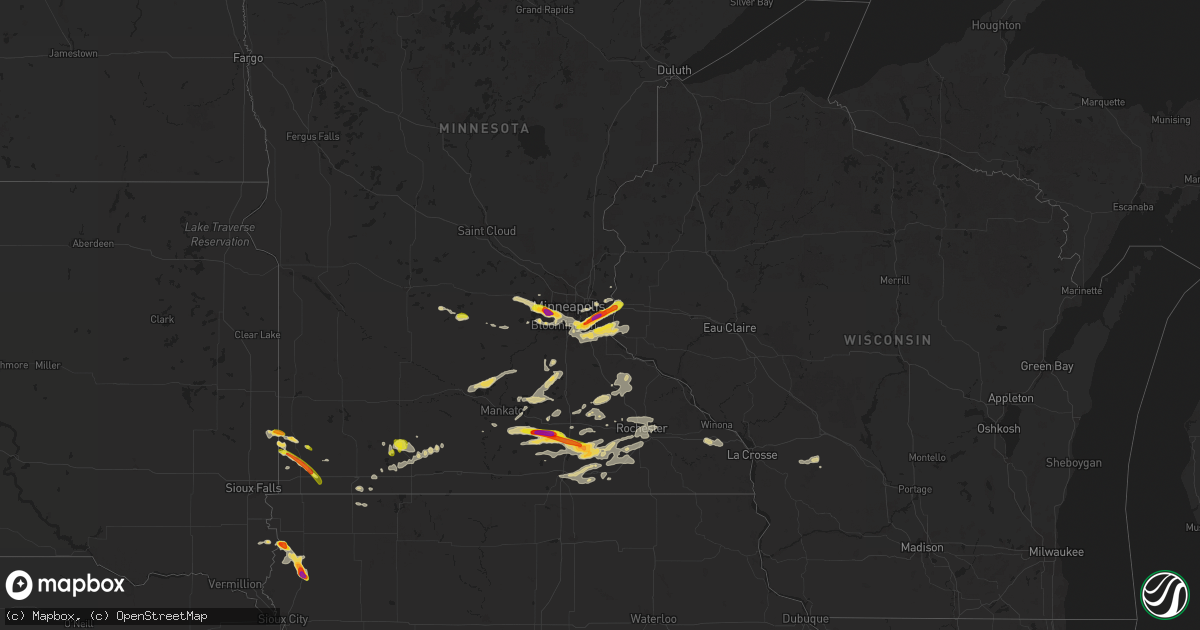
Hail Map on September 21, 2025
Get this storm
September 21 map
$229
one time, instant access
Download today. No call, no setup
Keep the $229
Bought the map and want the full workflow? Apply the entire $229 to a subscription within 7 days. None of it is wasted.
Every map, not just this one
This buys you this map. Subscription and you get every map we run, in the markets you choose from a few cities to whole states to nationwide. Plus real-time alerts the moment a storm fires.
Contact data
Name, contact info, occupancy, even credit band for addresses in the footprint. You go from where it hit to who to call.
Become the source they trust
Unlimited branding weather history reports on demand. You already have the documented answer ready for the property owner, and you are the one who showed up with it.
Property data and RoofTrace estimates
Pull up any address you have got, its value and the exact code rules for that jurisdiction, straight from One Click Code. Then RoofTrace estimates the squares, pitch, and roof value, priced the way you price.
States Impacted by Hail Map on September 21, 2025
Storm reports
Texas
| Date | Description |
|---|---|
| 09/21/20256:35 PM CDT | 68 mph gust measured at twu. |
| 09/21/20256:34 PM CDT | Report from mping. |
| 09/21/20256:25 PM CDT | Report from mping: hen egg |
| 09/21/20256:23 PM CDT | Report from mping. |
| 09/21/20256:17 PM CDT | Report from mping: half dollar |
| 09/21/20256:16 PM CDT | Report from mping: golf ball |
| 09/21/20256:16 PM CDT | A local report indicates 1.75 inch wind near Van Alstyne |
| 09/21/20256:13 PM CDT | Report from mping: ping pong ball |
| 09/21/20256:05 PM CDT | Report from mping. |
| 09/21/20256:05 PM CDT | 60 mph gust measured by the denton airport awos. |
| 09/21/20256:02 PM CDT | 64.2 mph gust measured at hwy |
| 09/21/20256:02 PM CDT | 64.2 mph gust measured at hwy 288 and i-35. |
| 09/21/20256:01 PM CDT | Photos received of multiple trees snapped and branches down just east of desdemona. |
| 09/21/20255:57 PM CDT | Report from mping. |
| 09/21/20255:52 PM CDT | Social media photo and video of large tree uprooted... Approximately 2 feet in diameter. |
| 09/21/20255:51 PM CDT | A weather station approximately 3 miles southeast of howe measured a 62 mph wind gust. Large tree branches were also broken. |
| 09/21/20255:51 PM CDT | Large hail 2.25-2.5 inches in size fell for 8-10 minutes about 3 miles southeast of howe. Windows were broken and roof damage was observed. The weather station at this |
| 09/21/20255:50 PM CDT | Power lines down at bennett rd and fm 902 just east-northeast of howe. |
| 09/21/20255:45 PM CDT | Photo received of measured 1.75 inch hail. Time estimated. |
| 09/21/20255:39 PM CDT | Report from mping. |
| 09/21/20255:35 PM CDT | Social media video of a semi trailer blown over onto two other vehicles on i35 near sanger. Exact location unknown. |
| 09/21/20255:35 PM CDT | In addition to hail also reported a blown over chicken coop. |
| 09/21/20255:35 PM CDT | Report from mping: ping pong ball |
| 09/21/20255:33 PM CDT | Broken tree limbs and power poles were reported on belz road north of sanger. |
| 09/21/20255:32 PM CDT | Partial wall collapse at a walmart distribution center. Time estimated. |
| 09/21/20255:32 PM CDT | Multiple overturned campers at the sanger koa on i35 near view road. Time estimated. |
| 09/21/20255:31 PM CDT | A local report indicates 1.00 inch wind near 1 E Sanger |
| 09/21/20255:30 PM CDT | Photo received of measured 2.5 inch hail. Time estimated. |
| 09/21/20255:30 PM CDT | Report from mping. |
| 09/21/20255:23 PM CDT | A local report indicates 1.25 inch wind near 2 SSE Knollwood |
| 09/21/20255:21 PM CDT | Report from mping. |
| 09/21/20255:03 PM CDT | Kgyi. |
| 09/21/20254:35 PM CDT | Scattered downed trees and sheet metal removed from buildings throughout olney. Wooden power poles leaning. |
| 09/21/20255:30 AM CDT | An analysis of tree damage in and around the roanoke area suggests winds up to 60 mph broke many large tree limbs. |
| 09/21/20253:49 AM CDT | A 72 mph wind gust was measured in ponder. Large tree damage was reported southeast of fm 156 and fm 2449... Along with minor roof damage. Large tree limbs were broken. |
| 09/20/20259:59 PM CDT | A local report indicates 61 MPH wind near Evant |
| 09/20/20259:26 PM CDT | Kmnz. |
| 09/20/20257:50 PM CDT | Front entrance of a building collapsed inward with glass blown out of the front windows in mingus. |
| 09/20/20257:50 PM CDT | Front |
| 09/20/20257:33 PM CDT | A mobile home lost its roof and outbuildings were knocked down on cr 347... Located southeast of proctor. |
Minnesota
| Date | Description |
|---|---|
| 09/21/20256:59 PM CDT | A local report indicates 1.25 inch wind near Edgerton |
| 09/21/20256:51 PM CDT | Storm chaser reported increasing hail activity and size at 6:51 pm cdt. They also reported a rotating wall cloud. |
| 09/21/20256:00 PM CDT | A local report indicates 1.25 inch wind near 6 W Lemond |
| 09/21/20255:54 PM CDT | A local report indicates 2.00 inch wind near 6 NNW New Richland |
| 09/21/20255:51 PM CDT | Spotter measured hailstones of penny to quarter size. |
| 09/21/20255:41 PM CDT | A local report indicates 1.50 inch wind near 3 W Pipestone |
| 09/21/20255:33 PM CDT | A local report indicates 1.00 inch wind near 6 W Pipestone |
| 09/21/20255:16 PM CDT | Delayed report... Time estimated from radar. Hail covering the ground... With the largest stone quarter-sized. Also tree branches down. |
| 09/20/202511:05 PM CDT | Trained spotter reported pea sized hail and small branches down near county border. |
| 09/20/202510:57 PM CDT | A few trees snapped. Trunks roughly 6 to 12 inches in diameter. |
| 09/20/202510:57 PM CDT | A few trees snapped. Trunks roughly 6 to 12 inches in diameter. |
| 09/20/20259:47 PM CDT | Hail was quarter size or smaller. Time estimated from radar. |
| 09/20/20259:20 PM CDT | Report from mping: hen egg |
| 09/20/20259:16 PM CDT | Report from mping: ping pong ball |
| 09/20/20259:16 PM CDT | Repo |
| 09/20/20259:16 PM CDT | Report from mping: ping pong ball (1.50 in. |
| 09/20/20259:15 PM CDT | A local report indicates 1.75 inch wind near 1 SSW Minnetonka |
| 09/20/20259:15 PM CDT | (mp |
| 09/20/20259:14 PM CDT | A local report indicates 1.25 inch wind near 1 SSE Minnetonka |
| 09/20/20259:12 PM CDT | A local report indicates 1.00 inch wind near 1 NNW Hopkins |
| 09/20/20259:10 PM CDT | A local report indicates 1.00 inch wind near 2 W Hutchinson |
| 09/20/20259:07 PM CDT | A local report indicates 1.75 inch wind near 1 SE Deephaven |
| 09/20/20259:05 PM CDT | Report and picture sent via x. |
| 09/20/20259:04 PM CDT | Report from mping: quarter |
| 09/20/20258:30 PM CDT | Spotter reported quarter to half dollar sized hail at 8:30 pm cdt. |
| 09/20/20258:21 PM CDT | Report from mping: half dollar |
| 09/20/20258:21 PM CDT | Report from mping: ping pong ball |
| 09/20/20258:21 PM CDT | Report from mping: quarter |
| 09/20/20258:17 PM CDT | Sent via x. |
| 09/20/20258:14 PM CDT | Mping report. |
| 09/20/20258:10 PM CDT | Had about 2 minutes of 0.5 to 1.5 inch hail. |
| 09/20/20258:10 PM CDT | Picture sent via x. |
| 09/20/20258:07 PM CDT | A local report indicates 1.75 inch wind near 1 SSE South St. Paul |
| 09/20/20258:06 PM CDT | A local report indicates 1.00 inch wind near 1 NNE Inver Grove Heigh |
| 09/20/20257:30 PM CDT | Spotter reported heavy rain and quarter sized hail at 7:30 pm cdt. |
| 09/20/20257:10 PM CDT | Delayed report... Time estimated from radar. Golf ball size hail on hwy 30 west of blooming prairie. |
| 09/20/20257:08 PM CDT | Delayed report... Time estimated from radar. Lots of hail... The largest around quarter-sized. |
| 09/20/20257:00 PM CDT | Public report of hail 1 inch at 7:00 pm cdt. |
| 09/20/20257:00 PM CDT | Time estimated based on radar. |
Illinois
| Date | Description |
|---|---|
| 09/21/20255:00 PM CDT | Delayed report. Damage to home siding and a gutter ripped from a garage. Relayed by wcia tv media. |
| 09/21/20253:59 PM CDT | Report of trees down in lakemoor near il 120. Time estimated by radar. |
| 09/21/20253:57 PM CDT | Social media report of two trees down near hoff road entrance to midewin national tallgrass prarie. The person who reported the damage noted their personal weather stat |
| 09/21/20253:52 PM CDT | Tree limb roughly 6 inches in diameter downed partially blocking eastbound river road near i-55. Time es |
| 09/21/20253:52 PM CDT | Tree limb roughly 6 inches in diameter downed partially blocking eastbound river road near i-55. Time estimated by radar. |
| 09/21/20253:51 PM CDT | Report of power line wires down in roadway. Time estimated by radar. |
| 09/21/20253:48 PM CDT | Photo shared on social media of a tree limb roughly 6 to 8 inches in diameter and about 15 to 20 feet long downed in homewood. Time estimated by radar. |
| 09/21/20253:38 PM CDT | Report of power line wires down in roadway. Time estimated by radar. |
| 09/21/20253:38 PM CDT | Corrects the timing of previous tstm wnd dmg report from 1 nne bull valley. Report of power line wires down in roadway. Time estimated by radar. |
| 09/21/20253:38 PM CDT | Photo shared on social media showing 1 to 1.25 inch hail. Time estimated by radar. |
| 09/20/20257:37 PM CDT | Power outages reported in springfield at illes park... Harvard park... Skyline heights. |
| 09/20/20257:04 PM CDT | Em reports one tree blown onto a house and 4 trees down on roadways in jacksonville. |
| 09/20/20257:04 PM CDT | Em reports one tree blown onto a house and 4 trees down on roadways in jacksonv |
Michigan
| Date | Description |
|---|---|
| 09/21/20256:07 PM CDT | Report from mping: quarter |
Oklahoma
| Date | Description |
|---|---|
| 09/21/20253:48 PM CDT | Report from mping: quarter |
| 09/21/20253:46 PM CDT | Strong thunderstorm wind snapped large tree limbs. |
| 09/21/20252:40 PM CDT | The oklahoma mesonet station near haskell measured 65 mph thunderstorm wind gusts. |
| 09/20/20258:40 PM CDT | A local report indicates 67 MPH wind near 1 NW Lane |
| 09/20/20257:28 PM CDT | Roof damage to home. At least one tree down in vicinity. Estimated wind speeds 60-70mph. |
Iowa
| Date | Description |
|---|---|
| 09/20/20259:15 PM CDT | Report relayed by broadcast media. |
| 09/20/20257:55 PM CDT | Spotter reported quarters at 7:55 pm cdt. |
| 09/20/20257:35 PM CDT | Estimated ping pong ball to golf ball size hail. Time estimated from radar. |
Florida
| Date | Description |
|---|---|
| 09/21/20252:25 PM CDT | Estimated from video on social media from the windswept dunes neighborhood. |
Ohio
| Date | Description |
|---|---|
| 09/21/20253:49 PM CDT | Tree down into wires on cleveland road southwest. Time estimated from radar. |
| 09/21/20252:00 PM CDT | Trees down near sr 380 and buck run road. Time estimated from radar. |
| 09/21/20251:37 PM CDT | Several trees down across harlan township in southeast warren county. Time estimated from radar data. |
| 09/21/20251:27 PM CDT | Trees down on power lines- time radar estimate. |
| 09/21/20251:22 PM CDT | Large tree limbs on power lines- radar estimated time. |
| 09/21/20251:16 PM CDT | Large 2 foot diameter branch fell on house... Causing damage to roof. Time estimated from radar data. |
| 09/21/20251:16 PM CDT | 3 foot diameter tree down. |
| 09/21/20251:16 PM CDT | Several trees and large limbs down along bailey drive. Time estimated from radar data. |
Louisiana
| Date | Description |
|---|---|
| 09/21/20256:50 PM CDT | Nws employee reported half dollar sized hail. |
| 09/21/20256:45 PM CDT | Spotter measured ping pong ball sized hail at the target at airline and i-220. |
| 09/21/20256:45 PM CDT | Nws employee measured ping pong ball sized hail. |
| 09/21/20256:31 PM CDT | An nws storm survey confirmed several areas of trees with limbs broken by wind gusts estimated up to 70 mph in the shreveport downtown riverfront vicinity. |
| 09/21/20256:31 PM CDT | An nws storm survey confirmed several areas of trees with limbs broken by wind gusts estimated up to 70 mph in the shreveport downtown riverfront vicinity. |
Arkansas
| Date | Description |
|---|---|
| 09/20/20258:59 PM CDT | A local report indicates 1.00 inch wind near Van Buren |
Utah
| Date | Description |
|---|---|
| 09/20/20258:10 PM CDT | Mesonet station pc358 hansel valley. |
| 09/20/20257:40 PM CDT | Mesonet station utedl i-80 at mp 71 east delle. |
Tennessee
| Date | Description |
|---|---|
| 09/21/20255:17 PM CDT | Tspotter report of a large tree down on greenland drive. Time is radar estimated. |
Wisconsin
| Date | Description |
|---|---|
| 09/20/20258:37 PM CDT | A local report indicates 1.00 inch wind near 1 N Hudson |
Cities Impacted by Hail Map on September 21, 2025
- Jamestown, TN
- Oneida, TN
- Pall Mall, TN
- Quincy, MO
- Weaubleau, MO
- Milford, OH
- Cincinnati, OH
- Loveland, OH
- Goshen, OH
- Wheatland, MO
- Pleasant Plain, OH
- Blanchester, OH
- Morrow, OH
- Williamsburg, KY
- Spencer, TN
- Ponce De Leon, FL
- Calhoun, KY
- Only, TN
- Morris, OK
- Boynton, OK
- Freeport, FL
- Duncan, OK
- Haskell, OK
- Defuniak Springs, FL
- Council Hill, OK
- Oktaha, OK
- Muskogee, OK
- Taft, OK
- Porter, OK
- Lewisport, KY
- Philpot, KY
- Westport, TN
- Holladay, TN
- Hawesville, KY
- Buena Vista, TN
- Wildersville, TN
- Yuma, TN
- Ardmore, OK
- Le Roy, IL
- Monee, IL
- Checotah, OK
- Lone Grove, OK
- Tell City, IN
- Cannelton, IN
- Morris, IL
- Warner, OK
- Seymour, TX
- Slater, MO
- Alligator, MS
- Wendell, ID
- Louisa, KY
- Miami, MO
- Marshall, MO
- Holliday, TX
- Derby, IN
- Mchenry, IL
- Woodstock, IL
- Frankfort, IL
- Coal City, IL
- Channahon, IL
- Wilmington, IL
- Lenoir City, TN
- Clarksdale, MS
- Leopold, IN
- Lexington, TN
- Porum, OK
- Gilliam, MO
- Crystal Lake, IL
- Henderson, TN
- Olney, TX
- Harriman, TN
- Madill, OK
- Webbers Falls, OK
- Parsons, TN
- Island Lake, IL
- Elwood, IL
- Round Lake, IL
- Wauconda, IL
- Ingleside, IL
- Grayslake, IL
- Fox Lake, IL
- Flat Rock, AL
- Mazon, IL
- Gardner, IL
- Matteson, IL
- Manhattan, IL
- Henrietta, TX
- Braceville, IL
- Park Valley, UT
- Mapleton, MN
- Good Thunder, MN
- Bowie, TX
- Nocona, TX
- Gainesville, TX
- Stigler, OK
- Bellevue, TX
- Garden City, MN
- Sulphur, OK
- Keota, OK
- Grouse Creek, UT
- Pemberton, MN
- Valley View, TX
- Lake Crystal, MN
- Era, TX
- Denison, TX
- Pottsboro, TX
- Sherman, TX
- Snowville, UT
- Malta, ID
- Eufaula, OK
- Saint Jo, TX
- Forestburg, TX
- Newcastle, TX
- Graham, TX
- Loving, TX
- Janesville, MN
- Sanger, TX
- Ringgold, TX
- Waseca, MN
- Murfreesboro, TN
- Flandreau, SD
- Mankato, MN
- Centerville, MO
- Quinton, OK
- Kinta, OK
- Vian, OK
- Sallisaw, OK
- Howe, TX
- Aubrey, TX
- Denton, TX
- Van Alstyne, TX
- Whitewright, TX
- Tom Bean, TX
- Whitefield, OK
- Waldorf, MN
- New Richland, MN
- Pipestone, MN
- Black, MO
- Anna, TX
- Ellendale, MN
- Owatonna, MN
- Belleview, MO
- New London, MO
- Niles, MI
- Spiro, OK
- Krum, TX
- Muldrow, OK
- Gans, OK
- Versailles, IL
- Kinderhook, IL
- Wilson, OK
- Ringling, OK
- Dowagiac, MI
- Barry, IL
- Dublin, TX
- Desdemona, TX
- Melissa, TX
- Edgerton, MN
- Waynesboro, MS
- Trent, SD
- Jasper, MN
- Perrin, TX
- Shreveport, LA
- De Leon, TX
- Breckenridge, TX
- South Bend, TX
- Mckinney, TX
- Blue Ridge, TX
- Blooming Prairie, MN
- Decatur, MI
- Alcester, SD
- Bossier City, LA
- Argyle, TX
- Whitt, TX
- Waterville, MN
- Hudson, SD
- Braidwood, IL
- Montgomery, MN
- Madison Lake, MN
- Cleveland, MN
- Elysian, MN
- Lawton, MI
- Paw Paw, MI
- Graford, TX
- Strawn, TX
- Mineral Wells, TX
- Mattawan, MI
- Barksdale Afb, LA
- Franklin, IL
- Alexander, IL
- Waverly, IL
- Webster, MN
- Elko New Market, MN
- Lonsdale, MN
- Caddo, TX
- New Prague, MN
- Benton, LA
- Lewisville, TX
- Moore, ID
- Mannsville, OK
- Hardwick, MN
- Loami, IL
- Richland, MI
- Luverne, MN
- Kenneth, MN
- Worthington, MN
- Rock Valley, IA
- Hawarden, IA
- Saint Paul Park, MN
- Hastings, MN
- Cottage Grove, MN
- Rochester, IL
- Morristown, MN
- Saint Paul, MN
- Inver Grove Heights, MN
- South Saint Paul, MN
- Okabena, MN
- Brewster, MN
- Mingus, TX
- Eureka, NV
- Rosemount, MN
- River Falls, WI
- Gordon, TX
- Sioux Center, IA
- Newport, MN
- Lakefield, MN
- Round Lake, MN
- Montrose, MN
- Delano, MN
- Blackfoot, ID
- Ocheyedan, IA
- Gustine, TX
- Ranger, TX
- Ireton, IA
- Burnsville, MN
- Magnolia, MN
- Adrian, MN
- Afton, MN
- Lake Elmo, MN
- Cosmos, MN
- Windom, MN
- Maurice, IA
- Carlton, TX
- Roland, OK
- Lakeland, MN
- Stillwater, MN
- Hudson, WI
- Maple Plain, MN
- Jackson, MN
- Bingham Lake, MN
- Stephenville, TX
- Litchfield, MN
- Hamilton, TX
- Mound, MN
- Long Lake, MN
- Wayzata, MN
- Hutchinson, MN
- Downs, IL
- Le Mars, IA
- Trimont, MN
- Odin, MN
- Fort Smith, AR
- Mountain Lake, MN
- Spring Park, MN
- Arkoma, OK
- Pocola, OK
- Excelsior, MN
- Minnetonka, MN
- Hopkins, MN
- New Richmond, WI
- Saint James, MN
- Ormsby, MN
- University Park, IL
- Crete, IL
- Park Forest, IL
- Chicago Heights, IL
- Steger, IL
- Thornton, IL
- Homewood, IL
- Hazel Crest, IL
- Glenwood, IL
- Butterfield, MN
- Minneapolis, MN
- Richton Park, IL
- Barling, AR
- Heron Lake, MN
- Eden Prairie, MN
- Evant, TX
- Van Buren, AR
- Chanhassen, MN
- Bunch, OK
- Cookson, OK
- Hamel, MN
- Glencoe, MN
- Ellsinore, MO
- Greenville, MO
- Young America, MN
- Plato, MN
- Alpha, MN
- Norwood Young America, MN
- Williamsville, MO
- Mill Spring, MO
- Poplar Bluff, MO
- Silver Lake, MN
- Lester Prairie, MN
- New Germany, MN
- Watertown, MN
- Saint Bonifacius, MN
- Mayer, MN
- Courtland, MN
- New Ulm, MN
- Marquand, MO
- Saint Peter, MN
- Victoria, MN
- Waconia, MN
- Nicollet, MN
- Farmington, MN
- Chaska, MN
- Le Sueur, MN
- Hartland, MN
- Prescott, WI
- Eagle Lake, MN
- Kilkenny, MN
- Claremont, MN
- Kenyon, MN
- Faribault, MN
- Lismore, MN
- Northfield, MN
- Bayport, MN
- West Concord, MN
- Wanamingo, MN
- Goodhue, MN
- Hayfield, MN
- Zumbrota, MN
- Mazeppa, MN
- Medford, MN
- Cecil, AR
- Ozark, AR
- Dodge Center, MN
- Ratcliff, AR
- Kasson, MN
- Mantorville, MN
- Sebree, KY
- Paris, AR
- Byron, MN
- Rochester, MN
- Oronoco, MN
- Justin, TX
- Ponder, TX
- Stewartville, MN
- Eyota, MN
- Sargeant, MN
- Waltham, MN
- Minnesota Lake, MN
- Foster, OK
- Geneva, MN
- Dexter, MN
- Brownsdale, MN
- Grand Meadow, MN
- Rushford, MN
- Albert Lea, MN
- Lewiston, MN
- Austin, MN
- Houston, MN
- Winona, MN
- Edinburg, IL
- Fort Worth, TX
- Roanoke, TX
- New Berlin, IL
- Mechanicsburg, IL
- Racine, MN
- Glenville, MN
- Hayward, MN
- Rose Creek, MN
- Sparta, WI
- Norwalk, WI
- Kendall, WI
- Hillsboro, WI
- Ontario, WI
- Wilton, WI
- Cashton, WI
- Hollandale, MN
- Lansing, MN