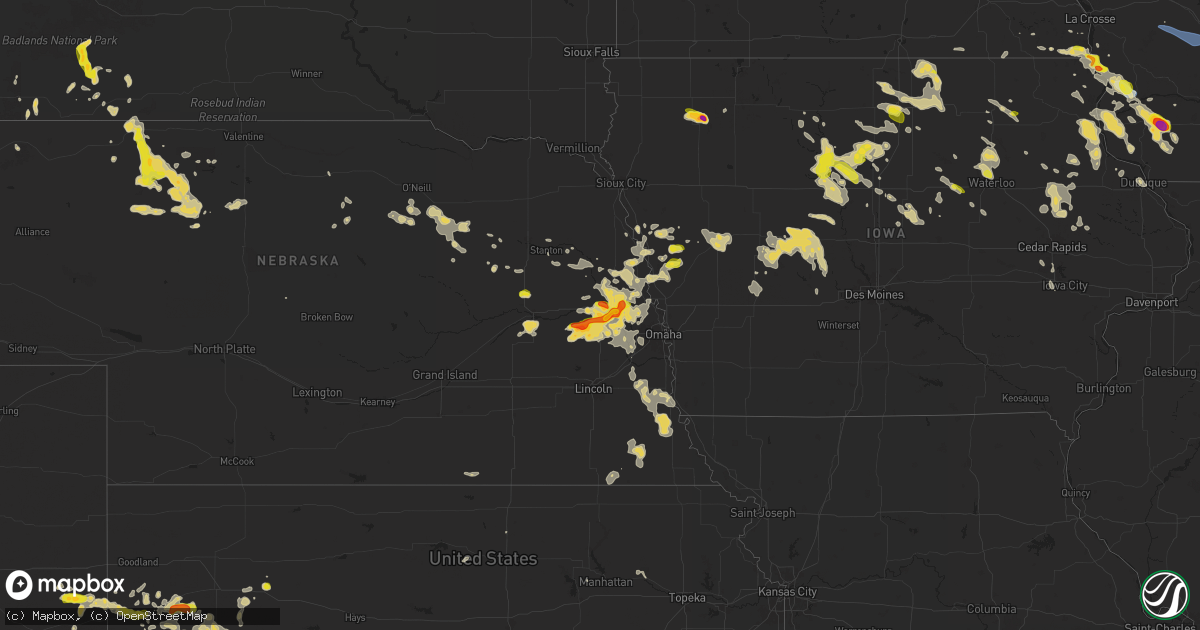
Hail Map on September 22, 2025
Get this storm
September 22 map
$229
one time, instant access
Download today. No call, no setup
Keep the $229
Bought the map and want the full workflow? Apply the entire $229 to a subscription within 7 days. None of it is wasted.
Every map, not just this one
This buys you this map. Subscription and you get every map we run, in the markets you choose from a few cities to whole states to nationwide. Plus real-time alerts the moment a storm fires.
Contact data
Name, contact info, occupancy, even credit band for addresses in the footprint. You go from where it hit to who to call.
Become the source they trust
Unlimited branding weather history reports on demand. You already have the documented answer ready for the property owner, and you are the one who showed up with it.
Property data and RoofTrace estimates
Pull up any address you have got, its value and the exact code rules for that jurisdiction, straight from One Click Code. Then RoofTrace estimates the squares, pitch, and roof value, priced the way you price.
States Impacted by Hail Map on September 22, 2025
Storm reports
Mississippi
| Date | Description |
|---|---|
| 09/22/20254:49 PM CDT | Tree down near the intersection of willis and new africa road. |
| 09/22/20253:11 PM CDT | Tree and power lines down. Tree on old hwy 7 south... Where a car struck the downed tree. Power lines down on hwy 7 north and hwy 311. Time estimated via radar. |
Ohio
| Date | Description |
|---|---|
| 09/22/20256:53 PM CDT | Rock run rd & us rt 35 closed due to a down tree. |
| 09/22/20256:42 PM CDT | Tree down blocking one lane of traffic. |
| 09/22/20256:42 PM CDT | Tree down blocking one lane of traffic. (r |
| 09/22/20256:42 PM CDT | Tree down blocking one lane of tra |
| 09/22/20256:21 PM CDT | Tree down into power lines blocking the road. |
| 09/22/20256:13 PM CDT | Several trees down. |
| 09/22/20256:12 PM CDT | Tree down reported in jefferson street. |
| 09/22/20255:13 PM CDT | Trees down on 52 near buena vista. Time estimated from radar. |
| 09/22/20254:28 PM CDT | Multiple trees down on us52 between higginsport and ripley. Time estimated from radar. |
| 09/22/202512:50 PM CDT | Tree and utility wires down. |
| 09/22/202512:45 PM CDT | Tree down. |
Nebraska
| Date | Description |
|---|---|
| 09/21/20259:00 PM CDT | Social media report with photos of ping pong ball sized hail on the east side of fremont. Time estimated based on radar. |
| 09/21/20258:48 PM CDT | A local report indicates 1.00 inch wind near 2 NNW Fremont |
| 09/21/20258:47 PM CDT | Golf ball size hail reported covering the ground. |
| 09/21/20258:47 PM CDT | Delayed report relayed via social media of several measured 2 inch in diameter hailstones. Time estimated with radar. |
| 09/21/20258:47 PM CDT | Report from mping: ping pong ball |
| 09/21/20258:47 PM CDT | Report from mping: quarter |
| 09/21/20258:45 PM CDT | Report from mping: half dollar |
| 09/21/20258:37 PM CDT | Report from mping: ping pong ball |
| 09/21/20258:36 PM CDT | Ping pong ball size hail reported near prague. |
| 09/21/20258:30 PM CDT | Quarter size hail in cedar bluffs. Hail lasted about 7 minutes. |
| 09/21/20258:28 PM CDT | Trained spotter estimated 60 mph thunderstorms wind gusts with pea sized hail. |
| 09/21/20258:26 PM CDT | A local report indicates 1.75 inch wind near 2 W Prague |
| 09/21/20258:10 PM CDT | Trained spotter reports hail ranging from pea to 1.25 inches in merriman. |
Michigan
| Date | Description |
|---|---|
| 09/22/20254:50 PM CDT | Tornado tran |
| 09/22/20254:50 PM CDT | Tornado transitioned into a waterspout over torch lake with multiple images and videos of the tornadic waterspout over torch lake. Time and exact location of touchdown |
| 09/22/20254:50 PM CDT | Corrects previous tornado report from kewadin. Tornado northeast of kewadin transitioned into a waterspout over torch lake with multiple images and videos of the tornad |
| 09/22/20253:50 PM CDT | Video relayed by media of brief... Weak tornado crossing the road. Location estimated via radar. |
Texas
| Date | Description |
|---|---|
| 09/22/20256:00 PM CDT | A local report indicates 1.75 inch wind near Mabelle |
| 09/21/202510:06 PM CDT | Mesonet station 106 happy 1e. |
| 09/21/20259:35 PM CDT | Awos station khrx hereford |
| 09/21/20259:28 PM CDT | A local report indicates 59 MPH wind near 2 WNW Hereford |
New Mexico
| Date | Description |
|---|---|
| 09/22/20255:50 PM CDT | Mesonet station wsm30 phillips hill |
| 09/22/20254:25 PM CDT | Trained spotter in magdalena reported an estimated wind gust of about 60 mph. No damage reported. |
| 09/21/20258:36 PM CDT | Mesonet station 107 endee 2 sw. |
| 09/21/20258:14 PM CDT | Mesonet station mrrn5 tolar 13 se |
| 09/21/20258:05 PM CDT | Asos station krow roswell air center. |
Oklahoma
| Date | Description |
|---|---|
| 09/22/202512:35 AM CDT | A local report indicates 62 MPH wind near 3 SSW Freedom |
| 09/22/202512:30 AM CDT | A local report indicates 59 MPH wind near 3 SSW Freedom |
| 09/21/202511:32 PM CDT | Asos station kgag gage. |
Iowa
| Date | Description |
|---|---|
| 09/22/20256:40 PM CDT | Ts reported 2 inch hail between 6:40 and 6:50 pm cdt. Heavy rain and nickles to dimes ongoing at time of the call at 7:09 pm. |
| 09/22/20256:08 PM CDT | Photo relayed by media via nws chat. |
| 09/22/20255:33 PM CDT | Time estimated. |
| 09/22/20254:35 PM CDT | Photo relayed by media via nws chat. |
| 09/21/202510:12 PM CDT | Report from mping: quarter |
| 09/21/20259:20 PM CDT | Several large tree branches greater than 3 inches in diameter down around the city. |
| 09/21/20258:30 PM CDT | Measured by a personal weat |
| 09/21/20258:30 PM CDT | Measured by a personal weather station. |
| 09/21/20258:25 PM CDT | A local report indicates 1.00 inch wind near 2 S Dike |
| 09/21/20258:20 PM CDT | Received via social media. Occurred at prestage foods of iowa. |
| 09/21/20258:03 PM CDT | Spotter reports quarter sized hail fell just north of the clarion city limits. Time estimated. |
| 09/21/20258:02 PM CDT | A local report indicates 1.00 inch wind near 4 SE Dakota City |
| 09/21/20257:40 PM CDT | Ts reported quarter sized hail at approximately 7:40 pm cdt. He also reported that at the time of the call... 7:45 pm... That the hail had ended and it was just really |
| 09/21/20257:22 PM CDT | Social media image of quarter sized hail. Relayed by kwwl. Time estimated from radar. |
| 09/21/20257:20 PM CDT | Social media post with picture of a hailstone the size of a quarter. Time confirmed with radar. |
| 09/21/20257:00 PM CDT | Em reported 2 inch hail on the north side of southerland. Pictures included confirm size. Time was estimated by radar. |
Colorado
| Date | Description |
|---|---|
| 09/22/20255:56 PM CDT | Mesonet station co098 139s034 douglas pass. |
Wisconsin
| Date | Description |
|---|---|
| 09/22/20256:29 PM CDT | Report relayed via nws chat. |
| 09/22/20256:13 PM CDT | Estimated was hit by up to 2 inch hail while driving. |
| 09/22/20256:13 PM CDT | Estimated |
| 09/22/20256:08 PM CDT | A local report indicates 2.00 inch wind near 2 S Montfort |
| 09/22/20252:52 PM CDT | A local report indicates 1.00 inch wind near De Soto |
| 09/22/20257:11 AM CDT | Several trees and power lines down at the intersection of cth ww and oak lane. |
| 09/21/20258:41 PM CDT | Several trees and wires down in the delafield area. Wind gusts estimated at 55-60 mph. |
| 09/21/20258:00 PM CDT | Law enforcement reports several trees down near ixonia wi. |
| 09/21/20257:02 PM CDT | Public report of 1 inch diameter hail near reeseville. Time confirmed via radar. |
Kansas
| Date | Description |
|---|---|
| 09/22/20255:14 PM CDT | Ambient weather site section 17 reported the wind gust. |
| 09/22/20255:22 AM CDT | Delayed report for one large tree blown down over the highway and damage to a road sign. |
| 09/22/20255:22 AM CDT | Delayed report fo |
| 09/22/20251:57 AM CDT | Wind gust measured from pws. |
| 09/22/20251:08 AM CDT | The awos reported a 61 mph wind gust. |
| 09/22/20251:08 AM CDT | The awos reported a 61 mph wind gust. |
| 09/21/202510:00 PM CDT | Facebook photo. |
| 09/21/20259:36 PM CDT | Weather link site delta dos. |
| 09/21/20257:38 PM CDT | Delayed report of quarter size hail 5 inches deep. Time estimated by radar. |
| 09/21/20257:22 PM CDT | A local report indicates 60 MPH wind near 3 E Grinnell |
Alabama
| Date | Description |
|---|---|
| 09/22/20254:00 PM CDT | Multiple trees down along cain rd. |
Kentucky
| Date | Description |
|---|---|
| 09/22/20256:55 PM CDT | Tree on school property fell onto roadway and on to both of rps vehicles. |
| 09/22/20256:52 PM CDT | Tree fell into a residence on clay street. Powerlines involved. |
| 09/22/20256:13 PM CDT | Tree branch and power lines down. |
| 09/22/20256:10 PM CDT | Tree down on state route 5. |
| 09/22/20255:57 PM CDT | Tree reported down along south state highway one. Time and location are estimated by radar. |
| 09/22/20255:52 PM CDT | Tree reported down on road. |
| 09/22/20255:52 PM CDT | Corrects previous tstm wnd dmg report from 1 n grayson. Tree reported down on road. Time is estimated by radar. |
| 09/22/20255:47 PM CDT | Several tree limbs and tree debris reported to have been blown down onto ky route 7 near the morgan county line. The event time is radar estimated. |
| 09/22/20255:40 PM CDT | Tree damage resulting in 571 customers without power. |
| 09/22/20255:39 PM CDT | Corrects previous tstm wnd dmg report from 1 e south shore for time of occurrence. Tree on school property fell onto roadway and on to both of rps vehicles. Time is est |
| 09/22/20255:35 PM CDT | A tree was reported to have been blown down onto ky 7 about 0.5 miles from the sandy hook city limits. The event time is radar estimated. |
| 09/22/20255:33 PM CDT | A tree was reported to have been blown down onto ky 1812 very close to the breathitt county line. The event time is radar estimated. |
| 09/22/20255:31 PM CDT | A tree was blown onto ky 772 about one quarter of a mile from us 460. |
| 09/22/20255:27 PM CDT | Delayed report. A nws employee came across downed trees blocking shoal branch road on their way into work this morning. Time estimated via radar. |
| 09/22/20255:24 PM CDT | Tree down with wires. Blocking driveways near kentucky drive. Time estimated from radar. |
| 09/22/20255:19 PM CDT | A tree was reported to have been blown down onto little bloody creek road near the flat and mary communities. The even time is radar estimated. |
| 09/22/20255:18 PM CDT | Delayed report from the highway department in fleming county. Downed trees were blocking the intersection of big run road and suit lane. Time estimated via radar. |
| 09/22/20255:16 PM CDT | Tree down blocking east bound lane of kentucky 8. Time estimated from radar. |
| 09/22/20255:08 PM CDT | A tree was blown down onto ky 52 blocking the roadway approximately 1 mile east from the ky 11 and ky 52 intersection. The event time is radar estimated. |
| 09/22/20255:02 PM CDT | A tree was reported to have been blown down onto adams branch road. |
| 09/22/20254:50 PM CDT | Bath county em reported downed trees on mudlick road and slate lick road. Time estimated via radar. |
| 09/22/20254:49 PM CDT | Fleming county dispatch received multiple calls of tree damage blocking ky-32/morehead road around 6pm. Exact time estimated via radar. |
| 09/22/20254:47 PM CDT | A utility line was blown down at 6540 e hwy 36. The event time is radar estimated. |
| 09/22/20254:37 PM CDT | A tree was reported down near 100 pecks creek road near the intersection of pecks creek road and ky 11/15. The even time is radar estimated. |
| 09/22/20254:36 PM CDT | A tree was reported down onto ky 713 spencer pike at fortune cemetery lane. |
| 09/22/20254:30 PM CDT | A tree was reported down near 300 shady acre lane. The event time is estimated. |
| 09/22/20254:30 PM CDT | Photos on social media of a large tree downed in the front yard of a house near the intersection of levee road and tonkin road south of mount sterling. Time provided by |
| 09/22/20254:19 PM CDT | A tree was blown down onto ky 1326 withing the city limits of mount vernon. The event time is radar estimated. |
| 09/22/20254:07 PM CDT | Social media images showing damage to many trees... Outbuildings... And minor damage to homes along west miami street south of cooper lane. Possible tornado. |
| 09/22/20254:05 PM CDT | At ky-70 and estill hackney road a tree was reported to be down blocking all lanes of the roadway. The event time is radar estimated. |
| 09/22/20254:00 PM CDT | A tree and powerlines down blocking the right lane of ky-39 at petrey road. The event time is radar estimated. |
| 09/22/20253:46 PM CDT | Dispatch reported big tree down on shake rag rd. Time estimated from radar. |
| 09/22/20253:30 PM CDT | Dispatch reported tree blocking road near old pollys shoe store. Also a tree down on upper brush creek rd and another at intersection of angel ridge and ky 501. |
| 09/22/20253:11 PM CDT | Large limb fell on a school bus on raikes hill road in eastern taylor county. No injuries were reported. |
| 09/22/20253:11 PM CDT | Large l |
| 09/22/20253:08 PM CDT | Tree down across reeves rd. |
| 09/22/20253:05 PM CDT | Trees down at bull run and hutchinson rd... Bowen and greenburg... 200 block of chickadee ln... And knifley rd. |
| 09/22/20252:30 PM CDT | Two trees reported down on feather creek road in taylor county. |
| 09/22/20252:30 PM CDT | One tree reported across jarboe road in taylor county. |
Cities Impacted by Hail Map on September 22, 2025
- Ontario, WI
- Kendall, WI
- Elroy, WI
- La Valle, WI
- Hillsboro, WI
- Wonewoc, WI
- Mauston, WI
- Lyndon Station, WI
- Reedsburg, WI
- Preston, MN
- Harmony, MN
- Lime Springs, IA
- Dowagiac, MI
- Kewaskum, WI
- Mabel, MN
- Canton, MN
- Jackson, WI
- West Bend, WI
- Random Lake, WI
- Fredonia, WI
- Adams, MN
- Taopi, MN
- Spring Grove, MN
- Dorchester, IA
- Caledonia, MN
- Eitzen, MN
- Lanesboro, MN
- Versailles, KY
- Lawrenceburg, KY
- Saint Johns, AZ
- Houston, MN
- Brownsville, MN
- Quemado, NM
- New Albin, IA
- De Soto, WI
- Pie Town, NM
- Genoa, WI
- Greensburg, KY
- Datil, NM
- Sparkman, AR
- Ferryville, WI
- Edmonton, KY
- Glens Fork, KY
- Columbia, KY
- Lansing, IA
- Park, KS
- Hoxie, KS
- Quinter, KS
- Grainfield, KS
- Mount Juliet, TN
- Northwood, IA
- Naples, FL
- Lebanon, TN
- Gallatin, TN
- Immokalee, FL
- Saint Ansgar, IA
- Castalian Springs, TN
- Carpenter, IA
- Gays Mills, WI
- Brooksville, KY
- Magdalena, NM
- Foster, KY
- Eastman, WI
- Soldiers Grove, WI
- Mount Vernon, KY
- Crab Orchard, KY
- Berea, KY
- Brodhead, KY
- Steuben, WI
- Boscobel, WI
- Forest City, IA
- Joice, IA
- Fertile, IA
- Augusta, KY
- Clarendon, AR
- Kensett, IA
- Clarksdale, MS
- Holly Grove, AR
- Osage, IA
- Hanlontown, IA
- Grafton, IA
- McKee, KY
- Vanceburg, KY
- Tollesboro, KY
- Vincent, KY
- Booneville, KY
- Beattyville, KY
- Vale, SD
- Wauzeka, WI
- Cheyenne Wells, CO
- Marvell, AR
- Green Valley, AZ
- Amado, AZ
- Garner, IA
- Clear Lake, IA
- Sturgis, SD
- New Hampton, IA
- Ventura, IA
- Mason City, IA
- Poplar Grove, AR
- Lascassas, TN
- Milton, TN
- Murfreesboro, TN
- Lexa, AR
- Plymouth, IA
- Nora Springs, IA
- Cheyenne, WY
- Morehead, KY
- Newell, SD
- Vail, AZ
- Moore Haven, FL
- Rudd, IA
- Rock Falls, IA
- Winona, KS
- Kyle, SD
- Arcadia, FL
- Waucoma, IA
- Lawler, IA
- Saint David, AZ
- Sonoita, AZ
- Rockford, IA
- Fennimore, WI
- Wallace, KS
- Grinnell, KS
- Blue River, WI
- Algona, IA
- Arapahoe, CO
- Floyd, IA
- Charles City, IA
- Truth Or Consequences, NM
- Carrizozo, NM
- Tularosa, NM
- Seymour, TX
- Waukon, IA
- Montfort, WI
- Livingston, WI
- Stitzer, WI
- Rockwell, IA
- Muscoda, WI
- Cobb, WI
- Highland, WI
- Swaledale, IA
- Avoca, WI
- Gove, KS
- Harpers Ferry, IA
- Pine Ridge, SD
- Mount Hope, WI
- Sutherland, IA
- Primghar, IA
- Platteville, WI
- Lancaster, WI
- Waterville, IA
- Monona, IA
- Woodman, WI
- Thornton, IA
- Plainfield, IA
- Kanawha, IA
- Hawkeye, IA
- Bode, IA
- McGregor, IA
- Prairie Du Chien, WI
- Porcupine, SD
- Linden, WI
- Mineral Point, WI
- Rewey, WI
- West Bend, IA
- Spencer, IA
- Royal, IA
- Dougherty, IA
- Waverly, IA
- Lu Verne, IA
- Livermore, IA
- Goodell, IA
- Klemme, IA
- Meservey, IA
- Belmond, IA
- Columbus, WI
- Beaver Dam, WI
- Manderson, SD
- Sheffield, IA
- Belmont, WI
- Bagley, WI
- Whittemore, IA
- Farmersburg, IA
- Wanblee, SD
- Denver, IA
- Reeseville, WI
- Ottosen, IA
- Alexander, IA
- Readlyn, IA
- Tripoli, IA
- Janesville, IA
- Bloomington, WI
- Patch Grove, WI
- Marquette, IA
- Stratton, CO
- Martin, SD
- Clarion, IA
- Cedar Falls, IA
- Allen, SD
- Watertown, WI
- Lowell, WI
- Elkader, IA
- Garnavillo, IA
- Saint Olaf, IA
- Juneau, WI
- Paullina, IA
- Hardy, IA
- Waterloo, IA
- Batesland, SD
- Animas, NM
- Brainard, NE
- Bruno, NE
- Dumont, IA
- Humboldt, IA
- Rowan, IA
- Maynard, IA
- Clyman, WI
- Dunkerton, IA
- Aplington, IA
- Thor, IA
- Blanding, UT
- Dows, IA
- Goldfield, IA
- Eagle Grove, IA
- Merriman, NE
- Linwood, NE
- Weston, NE
- Prague, NE
- Guttenberg, IA
- Garber, IA
- Dakota City, IA
- Platte Center, NE
- Oelwein, IA
- Rutland, IA
- Ixonia, WI
- Lebanon, WI
- Potosi, WI
- Cassville, WI
- Monument, KS
- Abie, NE
- Humphrey, NE
- Bethune, CO
- Vincent, IA
- Parkersburg, IA
- Wellsburg, IA
- Holland, IA
- Wounded Knee, SD
- Strawberry Point, IA
- Badger, IA
- Galt, IA
- Oconomowoc, WI
- Malmo, NE
- Colesburg, IA
- Columbus, NE
- Neosho, WI
- Ashippun, WI
- Woolstock, IA
- Morse Bluff, NE
- Cedar Bluffs, NE
- Burlington, CO
- Fort Dodge, IA
- Clare, IA
- Webster City, IA
- Colon, NE
- Oelrichs, SD
- Stanley, IA
- Aurora, IA
- Chadron, NE
- Dike, IA
- Grundy Center, IA
- Edgewood, IA
- Sherrill, IA
- Fremont, NE
- Duncombe, IA
- Blairsburg, IA
- Winthrop, IA
- New Vienna, IA
- Radcliffe, IA
- Holy Cross, IA
- Durango, IA
- Okauchee, WI
- Nashotah, WI
- Clarksville, IA
- Allison, IA
- Lamont, IA
- Williams, IA
- Reinbeck, IA
- Hartland, WI
- Delafield, WI
- Nickerson, NE
- Arlington, NE
- Craig, NE
- Cody, NE
- Oakland, NE
- Masonville, IA
- Traer, IA
- Buckingham, IA
- Alden, IA
- North Bend, NE
- Dubuque, IA
- Kamrar, IA
- Hudson, IA
- Oakley, KS
- Pewaukee, WI
- Otho, IA
- Jewell, IA
- Dundee, IA
- Walker, IA
- Manchester, IA
- Ames, NE
- Shelby, NE
- Hubbard, IA
- McCallsburg, IA
- East Dubuque, IL
- New Providence, IA
- Coggon, IA
- Center Point, IA
- Osceola, NE
- Eldora, IA
- Hugoton, KS
- Moscow, KS
- Ryan, IA
- Lehigh, IA
- Waukesha, WI
- Hooper, NE
- Blair, NE
- Tekamah, NE
- Modale, IA
- Ulysses, KS
- Conrad, IA
- Zearing, IA
- Gowrie, IA
- Paton, IA
- Harcourt, IA
- Saint Anthony, IA
- Clemons, IA
- Dayton, IA
- Central City, IA
- Weskan, KS
- Herman, NE
- Kennard, NE
- Wahoo, NE
- Stratford, IA
- New Berlin, WI
- Springville, IA
- Union, IA
- Bellwood, NE
- Whitten, IA
- Mondamin, IA
- Sharon Springs, KS
- Scott City, KS
- Hooker, OK
- Pisgah, IA
- Brookfield, WI
- Leoti, KS
- Satanta, KS
- Guymon, OK
- Anamosa, IA
- Monticello, IA
- Churdan, IA
- Rising City, NE
- Jefferson, IA
- Boxholm, IA
- Pilot Mound, IA
- Decatur, NE
- Blencoe, IA
- Scranton, IA
- Grand Junction, IA
- Tyrone, OK
- Little Sioux, IA
- Onawa, IA
- Goodland, KS
- Woodbine, IA
- Moorhead, IA
- Dunlap, IA
- Turpin, OK
- Forgan, OK
- Logan, IA
- Liberal, KS
- Missouri Valley, IA
- Magnolia, IA
- Castana, IA
- Soldier, IA
- Vail, IA
- Mead, NE
- Denison, IA
- Whitman, NE
- Fairfax, IA
- Carroll, IA
- Ute, IA
- Swisher, IA
- Amana, IA
- Superior, NE
- Charter Oak, IA
- Schleswig, IA
- Glidden, IA
- Valentine, NE
- Rippey, IA
- Ralston, IA
- Mapleton, IA
- North Liberty, IA
- Coon Rapids, IA
- Jamaica, IA
- Meade, KS
- Nelson, NE
- Bagley, IA
- Whiting, IA
- Hornick, IA
- Dedham, IA
- Yutan, NE
- Manilla, IA
- Perry, IA
- Templeton, IA
- Dawson, IA
- Tiffin, IA
- Oxford, IA
- Iowa City, IA
- Ashland, KS
- Scribner, NE
- Valley, NE
- Macy, NE
- Linden, IA
- Redfield, IA
- Tilden, NE
- Audubon, IA
- Meadow Grove, NE
- West Point, NE
- Janesville, WI
- Wisner, NE
- Healy, KS
- Gretna, NE
- Waterloo, NE
- Elkhorn, NE
- Ashland, NE
- Beemer, NE
- Fargo, OK
- Shattuck, OK
- Arnett, OK
- Gage, OK
- Sharon, OK
- Woodward, OK
- Mooreland, OK
- Fort Supply, OK
- Hamlin, IA
- Exira, IA
- Omaha, NE
- Bennington, NE
- Freedom, OK
- Waynoka, OK
- Thedford, NE
- Murdock, NE
- Stanton, NE
- Dighton, KS
- Avoca, NE
- Elmwood, NE
- Dodge, NE
- Newman Grove, NE
- Burlington, OK
- Weeping Water, NE
- Winslow, NE
- Waldron, KS
- Hazelton, KS
- Amorita, OK
- Medicine Lodge, KS
- Sharon, KS
- Lindsay, NE
- Kiowa, KS
- Alva, OK
- Cherokee, OK
- Dacoma, OK
- Aline, OK
- Carmen, OK
- Isabel, KS
- Madison, NE
- Clarkson, NE
- Anthony, KS
- Howells, NE
- Medford, OK
- Wakita, OK
- Nash, OK
- Jet, OK
- Hardtner, KS
- Manchester, OK
- Harper, KS
- Bluff City, KS
- Attica, KS
- Nashville, KS
- Zenda, KS
- Spivey, KS
- Buffalo, OK
- Argonia, KS
- Caldwell, KS
- Danville, KS
- Freeport, KS
- Nehawka, NE
- Otoe, NE
- Bassett, NE
- Nebraska City, NE
- Hendersonville, TN
- Milan, KS
- Cottontown, TN
- Mayfield, KS
- Goodlettsville, TN
- Washington, NE
- Wellington, KS
- South Haven, KS
- Norwich, KS
- Milton, KS
- Clearwater, KS
- Conway Springs, KS
- Ithaca, NE
- Union, NE
- Jetmore, KS
- Bethpage, TN
- Talmage, NE
- Percival, IA
- Burwell, NE
- Dunbar, NE
- Lorton, NE
- Spearville, KS
- Brock, NE
- Syracuse, NE
- Kremlin, OK
- Hunter, OK
- Julian, NE
- Auburn, NE
- Johnson, NE
- Peru, NE
- Chambers, NE
- Oneill, NE
- Hanston, KS
- Elk Creek, NE
- Tecumseh, NE
- Amelia, NE
- Atkinson, NE
- Ewing, NE
- Inman, NE
- Steinauer, NE
- Belle Plaine, KS
- Clearwater, NE
- Pawnee City, NE
- Burchard, NE
- Liberty, NE
- Wymore, NE
- Beloit, KS
- Belvue, KS
- Saint Marys, KS
- Elgin, NE
- Oxford, KS
- Geuda Springs, KS
- Arkansas City, KS
- Wamego, KS
- Winfield, KS
- Neligh, NE
- Petersburg, NE
- Chanute, KS
- Girard, KS
- Concordia, KS
- Reeds, MO
- Sarcoxie, MO
- La Russell, MO
- Talala, OK
- Viroqua, WI
- Stoddard, WI
- Waterloo, WI