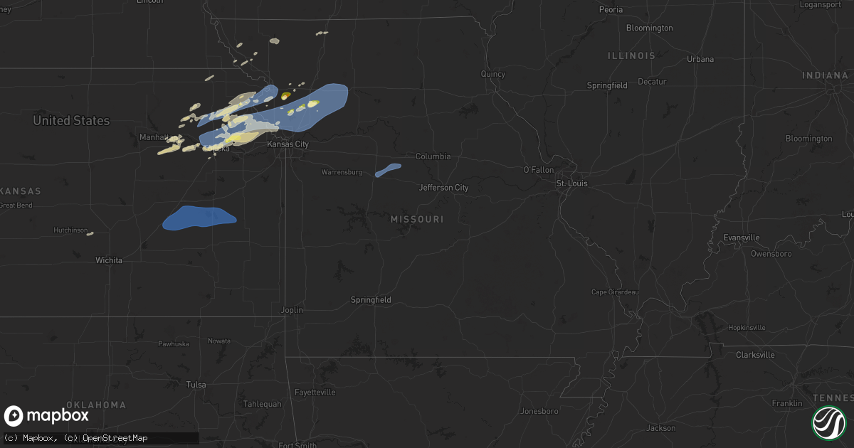
Hail Map in Missouri on October 24, 2024
Get this storm
October 24 map
$229
one time, instant access
Download today. No call, no setup
Keep the $229
Bought the map and want the full workflow? Apply the entire $229 to a subscription within 7 days. None of it is wasted.
Every map, not just this one
This buys you this map. Subscription and you get every map we run, in the markets you choose from a few cities to whole states to nationwide. Plus real-time alerts the moment a storm fires.
Contact data
Name, contact info, occupancy, even credit band for addresses in the footprint. You go from where it hit to who to call.
Become the source they trust
Unlimited branding weather history reports on demand. You already have the documented answer ready for the property owner, and you are the one who showed up with it.
Property data and RoofTrace estimates
Pull up any address you have got, its value and the exact code rules for that jurisdiction, straight from One Click Code. Then RoofTrace estimates the squares, pitch, and roof value, priced the way you price.
Storm reports in Missouri
Missouri
| Date | Description |
|---|---|
| 10/24/20246:21 PM CDT | Delayed social media report and photo of hail up to half dollar size near smithville reservoir. Time estimated from radar. |
| 10/24/20246:20 PM CDT | Spotter reported quarter sized hail between 620-624 pm. |
| 10/24/20246:06 PM CDT | Delayed report. Social media report and photos of hail up to ping pong ball sized northwest of gower. Time and location estimated from radar. |
| 10/23/202411:54 PM CDT | A local report indicates 58 MPH wind near Sedalia Memorial Arpt |
| 10/23/20249:33 PM CDT | Social media report of downed tree limbs south of sugar creek. Time estimated from radar. |
| 10/23/20249:28 PM CDT | Delayed report. Downed wires in the waldo neighborhood. Time estimated from radar and dispatch reports. |
| 10/23/20249:16 PM CDT | Multiple reports of power lines down and power outages... With social media photos and video provided. Time estimated from radar. |
| 10/23/20249:16 PM CDT | Time confirmed from radar. |
| 10/23/20249:14 PM CDT | Route 291 closed between liberty drive and kansas street due to downed power lines. Time estimated from radar. |
| 10/23/20249:14 PM CDT | Delayed report. Social media report of multiple trees and limbs down near a residence southwest of mosby. Time estimated from radar. |
| 10/23/20249:12 PM CDT | Several downed trees and limbs near shoal creek parkway. Time estimated from radar. |
| 10/23/20249:12 PM CDT | Social media report of a downed tree into a shed and a fence at a residence. Time estimated from radar. |
| 10/23/20249:09 PM CDT | Public report of tree limbs down near the pleasant valley area. Time estimated from radar. |
| 10/23/20249:09 PM CDT | Social media report of downed trees and limbs near orchard avenue. Time estimated from radar. |
| 10/23/20249:07 PM CDT | Time confirmed from radar. |
| 10/23/20248:59 PM CDT | Delayed report. Downed wires near hogan drive. Time estimated from radar. |
| 10/23/20248:56 PM CDT | Social media report of downed tree limbs in the parkville area. Time estimated from radar. |
| 10/23/20248:56 PM CDT | Delayed report. Social media photo of multiple trees snapped in the weatherby lake area. Time estimated from radar. |
| 10/23/20248:51 PM CDT | Delayed social media report. Time estimated from radar. |
| 10/23/20248:42 PM CDT | Several reports of power lines down and widespread power outages north of smithville. Time estimated from radar. |
| 10/23/20248:40 PM CDT | Social media report of downed tree limbs on 45 highway spur near farley. Time estimated from radar. |
| 10/23/20248:06 PM CDT | Delayed report. Downed tree limbs and wires near lawson street. Time estimated from radar. |
| 10/23/20248:05 PM CDT | Several reports of trees and wires down in the st. Joseph area. Time estimated from radar. |
| 10/23/20248:04 PM CDT | Social media report of several tree limbs and power lines down on the south side of st. Joseph. Time estimated from radar. |
| 10/23/20248:01 PM CDT | Downed power lines and widespread power outages southwest of st. Joseph. Time estimated from radar. |
| 10/23/20247:04 PM CDT | Report from mping: quarter |
Cities Impacted by Hail Map on October 24, 2024
- Klemme, IA
- Thornton, IA
- Garner, IA
- Alexander, IA
- Clear Lake, IA
- New Ulm, MN
- Ventura, IA
- Meservey, IA
- Mason City, IA
- Rockwell, IA
- Nicollet, MN
- Nora Springs, IA
- Osage, IA
- Rudd, IA
- Hartford, IA
- Swan, IA
- Platte City, MO
- Runnells, IA
- Kansas City, MO
- Gower, MO
- Agency, MO
- Havensville, KS
- Dallas Center, IA
- Trimble, MO
- Onaga, KS
- Wamego, KS
- Plattsburg, MO
- Belvue, KS
- Granger, IA
- Woodward, IA
- Madrid, IA
- Polk City, IA
- Craig, MO
- Alma, KS
- Manhattan, KS
- Lynnville, IA
- Sully, IA
- Burrton, KS
- Goff, KS
- Soldier, KS
- Reasnor, IA
- Pella, IA
- Monroe, IA
- Halstead, KS
- Lathrop, MO
- Searsboro, IA
- Grinnell, IA
- Slater, IA
- Alta Vista, KS
- Montezuma, IA
- Malcom, IA
- Sabetha, KS
- Brooklyn, IA
- Junction City, KS
- Circleville, KS
- Delia, KS
- Emmett, KS
- Holton, KS
- Polo, MO
- Paxico, KS
- Newton, KS
- McFarland, KS
- Turney, MO
- Graham, MO
- Morrill, KS
- Mayetta, KS
- Deep River, IA
- Rhodes, IA
- Melbourne, IA
- Sigourney, IA
- Fairfax, MO
- Horton, KS
- Forest City, MO
- Mound City, MO
- Oregon, MO
- Keota, IA
- Harper, IA
- Williamsburg, IA
- North English, IA
- Millersburg, IA
- Effingham, KS
- Muscotah, KS
- Denison, KS
- Valley Falls, KS
- Parnell, IA
- South English, IA
- Webster, IA
- Maple Hill, KS
- Topeka, KS
- Smithville, MO
- Everest, KS
- Maryville, MO
- Barnard, MO
- Lancaster, KS
- Whiting, KS
- Denton, KS
- Troy, KS
- Maitland, MO
- Cummings, KS
- Atchison, KS
- Brighton, IA
- Washington, IA
- Richland, IA
- Fairfield, IA
- Rossville, KS
- Wellman, IA
- Kalona, IA
- Bendena, KS
- Nortonville, KS
- Conception Junction, MO
- Ravenwood, MO
- Oxford, IA
- Meriden, KS
- Perry, IA
- Saint Joseph, MO
- Wathena, KS
- Ozawkie, KS
- Solon, IA
- De Kalb, MO
- Faucett, MO
- Ainsworth, IA
- Wayland, IA
- Dearborn, MO
- Ridgeway, MO
- Martinsville, MO
- Auburn, KS
- Grantville, KS
- Winchester, KS
- Eagleville, MO
- Riverside, IA
- Easton, MO
- Clarksdale, MO
- Stewartsville, MO
- Hoyt, KS
- Oskaloosa, KS
- Perry, KS
- Lone Tree, IA
- Mount Pleasant, IA
- Crawfordsville, IA
- Columbus Junction, IA
- Winfield, IA
- Conesville, IA
- Nichols, IA
- McLouth, KS
- Easton, KS
- Rushville, MO
- Elwood, KS
- Silver Lake, KS
- Mount Union, IA
- Columbus City, IA
- Morning Sun, IA
- Wapello, IA
- Letts, IA
- New Virginia, IA
- Osceola, IA
- Tonganoxie, KS
- Leavenworth, KS
- Maysville, MO
- Osborn, MO
- Lawrence, KS
- Grandview, IA
- Muscatine, IA
- Bedford, IA
- Victor, IA
- Hartwick, IA
- Fort Leavenworth, KS
- Cameron, MO
- Milo, IA
- Indianola, IA
- Lucas, IA
- New Boston, IL
- Illinois City, IL
- Truro, IA
- Lacona, IA
- Liberty Center, IA
- Edgerton, MO
- Fruitland, IA
- Waldron, MO
- Farley, MO
- Lansing, KS
- Taylor Ridge, IL
- South Amana, IA
- Marengo, IA
- Guernsey, IA
- Aledo, IL
- Reynolds, IL
- Joy, IL
- Knoxville, IA
- Yarmouth, IA
- Mediapolis, IA
- Tiffin, IA
- Homestead, IA
- Belle Plaine, IA
- North Liberty, IA
- Amana, IA
- Oakville, IA
- Keithsburg, IL
- Liberty, MO
- Camden Point, MO
- Weston, MO
- Excelsior Springs, MO
- Holt, MO
- Kingston, MO
- Lawson, MO
- Kearney, MO
- Hamilton, MO
- Kidder, MO
- Orrick, MO
- Cowgill, MO
- Rayville, MO
- Richmond, MO
- Missouri City, MO
- Mooresville, MO
- Breckenridge, MO
- Ludlow, MO
- Dawn, MO
- Gallatin, MO
- Braymer, MO
- Chillicothe, MO
- Utica, MO
- Orion, IL
- Coal Valley, IL
- Sherrard, IL
- Milan, IL
- Prairie City, IA
- Ladora, IA
- Thayer, IA
- Atkins, IA
- Prole, IA
- Saint Charles, IA
- Norway, IA
- Ackworth, IA
- Lynn Center, IL
- Fairfax, IA
- Walford, IA
- Iowa City, IA
- Cambridge, IL
- Osco, IL
- New Windsor, IL
- North Henderson, IL
- Seaton, IL
- Clinton, IA
- West Liberty, IA
- West Branch, IA
- Rio, IL
- Alpha, IL
- Woodhull, IL
- Matherville, IL
- Libertyville, IA
- Batavia, IA
- West Chester, IA
- Andover, IL
- Ophiem, IL
- Geneseo, IL
- Otterville, MO
- Sedalia, MO
- Smithton, MO
- Pilot Grove, MO
- Bunceton, MO
- Cassoday, KS
- Matfield Green, KS
- Burns, KS
- Eureka, KS
- El Dorado, KS
- Olpe, KS
- Madison, KS
- Emporia, KS
- Hartford, KS
- Neosho Rapids, KS
- Gridley, KS
- Burlington, KS
- Waverly, KS
- Lebo, KS
- Le Roy, KS
- Westphalia, KS
- Garnett, KS
- Welda, KS
- Colony, KS
- Walcott, IA
- Calamus, IA
- Dixon, IA
- New Liberty, IA
- Prophetstown, IL
- Oneida, IL
- Davenport, IA


