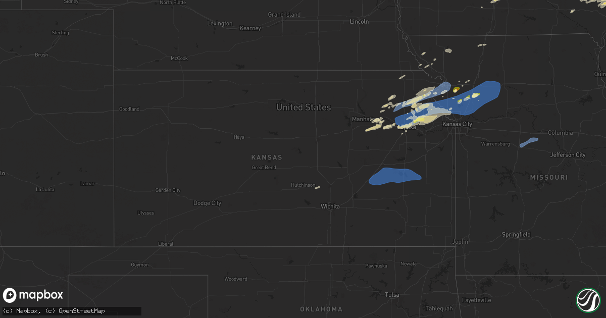
Hail Map in Kansas on October 24, 2024
Get this storm
October 24 map
$229
one time, instant access
Download today. No call, no setup
Keep the $229
Bought the map and want the full workflow? Apply the entire $229 to a subscription within 7 days. None of it is wasted.
Every map, not just this one
This buys you this map. Subscription and you get every map we run, in the markets you choose from a few cities to whole states to nationwide. Plus real-time alerts the moment a storm fires.
Contact data
Name, contact info, occupancy, even credit band for addresses in the footprint. You go from where it hit to who to call.
Become the source they trust
Unlimited branding weather history reports on demand. You already have the documented answer ready for the property owner, and you are the one who showed up with it.
Property data and RoofTrace estimates
Pull up any address you have got, its value and the exact code rules for that jurisdiction, straight from One Click Code. Then RoofTrace estimates the squares, pitch, and roof value, priced the way you price.
Storm reports in Kansas
Kansas
| Date | Description |
|---|---|
| 10/24/20246:38 PM CDT | A local report indicates 1.00 inch wind near Wamego |
| 10/23/20249:41 PM CDT | Downed trees and limbs near 95th and state line. Time estimated from radar. |
| 10/23/20249:41 PM CDT | Downed tree and limbs near 95th and state line. Time estimated from radar. |
| 10/23/20249:07 PM CDT | Delayed report. Downed tree and wires near 46th street. Time estimated from radar. |
| 10/23/20249:03 PM CDT | A local report indicates 60 MPH wind near 1 WNW Burlington |
| 10/23/20249:01 PM CDT | Downed tree and wires near lyons avenue. Time estimated from radar. |
| 10/23/20248:51 PM CDT | Delayed report. Social media photo of a downed tree near 142nd street and riverview avenue. Time estimated from radar. |
| 10/23/20248:51 PM CDT | Downed tree blocking the road near the intersection of 123rd street and polfer road. Time estimated from radar. |
| 10/23/20248:43 PM CDT | Several large trees down in lansing. Time estimated from radar. |
| 10/23/20248:43 PM CDT | Downed power lines and power outages near lansing. Time estimated from radar. |
| 10/23/20248:43 PM CDT | Kemp emporia municipal airport. |
| 10/23/20248:27 PM CDT | Large tree blown down. Time estimated from radar. |
| 10/23/20248:26 PM CDT | Personal weather station. |
| 10/23/20248:20 PM CDT | A local report indicates 60 MPH wind near Oskaloosa |
| 10/23/20248:20 PM CDT | Portion of metal roof blown off convenience store. Time estimated. |
| 10/23/20248:20 PM CDT | A local report indicates 60 MPH wind near Nortonville |
| 10/23/20248:15 PM CDT | Time confirmed from radar. |
| 10/23/20248:11 PM CDT | Time estimated from radar. |
| 10/23/20248:06 PM CDT | Ktop billard airport. |
| 10/23/20248:00 PM CDT | A local report indicates 60 MPH wind near Topeka |
| 10/23/20247:56 PM CDT | Social media report of power poles downed near troy. Time estimated from radar. |
| 10/23/20247:46 PM CDT | Downed tree limbs and wires and power outages reported in the atchison area. Time estimated from radar. |
| 10/23/20247:45 PM CDT | Downed tree limbs and wires reported in lancaster. Time estimated from radar. |
| 10/23/20247:43 PM CDT | A local report indicates 1.00 inch wind near Lancaster |
| 10/23/20247:40 PM CDT | A local report indicates 68 MPH wind near Lancaster |
| 10/23/20247:39 PM CDT | Measured from private weather station. |
| 10/23/20247:35 PM CDT | Downed trees and limbs in effingham. Time estimated from radar. |
| 10/23/20247:35 PM CDT | Delayed report. Several tree limbs blown down and minor property damage at a residence near denton. Time estimated from radar. |
| 10/23/20247:35 PM CDT | A local report indicates 60 MPH wind near 3 ENE Hoyt |
| 10/23/20247:05 PM CDT | Personal weather station. |
Cities Impacted by Hail Map on October 24, 2024
- Klemme, IA
- Thornton, IA
- Garner, IA
- Alexander, IA
- Clear Lake, IA
- New Ulm, MN
- Ventura, IA
- Meservey, IA
- Mason City, IA
- Rockwell, IA
- Nicollet, MN
- Nora Springs, IA
- Osage, IA
- Rudd, IA
- Hartford, IA
- Swan, IA
- Platte City, MO
- Runnells, IA
- Kansas City, MO
- Gower, MO
- Agency, MO
- Havensville, KS
- Dallas Center, IA
- Trimble, MO
- Onaga, KS
- Wamego, KS
- Plattsburg, MO
- Belvue, KS
- Granger, IA
- Woodward, IA
- Madrid, IA
- Polk City, IA
- Craig, MO
- Alma, KS
- Manhattan, KS
- Lynnville, IA
- Sully, IA
- Burrton, KS
- Goff, KS
- Soldier, KS
- Reasnor, IA
- Pella, IA
- Monroe, IA
- Halstead, KS
- Lathrop, MO
- Searsboro, IA
- Grinnell, IA
- Slater, IA
- Alta Vista, KS
- Montezuma, IA
- Malcom, IA
- Sabetha, KS
- Brooklyn, IA
- Junction City, KS
- Circleville, KS
- Delia, KS
- Emmett, KS
- Holton, KS
- Polo, MO
- Paxico, KS
- Newton, KS
- McFarland, KS
- Turney, MO
- Graham, MO
- Morrill, KS
- Mayetta, KS
- Deep River, IA
- Rhodes, IA
- Melbourne, IA
- Sigourney, IA
- Fairfax, MO
- Horton, KS
- Forest City, MO
- Mound City, MO
- Oregon, MO
- Keota, IA
- Harper, IA
- Williamsburg, IA
- North English, IA
- Millersburg, IA
- Effingham, KS
- Muscotah, KS
- Denison, KS
- Valley Falls, KS
- Parnell, IA
- South English, IA
- Webster, IA
- Maple Hill, KS
- Topeka, KS
- Smithville, MO
- Everest, KS
- Maryville, MO
- Barnard, MO
- Lancaster, KS
- Whiting, KS
- Denton, KS
- Troy, KS
- Maitland, MO
- Cummings, KS
- Atchison, KS
- Brighton, IA
- Washington, IA
- Richland, IA
- Fairfield, IA
- Rossville, KS
- Wellman, IA
- Kalona, IA
- Bendena, KS
- Nortonville, KS
- Conception Junction, MO
- Ravenwood, MO
- Oxford, IA
- Meriden, KS
- Perry, IA
- Saint Joseph, MO
- Wathena, KS
- Ozawkie, KS
- Solon, IA
- De Kalb, MO
- Faucett, MO
- Ainsworth, IA
- Wayland, IA
- Dearborn, MO
- Ridgeway, MO
- Martinsville, MO
- Auburn, KS
- Grantville, KS
- Winchester, KS
- Eagleville, MO
- Riverside, IA
- Easton, MO
- Clarksdale, MO
- Stewartsville, MO
- Hoyt, KS
- Oskaloosa, KS
- Perry, KS
- Lone Tree, IA
- Mount Pleasant, IA
- Crawfordsville, IA
- Columbus Junction, IA
- Winfield, IA
- Conesville, IA
- Nichols, IA
- McLouth, KS
- Easton, KS
- Rushville, MO
- Elwood, KS
- Silver Lake, KS
- Mount Union, IA
- Columbus City, IA
- Morning Sun, IA
- Wapello, IA
- Letts, IA
- New Virginia, IA
- Osceola, IA
- Tonganoxie, KS
- Leavenworth, KS
- Maysville, MO
- Osborn, MO
- Lawrence, KS
- Grandview, IA
- Muscatine, IA
- Bedford, IA
- Victor, IA
- Hartwick, IA
- Fort Leavenworth, KS
- Cameron, MO
- Milo, IA
- Indianola, IA
- Lucas, IA
- New Boston, IL
- Illinois City, IL
- Truro, IA
- Lacona, IA
- Liberty Center, IA
- Edgerton, MO
- Fruitland, IA
- Waldron, MO
- Farley, MO
- Lansing, KS
- Taylor Ridge, IL
- South Amana, IA
- Marengo, IA
- Guernsey, IA
- Aledo, IL
- Reynolds, IL
- Joy, IL
- Knoxville, IA
- Yarmouth, IA
- Mediapolis, IA
- Tiffin, IA
- Homestead, IA
- Belle Plaine, IA
- North Liberty, IA
- Amana, IA
- Oakville, IA
- Keithsburg, IL
- Liberty, MO
- Camden Point, MO
- Weston, MO
- Excelsior Springs, MO
- Holt, MO
- Kingston, MO
- Lawson, MO
- Kearney, MO
- Hamilton, MO
- Kidder, MO
- Orrick, MO
- Cowgill, MO
- Rayville, MO
- Richmond, MO
- Missouri City, MO
- Mooresville, MO
- Breckenridge, MO
- Ludlow, MO
- Dawn, MO
- Gallatin, MO
- Braymer, MO
- Chillicothe, MO
- Utica, MO
- Orion, IL
- Coal Valley, IL
- Sherrard, IL
- Milan, IL
- Prairie City, IA
- Ladora, IA
- Thayer, IA
- Atkins, IA
- Prole, IA
- Saint Charles, IA
- Norway, IA
- Ackworth, IA
- Lynn Center, IL
- Fairfax, IA
- Walford, IA
- Iowa City, IA
- Cambridge, IL
- Osco, IL
- New Windsor, IL
- North Henderson, IL
- Seaton, IL
- Clinton, IA
- West Liberty, IA
- West Branch, IA
- Rio, IL
- Alpha, IL
- Woodhull, IL
- Matherville, IL
- Libertyville, IA
- Batavia, IA
- West Chester, IA
- Andover, IL
- Ophiem, IL
- Geneseo, IL
- Otterville, MO
- Sedalia, MO
- Smithton, MO
- Pilot Grove, MO
- Bunceton, MO
- Cassoday, KS
- Matfield Green, KS
- Burns, KS
- Eureka, KS
- El Dorado, KS
- Olpe, KS
- Madison, KS
- Emporia, KS
- Hartford, KS
- Neosho Rapids, KS
- Gridley, KS
- Burlington, KS
- Waverly, KS
- Lebo, KS
- Le Roy, KS
- Westphalia, KS
- Garnett, KS
- Welda, KS
- Colony, KS
- Walcott, IA
- Calamus, IA
- Dixon, IA
- New Liberty, IA
- Prophetstown, IL
- Oneida, IL
- Davenport, IA


