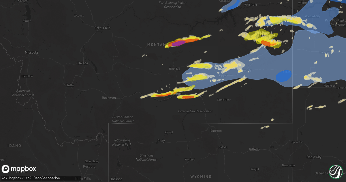
Hail Map on August 7, 2025
Get this storm
August 7 map
$229
one time, instant access
Download today. No call, no setup
Keep the $229
Bought the map and want the full workflow? Apply the entire $229 to a subscription within 7 days. None of it is wasted.
Every map, not just this one
This buys you this map. Subscription and you get every map we run, in the markets you choose from a few cities to whole states to nationwide. Plus real-time alerts the moment a storm fires.
Contact data
Name, contact info, occupancy, even credit band for addresses in the footprint. You go from where it hit to who to call.
Become the source they trust
Unlimited branding weather history reports on demand. You already have the documented answer ready for the property owner, and you are the one who showed up with it.
Property data and RoofTrace estimates
Pull up any address you have got, its value and the exact code rules for that jurisdiction, straight from One Click Code. Then RoofTrace estimates the squares, pitch, and roof value, priced the way you price.
States Impacted by Hail Map on August 7, 2025
Storm reports
Missouri
| Date | Description |
|---|---|
| 08/07/202510:02 AM CDT | Estimated 60 mph winds north of galt. |
| 08/07/20259:55 AM CDT | Estimated wind gusts up to 65 mph northwest of milan. |
| 08/07/20259:32 AM CDT | Tree limbs downed in harris. |
| 08/07/20259:32 AM CDT | Tree limbs downed in harris. |
| 08/07/20259:26 AM CDT | Large tree limbs downed in newtown. |
| 08/07/20259:00 AM CDT | Structure damaged and power pole snapped on west side of mercer. |
| 08/07/20259:00 AM CDT | Wires down and power outage reported in mercer. Estimated winds over 50 mph. |
| 08/07/20258:57 AM CDT | Trees uprooted just south of the iowa state line along us highway 65 north of mercer. |
Kansas
| Date | Description |
|---|---|
| 08/07/20256:45 PM CDT | Photos show portion of a wooden fence blown down... Along with sporadic downed tree limbs throughout town. |
| 08/07/20256:41 PM CDT | Public report of hail up to 1-1.25 inches in bird city. |
| 08/07/20252:45 AM CDT | Site ashley_farm |
| 08/07/202512:10 AM CDT | Various damage associated with heat burst including a tree blown down... Bent antenna tower and tree limb damage. Time estimated. |
| 08/06/202511:29 PM CDT | Ks-ludell3n reported 69 mph gust. |
| 08/06/202511:10 PM CDT | Awos station kadt 1 nnw atwood. |
| 08/06/202511:10 PM CDT | Ks-ludell3n reported 60 mph gust. |
| 08/06/202511:05 PM CDT | K5adt reported 63 mph gust. |
| 08/06/202511:00 PM CDT | Kadt awos reported 52 knots gust. |
| 08/06/202510:50 PM CDT | K5adt reported 63 mph gust. |
| 08/06/20257:45 PM CDT | Delayed report of estimated 2 inch hail in bird city with photo. Multiple stones around 1-1.5 inches. Time estimated. |
| 08/06/20257:05 PM CDT | Public report of 2 trees and 2 large branches knocked over in bird city. |
| 08/06/20257:00 PM CDT | Corrects previous wildfire report from bird city. Public report of large steel |
| 08/06/20257:00 PM CDT | Corrects previous wildfire report from bird city. Public report of large steel tank rolled. Time estimated. |
| 08/06/20257:00 PM CDT | Corrects previous wildfire report from bird city. Public report of large steel tank |
South Dakota
| Date | Description |
|---|---|
| 08/07/20254:26 AM CDT | Asos station kabr aberdeen rgnl ap. |
| 08/07/20254:07 AM CDT | A local report indicates 60 MPH wind near Faulkton |
| 08/07/20253:41 AM CDT | Mesonet station 212 agar |
| 08/07/20253:36 AM CDT | Mesonet station 56 tolstoy |
| 08/07/20253:25 AM CDT | Sdsu mesonet gettysburg west. |
| 08/07/20253:21 AM CDT | Mesonet station 157 forest city |
| 08/07/20253:20 AM CDT | Mesonet station bwls2 bowdle |
| 08/07/20253:16 AM CDT | Mesonet station 216 bowdle |
| 08/07/20253:15 AM CDT | A local report indicates 67 MPH wind near 2 NNE Hosmer |
| 08/07/20253:15 AM CDT | Mesonet station lrms2 lowry 2s |
| 08/07/20252:39 AM CDT | A local report indicates 60 MPH wind near 1 SSE Artas |
| 08/07/20252:39 AM CDT | Corrects previous tstm wnd gst report from 1 sse artas. |
| 08/07/20252:25 AM CDT | Corrects previous tstm wnd gst report from 6 n herreid. Corrects previous tstm wnd gst report from 6 n herreid. |
| 08/07/20252:25 AM CDT | Corrects previous tstm wnd gst report from 6 n herreid. |
| 08/07/20252:06 AM CDT | Mesonet station 205 mclaughlin |
| 08/07/20252:06 AM CDT | Mesonet station grrs2 bullhead 10 s. |
Michigan
| Date | Description |
|---|---|
| 08/07/20256:41 PM CDT | Report on fakebook displayed individual holding large hail stone. The |
| 08/07/20256:41 PM CDT | Report on fakebook displayed individual holding large hail stone. They stated that it was 2 inches in diameter. |
| 08/07/20256:10 PM CDT | Via x/twitter. |
| 08/07/20256:00 PM CDT | Corrects previous hail report from lachine. Report on fakebook displayed individual holding large hail stone. They stated that it was 2 inches in diameter. |
| 08/07/20253:00 PM CDT | A local report indicates 1.00 inch wind near 2 E Owendale |
| 08/06/20257:31 PM CDT | Face port report with a 2 inch hail stone near misery bay east of alpena. |
| 08/06/20257:31 PM CDT | Corrects previous hail report from 6 e alpena. Facebook report with a 2 inch hail stone near misery bay... East of alpena. |
Montana
| Date | Description |
|---|---|
| 08/07/20256:59 PM CDT | A local report indicates 1.25 inch wind near 2 ENE Billings |
| 08/07/20256:56 PM CDT | Wind is based on mesonet and velocity data combined with multiple public estimated reports in the area. |
| 08/07/20256:52 PM CDT | A local report indicates 1.00 inch wind near 1 WNW Billings |
| 08/07/20256:50 PM CDT | Nws employees surveyed multiple structures with roof and siding damage... A building frame that was knocked down and a large camper that had been flipped on its side. D |
| 08/07/20256:50 PM CDT | Report from mping: half dollar |
| 08/07/20256:50 PM CDT | Wind gusted to 80 mph with heavy rain for three minutes. Rainfall=0.44 inches. Electric power still out this morning. |
| 08/07/20256:49 PM CDT | Corrects previous hail report from 2 ene billings. |
| 08/07/20256:48 PM CDT | Storms generated 2 inch rainfall in under 2 hrs with wind gusts to 60 mph. Power out in the area. |
| 08/07/20256:46 PM CDT | Corrects previous hail report from 1 wnw billings. |
| 08/07/20256:46 PM CDT | Some hail drifts also reported. |
| 08/07/20256:39 PM CDT | A local report indicates 1.00 inch wind near 7 W Billings |
| 08/07/20256:39 PM CDT | Corrects previous hail report from 4 w billings. Some hail drifts also reported. |
| 08/07/20256:38 PM CDT | Corrects previous hail report from 6 w billings. Facebook comment. |
| 08/07/20256:33 PM CDT | A local report indicates 1.50 inch wind near 8 NNW Laurel |
| 08/07/20256:33 PM CDT | Corrects previous hail report from 8 ese molt. Facebook comment. |
| 08/07/20256:30 PM CDT | A local report indicates 1.50 inch wind near 1 ESE Billings |
| 08/07/20256:28 PM CDT | Corrects previous hail report from 8 nnw laurel. |
| 08/07/20256:22 PM CDT | A local report indicates 1.50 inch wind near 7 SE Molt |
| 08/07/20256:20 PM CDT | Large hail lasted 10 min. |
| 08/07/20254:29 PM CDT | Wind shield cracked from falling hail. |
| 08/07/20254:27 PM CDT | Spotter estimated hail up to an inch in size. |
| 08/07/20259:38 AM CDT | The observer indicated that the hail had begun about 15 minutes prior to the call. It was still ongoing. Very little wind. Heavy rain. |
| 08/07/20259:31 AM CDT | One inch hail verified from photo on facebook. |
| 08/07/20259:23 AM CDT | Hail with little to no wind. |
| 08/07/20259:22 AM CDT | A local report indicates 1.00 inch wind near Glendive |
| 08/07/20259:20 AM CDT | Hail lasted about 20 minutes. Largest stones were about 2 inches. |
| 08/07/20259:17 AM CDT | Hail with heavy rain. Report via facebook. |
| 08/07/20257:45 AM CDT | Glendive... Dawson community airport... Mt |
| 08/06/202510:37 PM CDT | Asos station kbhk baker. |
| 08/06/202510:31 PM CDT | Glendive... Dawson community airport... Mt |
| 08/06/20259:15 PM CDT | Asos station kmls miles city. |
| 08/06/20258:59 PM CDT | Mesonet station mccm8 cow creek. |
| 08/06/20258:55 PM CDT | Mesonet station dw8633 lambert. |
| 08/06/20258:48 PM CDT | A local report indicates 1.00 inch wind near Lambert |
| 08/06/20258:45 PM CDT | Dw8633 lambert... Mt |
| 08/06/20258:45 PM CDT | A local report indicates 68 MPH wind near 5 W Hathaway |
| 08/06/20258:40 PM CDT | 3 inch tree limb downed. |
| 08/06/20258:39 PM CDT | Mesonet station ew1247 forsyth. |
| 08/06/20258:38 PM CDT | Additional information to previous tstm wnd gst report from lambert. Accompanied by heavy rain. Windows were lost on some homes with the storm. |
| 08/06/20258:38 PM CDT | Accompanied by heavy rain. |
| 08/06/20258:35 PM CDT | A local report indicates 60 MPH wind near 3 E Forsyth |
| 08/06/20258:10 PM CDT | A local report indicates 64 MPH wind near Sarpy Creek Mesonet |
| 08/06/20258:05 PM CDT | A local report indicates 1.00 inch wind near Hardin |
| 08/06/20258:00 PM CDT | Mesonet station mting 1.6 w ingomar |
| 08/06/20258:00 PM CDT | A local report indicates 1.00 inch wind near 2 WSW Hardin |
| 08/06/20257:55 PM CDT | Corrects previous non-tstm wnd gst report from 3 ene wolf point. Asos station kolf wolf point airport. |
| 08/06/20257:52 PM CDT | Facebook comment. |
| 08/06/20257:20 PM CDT | Facebook comment. |
| 08/06/20257:16 PM CDT | 0.12 in rain. |
| 08/06/20257:14 PM CDT | Facebook comment. |
| 08/06/20257:00 PM CDT | Corrects previous hail report from shepherd. Facebook comment. |
Louisiana
| Date | Description |
|---|---|
| 08/07/20255:45 PM CDT | Law enforcement reported of power lines down on george rouyea road near cannon road. |
| 08/07/20255:02 PM CDT | Law enforcement reported a tree down on fish hatchery road near lacombe. |
Minnesota
| Date | Description |
|---|---|
| 08/07/20256:15 AM CDT | Tree damage at the golf course. Time estimated from radar. |
| 08/07/20256:15 AM CDT | Tree damage at the golf course. Time e |
| 08/07/20255:30 AM CDT | Power pole down. Time estimated from radar. |
| 08/07/20254:50 AM CDT | Tree damage around town. Time estimated from radar. |
| 08/07/20254:50 AM CDT | Tree damage around town. Time |
| 08/07/20254:50 AM CDT | Tree damage. Time estimated from radar. |
| 08/07/20254:41 AM CDT | 75 mph wind gust recorded at the surface. |
| 08/07/20254:40 AM CDT | Personal weather station reported. |
| 08/07/20254:40 AM CDT | Tree damage throughout town. Time estimated from radar. |
| 08/07/20254:35 AM CDT | Crookston airport measured peak gust via 1 min observation. |
| 08/07/20254:35 AM CDT | Crookston airport measured peak gust via 1 min observation. |
| 08/07/20254:30 AM CDT | Tree damage around town. Time estimated from radar. |
| 08/07/20254:30 AM CDT | Tree damage around town. Time estimated from radar. |
Nebraska
| Date | Description |
|---|---|
| 08/07/20256:22 AM CDT | Occurred on north edge of mccook. Estimated time and speed of the wind gust |
| 08/07/20256:22 AM CDT | Occurred on north edge of mccook. Estimated time and speed of the wind gust. Also stated the temperatures were very hot when the winds occurred. |
| 08/07/20256:22 AM CDT | Occurred on north edge of mccook. Estimated time and s |
Iowa
| Date | Description |
|---|---|
| 08/07/20258:58 AM CDT | Delayed report. Damage to tin buildings in town. Trailers shifted on foundation. Tree limbs down and some trees uprooted. Time estimated from radar. |
North Dakota
| Date | Description |
|---|---|
| 08/07/20256:20 PM CDT | Hail estimated in size... But significant crop damage occurred in near mature wheat and soybeans. Very little wind. |
| 08/07/20255:16 PM CDT | Quarter size hail falling in rolla at the time of report. |
| 08/07/20259:50 AM CDT | Corrects previous non-tstm wnd gst report from 2 sw moorhead. Mesonet station mn098 moorhead mn dot. |
| 08/07/20254:20 AM CDT | Ndawn mesonet at emerado |
| 08/07/20254:20 AM CDT | Ndawn mesonet at |
| 08/07/20254:15 AM CDT | A tree 4-5 inches in diameter and ~ 10 ft tall was reported down. |
| 08/07/20254:12 AM CDT | Grand forks air force base recorded wind gust of 91 mph. |
| 08/07/20254:12 AM CDT | Corrects previous non-tstm wnd gst report from 6 wnw grand forks. Asos station kgfk grand forks ap nd. |
| 08/07/20254:03 AM CDT | At i-29 near buxton... A semi was reported blown over by the public |
| 08/07/20254:00 AM CDT | Report of a power line down in mayville. Winds estimated at 75 mph. Time estimated via radar. |
| 08/07/20253:56 AM CDT | Report at 10 meters. 58 mph at the surface. |
| 08/07/20253:55 AM CDT | Tree damage around town. Time estimated from radar. |
| 08/07/20253:55 AM CDT | Corrects previous non-tstm wnd gst report from 3 e mayville. Mesonet station 325679 mayville nd ndawn. |
| 08/07/20253:55 AM CDT | 10 meter wind sensor at the casselton ndawn. |
| 08/07/20253:51 AM CDT | Report at 10 meters. 53 mph at the surface. |
| 08/07/20253:50 AM CDT | Corrects previous non-tstm wnd gst report from 2 e logan center. Mesonet station 325332 logan center nd ndawn. |
| 08/07/20253:50 AM CDT | Tree damage around town. Time estimated from radar. |
| 08/07/20253:40 AM CDT | Tree damage around town... Also report of a damaged play shed. Time estimated from radar. |
| 08/07/20253:36 AM CDT | Hope ndawn mesonet recorded 63 mph wind gust near the surface. |
| 08/07/20253:33 AM CDT | Damage to a shop from strong winds was reported. Time estimated via radar. |
| 08/07/20253:09 AM CDT | A local report indicates 74 MPH wind near Valley City |
| 08/07/20252:55 AM CDT | Glenfield nddot site. Time estimated from radar. |
| 08/07/20252:51 AM CDT | Personal weather station. |
| 08/07/20252:50 AM CDT | Ndawn station ypsilanti 2e. Report at 10 meters... 51 mph at the surface. |
| 08/07/20252:45 AM CDT | Nddot site. Time estimated from radar. |
| 08/07/20252:45 AM CDT | Ndawn station courtenay 5w. Report at 10 meters... 63 mph observed at the surface. |
| 08/07/20252:41 AM CDT | Asos station kjms jamestown airport. |
| 08/07/20252:40 AM CDT | Measured wind gust at private weather station. |
| 08/07/20252:40 AM CDT | Ndawn station courtenay 5w. Report at 10 meters... 43 mph observed at the surface. |
| 08/07/20252:38 AM CDT | Multiple power lines down in yard and part of shop roof off. Radar estimated time. |
| 08/07/20252:37 AM CDT | Measured wind gust at private weather station. |
| 08/07/20252:36 AM CDT | Measured wind gust at private weather station. |
| 08/07/20252:35 AM CDT | Arrowwood raws station. Time estimated from radar. |
| 08/07/20252:29 AM CDT | Raws station arrowwood 2. Time estimated by radar. |
| 08/07/20252:20 AM CDT | Measured wind gust at private weather station. |
| 08/07/20252:17 AM CDT | Measured wind gust at private weather station. |
| 08/07/20252:15 AM CDT | Measured wind gust at private weather station. |
| 08/07/20252:11 AM CDT | Nddot station medina i-94 mp. Time estimated by radar. |
| 08/07/20252:10 AM CDT | Measured wind gust at private weather station. |
| 08/07/20251:50 AM CDT | Ndawn station robinson 3nnw. Report at 10 meters... 57 mph reported at the surface. |
| 08/07/20251:40 AM CDT | Nddot station us-83 hazelton ess. Time estimated by radar. |
| 08/07/20251:40 AM CDT | Mesonet station ts633 long lake nwr. Time estimated by radar. |
| 08/07/20251:34 AM CDT | Raws site tatanka prairie nd. Time estimated by radar. |
| 08/07/20251:18 AM CDT | A local report indicates 68 MPH wind near 2 NE Bismarck |
| 08/07/20251:15 AM CDT | Asos station kbis bismarck airport. |
| 08/07/20251:09 AM CDT | Mesonet station cw2059 6 n bismarck. |
| 08/07/202512:55 AM CDT | Estimated wind gust speed. Time estimated from radar. |
| 08/07/202512:34 AM CDT | Ndawn station elgin 10nw. Reported at 10 meters... 51 mph observed at the surface. |
| 08/07/202512:24 AM CDT | Ndawn station manning 4sw. Report at 10 meters... 61 mph observed at the surface. Report was made well behind the line of thunderstorms... With no lightning in the area |
| 08/07/202512:15 AM CDT | Ndawn station manning 4sw. Report at 10 meters... 57 mph observed at the surface. |
| 08/07/202512:11 AM CDT | Ndawn station halliday 4n. Reported at 10 meters... 56 mph observed at the surface. |
| 08/07/202512:10 AM CDT | Ndawn station lefor 10se. Report at 10 meters... 59 mph observed at the surface. |
| 08/06/202511:51 PM CDT | Private weather station observation relayed via emergency manager. |
| 08/06/202511:43 PM CDT | Ndawn station new england 5w. Report at 10 meters... 47 mph observed at the surface. |
| 08/06/202511:39 PM CDT | A local report indicates 63 MPH wind near 3 W Buffalo Springs |
| 08/06/202511:30 PM CDT | A local report indicates 62 MPH wind near 6 S Westhope |
| 08/06/202511:25 PM CDT | Nda |
| 08/06/202511:25 PM CDT | Ndawn station amidon 1ne. Report at 10 meters... 54 mph observed at the surface. |
| 08/06/202511:15 PM CDT | Mesonet station amdn8 sand creek. Time estimated by radar. |
| 08/06/202511:14 PM CDT | Private weather station measured wind gust. |
| 08/06/202511:04 PM CDT | Power poles down. Radar estimated time. |
| 08/06/202510:55 PM CDT | Ndawn station marmarth 2n. Report at 10 meters... 58 mph observed at the surface. |
| 08/06/202510:40 PM CDT | Emergency manager relays image of a camper-trailer flipped on highway 2... At the williams county... Mountrail county line. At 10:20 pm ct... The line of storms was pro |
| 08/06/202510:25 PM CDT | Ndawn station ray 4n. Reported at 10 meters... 61 mph observed at the surface. |
| 08/06/202510:25 PM CDT | Corrects previous report. Ndawn station 3 n ray. Report at 10 meters... 61 mph observed at the surface. |
| 08/06/202510:24 PM CDT | Nddot station grassy butte us-85. Time estimated via radar. |
| 08/06/202510:20 PM CDT | Ndawn station grassy butte 2e. Report at 10 meters... 52 mph at the surface. |
| 08/06/202510:17 PM CDT | Asos station kmot minot airport. |
| 08/06/202510:16 PM CDT | Report relayed through broadcast media of a large tree that fell onto a mobile home and caused 6 large holes in the roof. Believed to have been struck by lightning. Tim |
| 08/06/202510:15 PM CDT | Former nws employee relayed photos of large tree that fell on a camper at roughrider rv park. Camper is totaled. Time estimated from radar. |
| 08/06/20259:55 PM CDT | Awos station k1on 10 s antler. |
| 08/06/20259:31 PM CDT | Awos station k1nn 3 w mohall. |
| 08/06/20259:30 PM CDT | Nddot station blaisedell us-2. |
| 08/06/20259:15 PM CDT | Ndawn station shell lake 2se. Report at 10 meters... 48 mph observed at the surface. |
| 08/06/20259:15 PM CDT | Ndawn station s |
| 08/06/20259:07 PM CDT | Ndawn station palermo 8n. Report at surface. |
| 08/06/20259:03 PM CDT | Local ham radio operator report. |
| 08/06/20258:56 PM CDT | New town dot site. |
| 08/06/20258:41 PM CDT | Stanley 8sw ndawn. |
| 08/06/20258:33 PM CDT | Emergency manager sent video showing rain and hail (up |
| 08/06/20258:33 PM CDT | Emergency manager sent video showing rain and hail |
| 08/06/20258:28 PM CDT | Ndawn station powers lake 6se. Report at 10 meters... 51 mph observed at the surface. |
| 08/06/20258:22 PM CDT | Emergency manager also reports small hail the size of pennies and lots of rain. Visibility is down to around 300ft |
| 08/06/20258:18 PM CDT | Ndawn station dry fork 1se. Report at 10 meters... 55 mph at the surface. |
| 08/06/20258:15 PM CDT | A local report indicates 59 MPH wind near 2 ESE Tioga |
| 08/06/20258:12 PM CDT | Report from mping: quarter |
| 08/06/20257:45 PM CDT | A local report indicates 1.25 inch wind near Columbus |
| 08/06/20257:38 PM CDT | Fire chief reports 1 inch |
| 08/06/20257:38 PM CDT | Fire chief r |
| 08/06/20257:38 PM CDT | Fire chief reports 1 inch hail. Relayed through emergency manager. (b |
| 08/06/20257:36 PM CDT | A local report indicates 1.00 inch wind near 1 N Lignite |
| 08/06/20257:16 PM CDT | A local report indicates 1.25 inch wind near 3 E Columbus |
| 08/06/20257:15 PM CDT | Corrects previous report from 8 nnw corinth. Accompanied by lots of small hail and some quarter size hail. Crop damage. |
| 08/06/20257:15 PM CDT | Accompanied by lots of small hail but some quarters. Crop damage. |
Cities Impacted by Hail Map on August 7, 2025
- Limon, CO
- Lindsay, MT
- Terry, MT
- Minburn, IA
- Adel, IA
- Waukee, IA
- Dallas Center, IA
- Osceola, IA
- Murray, IA
- Weldon, IA
- Humeston, IA
- Glendive, MT
- Bloomfield, MT
- Woodburn, IA
- Van Wert, IA
- De Soto, IA
- Van Meter, IA
- Booneville, IA
- Brockway, MT
- Grand River, IA
- Thayer, IA
- Ellston, IA
- West Des Moines, IA
- Circle, MT
- Leon, IA
- Davis City, IA
- Lineville, IA
- Decatur, IA
- Garden Grove, IA
- Winterset, IA
- Cumming, IA
- Cainsville, MO
- Clive, IA
- Urbandale, IA
- Truro, IA
- Peru, IA
- Allerton, IA
- Saint Charles, IA
- Mercer, MO
- Clio, IA
- Bouton, IA
- Woodward, IA
- Granger, IA
- Princeton, MO
- New Virginia, IA
- Powersville, MO
- Lucerne, MO
- Newtown, MO
- Pollock, MO
- Harris, MO
- Ridgeway, MO
- Higbee, MO
- Milan, MO
- Clark, MO
- Spickard, MO
- Moberly, MO
- Humphreys, MO
- Galt, MO
- Trenton, MO
- Laredo, MO
- Browning, MO
- Linneus, MO
- Purdin, MO
- Chula, MO
- New Boston, MO
- Green Castle, MO
- Winigan, MO
- Brookfield, MO
- Bucklin, MO
- Kirksville, MO
- Ethel, MO
- Waynesville, MO
- Fort Leonard Wood, MO
- Fortuna, ND
- Laclede, MO
- Chillicothe, MO
- Crosby, ND
- Chariton, IA
- Corydon, IA
- Hale, MO
- Owendale, MI
- Pigeon, MI
- Sebewaing, MI
- Gagetown, MI
- Cottonwood, ID
- Elkton, MI
- Buffalo, MT
- Ferdinand, ID
- Nezperce, ID
- Greencreek, ID
- Morganton, GA
- Suches, GA
- Blue Ridge, GA
- Orofino, ID
- Englewood, FL
- Cass City, MI
- Craigmont, ID
- Grass Range, MT
- Redstone, MT
- Ponchatoula, LA
- Robert, LA
- Winnett, MT
- Huntington, VT
- Madisonville, LA
- Covington, LA
- Deford, MI
- Flaxville, MT
- Rolla, ND
- Livingston, LA
- Brusett, MT
- Reserve, MT
- Greycliff, MT
- Antelope, MT
- Owaneco, IL
- Hillman, MI
- Denham Springs, LA
- Stonington, IL
- Taylorville, IL
- Assumption, IL
- Plentywood, MT
- McLeod, MT
- Bird City, KS
- Prairieville, LA
- Pearland, TX
- Reed Point, MT
- Lachine, MI
- Dagmar, MT
- Sand Springs, MT
- Big Timber, MT
- Columbus, MT
- Herron, MI
- Madison, AL
- Moweaqua, IL
- Manvel, TX
- Molt, MT
- Park City, MT
- Westby, MT
- Dalton, GA
- Chatsworth, GA
- Grenora, ND
- Rocklake, ND
- Macon, IL
- Blue Mound, IL
- Rosharon, TX
- Huntsville, AL
- Fresno, TX
- Laurel, MT
- Jordan, MT
- Billings, MT
- Lincoln, MI
- Spruce, MI
- Barton City, MI
- Resaca, GA
- Rapelje, MT
- Ambrose, ND
- Alamo, ND
- Columbus, ND
- Stafford, TX
- Missouri City, TX
- Shepherd, MT
- Sarles, ND
- Hubbard Lake, MI
- Huntley, MT
- Worden, MT
- Ballantine, MT
- Alpena, MI
- Black River, MI
- Posen, MI
- Froid, MT
- Hansboro, ND
- Saint Francis, KS
- Nenzel, NE
- Kilgore, NE
- Hawks, MI
- Fort Peck, MT
- Curran, MI
- Zahl, ND
- McDonald, KS
- Flaxton, ND
- Portal, ND
- Wolf Point, MT
- Nashua, MT
- Williston, ND
- Musselshell, MT
- Lignite, ND
- Wildrose, ND
- Port Allen, LA
- Pompeys Pillar, MT
- Acton, MT
- Hardin, MT
- Custer, MT
- Ingomar, MT
- Hysham, MT
- Richey, MT
- Comins, MI
- Crookston, NE
- Vida, MT
- Atlanta, MI
- Frazer, MT
- Glasgow, MT
- Tioga, ND
- Mcgregor, ND
- Ray, ND
- Noonan, ND
- Bainville, MT
- Epping, ND
- Forsyth, MT
- Powers Lake, ND
- Crow Agency, MT
- Bighorn, MT
- Bowbells, ND
- Sanders, MT
- Colstrip, MT
- Rosebud, MT
- Lambert, MT
- Stanley, ND
- Kenmare, ND
- Tolley, ND
- Sherwood, ND
- Ross, ND
- White Earth, ND
- Hathaway, MT
- Volborg, MT
- Culbertson, MT
- Savage, MT
- Sidney, MT
- Miles City, MT
- Kinsey, MT
- Angela, MT
- Palermo, ND
- Mohall, ND
- Carpio, ND
- Lansford, ND
- Crane, MT
- Fairview, MT
- Donnybrook, ND
- Cartwright, ND
- Maxbass, ND
- Antler, ND
- Plaza, ND
- Berthold, ND
- Des Lacs, ND
- Burlington, ND
- Glenburn, ND
- Minot, ND
- Westhope, ND
- Newburg, ND
- Ismay, MT
- Fallon, MT
- Alexander, ND
- Grassy Butte, ND
- Arnegard, ND
- Watford City, ND
- Minot Afb, ND
- Souris, ND
- Bantry, ND
- Upham, ND
- Deering, ND
- Velva, ND
- Norwich, ND
- Surrey, ND
- Plevna, MT
- Baker, MT
- Ekalaka, MT
- Willard, MT
- Granville, ND
- Voltaire, ND
- Karlsruhe, ND
- Towner, ND
- Kramer, ND
- Bottineau, ND
- New Town, ND
- Killdeer, ND
- Keene, ND
- Mandaree, ND
- Willow City, ND
- Wibaux, MT
- Parshall, ND
- Sentinel Butte, ND
- Beach, ND
- Golva, ND
- Medora, ND
- Belfield, ND
- Fairfield, ND
- Rhame, ND
- Marmarth, ND
- Camp Crook, SD
- Amidon, ND
- Sawyer, ND
- Dunn Center, ND
- Halliday, ND
- Roseglen, ND
- Bowman, ND
- Buffalo, SD
- Atwood, KS
- Ludell, KS
- Rugby, ND
- Herndon, KS
- Oberlin, KS
- Manning, ND
- Dickinson, ND
- South Heart, ND
- New England, ND
- Rolette, ND
- Dunseith, ND
- Belcourt, ND
- Saint John, ND
- Balfour, ND
- Ryder, ND
- Scranton, ND
- Gladstone, ND
- Garrison, ND
- Drake, ND
- Reeder, ND
- Regent, ND
- Richardton, ND
- Lefor, ND
- Taylor, ND
- Dodge, ND
- Hebron, ND
- Beulah, ND
- Zap, ND
- Wolford, ND
- Mylo, ND
- Hazen, ND
- Anamoose, ND
- Coleharbor, ND
- Stanton, ND
- Underwood, ND
- Washburn, ND
- New Salem, ND
- Hettinger, ND
- Mott, ND
- Center, ND
- Glen Ullin, ND
- New Leipzig, ND
- Turtle Lake, ND
- Balta, ND
- Martin, ND
- Esmond, ND
- Bisbee, ND
- Perth, ND
- Elgin, ND
- Carson, ND
- Wilton, ND
- Flasher, ND
- Mandan, ND
- Almont, ND
- Baldwin, ND
- Mercer, ND
- Bismarck, ND
- Regan, ND
- Cando, ND
- Leeds, ND
- York, ND
- Harvey, ND
- Maddock, ND
- Mcclusky, ND
- Raleigh, ND
- Solen, ND
- Saint Anthony, ND
- Menoken, ND
- Sterling, ND
- Shields, ND
- Wing, ND
- Calvin, ND
- Denhoff, ND
- Goodrich, ND
- Minnewaukan, ND
- Churchs Ferry, ND
- Hurdsfield, ND
- Starkweather, ND
- Paradise, MI
- Egeland, ND
- Driscoll, ND
- Tuttle, ND
- Moffit, ND
- Hazelton, ND
- Steele, ND
- Robinson, ND
- Chaseley, ND
- Bowdon, ND
- Dawson, ND
- Tappen, ND
- Penn, ND
- Webster, ND
- Devils Lake, ND
- Pettibone, ND
- Fessenden, ND
- Woodworth, ND
- Medina, ND
- Edmore, ND
- Cathay, ND
- Lawton, ND
- Sykeston, ND
- Carrington, ND
- Pingree, ND
- Sheyenne, ND
- Cleveland, ND
- Jamestown, ND
- Ypsilanti, ND
- Buchanan, ND
- Brocket, ND
- Spiritwood, ND
- Fairdale, ND
- Kensal, ND
- Courtenay, ND
- Glenfield, ND
- Wimbledon, ND
- Cooperstown, ND
- Sutton, ND
- Hannaford, ND
- Sanborn, ND
- Marion, ND
- Dazey, ND
- Litchville, ND
- Rogers, ND
- Valley City, ND
- Hope, ND
- Luverne, ND
- Adams, ND
- Crary, ND
- Kathryn, ND
- Oriska, ND
- Tower City, ND
- Page, ND
- Pillsbury, ND
- Buffalo, ND
- Ayr, ND
- Fingal, ND
- Erie, ND
- Binford, ND
- New Rockford, ND
- Mchenry, ND
- Lakota, ND
- Eckerman, MI
- Hulbert, MI
- Park River, ND
- Mcville, ND
- Finley, ND
- Clifford, ND
- Hatton, ND
- Mayville, ND
- Portland, ND
- Galesburg, ND
- Thompson, ND
- Grand Forks, ND
- Reynolds, ND
- Emerado, ND
- East Grand Forks, MN
- Absaraka, ND
- Amenia, ND
- Buxton, ND
- Arthur, ND
- Hunter, ND
- Blanchard, ND
- Hillsboro, ND
- Wheatland, ND
- Cummings, ND
- Casselton, ND
- Grandin, ND
- Davenport, ND
- Mapleton, ND
- Leonard, ND
- Newberry, MI
- Edinburg, ND
- Niagara, ND
- Petersburg, ND
- Northwood, ND
- Sharon, ND
- Aneta, ND
- Larimore, ND
- Arvilla, ND
- Grand Forks Afb, ND
- Mekinock, ND
- Newaygo, MI
- White Cloud, MI
- Grant, MI
- West Fargo, ND
- Warren, MN
- Gardner, ND
- Caledonia, ND
- Fisher, MN
- Hendrum, MN
- Fargo, ND
- Halstad, MN
- Climax, MN
- Nielsville, MN
- Harwood, ND
- Horace, ND
- Shelly, MN
- Argusville, ND
- Georgetown, MN
- Moorhead, MN
- Perley, MN
- Ada, MN
- Crookston, MN
- Euclid, MN
- Jessie, ND
- Pekin, ND
- Michigan, ND
- Gilby, ND
- Manvel, ND
- Oslo, MN
- Beltrami, MN
- Comstock, MN
- Wolverton, MN
- Dilworth, MN
- Sabin, MN
- Borup, MN
- Glyndon, MN
- Barnesville, MN
- Felton, MN
- Fertile, MN
- Twin Valley, MN
- Rothsay, MN
- Hawley, MN
- Ulen, MN
- Fergus Falls, MN
- Alvarado, MN
- Minto, ND
- Gary, MN
- Mentor, MN
- Lake Park, MN
- Hitterdal, MN
- Thief River Falls, MN
- Saint Hilaire, MN
- Red Lake Falls, MN
- Pelican Rapids, MN
- Elizabeth, MN
- Erhard, MN
- Paris, MI
- Bitely, MI
- Viking, MN
- Erskine, MN
- Alzada, MT
- Naubinway, MI
- Mahnomen, MN
- Waubun, MN
- Bejou, MN
- Winger, MN
- Fosston, MN
- Ogema, MN
- Brooks, MN
- Audubon, MN
- Plummer, MN
- Callaway, MN
- Detroit Lakes, MN
- Oklee, MN
- Trail, MN
- Mcintosh, MN
- Gully, MN
- White Earth, MN
- Naytahwaush, MN
- Vergas, MN
- Lengby, MN
- Rochert, MN
- Frazee, MN
- Ponsford, MN
- Bagley, MN
- Reva, SD
- Big Rapids, MI
- Goodridge, MN
- Gonvick, MN
- Leonard, MN
- Park Rapids, MN
- Shevlin, MN
- Clearbrook, MN
- Prairie City, SD
- Weston, WY
- Lemmon, SD
- Meadow, SD
- Henning, MN
- Alexandria, MN
- Lowry, MN
- Presque Isle, MI
- Rogers City, MI