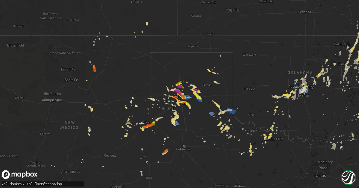
Hail Map on August 11, 2025
Get this storm
August 11 map
$229
one time, instant access
Download today. No call, no setup
Keep the $229
Bought the map and want the full workflow? Apply the entire $229 to a subscription within 7 days. None of it is wasted.
Every map, not just this one
This buys you this map. Subscription and you get every map we run, in the markets you choose from a few cities to whole states to nationwide. Plus real-time alerts the moment a storm fires.
Contact data
Name, contact info, occupancy, even credit band for addresses in the footprint. You go from where it hit to who to call.
Become the source they trust
Unlimited branding weather history reports on demand. You already have the documented answer ready for the property owner, and you are the one who showed up with it.
Property data and RoofTrace estimates
Pull up any address you have got, its value and the exact code rules for that jurisdiction, straight from One Click Code. Then RoofTrace estimates the squares, pitch, and roof value, priced the way you price.
States Impacted by Hail Map on August 11, 2025
Storm reports
North Dakota
| Date | Description |
|---|---|
| 08/11/20255:50 PM CDT | Estimated half dollar to ping pong ball sized hail east of gwinner. Time estimated from radar. |
Oklahoma
| Date | Description |
|---|---|
| 08/11/20255:41 PM CDT | Nickel to quarter size hail reported near us hwy 62 and us hwy 277. |
| 08/11/20255:40 PM CDT | Report from x. |
| 08/11/20255:01 PM CDT | Near ne 23rd and hiwassee rd. |
| 08/11/20254:51 PM CDT | A local report indicates 61 MPH wind near Tinker Air Force Base |
| 08/11/20254:42 PM CDT | Two power poles damaged near se 19th street and bryant ave. Time estimated. ( |
| 08/11/20254:42 PM CDT | Report from mping: quarter |
| 08/11/20254:42 PM CDT | Two power poles damaged near se 19th street and bryant ave. Time estimated. |
| 08/11/20254:40 PM CDT | Multiple power poles damaged near broadway and eastern avenue. Time estimated. |
| 08/11/20254:40 PM CDT | Video of high winds with tree damage near 8th street and bryant ave in moore. |
| 08/11/20254:35 PM CDT | Delayed report. A relayed image showing a tree snapped. Time estimated from radar. |
| 08/11/20254:26 PM CDT | Report from mping: half dollar |
| 08/11/20253:55 PM CDT | At sundance airport. |
| 08/11/20253:55 PM CDT | Delayed report. 3-inch tree branches blown down. Mping report. |
New Mexico
| Date | Description |
|---|---|
| 08/11/20255:25 PM CDT | A local report indicates 1.50 inch wind near Ojo Feliz |
| 08/10/20257:50 PM CDT | Social media report. Time and location estimated. |
Kansas
| Date | Description |
|---|---|
| 08/11/20254:45 PM CDT | Trees and tree limbs down. Estimated 70 mph winds. Time estimated from radar. |
South Carolina
| Date | Description |
|---|---|
| 08/11/20253:38 PM CDT | Saluda county emergency manager reported a couple chicken houses were destroyed and tin from the roof of a building near simmons rd was found a long distance away. Time |
Wisconsin
| Date | Description |
|---|---|
| 08/11/20255:33 AM CDT | About a half a dozen large branches and tops of trees broken off along with two downed/split trees. |
| 08/11/20255:23 AM CDT | Uprooted tree north of sullivan. Other minor tree branches down in the city. |
Minnesota
| Date | Description |
|---|---|
| 08/11/20256:55 PM CDT | Corrects previous non-tstm wnd gst report from 3 sse mahnomen. Mesonet station mn044 mahnomen mn dot. |
| 08/10/20259:10 PM CDT | A local report indicates 1.50 inch wind near 2 NNW Donnelly |
| 08/10/20258:58 PM CDT | A local report indicates 1.50 inch wind near 9 WNW Donnelly |
| 08/10/20258:00 PM CDT | Delayed report: hail sizes ranged from mostly pea sized to a few stones up to quarter sized. |
| 08/10/20257:40 PM CDT | Report relayed on social media. |
| 08/10/20257:40 PM CDT | Report relayed on social media. ( |
Illinois
| Date | Description |
|---|---|
| 08/11/20253:00 AM CDT | Approximately 12 inch oak tree fell on outbuilding. |
| 08/10/20259:46 PM CDT | Multiple large branches broken near batavia road and sauk boulevard on the fermilab campus. At least one tree with a snapped trunk. |
| 08/10/20259:45 PM CDT | Power lines downed just north of butterfield road and eola road on the southeast side of the fermilab complex. Time estimated by radar. |
Iowa
| Date | Description |
|---|---|
| 08/11/20251:44 AM CDT | Large tree snapped near base with several other tree branches down at kent stein park. Time estimated from radar. |
Florida
| Date | Description |
|---|---|
| 08/10/20259:04 PM CDT | Tree down across the road near west highway 318 and hwy 441. Time estimated via radar. |
| 08/10/20257:38 PM CDT | Several trees down along se 132 place. Time estimated via radar. |
South Dakota
| Date | Description |
|---|---|
| 08/10/20258:59 PM CDT | Mesonet station 47 brandt |
| 08/10/20258:23 PM CDT | Mesonet station 291 4n altamont |
Texas
| Date | Description |
|---|---|
| 08/11/20256:26 PM CDT | A local report indicates 59 MPH wind near 1 NNW Lubbock Int. Airp |
| 08/11/20256:23 PM CDT | Motorist driving north stopped due to large hail estimated to be ping pong ball size. Relayed by boys ranch em. |
| 08/11/20256:20 PM CDT | A local report indicates 1.50 inch wind near 4 ENE Panhandle |
| 08/11/20256:08 PM CDT | Hail up to tennis ball size along highway 287 south of masterson. |
| 08/11/20256:05 PM CDT | Photo of tree uprooted on rogers road about 3 miles east-northeast of iowa park sent by a viewer to kfdx. Time estimated. |
| 08/11/20256:04 PM CDT | Media viewer report. |
| 08/11/20255:59 PM CDT | Multiple hail reports were submitted with pictures. Hail sizes ranged between golf ball to 2 inches on the east side of panhandle. Timeframe for hail started at 559 and |
| 08/11/20255:58 PM CDT | A local report indicates 1.00 inch wind near Iowa Park |
| 08/11/20255:50 PM CDT | A local report indicates 2.00 inch wind near 1 N Panhandle |
| 08/11/20255:02 PM CDT | A local report indicates 1.25 inch wind near 1 W Burkburnett |
| 08/10/202511:45 PM CDT | A local report indicates 61 MPH wind near 3 N Hart |
| 08/10/202510:16 PM CDT | A local report indicates 67 MPH wind near 6 SE Wellington |
| 08/10/202510:12 PM CDT | A local report indicates 72 MPH wind near 2 S Lesley |
| 08/10/202510:10 PM CDT | A local report indicates 71 MPH wind near 2 S Lesley |
| 08/10/202510:00 PM CDT | A local report indicates 66 MPH wind near 2 S Lesley |
| 08/10/20258:40 PM CDT | Delayed report. Large tree limbs blown down. Time estimated from radar. |
| 08/10/20258:22 PM CDT | A lot of dime size with a few stones as large as quarters. Trees and vegetation da |
| 08/10/20258:22 PM CDT | A lot of dime size with a few stones as large as qu |
| 08/10/20258:00 PM CDT | A local report indicates 66 MPH wind near Goodnight |
| 08/10/20257:51 PM CDT | A local report indicates 62 MPH wind near Goodnight |
| 08/10/20257:30 PM CDT | Report from mping: ping pong ball |
| 08/10/20257:23 PM CDT | Report from mping: half dollar |
| 08/10/20257:23 PM CDT | Picture from social media. |
| 08/10/20257:23 PM CDT | A local report indicates 60 MPH wind near 4 NNW Lake Tanglewood |
| 08/10/20257:14 PM CDT | A local report indicates 1.00 inch wind near 7 NW Canyon |
| 08/10/20257:12 PM CDT | Report from mping: golf ball |
| 08/10/20257:03 PM CDT | A local report indicates 1.75 inch wind near 5 WNW Amarillo |
| 08/10/20257:03 PM CDT | Report from mping: golf ball |
| 08/10/20257:03 PM CDT | Report from mping: half dollar |
| 08/10/20257:03 PM CDT | *** 1 inj *** golfball size hail fell and result in one known injury. |
Missouri
| Date | Description |
|---|---|
| 08/11/20256:00 PM CDT | Delayed report of roof blown off of barn. Time estimated by radar. |
| 08/10/202510:32 PM CDT | 20 inch diameter trees downed along with several tree limbs. |
| 08/10/20258:32 PM CDT | 3 inch tree limbs broken. |
Cities Impacted by Hail Map on August 11, 2025
- Thayer, KS
- Cherryvale, KS
- Dennis, KS
- Mound Valley, KS
- Big Spring, TX
- Sterling City, TX
- Midland, TX
- Coffeyville, KS
- Edna, KS
- Delaware, OK
- Minco, OK
- Tuttle, OK
- Mustang, OK
- Lenapah, OK
- Guthrie, OK
- Vinita, OK
- Talala, OK
- Pocasset, OK
- Union City, OK
- Nowata, OK
- Oswego, KS
- McCune, KS
- Lakeside, AZ
- Saline, MI
- Welch, OK
- S Coffeyville, OK
- Chickasha, OK
- Amber, OK
- Yukon, OK
- Edmond, OK
- Arcadia, OK
- Piedmont, OK
- Bartlett, KS
- Cleveland, OK
- Mannford, OK
- Sand Springs, OK
- Lawton, OK
- Milan, MI
- Meridian, OK
- Oktaha, OK
- Liberal, MO
- Kim, CO
- Jennings, OK
- Blanchard, OK
- Bethany, MO
- McFall, MO
- Chetopa, KS
- Columbus, KS
- Devol, OK
- Butler, MO
- Rich Hill, MO
- Marlow, OK
- Montezuma, NM
- Bluejacket, OK
- Walters, OK
- Muskogee, OK
- Bronaugh, MO
- Oklahoma City, OK
- Deport, TX
- Stroud, OK
- Drumright, OK
- Bristow, OK
- Cushing, OK
- Jones, OK
- Miami, OK
- Skiatook, OK
- Galena, KS
- Afton, OK
- Randlett, OK
- Iowa Park, TX
- Claremore, OK
- Wellston, OK
- Norman, OK
- Owasso, OK
- Collinsville, OK
- Barnhart, TX
- Carl Junction, MO
- Joplin, MO
- Oronogo, MO
- Yale, OK
- Tulsa, OK
- Catoosa, OK
- Arma, KS
- Barnsdall, OK
- Wichita Falls, TX
- Burkburnett, TX
- Carney, OK
- Tryon, OK
- Chandler, OK
- Asbury, MO
- Plains, TX
- Fairland, OK
- Choctaw, OK
- Spencer, OK
- Webb City, MO
- Mindenmines, MO
- Arcadia, KS
- Meeker, OK
- Eucha, OK
- Oologah, OK
- Newalla, OK
- Buffalo, ND
- Wheatland, ND
- Lovington, NM
- Agra, OK
- Apache, OK
- Seneca, MO
- Harrah, OK
- Mcloud, OK
- Pryor, OK
- Anadarko, OK
- Roseau, MN
- Panhandle, TX
- Elgin, OK
- Jerico Springs, MO
- Stockton, MO
- Badger, MN
- Mora, NM
- Ochelata, OK
- Bartlesville, OK
- Castle, OK
- Paden, OK
- Big Cabin, OK
- Sheldon, ND
- Cogswell, ND
- Vaughn, NM
- Chelsea, OK
- Stirum, ND
- Depew, OK
- Corona, NM
- Hurdsfield, ND
- Masterson, TX
- Adair, OK
- Grandfield, OK
- Ocate, NM
- Guadalupita, NM
- Lisbon, ND
- Littlefield, TX
- Levelland, TX
- Happy, TX
- Stella, MO
- Neosho, MO
- Fort Scott, KS
- Salina, OK
- Electra, TX
- Palermo, ND
- Stanley, ND
- Greenbush, MN
- Gwinner, ND
- Fort Cobb, OK
- Rose, OK
- Sundown, TX
- Boley, OK
- Jenks, OK
- Douglas, AZ
- Gracemont, OK
- Broken Arrow, OK
- Bixby, OK
- Osceola, MO
- Tatum, NM
- Inola, OK
- Lowry City, MO
- El Dorado Springs, MO
- Locust Grove, OK
- Spavinaw, OK
- Amarillo, TX
- Mounds, OK
- Beggs, OK
- Groom, TX
- Okmulgee, OK
- Amherst, TX
- Deepwater, MO
- Forman, ND
- Quinton, OK
- Hughesville, MO
- Elida, NM
- Chouteau, OK
- Twin Valley, MN
- Miami, TX
- Clinton, MO
- Gary, MN
- Mahnomen, MN
- Houstonia, MO
- Morris, OK
- Quincy, MO
- Fessenden, ND
- Harvey, ND
- Rutland, ND
- Indiahoma, OK
- Milnesand, NM
- Checotah, OK
- Collins, MO
- Seymour, TX
- Holliday, TX
- Canyon, TX
- Boynton, OK
- Pritchett, CO
- Weaubleau, MO
- Mcadoo, TX
- Crosbyton, TX
- Stigler, OK
- Seminole, OK
- Hawley, MN
- Mobeetie, TX
- Cayuga, ND
- Haskell, OK
- Council Hill, OK
- Calhoun, MO
- Wildorado, TX
- Lake Park, MN
- Wagoner, OK
- Milnor, ND
- Hobbs, NM
- Dimmitt, TX
- Hart, TX
- Henryetta, OK
- Butte, ND
- Barnesville, MN
- Weleetka, OK
- Hankinson, ND
- Nazareth, TX
- Fort Gibson, OK
- Wahpeton, ND
- Carnegie, OK
- Waubun, MN
- Naytahwaush, MN
- Pelican Rapids, MN
- Toluca, IL
- Coweta, OK
- Warsaw, MO
- Eufaula, OK
- Portales, NM
- Tulia, TX
- Breckenridge, MN
- Telephone, TX
- Windsor, MO
- Lubbock, TX
- Muldrow, OK
- Claude, TX
- Fairmount, ND
- Underwood, ND
- Turtle Lake, ND
- Hulbert, OK
- Sedalia, MO
- Green Ridge, MO
- Rutland, IL
- Floydada, TX
- Campbell, MN
- Knob Noster, MO
- Strang, OK
- Texico, NM
- Washburn, ND
- Wenona, IL
- Muleshoe, TX
- Vega, TX
- Hereford, TX
- Alton, KS
- Clarendon, TX
- Tintah, MN
- Nashua, MN
- Clovis, NM
- Vergas, MN
- Warner, OK
- Roland, OK
- Cannon Afb, NM
- Roswell, NM
- Sisseton, SD
- Paducah, TX
- Cee Vee, TX
- Floyd, NM
- Matador, TX
- Norcross, MN
- Elbow Lake, MN
- Bovina, TX
- Farwell, TX
- Wendell, MN
- Wheaton, MN
- Munday, TX
- Van Buren, AR
- Regan, ND
- Memphis, TX
- Childress, TX
- Lostant, IL
- Melrose, NM
- Fitzhugh, OK
- Mcalester, OK
- Savanna, OK
- Donnelly, MN
- Herman, MN
- Dumont, MN
- Wister, OK
- Talihina, OK
- Red Oak, OK
- Barrett, MN
- Friona, TX
- Wayside, TX
- Kiowa, OK
- Knox City, TX
- Broadview, NM
- Tell, TX
- Goree, TX
- Alma, AR
- Hoffman, MN
- Morris, MN
- Downing, MO
- Clayton, OK
- Olton, TX
- Lelia Lake, TX
- Hedley, TX
- Ravenna, TX
- Calera, OK
- Durant, OK
- Chokio, MN
- Nashoba, OK
- Wellington, TX
- Quail, TX
- Ector, TX
- Bonham, TX
- Lakeview, TX
- Bloomfield, IA
- Drakesville, IA
- Moulton, IA
- Tucumcari, NM
- Pulaski, IA
- Quanah, TX
- Farwell, MN
- Cyrus, MN
- Kensington, MN
- Bard, NM
- Crowell, TX
- Atoka, OK
- Chillicothe, TX
- Milton, IA
- Windom, TX
- Dodd City, TX
- Honey Grove, TX
- San Jon, NM
- Starbuck, MN
- Douds, IA
- Cantril, IA
- Keosauqua, IA
- Dodson, TX
- Lamar, AR
- Hagarville, AR
- Vernon, TX
- Hollis, OK
- Hendrix, OK
- Birmingham, IA
- Gould, OK
- Lowry, MN
- Ivanhoe, TX
- Bennington, OK
- Soper, OK
- Hugo, OK
- Glenwood, MN
- Stockport, IA
- Norman, AR
- Boswell, OK
- Hillsboro, IA
- Bonaparte, IA
- Albany, MN
- Arthur City, TX
- Mount Pleasant, IA
- Salem, IA
- Memphis, MO
- Powderly, TX
- Savoy, TX
- Colbert, OK
- Temple, OK
- Afton, TX
- Hominy, OK
- Ramona, OK
- Booker, TX
- Fletcher, OK
- Pampa, TX
- Bells, TX
- Wewoka, OK
- Idalou, TX
- Bokchito, OK
- Celina, TX
- Okemah, OK
- Canadian, TX
- Fort Sill, OK
- Throckmorton, TX
- Wheatland, OK
- Pewaukee, WI
- Delafield, WI
- Hartland, WI
- Menomonee Falls, WI
- Sussex, WI
- Waukesha, WI
- Lannon, WI
- Milwaukee, WI
- Germantown, WI
- Mequon, WI
- Colgate, WI
- Butler, WI
- Brookfield, WI
- Grafton, WI
- Cedarburg, WI
- New Berlin, WI
- Dousman, WI
- Oconomowoc, WI
- Fort Atkinson, WI
- Jefferson, WI
- Helenville, WI
- Sullivan, WI
- Wales, WI
- Whitewater, WI
- Nashotah, WI
- Okauchee, WI
- Hartford, WI
- Hubertus, WI
- Springlake, TX
- Kress, TX
- Bethany, OK
- Newcastle, OK