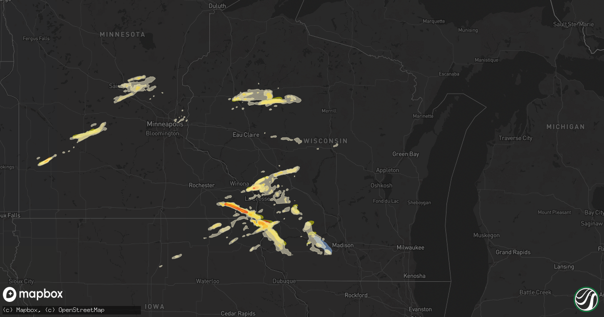
Hail Map in Wisconsin on September 21, 2024
Get this storm
September 21 map
$229
one time, instant access
Download today. No call, no setup
Keep the $229
Bought the map and want the full workflow? Apply the entire $229 to a subscription within 7 days. None of it is wasted.
Every map, not just this one
This buys you this map. Subscription and you get every map we run, in the markets you choose from a few cities to whole states to nationwide. Plus real-time alerts the moment a storm fires.
Contact data
Name, contact info, occupancy, even credit band for addresses in the footprint. You go from where it hit to who to call.
Become the source they trust
Unlimited branding weather history reports on demand. You already have the documented answer ready for the property owner, and you are the one who showed up with it.
Property data and RoofTrace estimates
Pull up any address you have got, its value and the exact code rules for that jurisdiction, straight from One Click Code. Then RoofTrace estimates the squares, pitch, and roof value, priced the way you price.
Storm reports in Wisconsin
Wisconsin
| Date | Description |
|---|---|
| 09/21/20245:19 PM CDT | Trees and power lines down between ferryville and mount sterling. |
| 09/21/20245:14 PM CDT | A local report indicates 1.75 inch wind near 3 SSW Retreat |
| 09/21/20245:04 PM CDT | A local report indicates 1.75 inch wind near 1 S De Soto |
| 09/21/20245:00 PM CDT | Dime to quarter size hail. |
| 09/21/20244:59 PM CDT | Power pole snapped at community ball park. |
| 09/21/20244:56 PM CDT | Report from mping: quarter |
| 09/21/20244:15 PM CDT | Nickel to half dollar size hail. |
| 09/21/20244:15 PM CDT | A local report indicates 2.00 inch wind near Holmen |
| 09/21/20243:35 PM CDT | Trained spotter reports 3 inch tree limb down and blocking roads in downtown mount horeb. |
| 09/21/20243:00 PM CDT | Public report of large chunk of tree broken off and damage to a corn crib. |
| 09/21/20242:46 PM CDT | Broadcast media relays report & photos of wind damage & estimated wind gusts of 60 mph near the village of arena. Time estimated via radar. |
| 09/21/20242:43 PM CDT | Public report of quarter sized hail west of spring green at 2:43 pm. Time confirmed via radar. |
| 09/21/20242:12 PM CDT | Report includes photo of hail measured with ruler. Time estimated. |
| 09/21/20241:57 PM CDT | Reported by hillsboro em. |
| 09/21/202412:40 PM CDT | A local report indicates 1.25 inch wind near 4 W North Bend |
| 09/21/202412:37 PM CDT | Time estimated. Social media report. |
All States Impacted by Hail Map on September 21, 2024
Cities Impacted by Hail Map on September 21, 2024
- El Dorado, KS
- Potwin, KS
- Burns, KS
- Cassoday, KS
- Sauk Rapids, MN
- Saint Joseph, MN
- Waite Park, MN
- Saint Cloud, MN
- Renville, MN
- South Haven, MN
- Kimball, MN
- Sacred Heart, MN
- Foley, MN
- Oak Park, MN
- Danube, MN
- Olivia, MN
- Clear Lake, MN
- Princeton, MN
- Clearwater, MN
- Foreston, MN
- Milaca, MN
- Bird Island, MN
- Lake Lillian, MN
- Becker, MN
- Hector, MN
- Cosmos, MN
- Lynd, MN
- Russell, MN
- Zimmerman, MN
- Dalbo, MN
- Big Lake, MN
- Elk River, MN
- Marshall, MN
- Isanti, MN
- Vesta, MN
- Belview, MN
- Redwood Falls, MN
- Saint Paul, MN
- Stillwater, MN
- Novinger, MO
- Worthington, MO
- Green Castle, MO
- Stewart, MN
- Hutchinson, MN
- Buffalo Lake, MN
- Lake Elmo, MN
- Houlton, WI
- Litchfield, MN
- Bayport, MN
- Fort Atkinson, IA
- West Union, IA
- Ossian, IA
- Castalia, IA
- Mondovi, WI
- Waukon, IA
- Postville, IA
- Farmersburg, IA
- Luana, IA
- Lansing, IA
- McGregor, IA
- Monona, IA
- Waterville, IA
- Marine On Saint Croix, MN
- Ferryville, WI
- Soldiers Grove, WI
- Readstown, WI
- Viroqua, WI
- Eldred, IL
- Carrollton, IL
- Beallsville, PA
- Scenery Hill, PA
- Fredericktown, PA
- Sarahsville, OH
- Summerfield, OH
- Dakota, MN
- Galesville, WI
- Ettrick, WI
- Holmen, WI
- Melrose, WI
- Arenzville, IL
- Onalaska, WI
- Daisytown, PA
- Brownsville, PA
- Richeyville, PA
- White Hall, IL
- Trempealeau, WI
- Bangor, WI
- Sparta, WI
- Chetek, WI
- Cameron, WI
- Mindoro, WI
- Forestville, NY
- Virginia, IL
- Jacksonville, IL
- West Salem, WI
- Weyerhaeuser, WI
- Norwalk, WI
- Tomah, WI
- Lewisville, OH
- Rice Lake, WI
- Bruce, WI
- Rockland, WI
- Moundsville, WV
- Alexander, IL
- Glen Easton, WV
- Chandlerville, IL
- Ashland, IL
- Cashton, WI
- Carlinville, IL
- Canadian, TX
- Cameron, WV
- Petersburg, IL
- Tallula, IL
- New Berlin, IL
- Pleasant Plains, IL
- Portales, NM
- Shipman, IL
- Gillespie, IL
- Nemacolin, PA
- Ronco, PA
- Carmichaels, PA
- Wilton, WI
- Sardis, OH
- La Farge, WI
- Masontown, PA
- Greensboro, PA
- Martin, PA
- Point Marion, PA
- New Geneva, PA
- Smithfield, PA
- Dilliner, PA
- Lake Lynn, PA
- Morgantown, WV
- Winona, MN
- Hillsboro, WI
- Sistersville, WV
- New Matamoras, OH
- Ontario, WI
- Kendall, WI
- Elroy, WI
- Aleppo, PA
- New Freeport, PA
- Laverne, OK
- Taylor, WI
- Mount Olive, IL
- Benld, IL
- Bruceton Mills, WV
- Sorento, IL
- Sawyerville, IL
- Staunton, IL
- Walshville, IL
- Litchfield, IL
- Harrisonburg, VA
- Dayton, VA
- Wonewoc, WI
- Hillpoint, WI
- Loganville, WI
- Masontown, WV
- Dunbar, PA
- Cazenovia, WI
- Farwell, TX
- Muleshoe, TX
- Reedsburg, WI
- Spring Green, WI
- Plain, WI
- Greenville, IL
- Ohiopyle, PA
- Richland Center, WI
- Buffalo, OK
- Conrath, WI
- Lone Rock, WI
- Osage, WV
- Maidsville, WV
- Kingwood, WV
- Reedsville, WV
- Bretz, WV
- Carlyle, IL
- Sauk City, WI
- West Augusta, VA
- Pocahontas, IL
- New Douglas, IL
- Wilsonville, IL
- Winona, MO
- Holcombe, WI
- Coldwater, KS
- Barneveld, WI
- Arena, WI
- New Auburn, WI
- Freedom, OK
- Friona, TX
- Barron, WI
- Mazomanie, WI
- Dallas, WI
- Gilman, WI
- Rexville, NY
- Troupsburg, NY
- Lanesboro, MN
- Blue Mounds, WI
- Staunton, VA
- Stuarts Draft, VA
- Greenville, VA
- Preston, MN
- Mount Horeb, WI
- Patoka, IL
- Fountain, MN
- Aurora, WV
- Medicine Lodge, KS
- Black Earth, WI
- Rowlesburg, WV
- Terra Alta, WV
- Tunnelton, WV
- Sheldon, WI
- Peterson, MN
- Rushford, MN
- Jasper, NY
- Gainesville, NY
- Bliss, NY
- Whitesville, NY
- Wellsville, NY
- Montebello, VA
- Ladysmith, WI
- Verona, WI
- Vesuvius, VA
- Raphine, VA
- Hornell, NY
- Canisteo, NY
- Mabel, MN
- Portageville, NY
- Mount Vernon, IN
- Melrose, NM
- Tony, WI
- Lewiston, MN
- Capitan, NM
- Clovis, NM
- Belleville, WI
- Andover, NY
- Spring Grove, MN
- Houston, MN
- Tyro, VA
- Albright, WV
- Caledonia, MN
- Roseland, VA
- Glen Flora, WI
- Paris, KY
- Medford, WI
- New Harmony, IN
- Fillmore, NY
- Texico, NM
- Roswell, NM
- Weston, WV
- Walkersville, WV
- Carlsbad, NM
- Riverton, WV
- Seneca Rocks, WV
- Greenleaf, KS
- Dumont, IA
- Radcliffe, IA
- Menlo, IA
- Story City, IA
- Linden, IA
- Haviland, KS
- Gate, OK
- Anita, IA
- Farragut, IA
- Chase, KS
- Lorraine, KS
- Ellsworth, KS
- Bennington, KS
- Decorah, IA
- Massena, IA
- Allison, IA
- Marysville, KS
- St John, KS
- Essex, IA
- Salina, KS
- Cresco, IA
- Burchard, NE
- Auburn, NE
- Tescott, KS
- Geneseo, KS
- Griswold, IA
- Green, KS
- Minneapolis, KS
- Cumberland, IA
- Liberty, NE
- Nashua, IA
- Beaver, OK
- Ackley, IA
- Balko, OK
- Guthrie Center, IA
- Brock, NE
- Ogden, IA
- Adair, IA
- Iowa Falls, IA
- Red Oak, IA
- Sidney, IA
- Belpre, KS
- Boone, IA
- Ellsworth, IA
- Minneola, KS
- Villisca, IA
- Greene, IA
- Amarillo, TX
- Macksville, KS
- Morganville, KS
- Panora, IA
- Dawson, IA
- Ames, IA
- Barnes, KS
- Perryton, TX
- Rock Port, MO
- Johnson, NE
- Imogene, IA
- Lewis, KS
- Lyons, KS
- Booker, TX
- Borger, TX
- Greensburg, KS
- Clay Center, KS
- Madrid, IA
- Waterville, KS
- Elk Creek, NE
- Ellinwood, KS
- Hamburg, IA
- New Hampton, IA
- Stuart, IA
- Lawler, IA
- Ionia, IA
- Mullinville, KS
- Oketo, KS
- Hubbard, IA
- Steinauer, NE
- Clarksville, IA
- Hereford, TX
- Ridgeway, IA
- Brookville, KS
- Aplington, IA
- Ashland, KS
- Elliott, IA
- Palmer, KS
- Beattie, KS
- Casey, IA
- Perry, IA
- Raymond, KS
- Nebraska City, NE
- Riverton, IA
- Kanopolis, KS
- Woodward, IA
- Hudson, KS
- Peru, NE
- Hawkins, WI
- Arrington, VA
- Piney River, VA
- Amherst, VA
- New Haven, IL
- Eitzen, MN
- De Witt, NE
- Swoope, VA
- Beatrice, NE
- Plymouth, NE
- Carmi, IL
- Williamsville, VA
- Cameron, NY
- Churchville, VA
- Westboro, WI
- Middlebrook, VA
- Gladstone, VA
- Bovina, TX
- Hodgenville, KY
- Sonora, KY
- New Albin, IA
- Dorchester, IA
- Bath, NY
- Pickrell, NE
- Black River Falls, WI
- Brownsville, MN
- Clatonia, NE
- San Jon, NM
- Appomattox, VA
- Genoa, WI
- De Soto, WI
- Concord, VA
- Ireland, WV
- Crawford, WV
- Cortland, NE
- Orlando, WV
- Hampton, IA
- Latimer, IA
- Brandywine, WV
- Sugar Grove, WV
- Hinton, VA
- Artesia, NM
- Elida, NM
- Dougherty, IA
- Sheffield, IA
- Aredale, IA
- Franklin, WV
- Bard, NM
- Madison Heights, VA
- Dimmitt, TX
- Bridgewater, VA
- Firth, NE
- Washington, KS
- La Crosse, WI
- Adams, NE
- Morrowville, KS
- Warrens, WI
- Marble Rock, IA
- Upton, KY
- Newton, KS
- North Newton, KS
- Hickman, NE
- Bennet, NE
- Roca, NE
- Nazareth, TX
- Maljamar, NM
- Medford, OK
- Caldwell, KS
- Billings, MO
- Republic, MO
- Spout Spring, VA
- Willard, WI
- Augusta, WI
- Mount Solon, VA
- Eastman, WI
- Gays Mills, WI
- Marion, KS
- Lovington, NM
- Balmorhea, TX
- Greenwood, WI
- Loyal, WI
- Lincolnville, KS
- Spencer, WI
- Marshfield, WI
- Mount Sidney, VA
- Lost Springs, KS
- Lynchburg, VA
- Springfield, MO
- Willard, MO
- Walnut Grove, MO
- Bois D Arc, MO
- Ash Grove, MO
- Causey, NM
- Tatum, NM
- Hollenberg, KS
- Hanover, KS
- Walton, KS
- Filley, NE
- Unadilla, NE
- Palmyra, NE
- Golden, MO
- Ogema, WI
- Thorp, WI
- Boscobel, WI
- Steuben, WI
- Wauzeka, WI
- Happy, TX
- Burdick, KS
- Herington, KS
- Harrison Valley, PA
- Genesee, PA
- Morton, TX
- Mills, PA
- Rineyville, KY
- Cecilia, KY
- Alta Vista, IA
- Verona, VA
- Elma, IA
- Eastview, KY
- Berryville, AR
- Corydon, KY
- Marionville, MO
- Shell Knob, MO
- Salt Flat, TX
- Rustburg, VA
- Ulysses, PA
- Westfield, PA
- Chili, WI
- Fennimore, WI
- Canyon, TX
- Blue Springs, NE
- Pecos, TX
- Wilsey, KS
- Brighton, MO
- Sudan, TX
- Calmar, IA
- Big Clifty, KY
- Rogers, NM
- Odell, NE
- Haddam, KS
- Eagle, NE
- Mount Vernon, MO
- Loving, NM
- Harpers Ferry, IA
- Milnesand, NM
- Plattsmouth, NE
- Floyd, NM
- Sabinsville, PA
- Coudersport, PA
- Galeton, PA
- Shinglehouse, PA
- Brookline, MO
- Lime Springs, IA
- Elmwood, NE
- Clever, MO
- Barstow, TX
- Coulter, IA
- Gladys, VA
- Kimberling City, MO
- Abiquiu, NM
- Hernandez, NM
- Medanales, NM
- Murray, NE
- Custer, WI
- Stevens Point, WI
- Hobbs, NM
- Clear Brook, VA
- Stephenson, VA
- Berryville, VA
- Summit Point, WV
- Nellysford, VA
- Faber, VA
- Pyote, TX
- Forest, VA
- Nixa, MO
- Pep, TX
- Rosholt, WI
- White City, KS
- Wink, TX
- Central City, KY
- Clarkson, KY
- Linn, KS
- Kermit, TX
- Merrillan, WI
- Woodman, WI
- Little Genesee, NY
- Bolivar, NY
- Jal, NM
- Roulette, PA
- Highlandville, MO
- Ozark, MO
- Crane, MO
- Lovingston, VA
- Thurman, IA
- Amherst, TX
- Macedonia, IA
- Virginia, NE
- Stoddard, WI
- Pacific Junction, IA
- Port Allegany, PA
- Austin, PA
- Cuervo, NM
- Earth, TX
- Harpers Ferry, WV
- Purcellville, VA
- Lewiston, NE
- Henderson, IA
- Hokah, MN
- Hart, TX
- Tabor, IA
- Chaseburg, WI
- Littlefield, TX
- Crab Orchard, NE
- Tucumcari, NM
- Monument, NM
- Andrews, TX
- Seminole, TX
- Whiteface, TX
- Denver City, TX
- Plains, TX
- Tulia, TX
- Tionesta, PA
- Alma, NY
- Morgantown, KY
- Tecumseh, NE
- Westby, WI
- Silver City, IA
- Carson, IA
- Treynor, IA
- Round Hill, VA
- Charles Town, WV
- Hamilton, VA
- Council Grove, KS
- Dwight, KS
- Alta Vista, KS
- Allen, KS
- Alma, KS
- Eskridge, KS
- Harveyville, KS
- Burlingame, KS
- Wakarusa, KS
- Auburn, KS
- Berryton, KS
- Topeka, KS
- Maple Hill, KS
- Paxico, KS
- McFarland, KS
- Rossville, KS
- Saint Marys, KS
- Silver Lake, KS
- Belvue, KS
- Wamego, KS
- Delia, KS
- Mayetta, KS
- Tecumseh, KS
- Hoyt, KS
- Grantville, KS
- Kress, TX
- La Crescent, MN
- Portville, NY
- Nathalie, VA
- Shenandoah, IA
- Paeonian Springs, VA
- Waterford, VA
- Northboro, IA
- Coin, IA
- Marienville, PA
- Humboldt, NE
- Table Rock, NE
- Kennan, WI
- Leesburg, VA
- Clover, VA
- Silverton, TX
- Ozawkie, KS
- Perry, KS
- Meriden, KS
- Oskaloosa, KS
- Valley Falls, KS
- Denison, KS
- Holton, KS
- Brookneal, VA
- Aurora, MO
- Monroe, VA
- Scottsburg, VA
- Halifax, VA
- Jefferson, IA
- Stitzer, WI
- Cross Fork, PA
- Arpin, WI
- Milladore, WI
- Friendship, NY
- Home, KS
- Summerfield, KS
- Lexington, KY
- Richmond, KY
- Olton, TX
- Fieldton, TX
- Hale Center, TX
- Nemaha, NE
- Stella, NE
- Axtell, KS
- Westboro, MO
- Pawnee City, NE
- Shubert, NE
- Brownville, NE
- Quitaque, TX
- Lakeview, TX
- Clarendon, TX
- Memphis, TX
- Hedley, TX
- Clarinda, IA
- Buffalo Junction, VA
- Virgilina, VA
- Red Oak, VA
- Craig, MO
- Falls City, NE
- Winchester, VA
- Wilcox, PA
- Verdon, NE
- Salem, NE
- Plainview, TX
- Fairfax, MO
- Phenix, VA
- Red House, VA
- Saint Marys, PA
- Emporium, PA
- Nodaway, IA
- Springlake, TX
- Trementina, NM
- Seagraves, TX
- Bedford, IA
- Cammal, PA
- Evington, VA
- Mount Hope, WI
- Gravity, IA
- Benezett, PA
- Driftwood, PA
- Livingston, WI
- Winfield, PA
- Northumberland, PA
- Skidmore, MO
- Maryville, MO
- Baileyville, KS
- Du Bois, NE
- Selinsgrove, PA
- Lewisburg, PA
- Sheridan, MO
- Harrisburg, PA
- Middletown, PA
- Maitland, MO
- Crystal Hill, VA
- Saxe, VA
- Randolph, VA
- Kellerton, IA
- Lamoni, IA
- Grant City, MO
- Eagleville, MO
- Hatfield, MO
- Shamokin Dam, PA
- Highspire, PA
- Adrian, TX
- South Boston, VA
- Port Trevorton, PA
- Sunbury, PA
- New Cumberland, PA
- Etters, PA
- Herndon, PA
- Dalmatia, PA
- Hummelstown, PA
- Lockney, TX
- Dornsife, PA
- Freeburg, PA
- York Haven, PA
- Timberlake, NC
- Roxboro, NC
- Coon Valley, WI
- Mount Pleasant Mills, PA
- Manchester, PA
- Mount Wolf, PA
- Rougemont, NC
- Bainbridge, PA
- Elizabethtown, PA
- York, PA
- Channing, TX
- Vega, TX
- Bahama, NC
- Masterson, TX
- Durham, NC
- Tarzan, TX
- Newville, PA
- Newburg, PA
- Shippensburg, PA
- Glen Rock, PA
- Red Lion, PA
- Dallastown, PA
- Viola, WI
- Seven Valleys, PA
- New Oxford, PA
- Hanover, PA
- McSherrystown, PA
- Felton, PA
- Spring Grove, PA
- Gettysburg, PA
- Littlestown, PA
- Westminster, MD
- Manchester, MD
- Glenville, PA
- Stratford, TX
- New Windsor, MD
- Hampstead, MD
- Sykesville, MD
- Woodbine, MD
- Mount Airy, MD
- Gaithersburg, MD
- Brookeville, MD
- Dodgeville, WI
- Ridgeway, WI
- Olney, MD
- Rockville, MD
- Derwood, MD
- Syracuse, NE
- Redfield, IA
- Mount Ayr, IA
- Hershey, PA
- New Freedom, PA
- Lake City, KS
- Kiowa, KS
- Hardtner, KS
- Alva, OK
- Hazelton, KS
- Waldron, KS
- Sharon, KS
- Attica, KS
- Wilmore, KS
- Isabel, KS
- Sun City, KS
- Sawyer, KS
- Coats, KS
- Nashville, KS
- Zenda, KS
- Spivey, KS
- Pratt, KS
- Turon, KS
- Iuka, KS
- Cedar Point, KS
- Florence, KS
- Strong City, KS
- Manhattan, KS
- Emmett, KS
- Nortonville, KS
- Cross Plains, WI


