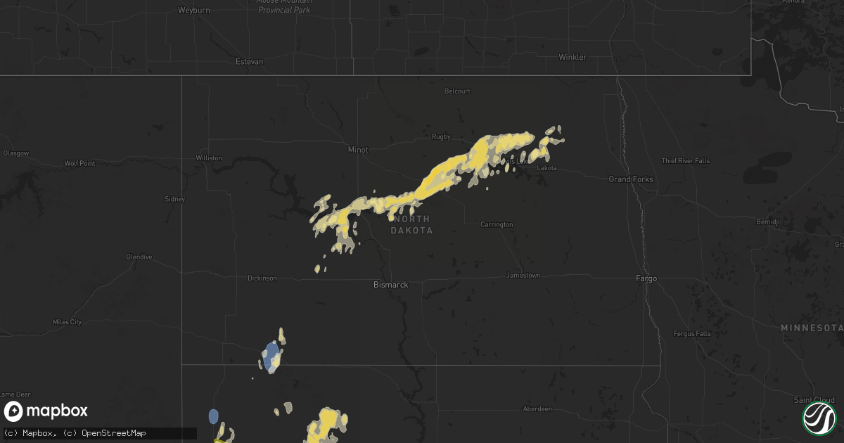
Hail Map in North Dakota on September 15, 2024
Get this storm
September 15 map
$229
one time, instant access
Download today. No call, no setup
Keep the $229
Bought the map and want the full workflow? Apply the entire $229 to a subscription within 7 days. None of it is wasted.
Every map, not just this one
This buys you this map. Subscription and you get every map we run, in the markets you choose from a few cities to whole states to nationwide. Plus real-time alerts the moment a storm fires.
Contact data
Name, contact info, occupancy, even credit band for addresses in the footprint. You go from where it hit to who to call.
Become the source they trust
Unlimited branding weather history reports on demand. You already have the documented answer ready for the property owner, and you are the one who showed up with it.
Property data and RoofTrace estimates
Pull up any address you have got, its value and the exact code rules for that jurisdiction, straight from One Click Code. Then RoofTrace estimates the squares, pitch, and roof value, priced the way you price.
Storm reports in North Dakota
North Dakota
| Date | Description |
|---|---|
| 09/15/20245:15 AM CDT | Delayed report. Large trees reported down in town. |
| 09/15/20243:30 AM CDT | Hail fell for about 5 minutes beginning around 3:30 am cdt... With the largest estimated to be around the size of quarters. Relayed via social media. |
| 09/15/20242:30 AM CDT | Asos station khei hettinger airport. |
| 09/15/20241:58 AM CDT | Public reported hail... Some estimated to be up to the size of golf balls... For about 30 minutes from a period of around 1:45 to 2:15 am cdt. Time estimated by radar w |
| 09/15/20241:30 AM CDT | A local report indicates 1.25 inch wind near 4 SW Pick City |
| 09/15/20241:30 AM CDT | Report via social media. |
All States Impacted by Hail Map on September 15, 2024
Cities Impacted by Hail Map on September 15, 2024
- Galva, KS
- Mcpherson, KS
- Moundridge, KS
- McGregor, TX
- Kosse, TX
- Groesbeck, TX
- Franklin, TX
- Idalia, CO
- Keenesburg, CO
- Thornton, TX
- Trementina, NM
- Wray, CO
- Chugwater, WY
- Cheyenne Wells, CO
- Saint Francis, KS
- Kersey, CO
- La Salle, CO
- Edgemont, SD
- Kit Carson, CO
- Jewett, TX
- Wheatland, WY
- Madisonville, TX
- Benkelman, NE
- Sentinel, OK
- Max, NE
- Iola, TX
- Yoder, WY
- Wauneta, NE
- Palisade, NE
- Lone Wolf, OK
- Hawk Springs, WY
- Eads, CO
- Lamar, CO
- Holly, CO
- Lander, WY
- Riverton, WY
- Hudson, WY
- Arapahoe, WY
- Stratton, NE
- Veteran, WY
- Hobart, OK
- Torrington, WY
- Lingle, WY
- Huntsville, TX
- Wendover, UT
- West Valley City, UT
- Salt Lake City, UT
- Magna, UT
- North Salt Lake, UT
- Bountiful, UT
- Wellington, TX
- Lagrange, WY
- Childress, TX
- Sheridan Lake, CO
- Fort Laramie, WY
- Seymour, TX
- Jay Em, WY
- Morrill, NE
- Maywood, NE
- Harrison, NE
- Mitchell, NE
- Wellfleet, NE
- Curtis, NE
- Maxwell, NE
- Alliance, NE
- Newcastle, WY
- Hayes Center, NE
- Upton, WY
- Moorefield, NE
- Hemingford, NE
- Lance Creek, WY
- Tribune, KS
- Custer, SD
- Belle Fourche, SD
- Newell, SD
- Oelrichs, SD
- Hot Springs, SD
- Hermosa, SD
- Keystone, SD
- Fairburn, SD
- Pringle, SD
- Oral, SD
- Buffalo Gap, SD
- Rapid City, SD
- Caputa, SD
- Carey, ID
- Arco, ID
- Colby, KS
- Monument, KS
- Box Elder, SD
- Ellsworth Afb, SD
- Piedmont, SD
- New Underwood, SD
- Sturgis, SD
- Scott City, KS
- Oakley, KS
- Hulett, WY
- Grinnell, KS
- Rexford, KS
- Hoxie, KS
- Sundance, WY
- Aladdin, WY
- Union Center, SD
- Buffalo, SD
- Gove, KS
- Enning, SD
- Howes, SD
- Stanton, ND
- Beulah, ND
- Zap, ND
- Hazen, ND
- Grainfield, KS
- Turtle Lake, ND
- Mercer, ND
- Faith, SD
- Mud Butte, SD
- Mcclusky, ND
- Coleharbor, ND
- Dupree, SD
- Hettinger, ND
- Park, KS
- Bison, SD
- Quinter, KS
- Meadow, SD
- Drake, ND
- Denhoff, ND
- Butte, ND
- Anamoose, ND
- Ruso, ND
- Golden Valley, ND
- Benedict, ND
- Collyer, KS
- Mott, ND
- Lodgepole, SD
- Garrison, ND
- Lemmon, SD
- Max, ND
- McIntosh, SD
- Isabel, SD
- Martin, ND
- Hill City, KS
- Kadoka, SD
- Interior, SD
- Philip, SD
- Roseglen, ND
- Rugby, ND
- Harvey, ND
- Ryder, ND
- Center, ND
- Glen Ullin, ND
- Hebron, ND
- Esmond, ND
- Kirwin, KS
- Gaylord, KS
- Cedar, KS
- Osborne, KS
- Lebanon, KS
- Greeley, NE
- New Salem, ND
- Spalding, NE
- Underwood, ND
- Portis, KS
- Downs, KS
- Bartlett, NE
- Ericson, NE
- Maddock, ND
- Glen Elder, KS
- Washburn, ND
- Wolbach, NE
- Bogue, KS
- Ewing, NE
- Oneill, NE
- Leeds, ND
- Lenora, KS
- Cawker City, KS
- Minnewaukan, ND
- Inman, NE
- Burke, SD
- Lincoln, KS
- Bladen, NE
- Blue Hill, NE
- Beloit, KS
- Spencer, NE
- Fairfax, SD
- Oberon, ND
- Wagner, SD
- Platte, SD
- Primrose, NE
- Devils Lake, ND
- Lynch, NE
- Churchs Ferry, ND
- Kensington, KS
- Sylvan Grove, KS
- Penn, ND
- Cando, ND
- Starkweather, ND
- Webster, ND
- Bristow, NE
- Smith Center, KS
- Saint Paul, NE
- Tipton, KS
- Saint Michael, ND
- Palmer, NE
- Letcher, SD
- Grand Island, NE
- Edmore, ND
- Crary, ND
- Bonesteel, SD
- Saint Libory, NE
- Lawton, ND
- North Platte, NE
- Scotia, NE
- Royal, NE
- Brocket, ND
- Fairdale, ND
- Esbon, KS
- Chapman, NE
- Lakota, ND
- Barnard, KS
- Adams, ND
- Sheyenne, ND
- Newport, NC
- Swansboro, NC


