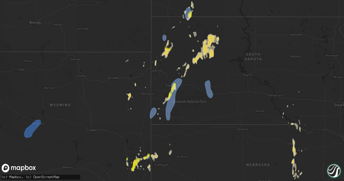
Hail Map on September 15, 2024
Get this storm
September 15 map
$229
one time, instant access
Download today. No call, no setup
Keep the $229
Bought the map and want the full workflow? Apply the entire $229 to a subscription within 7 days. None of it is wasted.
Every map, not just this one
This buys you this map. Subscription and you get every map we run, in the markets you choose from a few cities to whole states to nationwide. Plus real-time alerts the moment a storm fires.
Contact data
Name, contact info, occupancy, even credit band for addresses in the footprint. You go from where it hit to who to call.
Become the source they trust
Unlimited branding weather history reports on demand. You already have the documented answer ready for the property owner, and you are the one who showed up with it.
Property data and RoofTrace estimates
Pull up any address you have got, its value and the exact code rules for that jurisdiction, straight from One Click Code. Then RoofTrace estimates the squares, pitch, and roof value, priced the way you price.
States Impacted by Hail Map on September 15, 2024
Storm reports
New Mexico
| Date | Description |
|---|---|
| 09/15/20244:05 PM CDT | Asos station krtn raton crews airport; in-cloud flashes still present with decaying tstm. |
Texas
| Date | Description |
|---|---|
| 09/14/20247:07 PM CDT | Seymour mesonet. |
North Dakota
| Date | Description |
|---|---|
| 09/15/20245:15 AM CDT | Delayed report. Large trees reported down in town. |
| 09/15/20243:30 AM CDT | Hail fell for about 5 minutes beginning around 3:30 am cdt... With the largest estimated to be around the size of quarters. Relayed via social media. |
| 09/15/20242:30 AM CDT | Asos station khei hettinger airport. |
| 09/15/20241:58 AM CDT | Public reported hail... Some estimated to be up to the size of golf balls... For about 30 minutes from a period of around 1:45 to 2:15 am cdt. Time estimated by radar w |
| 09/15/20241:30 AM CDT | A local report indicates 1.25 inch wind near 4 SW Pick City |
| 09/15/20241:30 AM CDT | Report via social media. |
Arizona
| Date | Description |
|---|---|
| 09/15/20245:45 PM CDT | Multiple trees uprooted in neighborhood. Time estimated based on radar. |
| 09/15/20243:35 PM CDT | Uprooted tree at loves truck stop at interstate 10 and highway 90. Report via social media. |
Utah
| Date | Description |
|---|---|
| 09/15/20246:40 PM CDT | Measured by the udot rwis sensor at the intersection of interstate 80 and interstate 215. |
| 09/15/20246:38 PM CDT | Measured at the salt lake city international airport asos. |
| 09/14/20248:40 PM CDT | Measured at the udot rwis site at us 91 and mp 20 in wellsville. |
| 09/14/20247:00 PM CDT | Measured at the udot rwis sensor on interstate 80 at mp 29. |
Colorado
| Date | Description |
|---|---|
| 09/15/20246:39 PM CDT | Asos station klaa lamar airport. |
| 09/15/20244:40 PM CDT | A local report indicates 1.50 inch wind near 7 S Kersey |
Idaho
| Date | Description |
|---|---|
| 09/15/20246:05 PM CDT | Mesonet station blu blue dome. |
| 09/15/20245:48 PM CDT | Asos station kllj challis airport. |
| 09/14/202410:35 PM CDT | Mesonet station cra craters of the moon. |
| 09/14/202410:35 PM CDT | Mesonet station cra 1 nnw craters of the moon. |
| 09/14/20249:02 PM CDT | Mesonet station crii1 cotton ridge. |
Wyoming
| Date | Description |
|---|---|
| 09/15/20246:48 PM CDT | Report of slightly larger than quarter size hail. |
| 09/15/20246:48 PM CDT | Report of slightly larger that quarter size hail. |
| 09/15/20246:46 PM CDT | Mesonet station shpw4 hudson 3 nnw. |
| 09/15/20246:29 PM CDT | Handheld anemometer recorded 69 mph and 68 mph was measured by anemometer attached to vehicle. |
| 09/15/20246:10 PM CDT | Mesonet station pc259 wyopo. |
| 09/15/20246:00 PM CDT | Asos station klnd lander airport. |
| 09/15/20245:45 PM CDT | Trained spotter reports quarter size hail. |
| 09/14/202410:30 PM CDT | A local report indicates 58 MPH wind near 10 S Upton |
| 09/14/20247:32 PM CDT | Corrects previous hail report from torrington. Social media report of quarter size hail and gusty winds. |
| 09/14/20247:16 PM CDT | Asos station ktor torrington airport - tor. |
South Dakota
| Date | Description |
|---|---|
| 09/15/20244:35 AM CDT | A local report indicates 60 MPH wind near 10 NE Cherry Creek |
| 09/15/20244:31 AM CDT | A local report indicates 59 MPH wind near 9 ENE Belvidere |
| 09/15/20242:20 AM CDT | A local report indicates 65 MPH wind near 2 E Cottonwood |
| 09/15/20242:00 AM CDT | A local report indicates 62 MPH wind near 1 N Buffalo |
| 09/15/20241:58 AM CDT | A local report indicates 60 MPH wind near 4 E Cactus Flat |
| 09/15/20241:30 AM CDT | A local report indicates 61 MPH wind near 1 N Buffalo |
| 09/15/202412:54 AM CDT | A local report indicates 61 MPH wind near 7 WSW Hoover |
| 09/15/202412:36 AM CDT | A local report indicates 59 MPH wind near 12 WSW Castle Rock |
| 09/15/202412:14 AM CDT | A local report indicates 58 MPH wind near 8 N Redig |
| 09/14/202411:35 PM CDT | A local report indicates 62 MPH wind near Ellsworth AFB |
| 09/14/202411:30 PM CDT | Mping report |
| 09/14/202411:25 PM CDT | Copious amounts of hail. |
| 09/14/202411:25 PM CDT | A local report indicates 1.00 inch wind near 4 ENE Dwtn Rapid City |
| 09/14/202411:25 PM CDT | A local report indicates 60 MPH wind near 4 E Dwtn Rapid City |
| 09/14/202411:24 PM CDT | A local report indicates 62 MPH wind near Ellsworth AFB |
| 09/14/202411:24 PM CDT | A local report indicates 61 MPH wind near 2 E Dwtn Rapid City |
| 09/14/202411:24 PM CDT | A local report indicates 1.00 inch wind near 2 E Dwtn Rapid City |
| 09/14/202411:23 PM CDT | A local report indicates 66 MPH wind near 1 E Dwtn Rapid City |
| 09/14/202410:16 PM CDT | A local report indicates 58 MPH wind near 10 S Hot Springs |
| 09/14/20249:38 PM CDT | A local report indicates 61 MPH wind near 10 W Edgemont |
Cities Impacted by Hail Map on September 15, 2024
- Galva, KS
- Mcpherson, KS
- Moundridge, KS
- McGregor, TX
- Kosse, TX
- Groesbeck, TX
- Franklin, TX
- Idalia, CO
- Keenesburg, CO
- Thornton, TX
- Trementina, NM
- Wray, CO
- Chugwater, WY
- Cheyenne Wells, CO
- Saint Francis, KS
- Kersey, CO
- La Salle, CO
- Edgemont, SD
- Kit Carson, CO
- Jewett, TX
- Wheatland, WY
- Madisonville, TX
- Benkelman, NE
- Sentinel, OK
- Max, NE
- Iola, TX
- Yoder, WY
- Wauneta, NE
- Palisade, NE
- Lone Wolf, OK
- Hawk Springs, WY
- Eads, CO
- Lamar, CO
- Holly, CO
- Lander, WY
- Riverton, WY
- Hudson, WY
- Arapahoe, WY
- Stratton, NE
- Veteran, WY
- Hobart, OK
- Torrington, WY
- Lingle, WY
- Huntsville, TX
- Wendover, UT
- West Valley City, UT
- Salt Lake City, UT
- Magna, UT
- North Salt Lake, UT
- Bountiful, UT
- Wellington, TX
- Lagrange, WY
- Childress, TX
- Sheridan Lake, CO
- Fort Laramie, WY
- Seymour, TX
- Jay Em, WY
- Morrill, NE
- Maywood, NE
- Harrison, NE
- Mitchell, NE
- Wellfleet, NE
- Curtis, NE
- Maxwell, NE
- Alliance, NE
- Newcastle, WY
- Hayes Center, NE
- Upton, WY
- Moorefield, NE
- Hemingford, NE
- Lance Creek, WY
- Tribune, KS
- Custer, SD
- Belle Fourche, SD
- Newell, SD
- Oelrichs, SD
- Hot Springs, SD
- Hermosa, SD
- Keystone, SD
- Fairburn, SD
- Pringle, SD
- Oral, SD
- Buffalo Gap, SD
- Rapid City, SD
- Caputa, SD
- Carey, ID
- Arco, ID
- Colby, KS
- Monument, KS
- Box Elder, SD
- Ellsworth Afb, SD
- Piedmont, SD
- New Underwood, SD
- Sturgis, SD
- Scott City, KS
- Oakley, KS
- Hulett, WY
- Grinnell, KS
- Rexford, KS
- Hoxie, KS
- Sundance, WY
- Aladdin, WY
- Union Center, SD
- Buffalo, SD
- Gove, KS
- Enning, SD
- Howes, SD
- Stanton, ND
- Beulah, ND
- Zap, ND
- Hazen, ND
- Grainfield, KS
- Turtle Lake, ND
- Mercer, ND
- Faith, SD
- Mud Butte, SD
- Mcclusky, ND
- Coleharbor, ND
- Dupree, SD
- Hettinger, ND
- Park, KS
- Bison, SD
- Quinter, KS
- Meadow, SD
- Drake, ND
- Denhoff, ND
- Butte, ND
- Anamoose, ND
- Ruso, ND
- Golden Valley, ND
- Benedict, ND
- Collyer, KS
- Mott, ND
- Lodgepole, SD
- Garrison, ND
- Lemmon, SD
- Max, ND
- McIntosh, SD
- Isabel, SD
- Martin, ND
- Hill City, KS
- Kadoka, SD
- Interior, SD
- Philip, SD
- Roseglen, ND
- Rugby, ND
- Harvey, ND
- Ryder, ND
- Center, ND
- Glen Ullin, ND
- Hebron, ND
- Esmond, ND
- Kirwin, KS
- Gaylord, KS
- Cedar, KS
- Osborne, KS
- Lebanon, KS
- Greeley, NE
- New Salem, ND
- Spalding, NE
- Underwood, ND
- Portis, KS
- Downs, KS
- Bartlett, NE
- Ericson, NE
- Maddock, ND
- Glen Elder, KS
- Washburn, ND
- Wolbach, NE
- Bogue, KS
- Ewing, NE
- Oneill, NE
- Leeds, ND
- Lenora, KS
- Cawker City, KS
- Minnewaukan, ND
- Inman, NE
- Burke, SD
- Lincoln, KS
- Bladen, NE
- Blue Hill, NE
- Beloit, KS
- Spencer, NE
- Fairfax, SD
- Oberon, ND
- Wagner, SD
- Platte, SD
- Primrose, NE
- Devils Lake, ND
- Lynch, NE
- Churchs Ferry, ND
- Kensington, KS
- Sylvan Grove, KS
- Penn, ND
- Cando, ND
- Starkweather, ND
- Webster, ND
- Bristow, NE
- Smith Center, KS
- Saint Paul, NE
- Tipton, KS
- Saint Michael, ND
- Palmer, NE
- Letcher, SD
- Grand Island, NE
- Edmore, ND
- Crary, ND
- Bonesteel, SD
- Saint Libory, NE
- Lawton, ND
- North Platte, NE
- Scotia, NE
- Royal, NE
- Brocket, ND
- Fairdale, ND
- Esbon, KS
- Chapman, NE
- Lakota, ND
- Barnard, KS
- Adams, ND
- Sheyenne, ND
- Newport, NC
- Swansboro, NC