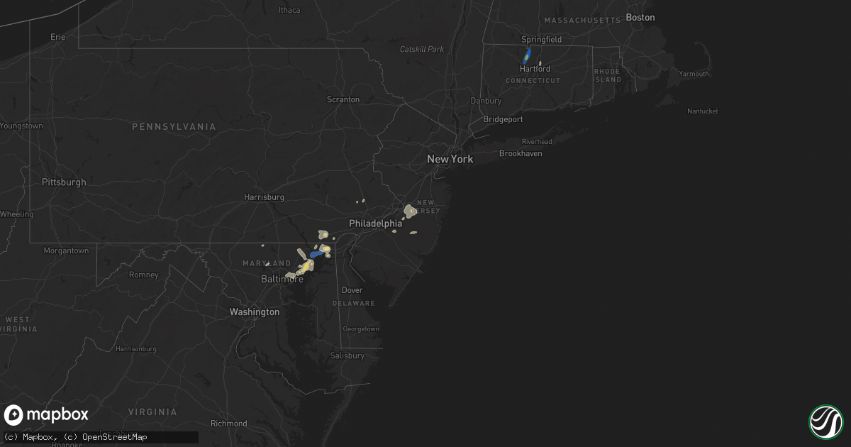
Hail Map in New Jersey on August 2, 2024
Get this storm
August 2 map
$229
one time, instant access
Download today. No call, no setup
Keep the $229
Bought the map and want the full workflow? Apply the entire $229 to a subscription within 7 days. None of it is wasted.
Every map, not just this one
This buys you this map. Subscription and you get every map we run, in the markets you choose from a few cities to whole states to nationwide. Plus real-time alerts the moment a storm fires.
Contact data
Name, contact info, occupancy, even credit band for addresses in the footprint. You go from where it hit to who to call.
Become the source they trust
Unlimited branding weather history reports on demand. You already have the documented answer ready for the property owner, and you are the one who showed up with it.
Property data and RoofTrace estimates
Pull up any address you have got, its value and the exact code rules for that jurisdiction, straight from One Click Code. Then RoofTrace estimates the squares, pitch, and roof value, priced the way you price.
Storm reports in New Jersey
New Jersey
| Date | Description |
|---|---|
| 08/02/20245:50 PM CDT | Report of wires down along sooy place road in woodland township... Nj. Time estimated from radar. |
| 08/02/20245:41 PM CDT | Report of trees and wires down around millstone township in monmouth county. Time estimated from radar. |
| 08/02/20245:34 PM CDT | Wires down on route 206 and old indian mills road in tabernacle... Nj. Time estimated from radar. |
| 08/02/20245:32 PM CDT | Trees and wires down around upper freehold... Nj. |
| 08/02/20245:24 PM CDT | Wires down along georgia trail in medford... Nj. Time estimated from radar. |
| 08/02/20245:23 PM CDT | Report of several trees and wires down around medford with a few trees in houses. Probable microburst. Time estimated from radar. |
| 08/02/20245:23 PM CDT | Pictures sent in of widespread tree damage around cherry and cedar streets in medford township. Probable microburst. Time estimated from radar. |
| 08/02/20245:22 PM CDT | Report of trees and wires down around allentown. Time estimated from radar. |
| 08/02/20245:05 PM CDT | Downed trees in evesham township on elmwood road. Time estimated from radar. |
| 08/02/20245:04 PM CDT | Downed wires on farnsworth avenue in bordentown. Time estimated from radar. |
| 08/02/20245:03 PM CDT | Wires down along fountain avenue in burlington township. Time estimated from radar. |
| 08/02/20245:02 PM CDT | Several wires down in the vicinity of the route 70 and route 73 interchange. Time estimated from radar. |
| 08/02/20244:54 PM CDT | Tree blown down into wires. Time estimated from radar. |
| 08/02/20244:50 PM CDT | Njweathernet. |
| 08/02/20244:45 PM CDT | Report of wires down in pennsauken. Time estimated from radar. |
| 08/01/20248:25 PM CDT | Delayed report: several photos sent in from a trained spotter of trees down throughout carneys point. Time estimated from radar. |
All States Impacted by Hail Map on August 2, 2024
Cities Impacted by Hail Map on August 2, 2024
- Gravel Switch, KY
- Burgaw, NC
- Somerset, KY
- Courtenay, ND
- Palmer, KS
- Corbin, KY
- Thomasville, GA
- Brownsboro, AL
- Gurley, AL
- Holt, FL
- Baker, FL
- Owens Cross Roads, AL
- Leland, NC
- Green Mountain, NC
- Wilmington, NC
- Somerville, AL
- Eva, AL
- New Zion, SC
- Hollytree, AL
- Trenton, AL
- Woodville, AL
- Paint Rock, AL
- Scottsboro, AL
- Castle Hayne, NC
- Defuniak Springs, FL
- Laurel Hill, FL
- Flat Rock, AL
- Grant, AL
- New Hope, AL
- Union Grove, AL
- Arab, AL
- Blountsville, AL
- Holly Pond, AL
- Higdon, AL
- Guntersville, AL
- Delco, NC
- Ash, NC
- Savannah, GA
- Maple Hill, NC
- Albertville, AL
- Hilliard, FL
- Horton, AL
- Bennettsville, SC
- Marion, NC
- Nebo, NC
- McColl, SC
- Asheville, NC
- Alexander, NC
- Callahan, FL
- Lyons, GA
- Hardeeville, SC
- Conway, SC
- Cleveland, AL
- Wallace, NC
- Chadbourn, NC
- Whiteville, NC
- Oneonta, AL
- Kingsland, GA
- Kalamazoo, MI
- Clio, SC
- Smoaks, SC
- Blenheim, SC
- Lodge, SC
- Early Branch, SC
- Clinton, NC
- Ehrhardt, SC
- Little Rock, SC
- Dillon, SC
- Artemus, KY
- Flat Lick, KY
- Barbourville, KY
- Lake City, FL
- White Springs, FL
- Lumber Bridge, NC
- Parkton, NC
- Rose Hill, NC
- South Windsor, CT
- Mattawan, MI
- Schoolcraft, MI
- Walker, KY
- Scalf, KY
- Red Springs, NC
- Ruffin, SC
- Attalla, AL
- Gallant, AL
- Steele, AL
- Williams, SC
- Varnville, SC
- Lawton, MI
- Kettle Island, KY
- Stoney Fork, KY
- Pineville, KY
- Arjay, KY
- Rainbow City, AL
- Ashville, AL
- Colquitt, GA
- Islandton, SC
- Rowland, NC
- Maxton, NC
- Pembroke, NC
- Lumberton, NC
- Independence, VA
- Elk Creek, VA
- Russell, MA
- Walterboro, SC
- Ludowici, GA
- Frakes, KY
- Round O, SC
- Cottageville, SC
- Saint Pauls, NC
- Timmonsville, SC
- Shannon, NC
- Gadsden, AL
- Manchester, KY
- Hulen, KY
- Ohatchee, AL
- Peru, IN
- Amboy, IN
- Autryville, NC
- Townsend, GA
- Coldiron, KY
- Beverly, KY
- Helton, KY
- Taylorsville, NC
- Readyville, TN
- Wappingers Falls, NY
- Wellington, AL
- Forest Hill, MD
- Street, MD
- Hampton, SC
- Florence, SC
- Converse, IN
- Jesup, GA
- Waycross, GA
- Woodbury, TN
- Wallins Creek, KY
- Edwardsburg, MI
- Elkhart, IN
- Jonesville, VA
- Darien, GA
- Pleasant Valley, NY
- Poughkeepsie, NY
- Bladenboro, NC
- Homerville, GA
- Amory, MS
- Blackshear, GA
- Greenwood Springs, MS
- Marion, IN
- Oxford, PA
- Cochranville, PA
- Evarts, KY
- Windfall, IN
- Cranks, KY
- Bel Air, MD
- Pennington Gap, VA
- Labelle, FL
- Kingstree, SC
- Lake City, SC
- Cades, SC
- Cheyenne, WY
- Guin, AL
- Collegeville, PA
- Lincoln University, PA
- Salt Point, NY
- Hyde Park, NY
- Washington, NC
- West Grove, PA
- Churchville, MD
- Benson, NC
- Kirkwood, PA
- Norristown, PA
- Lansdale, PA
- Walsenburg, CO
- Glennville, GA
- Pinetown, NC
- Winfield, AL
- Belfry, KY
- Canada, KY
- Concord, VA
- Appomattox, VA
- Vernon Hill, VA
- Nathalie, VA
- Aberdeen, MD
- Sidney, KY
- Kimper, KY
- Pikeville, KY
- Huddy, KY
- Stone, KY
- McAndrews, KY
- Hardy, KY
- Pinsonfork, KY
- West Simsbury, CT
- Avon, CT
- Simsbury, CT
- Weatogue, CT
- Granby, CT
- North Granby, CT
- West Granby, CT
- Alamogordo, NM
- Tularosa, NM
- Phenix, VA
- Brookneal, VA
- Red House, VA
- Aberdeen Proving Ground, MD
- Perryman, MD
- Belcamp, MD
- Abingdon, MD
- Christiana, PA
- La Luz, NM
- Beaverton, AL
- Sulligent, AL
- Landenberg, PA
- Port Deposit, MD
- Colora, MD
- North East, MD
- Elkton, MD
- Quinton, AL
- Rising Sun, MD
- McCarr, KY
- Ransom, KY
- Phelps, KY
- Freeburn, KY
- Matewan, WV
- Majestic, KY
- Grover, CO
- Chugwater, WY
- Marsland, NE
- Claxton, GA
- Reidsville, GA
- Hamilton, AL
- Steens, MS
- Richmond, IN
- Eaton, OH
- Harrison, NE
- Vernon, AL
- Fayette, AL
- Dora, AL
- Millport, AL
- Graysville, AL
- Coffeeville, MS
- Oakland, MS
- West Point, MS
- Gunpowder, MD
- Edgewood, MD
- Havre De Grace, MD
- Perryville, MD
- Creedmoor, NC
- Franklinton, NC
- Collins, GA
- Columbus, MS
- Surrency, GA
- Luray, SC
- Ethelsville, AL
- Baxley, GA
- Coats, NC
- Stopover, KY
- Hawk Springs, WY
- Torrington, WY
- Kennedy, AL
- Maben, MS
- Reform, AL
- Mantee, MS
- Branson, CO
- Deer Trail, CO
- Jay Em, WY
- Tillatoba, MS
- Caledonia, MS
- Bessemer, AL
- Pheba, MS
- Lumber City, GA
- Aberdeen, MS
- Hazlehurst, GA
- Lagrange, WY
- Elon, NC
- Gibsonville, NC
- Burlington, NC
- Mulga, AL
- Daggett, CA
- Cedarbluff, MS
- Crewe, VA
- Eastpoint, FL
- Raton, NM
- Berry, AL
- Northport, AL
- Tuscaloosa, AL
- Bullock, NC
- Wildwood, FL
- Coleman, FL
- Meriden, WY
- Merriman, NE
- Bushnell, NE
- Barstow, CA
- Echola, AL
- Elrod, AL
- Gordo, AL
- Carrollton, AL
- Mathiston, MS
- Brookwood, AL
- Adger, AL
- Cottondale, AL
- Vance, AL
- Harrisburg, NE
- Gordon, NE
- East Hartford, CT
- Florence, CO
- Woodstock, AL
- West Blocton, AL
- Floyd, NM
- Waverly, VA
- Disputanta, VA
- Penrose, CO
- Wetmore, CO
- Elida, NM
- Morrill, NE
- Mitchell, NE
- Starkville, MS
- Spring Grove, VA
- Bayard, NE
- Pueblo, CO
- Gering, NE
- Stony Creek, VA
- Medford, NJ
- Marlton, NJ
- Buhl, AL
- Coker, AL
- Eutaw, AL
- Ralph, AL
- Wrightstown, NJ
- Trenton, NJ
- Columbus, NJ
- Bordentown, NJ
- Joint Base Mdl, NJ
- Jobstown, NJ
- Robbinsville, NJ
- Allentown, NJ
- Chesterfield, NJ
- Baltimore, MD
- Rosedale, MD
- Valentine, NE
- Knoxville, AL
- Mount Holly, NJ
- Briggsdale, CO
- Fort Morgan, CO
- New Raymer, CO
- Snyder, CO
- Log Lane Village, CO
- Brush, CO
- Akron, CO
- Bridgeport, NE
- Essex, MD
- Aliceville, AL
- New Egypt, NJ
- Cookstown, NJ
- Cream Ridge, NJ
- Woodsfield, OH
- Lewisville, OH
- Graysville, OH
- Lower Salem, OH
- Fosters, AL
- Cody, NE
- Sumterville, FL
- Whitman, NE
- Broadwater, NE
- Huntsville, AL
- Boligee, AL
- Laceys Spring, AL
- Glenwood, GA
- Mount Lemmon, AZ
- Otis, CO
- Angora, NE
- Tucson, AZ
- Alamo, GA
- San Manuel, AZ
- Keeling, VA
- Woodrow, CO
- Varney, KY
- Salisbury, NC
- China Grove, NC
- Landis, NC
- Agate, CO
- Caldwell, OH
- Leeds, AL
- Tariffville, CT
- East Granby, CT
- Pemberton, NJ
- Chatsworth, NJ
- Vincentown, NJ
- Brooksville, MS
- Crawford, MS
- Manchester, MD
- Middle River, MD
- Nottingham, MD
- Mosquero, NM
- Joppa, MD
- Glyndon, MD
- Reisterstown, MD
- Browns Mills, NJ
- Marana, AZ
- Westminster, MD
- Conchas Dam, NM
- Lisco, NE
- Tucumcari, NM
- Hyannis, NE
- Ashby, NE
- Venango, NE
- Rhine, GA
- The Villages, FL
- Garner, NC
- Clayton, NC
- Angier, NC
- Wake Forest, NC
- Whitsett, NC
- Troy, AL
- Eufaula, AL
- Lumpkin, GA
- Omaha, GA
- Dallas, TX
- Irving, TX
- Altoona, AL
- Goodridge, MN
- Gonvick, MN


