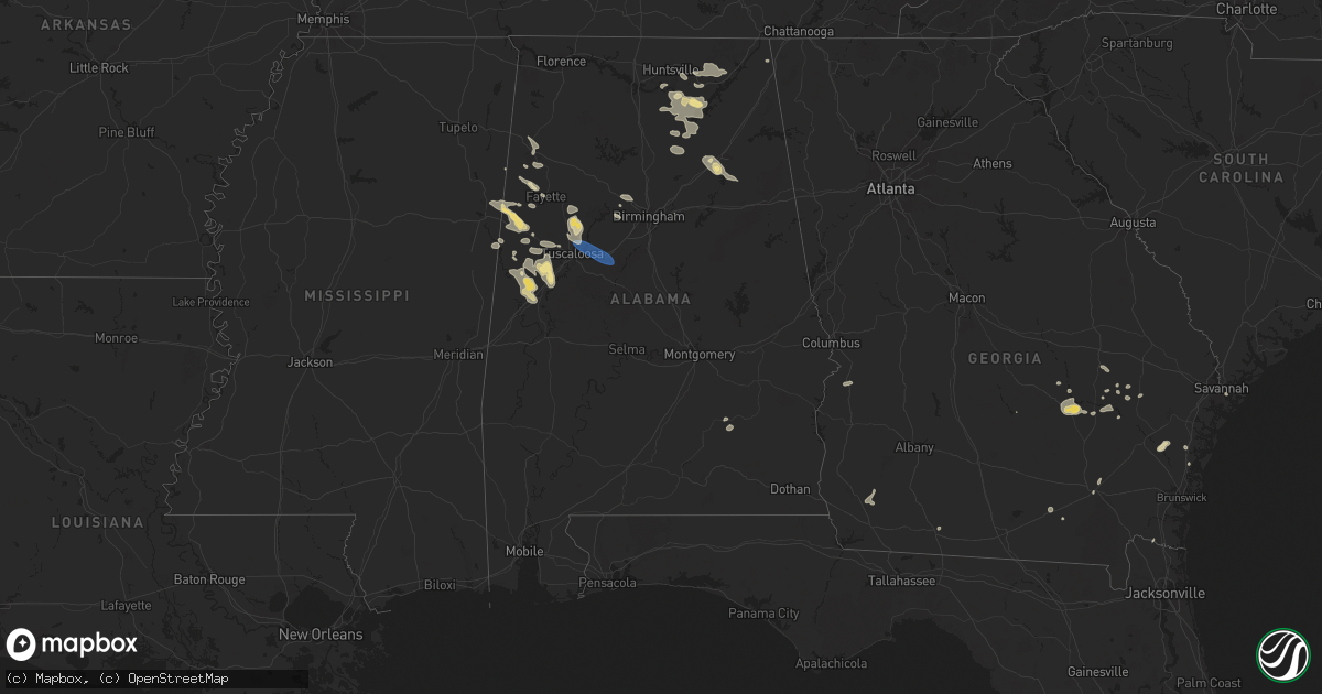
Hail Map in Alabama on August 2, 2024
Get this storm
August 2 map
$229
one time, instant access
Download today. No call, no setup
Keep the $229
Bought the map and want the full workflow? Apply the entire $229 to a subscription within 7 days. None of it is wasted.
Every map, not just this one
This buys you this map. Subscription and you get every map we run, in the markets you choose from a few cities to whole states to nationwide. Plus real-time alerts the moment a storm fires.
Contact data
Name, contact info, occupancy, even credit band for addresses in the footprint. You go from where it hit to who to call.
Become the source they trust
Unlimited branding weather history reports on demand. You already have the documented answer ready for the property owner, and you are the one who showed up with it.
Property data and RoofTrace estimates
Pull up any address you have got, its value and the exact code rules for that jurisdiction, straight from One Click Code. Then RoofTrace estimates the squares, pitch, and roof value, priced the way you price.
Storm reports in Alabama
Alabama
| Date | Description |
|---|---|
| 08/02/20246:19 PM CDT | Trees down in the vance area. |
| 08/02/20246:09 PM CDT | Multiple trees down in the brookwood area. |
| 08/02/20246:09 PM CDT | Tree down along i-20 west affecting lanes of travel. |
| 08/02/20246:03 PM CDT | Trees down on sr 216 in the peterson area. |
| 08/02/20245:53 PM CDT | Trees and some utility lines/transformers down. |
| 08/02/20245:48 PM CDT | Trees down on yellow creek road. |
| 08/02/20245:32 PM CDT | Trees down in various parts of hoover. |
| 08/02/20244:19 PM CDT | Multiple trees down on county road 47 at bethabara road. |
| 08/02/20243:06 PM CDT | Trees down... Some involving blocked roadways... In the talladega area. One residence with a tree on it on christian street. |
| 08/02/20242:44 PM CDT | Multiple trees and power lines down in the oxford area. |
| 08/02/20242:33 PM CDT | Trees down in various spots in northern talladega county... Some involving blocked roadways. |
| 08/02/20242:23 PM CDT | Trees down in the jacksonville area. |
| 08/02/20242:22 PM CDT | Trees and large limbs down in the weaver area. |
| 08/02/20242:20 PM CDT | Trees down in the alexandria area. |
| 08/02/20242:16 PM CDT | Trees down in the ohatchee area. |
| 08/02/20242:01 PM CDT | Multiple areas of trees down in the southside area. At least one motorist reported trapped between trees on hood road. Time estimated from radar. |
| 08/02/20241:54 PM CDT | Several trees down on lister ferry road. |
| 08/02/20241:49 PM CDT | A couple trees blown down on oak grove road and durham drive. Time estimated from radar. |
| 08/02/202412:41 PM CDT | A tree was knocked down... Another uprooted... And a metal roof was blown off of a large barn. This took place at 11113 alabama highway 227. Time estimated by radar. |
| 08/02/202412:23 PM CDT | A social media post/photos indicated a large tree down on power lines in scant city. Time estimated by radar. |
| 08/02/202412:18 PM CDT | Two large trees downed county rd 67 near langston. |
| 08/02/202412:18 PM CDT | Tree downed on hwy 69 at marshall north hospital. |
| 08/02/202412:10 PM CDT | In honeycomb campground... A tree on a camper and camper blown over. |
| 08/02/202412:05 PM CDT | Corrects previous tstm wnd dmg report from 5 ssw grant. Poles and lines in the lake. Also some homes damaged; near hwy 431 and snug harbor rd. Time est from radar. |
| 08/02/202412:05 PM CDT | Poles and lines in the lake. Time est from radar. |
| 08/02/202412:05 PM CDT | Hwy 231 and mountain view road... Report of a tree downed. Est time from radar. |
| 08/02/202412:04 PM CDT | Corrects previous tstm wnd dmg report from 5 se new hope. Up to 14 trees were snapped or uprooted on forty road near grant. Time estimated by radar. |
| 08/02/202411:55 AM CDT | Hwy 35 in the larkinsville/limerock area... Several trees downed. |
| 08/02/202411:55 AM CDT | Hwy 35 in the l |
| 08/02/202411:53 AM CDT | Up to 14 trees were snapped or uprooted on forty road near grant. Time estimated by radar. |
| 08/02/202411:45 AM CDT | County road 114 at county road 121... Tree downed blocking the road. Time est by radar. |
| 08/02/202411:45 AM CDT | Tree reported on power line near mm17 of hwy 67. Time est from radar. |
| 08/02/202411:43 AM CDT | A social media post indicated wind damage at paint rock valley. This included a snapped power pole... Trees uprooted... Metal roofing peeled up and heavy damage to a me |
| 08/02/202411:35 AM CDT | Tree down hwy 65 just across rr crossing near hwy 72. |
| 08/01/20247:30 PM CDT | Reports of tree limbs and power lines down in moundville. |
All States Impacted by Hail Map on August 2, 2024
Cities Impacted by Hail Map on August 2, 2024
- Gravel Switch, KY
- Burgaw, NC
- Somerset, KY
- Courtenay, ND
- Palmer, KS
- Corbin, KY
- Thomasville, GA
- Brownsboro, AL
- Gurley, AL
- Holt, FL
- Baker, FL
- Owens Cross Roads, AL
- Leland, NC
- Green Mountain, NC
- Wilmington, NC
- Somerville, AL
- Eva, AL
- New Zion, SC
- Hollytree, AL
- Trenton, AL
- Woodville, AL
- Paint Rock, AL
- Scottsboro, AL
- Castle Hayne, NC
- Defuniak Springs, FL
- Laurel Hill, FL
- Flat Rock, AL
- Grant, AL
- New Hope, AL
- Union Grove, AL
- Arab, AL
- Blountsville, AL
- Holly Pond, AL
- Higdon, AL
- Guntersville, AL
- Delco, NC
- Ash, NC
- Savannah, GA
- Maple Hill, NC
- Albertville, AL
- Hilliard, FL
- Horton, AL
- Bennettsville, SC
- Marion, NC
- Nebo, NC
- McColl, SC
- Asheville, NC
- Alexander, NC
- Callahan, FL
- Lyons, GA
- Hardeeville, SC
- Conway, SC
- Cleveland, AL
- Wallace, NC
- Chadbourn, NC
- Whiteville, NC
- Oneonta, AL
- Kingsland, GA
- Kalamazoo, MI
- Clio, SC
- Smoaks, SC
- Blenheim, SC
- Lodge, SC
- Early Branch, SC
- Clinton, NC
- Ehrhardt, SC
- Little Rock, SC
- Dillon, SC
- Artemus, KY
- Flat Lick, KY
- Barbourville, KY
- Lake City, FL
- White Springs, FL
- Lumber Bridge, NC
- Parkton, NC
- Rose Hill, NC
- South Windsor, CT
- Mattawan, MI
- Schoolcraft, MI
- Walker, KY
- Scalf, KY
- Red Springs, NC
- Ruffin, SC
- Attalla, AL
- Gallant, AL
- Steele, AL
- Williams, SC
- Varnville, SC
- Lawton, MI
- Kettle Island, KY
- Stoney Fork, KY
- Pineville, KY
- Arjay, KY
- Rainbow City, AL
- Ashville, AL
- Colquitt, GA
- Islandton, SC
- Rowland, NC
- Maxton, NC
- Pembroke, NC
- Lumberton, NC
- Independence, VA
- Elk Creek, VA
- Russell, MA
- Walterboro, SC
- Ludowici, GA
- Frakes, KY
- Round O, SC
- Cottageville, SC
- Saint Pauls, NC
- Timmonsville, SC
- Shannon, NC
- Gadsden, AL
- Manchester, KY
- Hulen, KY
- Ohatchee, AL
- Peru, IN
- Amboy, IN
- Autryville, NC
- Townsend, GA
- Coldiron, KY
- Beverly, KY
- Helton, KY
- Taylorsville, NC
- Readyville, TN
- Wappingers Falls, NY
- Wellington, AL
- Forest Hill, MD
- Street, MD
- Hampton, SC
- Florence, SC
- Converse, IN
- Jesup, GA
- Waycross, GA
- Woodbury, TN
- Wallins Creek, KY
- Edwardsburg, MI
- Elkhart, IN
- Jonesville, VA
- Darien, GA
- Pleasant Valley, NY
- Poughkeepsie, NY
- Bladenboro, NC
- Homerville, GA
- Amory, MS
- Blackshear, GA
- Greenwood Springs, MS
- Marion, IN
- Oxford, PA
- Cochranville, PA
- Evarts, KY
- Windfall, IN
- Cranks, KY
- Bel Air, MD
- Pennington Gap, VA
- Labelle, FL
- Kingstree, SC
- Lake City, SC
- Cades, SC
- Cheyenne, WY
- Guin, AL
- Collegeville, PA
- Lincoln University, PA
- Salt Point, NY
- Hyde Park, NY
- Washington, NC
- West Grove, PA
- Churchville, MD
- Benson, NC
- Kirkwood, PA
- Norristown, PA
- Lansdale, PA
- Walsenburg, CO
- Glennville, GA
- Pinetown, NC
- Winfield, AL
- Belfry, KY
- Canada, KY
- Concord, VA
- Appomattox, VA
- Vernon Hill, VA
- Nathalie, VA
- Aberdeen, MD
- Sidney, KY
- Kimper, KY
- Pikeville, KY
- Huddy, KY
- Stone, KY
- McAndrews, KY
- Hardy, KY
- Pinsonfork, KY
- West Simsbury, CT
- Avon, CT
- Simsbury, CT
- Weatogue, CT
- Granby, CT
- North Granby, CT
- West Granby, CT
- Alamogordo, NM
- Tularosa, NM
- Phenix, VA
- Brookneal, VA
- Red House, VA
- Aberdeen Proving Ground, MD
- Perryman, MD
- Belcamp, MD
- Abingdon, MD
- Christiana, PA
- La Luz, NM
- Beaverton, AL
- Sulligent, AL
- Landenberg, PA
- Port Deposit, MD
- Colora, MD
- North East, MD
- Elkton, MD
- Quinton, AL
- Rising Sun, MD
- McCarr, KY
- Ransom, KY
- Phelps, KY
- Freeburn, KY
- Matewan, WV
- Majestic, KY
- Grover, CO
- Chugwater, WY
- Marsland, NE
- Claxton, GA
- Reidsville, GA
- Hamilton, AL
- Steens, MS
- Richmond, IN
- Eaton, OH
- Harrison, NE
- Vernon, AL
- Fayette, AL
- Dora, AL
- Millport, AL
- Graysville, AL
- Coffeeville, MS
- Oakland, MS
- West Point, MS
- Gunpowder, MD
- Edgewood, MD
- Havre De Grace, MD
- Perryville, MD
- Creedmoor, NC
- Franklinton, NC
- Collins, GA
- Columbus, MS
- Surrency, GA
- Luray, SC
- Ethelsville, AL
- Baxley, GA
- Coats, NC
- Stopover, KY
- Hawk Springs, WY
- Torrington, WY
- Kennedy, AL
- Maben, MS
- Reform, AL
- Mantee, MS
- Branson, CO
- Deer Trail, CO
- Jay Em, WY
- Tillatoba, MS
- Caledonia, MS
- Bessemer, AL
- Pheba, MS
- Lumber City, GA
- Aberdeen, MS
- Hazlehurst, GA
- Lagrange, WY
- Elon, NC
- Gibsonville, NC
- Burlington, NC
- Mulga, AL
- Daggett, CA
- Cedarbluff, MS
- Crewe, VA
- Eastpoint, FL
- Raton, NM
- Berry, AL
- Northport, AL
- Tuscaloosa, AL
- Bullock, NC
- Wildwood, FL
- Coleman, FL
- Meriden, WY
- Merriman, NE
- Bushnell, NE
- Barstow, CA
- Echola, AL
- Elrod, AL
- Gordo, AL
- Carrollton, AL
- Mathiston, MS
- Brookwood, AL
- Adger, AL
- Cottondale, AL
- Vance, AL
- Harrisburg, NE
- Gordon, NE
- East Hartford, CT
- Florence, CO
- Woodstock, AL
- West Blocton, AL
- Floyd, NM
- Waverly, VA
- Disputanta, VA
- Penrose, CO
- Wetmore, CO
- Elida, NM
- Morrill, NE
- Mitchell, NE
- Starkville, MS
- Spring Grove, VA
- Bayard, NE
- Pueblo, CO
- Gering, NE
- Stony Creek, VA
- Medford, NJ
- Marlton, NJ
- Buhl, AL
- Coker, AL
- Eutaw, AL
- Ralph, AL
- Wrightstown, NJ
- Trenton, NJ
- Columbus, NJ
- Bordentown, NJ
- Joint Base Mdl, NJ
- Jobstown, NJ
- Robbinsville, NJ
- Allentown, NJ
- Chesterfield, NJ
- Baltimore, MD
- Rosedale, MD
- Valentine, NE
- Knoxville, AL
- Mount Holly, NJ
- Briggsdale, CO
- Fort Morgan, CO
- New Raymer, CO
- Snyder, CO
- Log Lane Village, CO
- Brush, CO
- Akron, CO
- Bridgeport, NE
- Essex, MD
- Aliceville, AL
- New Egypt, NJ
- Cookstown, NJ
- Cream Ridge, NJ
- Woodsfield, OH
- Lewisville, OH
- Graysville, OH
- Lower Salem, OH
- Fosters, AL
- Cody, NE
- Sumterville, FL
- Whitman, NE
- Broadwater, NE
- Huntsville, AL
- Boligee, AL
- Laceys Spring, AL
- Glenwood, GA
- Mount Lemmon, AZ
- Otis, CO
- Angora, NE
- Tucson, AZ
- Alamo, GA
- San Manuel, AZ
- Keeling, VA
- Woodrow, CO
- Varney, KY
- Salisbury, NC
- China Grove, NC
- Landis, NC
- Agate, CO
- Caldwell, OH
- Leeds, AL
- Tariffville, CT
- East Granby, CT
- Pemberton, NJ
- Chatsworth, NJ
- Vincentown, NJ
- Brooksville, MS
- Crawford, MS
- Manchester, MD
- Middle River, MD
- Nottingham, MD
- Mosquero, NM
- Joppa, MD
- Glyndon, MD
- Reisterstown, MD
- Browns Mills, NJ
- Marana, AZ
- Westminster, MD
- Conchas Dam, NM
- Lisco, NE
- Tucumcari, NM
- Hyannis, NE
- Ashby, NE
- Venango, NE
- Rhine, GA
- The Villages, FL
- Garner, NC
- Clayton, NC
- Angier, NC
- Wake Forest, NC
- Whitsett, NC
- Troy, AL
- Eufaula, AL
- Lumpkin, GA
- Omaha, GA
- Dallas, TX
- Irving, TX
- Altoona, AL
- Goodridge, MN
- Gonvick, MN


