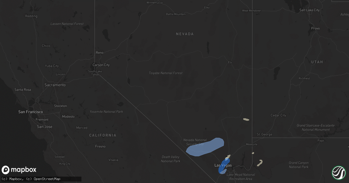
Hail Map in Nevada on July 25, 2021
Get this storm
July 25 map
$229
one time, instant access
Download today. No call, no setup
Keep the $229
Bought the map and want the full workflow? Apply the entire $229 to a subscription within 7 days. None of it is wasted.
Every map, not just this one
This buys you this map. Subscription and you get every map we run, in the markets you choose from a few cities to whole states to nationwide. Plus real-time alerts the moment a storm fires.
Contact data
Name, contact info, occupancy, even credit band for addresses in the footprint. You go from where it hit to who to call.
Become the source they trust
Unlimited branding weather history reports on demand. You already have the documented answer ready for the property owner, and you are the one who showed up with it.
Property data and RoofTrace estimates
Pull up any address you have got, its value and the exact code rules for that jurisdiction, straight from One Click Code. Then RoofTrace estimates the squares, pitch, and roof value, priced the way you price.
Storm reports in Nevada
Nevada
| Date | Description |
|---|---|
| 07/25/20211:06 AM CDT | At 605 PM PDT, a severe thunderstorm was located 7 miles northwest of Caliente, and is moving slowly southwest. HAZARD...60 mph wind gusts and quarter size hail. SOURCE...Radar indicated. IMPACT...Hail damage to vehicles is expected. Expect wind damage to roofs and trees. Locations impacted include... Caliente. |
| 07/25/20211:01 AM CDT | At 559 PM PDT/559 PM MST/, severe thunderstorms were located along a line extending from 16 miles southeast of Grand Canyon Ranch to 13 miles northeast of Packsaddle Campground to near Hualapai Mountain Park, moving west at 25 mph. HAZARD...40 to 60 mph wind gusts. SOURCE...Radar indicated. IMPACT...This storm will produce sudden wind gusts over the Colorado River from Laughlin to Willow Beach which could exceed 40 mph. Possible damage to roofs and trees as well. Locations impacted include... Bullhead City, Laughlin, Katherine Landing, Searchlight, Cottonwood Cove, Cottonwood Cove Campground, Big Bend Rec Area, Cal-Nev-Ari, Dolan Springs and Golden Valley. |
| 07/25/202112:23 AM CDT | Corrects previous tstm wnd gst report from 2 sw pahrump. Report source has been corrected to mesonet. Wind measured at pahrump valley high school. Data courtesy of eart |
| 07/25/202112:06 AM CDT | At 505 PM MST, severe thunderstorms were located along a line extending from 18 miles west of Diamond Creek Campground to 13 miles east of Blake Ranch Road, moving west at 30 mph. HAZARD...60 mph wind gusts. SOURCE...Radar indicated. IMPACT...Expect damage to roofs and trees. Locations impacted include... Bullhead City, Kingman, Laughlin, Katherine Landing, Windy Point Campground, Oatman, Mojave Ranch Estates, Mohave Valley, Blake Ranch Road, Golden Valley, Mesquite Creek, Dw Ranch Road, Packsaddle Campground, Chloride, New Kingman-Butler, Dolan Springs, Hualapai Mountain Park, Wild Cow Campground, Willow Valley and Hualapai Peak.This includes Interstate 40 in Arizona between mile markers 36 and71. |
| 07/24/202111:58 PM CDT | Nvenergy reports over 14000 customers are without power across the las vegas valley due to thunderstorm winds. |
| 07/24/202111:32 PM CDT | Wind gust of 60 mph was reported at sandy valley school. Data courtesy of earth networks. |
| 07/24/202111:32 PM CDT | Wind gust of 68 mph reported at desert rock airport. |
| 07/24/202111:30 PM CDT | Thunderstorm wind damage in pahrump. Roofs blown off multiple structures. Trees 3 to 4 feet in diamter snapped... Car windows broken. Most of the damage is near pershin |
| 07/24/202111:15 PM CDT | Mesquite tree blow down by thunderstorm winds and fell onto a 52 chevy truck. |
| 07/24/202111:15 PM CDT | Thunderstorm wind related damage reported by the public on bruce and lone mountain. Lawn furniture destroyed and security camera blown off of the mount. |
| 07/24/202111:12 PM CDT | Indian springs airport measured a gust of 69 mph at 2114. They also measured a gust of 63 at 2112 due to thunderstorms. |
| 07/24/202111:03 PM CDT | Henderson executive airport gusted to 62 mph at 2103 from thunderstorms. |
| 07/24/202111:03 PM CDT | Wind gust of 62 mph reported at henderson airport. |
| 07/24/202110:38 PM CDT | Power outage reported in east las vegas due to thunderstorm related wind gusts via social media. |
| 07/24/202110:27 PM CDT | North las vegas airport reported a gust of 68 mph at 2027 from a thunderstorm. |
| 07/24/202110:23 PM CDT | Gust of 64 measured from a thunderstorm in north las vegas. Data courtesy of earth networks. |
| 07/24/202110:10 PM CDT | Wind gust of 61 mph reported at union pacific railroad mesowest sensor in dike nevada. |
| 07/24/20218:57 PM CDT | Nvenergy reports 205 customers without power due to thunderstorm winds. |
All States Impacted by Hail Map on July 25, 2021
Cities Impacted by Hail Map on July 25, 2021
- Wanblee, SD
- Ashton, SD
- Corona, NM
- Sheridan Lake, CO
- Eads, CO
- Groom, TX
- Pampa, TX
- Cordell, OK
- Leedey, OK
- Seneca, SD
- Campbell, MN
- Fairmount, ND
- Nashua, MN
- Wendell, MN
- Las Animas, CO
- Littlefield, AZ
- Holly, CO
- Lamar, CO
- Syracuse, KS
- Enterprise, UT
- Saint George, UT
- Moline, KS
- Clarendon, TX
- Mclean, TX
- Miami, TX
- Limon, CO
- Cedar City, UT
- Mullinville, KS
- Hettinger, ND
- Ulysses, KS
- Highmore, SD
- Miller, SD
- Tulare, SD
- Ortonville, MN
- Okeene, OK
- Fairview, OK
- Foss, OK
- Burlington, CO
- Bethune, CO
- Levelland, TX
- Claire City, SD
- Veblen, SD
- Enderlin, ND
- Nome, ND
- Kathryn, ND
- New Effington, SD
- Altus, OK
- Leonard, ND
- Walcott, ND
- Frohna, MO
- Uniontown, MO
- Perryville, MO
- Sheldon, ND
- Tell, TX
- Childress, TX
- Stratton, CO
- Vona, CO
- Mayfield, KS
- Wellington, KS
- Panhandle, TX
- Amarillo, TX
- Litchville, ND
- Fort Ransom, ND
- Wood, SD
- White River, SD
- Okarche, OK
- Blunt, SD
- Fort Pierre, SD
- Pierre, SD
- Harrold, SD
- Ames, OK
- Happy, TX
- Tulia, TX
- Lisbon, ND
- Kit Carson, CO
- Haswell, CO
- Flomot, TX
- Caliente, NV
- Bucklin, KS
- Dodge City, KS
- Jetmore, KS
- Ford, KS
- Wright, KS
- Spearville, KS
- Wyndmere, ND
- Barney, ND
- Selfridge, ND
- Isabella, OK
- Aline, OK
- Waynoka, OK
- Cleo Springs, OK
- Eldorado, OK
- Arapaho, OK
- Clinton, OK
- Canadian, TX
- Floydada, TX
- Custer City, OK
- Rosholt, SD
- Raymond, SD
- Wallace, SD
- Bradley, SD
- Watertown, SD
- Florence, SD
- Clark, SD
- Conde, SD
- Midland, TX
- Arriba, CO
- Martin, SD
- Roaring Springs, TX
- Presho, SD
- Littlefield, TX
- Lockney, TX
- Plainview, TX
- Matador, TX
- Dimmitt, TX
- Muleshoe, TX
- Redfield, SD
- Cuba, KS
- Agenda, KS
- Munden, KS
- Belleville, KS
- Benton, KY
- Gilbertsville, KY
- Mooreton, ND
- Mantador, ND
- Colfax, ND
- Dumont, MN
- Rockham, SD
- Cheyenne Wells, CO
- Two Buttes, CO
- Walsh, CO
- Desert Center, CA
- Yuma, CO
- Spivey, KS
- McLaughlin, SD
- Perryton, TX
- Pine Valley, UT
- Amsterdam, MO
- Butler, MO
- Golden Valley, AZ
- Kingman, AZ
- Overton, NV
- Marion, ND
- Kress, TX
- Canute, OK
- Butler, OK
- Elk City, OK
- Seibert, CO
- Flagler, CO
- Oxford, KS
- Haviland, KS
- Corn, OK
- Ralls, TX
- Selden, KS
- Murdo, SD
- Petersburg, TX
- Johnson, KS
- Manter, KS
- Cope, CO
- Beaver, OK
- Turton, SD
- Cayuga, ND
- Wiley, CO
- Drummond, OK
- Claude, TX
- Gardendale, TX
- Turon, KS
- Wahpeton, ND
- Kingman, KS
- Hoxie, KS
- Odessa, MN
- Clinton, MN
- Hasty, CO
- McClave, CO
- Paragonah, UT
- Protection, KS
- Republican City, NE
- Foxhome, MN
- Breckenridge, MN
- Vulcan, MO
- Piedmont, MO
- Ellington, MO
- Andrews, TX
- Long Valley, SD
- Wolsey, SD
- Saint Lawrence, SD
- Wessington, SD
- Claremont, SD
- Groton, SD
- Columbia, SD
- Odessa, TX
- Cambridge, KS
- Abernathy, TX
- Anton, TX
- Silverton, TX
- Orient, SD
- Ree Heights, SD
- Shidler, OK
- Linn, KS
- Washington, KS
- Richfield, KS
- Shamrock, TX
- Lidgerwood, ND
- Faulkton, SD
- Doland, SD
- Garden City, SD
- Greenfield, OK
- Watonga, OK
- Paducah, TX
- Cee Vee, TX
- Joes, CO
- Coldwater, KS
- Carrizozo, NM
- Milnor, ND
- Kingfisher, OK
- Geary, OK
- Hitchcock, OK
- Omega, OK
- Calumet, OK
- Cedar Vale, KS
- Slaton, TX
- Winfield, KS
- Burden, KS
- Wheaton, MN
- Vinita, OK
- Chelsea, OK
- Karval, CO
- Collinsville, OK
- Lahoma, OK
- Pawhuska, OK
- Weatherford, OK
- Argonia, KS
- Sharon, OK
- Mellette, SD
- Marathon, TX
- Bartlesville, OK
- Greensburg, KS
- Coffeyville, KS
- Appleton, MN
- Orangeburg, NY
- Blauvelt, NY
- Valley Cottage, NY
- Tarrytown, NY
- New City, NY
- West Nyack, NY
- Irvington, NY
- Nanuet, NY
- Nyack, NY
- Arnett, OK
- Elmer, OK
- Olustee, OK
- Kennebec, SD
- Lower Brule, SD
- Sayre, OK
- Chokio, MN
- Graceville, MN
- Mountain View, OK
- Satanta, KS
- Stanton, TX
- Booker, TX
- Henry, SD
- Harper, KS
- Shallowater, TX
- Milford, UT
- Hammon, OK
- Beardsley, MN
- Sedan, KS
- Kendall, KS
- Higgins, TX
- Granada, CO
- New Leipzig, ND
- Elgin, ND
- Indian Springs, NV
- Hoffman, MN
- Herman, MN
- Barrett, MN
- Morrowville, KS
- Barnes, KS
- Greenleaf, KS
- Milan, KS
- Kirk, CO
- Sugar City, CO
- Clyde, KS
- Clifton, KS
- Mahaska, KS
- Holabird, SD
- Dumas, TX
- Hankinson, ND
- Adrian, TX
- Tuthill, SD
- Barnsdall, OK
- Big Cabin, OK
- Morris, MN
- Correll, MN
- Alberta, MN
- Sisseton, SD
- Bellingham, MN
- Donnelly, MN
- Madison, MN
- Holloway, MN
- Ashland, KS
- Wilmore, KS
- Skiatook, OK
- Woodrow, CO
- Sunray, TX
- Geuda Springs, KS
- South Haven, KS
- Conway Springs, KS
- Tintah, MN
- Norcross, MN
- Baldwin City, KS
- Lakin, KS
- Mcleod, ND
- Northville, SD
- Monroe, VA
- Delaware, OK
- Hollenberg, KS
- Tulsa, OK
- Anadarko, OK
- Cement, OK
- Madison Heights, VA
- Draper, SD
- Evansville, MN
- Elbow Lake, MN
- Hitchcock, SD
- Memphis, TX
- Wellington, TX
- Headrick, OK
- Tipton, OK
- Cadiz, KY
- South Shore, SD
- Wakpala, SD
- Chillicothe, TX
- Thomas, OK
- Hudson, KS
- St John, KS
- Sylvia, KS
- Sublette, KS
- Tunas, MO
- Macks Creek, MO
- Quanah, TX
- Offerle, KS
- Lamoure, ND
- Paola, KS
- Amoret, MO
- Stafford, KS
- Greenville, UT
- Ruidoso, NM
- Webster, SD
- Lebanon, SD
- Fergus Falls, MN
- Hedley, TX
- Nellis Afb, NV
- North Las Vegas, NV
- Las Vegas, NV
- Sloan, NV
- Henderson, NV
- Amargosa Valley, NV
- Freedom, OK
- Mooreland, OK
- Duke, OK
- Frederick, OK
- Broken Arrow, OK
- Oologah, OK
- Owasso, OK
- Ramona, OK
- Catoosa, OK
- Ochelata, OK
- Claremore, OK
- Sperry, OK
- Vera, OK
- Southard, OK
- Loyal, OK
- Longdale, OK
- Union City, OK
- El Reno, OK
- Dill City, OK
- Bessie, OK


