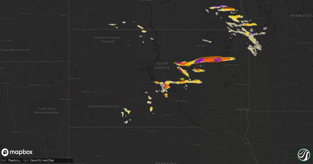
Hail Map on July 25, 2021
Get this storm
July 25 map
$229
one time, instant access
Download today. No call, no setup
Keep the $229
Bought the map and want the full workflow? Apply the entire $229 to a subscription within 7 days. None of it is wasted.
Every map, not just this one
This buys you this map. Subscription and you get every map we run, in the markets you choose from a few cities to whole states to nationwide. Plus real-time alerts the moment a storm fires.
Contact data
Name, contact info, occupancy, even credit band for addresses in the footprint. You go from where it hit to who to call.
Become the source they trust
Unlimited branding weather history reports on demand. You already have the documented answer ready for the property owner, and you are the one who showed up with it.
Property data and RoofTrace estimates
Pull up any address you have got, its value and the exact code rules for that jurisdiction, straight from One Click Code. Then RoofTrace estimates the squares, pitch, and roof value, priced the way you price.
States Impacted by Hail Map on July 25, 2021
Storm reports
Arizona
| Date | Description |
|---|---|
| 07/25/20213:59 AM CDT | At 857 PM PDT/857 PM MST/, severe thunderstorms were located along a line extending from 13 miles north of Cottonwood Cove Campground to Spring Valley to 15 miles north of Indian Springs, moving south at 35 mph. HAZARD...70 mph wind gusts. SOURCE...Radar indicated. IMPACT...Expect considerable tree damage. Damage is likely to mobile homes, roofs, and outbuildings. Locations impacted include... Las Vegas, Henderson, North Las Vegas, Pahrump, Boulder City, Laughlin, Rainbow Canyon, Summerlin, Nellis AFB, Red Rock Canyon, Green Valley, Searchlight, Spring Mountains, Paradise, Lone Mountain, Anthem, Mountains Edge, The Strip, Blue Diamond and Downtown Las Vegas.This includes Interstate 15 in Nevada between mile markers 1 and 25. |
| 07/25/20212:57 AM CDT | At 757 PM PDT/757 PM MST/, severe thunderstorms were located along a line extending from 18 miles north of The Motor Speedway to 7 miles southwest of Echo Bay Campground to Meadview, moving south at 20 mph. HAZARD...60 mph wind gusts. SOURCE...Radar indicated. IMPACT...Expect damage to roofs and trees. Locations impacted include... Las Vegas, Henderson, North Las Vegas, Boulder City, Rainbow Canyon, Summerlin, Nellis AFB, The Motor Speedway, Red Rock Canyon, Green Valley, Spring Mountains, Paradise, Lone Mountain, Anthem, Mountains Edge, The Strip, Blue Diamond, Downtown Las Vegas, East Las Vegas and Sam Boyd Stadium.This includes Interstate 15 in Nevada between mile markers 16 and 76. |
| 07/25/20212:08 AM CDT | At 706 PM PDT/706 PM MST/, a severe thunderstorm was located over Overton Beach, or near Overton, moving west at 35 mph. HAZARD...60 mph wind gusts. SOURCE...Radar indicated. IMPACT...Expect damage to roofs and trees. Locations impacted include... Las Vegas Bay, Overton, Moapa Town, Moapa Valley, Echo Bay, Boulder Beach, Boulder Beach Campground, Las Vegas Bay Campground, Echo Bay Campground, Callville Bay, Meadview, Hoover Dam, Valley Of Fire, Callville Bay Campground, Lake Mead National Recreation Area, Temple Bar Campground, Overton Beach, South Cove, Logandale and Bunkerville.This includes Interstate 15 in Nevada between mile markers 74 and115. |
| 07/24/20219:53 PM CDT | At 252 PM PDT/252 PM MST/, a severe thunderstorm was located 10 miles northwest of South Cove, or 24 miles southeast of Overton, moving southwest at 40 mph. HAZARD...60 mph wind gusts and quarter size hail. SOURCE...Radar indicated. IMPACT...Hail damage to vehicles is expected. Expect wind damage to roofs and trees. Locations impacted include... Las Vegas Bay, Echo Bay, Boulder Beach, Grand Canyon Skywalk, Boulder Beach Campground, Pierce Ferry And Antares Roads, Echo Bay Campground, Callville Bay, Meadview, Hoover Dam, Grand Canyon Ranch, Valley Of Fire, Callville Bay Campground, Lake Mead National Recreation Area, Temple Bar Campground, Dolan Springs, Overton Beach, South Cove, Willow Beach and Temple Bar. |
| 07/24/20219:14 PM CDT | Nevada dot hoover dam sensor at highway 93 measured a gust of 70 mph. |
| 07/24/20219:00 PM CDT | Reports of vessels in distress and numerous boat rescues where boaters had to be retrieved from their vessels and leave their boats behind. |
| 07/24/20218:48 PM CDT | Trained spotter reported a power outage due to severe thunderstorm winds in dolan springs. Happened while we were on the phone with them. Call dropped and they returned |
| 07/24/20217:23 PM CDT | Kingman airport asos reported a gust of 66 mph at 1723. Gusts above 58 mph began at 1657 and ended at 1732. |
Oklahoma
| Date | Description |
|---|---|
| 07/25/20216:20 PM CDT | A local report indicates 70 MPH wind near 3 S ALTUS |
| 07/25/20216:19 PM CDT | Report from mping: 3-inch tree limbs broken; power poles broken. |
| 07/25/20216:15 PM CDT | Nws employee reports 1 inch tree limbs broken and shingles blown off. Time estimated from radar. |
| 07/25/20216:15 PM CDT | A local report indicates 64 MPH wind near 3 S ALTUS |
| 07/25/20216:01 PM CDT | Report from mping: 1-inch tree limbs broken; shingles blown off. |
| 07/25/20216:01 PM CDT | Tul asos measured peak wind gust of 63 mph. |
| 07/25/20216:01 PM CDT | A local report indicates 62 MPH wind near TULSA |
| 07/25/20216:01 PM CDT | Limbs down... Shingles blown off roofs |
| 07/25/20216:00 PM CDT | Picture relayed via social media of 6-12 inch diameter tree branch blown over onto car. |
| 07/25/20215:50 PM CDT | 6-12 inch tree limbs snapped. Picture from social media. Time estimated from radar. |
| 07/25/20215:50 PM CDT | Corrects previous tstm wnd dmg report from 2 sse collinsville. Report from mping: 3-inch tree limbs broken; power poles broken - time estimated form radar. |
| 07/25/20213:40 PM CDT | A local report indicates 69 MPH wind near 3 SSW FREEDOM |
| 07/25/20214:23 AM CDT | At 923 PM CDT, a severe thunderstorm was located near Verden, moving north at 20 mph. HAZARD...60 mph wind gusts and quarter size hail. SOURCE...Radar indicated. IMPACT...Hail damage to vehicles is expected. Expect wind damage to roofs, siding, and trees. Locations impacted include... Verden, Pocasset, Lake Chickasha and Laverty. |
| 07/25/20214:12 AM CDT | At 912 AM CDT, a severe thunderstorm was located 6 miles west of Vici, moving southeast at 5 mph. HAZARD...60 mph wind gusts and quarter size hail. SOURCE...Radar indicated. IMPACT...Hail damage to vehicles is expected. Expect wind damage to roofs, siding, and trees. Locations impacted include... Vici. |
| 07/25/20213:38 AM CDT | At 838 PM CDT, a severe thunderstorm was located near Burns Flat, moving southeast at 20 mph. HAZARD...60 mph wind gusts and quarter size hail. SOURCE...Radar indicated. IMPACT...Hail damage to vehicles is expected. Expect wind damage to roofs, siding, and trees. Locations impacted include... Cordell, Burns Flat, Sentinel, Dill City and Rocky. |
| 07/25/20213:12 AM CDT | At 811 PM CDT, a severe thunderstorm was located near Moorewood, moving north at 25 mph. HAZARD...60 mph wind gusts and quarter size hail. SOURCE...Radar indicated. IMPACT...Hail damage to vehicles is expected. Expect wind damage to roofs, siding, and trees. Locations impacted include... Leedey, Camargo, Angora and Moorewood. |
| 07/25/20212:34 AM CDT | At 733 PM CDT, severe thunderstorms were located along a line extending from 4 miles northeast of Kingfisher to 4 miles northeast of Greenfield to 3 miles southwest of Arapaho to near Canute, moving south at 15 mph. HAZARD...60 mph wind gusts and quarter size hail. SOURCE...Radar indicated. IMPACT...Hail damage to vehicles is expected. Expect wind damage to roofs, siding, and trees. Locations impacted include... Northwestern Oklahoma City, El Reno, Elk City, Weatherford, Clinton, Kingfisher, Cordell, Piedmont, Hinton, Burns Flat, Geary, Okarche, Hydro, Sentinel, Arapaho, Dill City, Canute, Calumet, Corn and Bessie. |
| 07/25/20212:00 AM CDT | At 700 PM CDT, individual severe thunderstorms were located along a broken line extending from near Greenfield to 3 miles south of Thomas to near Butler, moving south at 15 mph. HAZARD...60 mph wind gusts and quarter size hail. SOURCE...Radar indicated. IMPACT...Hail damage to vehicles is expected. Expect wind damage to roofs, siding, and trees. Locations impacted include... Weatherford, Clinton, Watonga, Burns Flat, Geary, Thomas, Hydro, Arapaho, Custer City, Butler, Foss, Bridgeport, Greenfield, Foss Reservoir and Stafford. |
| 07/25/20211:45 AM CDT | At 645 PM CDT, a severe thunderstorm was located near Humphreys, moving east at 10 mph. Additional storms have developed near Tipton. HAZARD...60 mph wind gusts and quarter size hail. SOURCE...Radar indicated. IMPACT...Hail damage to vehicles is expected. Expect wind damage to roofs, siding, and trees. Locations impacted include... Frederick, Tipton, Manitou, Headrick, Humphreys and Hess. |
| 07/25/20211:43 AM CDT | At 643 PM CDT, a severe thunderstorm was located 4 miles northeast of Hitchcock, moving southeast at 20 mph. Additional storms have developed near Kingfisher and Omega. HAZARD...60 mph wind gusts and quarter size hail. SOURCE...Radar indicated. IMPACT...Hail damage to vehicles is expected. Expect wind damage to roofs, siding, and trees. Locations impacted include... Kingfisher, Okeene, Hitchcock, Loyal and Omega. |
| 07/25/202112:54 AM CDT | At 554 PM CDT, a severe thunderstorm was located over Collinsville, moving southeast at 30 mph. HAZARD...60 mph wind gusts. SOURCE...Radar indicated. IMPACT...Expect damage to roofs, siding, and trees. Locations in or near the path include... Tulsa... Broken Arrow... Claremore... Owasso... Skiatook... Catoosa... Collinsville... Verdigris... Inola... Taiwah... Tiawah... This includes Interstate 44 between mile markers 230 and 252. |
| 07/25/202112:53 AM CDT | At 553 PM CDT, a severe thunderstorm was located 5 miles southwest of Orienta, moving southeast at 20 mph. HAZARD...60 mph wind gusts and quarter size hail. SOURCE...Radar indicated. IMPACT...Hail damage to vehicles is expected. Expect wind damage to roofs, siding, and trees. Locations impacted include... Fairview, Okeene, Canton, Longdale, Orienta, eastern Canton Lake, Homestead and Southard. |
| 07/25/202112:35 AM CDT | At 535 PM CDT, a severe thunderstorm was located over Ramona, moving southeast at 25 mph. HAZARD...60 mph wind gusts. SOURCE...Radar indicated. IMPACT...Expect damage to roofs, siding, and trees. Locations in or near the path include... Tulsa... Owasso... Skiatook... Collinsville... Sperry... Oologah... Ramona... Ochelata... Avant... Vera... Turley... |
| 07/25/202112:35 AM CDT | At 534 PM CDT, a severe thunderstorm was located over Drummond, moving southeast at 10 mph. HAZARD...60 mph wind gusts and quarter size hail. SOURCE...Radar indicated. IMPACT...Hail damage to vehicles is expected. Expect wind damage to roofs, siding, and trees. Locations impacted include... Hennessey, Waukomis, Drummond and Bison. |
| 07/25/202112:12 AM CDT | At 512 PM CDT, a severe thunderstorm was located 4 miles northwest of Ochelata, moving southeast at 35 mph. HAZARD...60 mph wind gusts and quarter size hail. SOURCE...Radar indicated. IMPACT...Hail damage to vehicles is expected. Expect wind damage to roofs, siding, and trees. Locations in or near the path include... Bartlesville... Skiatook... Barnsdall... Ramona... Wynona... Ochelata... Avant... Vera... Bartlesville Municipal Airport... Watova... Okesa... Tallant... Pershing... Nelagoney... Wolco... |
| 07/25/202112:08 AM CDT | At 507 PM CDT, a severe thunderstorm was located 6 miles west of Aline, moving south at 15 mph. HAZARD...70 mph wind gusts and ping pong ball size hail. SOURCE...Radar indicated. IMPACT...People and animals outdoors will be injured. Expect hail damage to roofs, siding, windows, and vehicles. Expect considerable tree damage. Wind damage is also likely to mobile homes, roofs, and outbuildings. Locations impacted include... Fairview, Cleo Springs and Orienta. |
| 07/24/202111:55 PM CDT | At 455 PM CDT, a severe thunderstorm was located near Osage Hills State Park, moving southeast at 20 mph. HAZARD...60 mph wind gusts and quarter size hail. SOURCE...Radar indicated. IMPACT...Hail damage to vehicles is expected. Expect wind damage to roofs, siding, and trees. Locations in or near the path include... Bartlesville... Barnsdall... Osage Hills State Park... Okesa... Bartlesville Municipal Airport... Tallant... |
| 07/24/202111:34 PM CDT | At 433 PM CDT, a severe thunderstorm was located 5 miles south of Beaver, moving northeast at 5 mph. HAZARD...60 mph wind gusts and half dollar size hail. SOURCE...Radar indicated. IMPACT...Minor damage to roofs, siding, and trees is possible. Hail damage to vehicles is expected. Locations impacted include... Beaver, Mocane, Elmwood, Balko and Boyd. |
| 07/24/202110:48 PM CDT | At 347 PM CDT, a severe thunderstorm was located 6 miles northwest of Freedom, moving southeast at 30 mph. HAZARD...70 mph wind gusts and nickel size hail. SOURCE...Radar indicated. IMPACT...Expect considerable tree damage. Damage is likely to mobile homes, roofs, and outbuildings. Locations impacted include... Waynoka, Freedom, Alabaster Caverns State Park and Camp Houston. |
| 07/24/20219:36 PM CDT | Outflow boundary. |
| 07/24/20218:45 PM CDT | A local report indicates 59 MPH wind near 4 WNW BESSIE |
| 07/24/20218:35 PM CDT | A local report indicates 60 MPH wind near 4 SW EL RENO |
| 07/24/20218:15 PM CDT | A local report indicates 68 MPH wind near 1 NE ELK CITY |
| 07/24/20217:50 PM CDT | A local report indicates 61 MPH wind near 5 SW BUTLER |
| 07/24/20217:28 PM CDT | A local report indicates 70 MPH wind near 4 NW OKARCHE |
California
| Date | Description |
|---|---|
| 07/25/20216:07 PM CDT | *** delayed report *** downed joshua tree on keys view rd. In jtnp. Time estimated using radar. |
| 07/25/20214:55 AM CDT | At 951 PM PDT, severe thunderstorms were located along a line extending from near Indian Springs to 7 miles west of Sandy Valley to 11 miles north of Nipton Road Mile Marker 3, moving west at 45 mph. HAZARD...70 mph wind gusts. SOURCE...Radar indicated. IMPACT...Expect considerable tree damage. Damage is likely to mobile homes, roofs, and outbuildings. Locations impacted include... Pahrump, Beatty, Jean, Shoshone, Furnace Creek, Primm, Mercury, Spring Mountains, Sandy Valley, Goodsprings, Texas Springs Campground, Indian Springs, Mountain Springs, Mcwilliams Campground, Willow Creek Campground, Death Valley Junction, Amargosa Valley, Mary Jane Falls Campground, Dolomite Campground and Lathrop Wells.This includes the following highways... Interstate 15 in California near mile marker 186. Interstate 15 in Nevada between mile markers 1 and 18. |
| 07/24/202111:14 PM CDT | At 413 PM PDT, a severe thunderstorm was located 14 miles south of Twentynine Palms, and is nearly stationary. HAZARD...60 mph wind gusts and half dollar size hail. SOURCE...Radar indicated. IMPACT...Hail damage to vehicles is expected. Expect wind damage to roofs, siding, and trees. Locations impacted include... Indio, Coachella, Cathedral City, Palm Desert, eastern Desert Hot Springs, Rancho Mirage, La Quinta, Sky Valley, Thousand Palms and Bermuda Dunes. |
| 07/24/202111:01 PM CDT | At 400 PM PDT, a severe thunderstorm was located 14 miles north of Indio, moving west at 15 mph. HAZARD...60 mph wind gusts and half dollar size hail. SOURCE...Radar indicated. IMPACT...Hail damage to vehicles is expected. Expect wind damage to roofs, siding, and trees. Locations impacted include... Key View. |
North Dakota
| Date | Description |
|---|---|
| 07/25/20216:10 AM CDT | At 1110 PM CDT, severe thunderstorms were located along a line extending from near Fort Ransom to near Venlo, moving east at 35 mph. HAZARD...Golf ball size hail and 60 mph wind gusts. SOURCE...Radar indicated. IMPACT...People and animals outdoors will be injured. Expect hail damage to roofs, siding, windows, and vehicles. Expect wind damage to roofs, siding, and trees. Severe thunderstorms will be near... McLeod around 1120 PM CDT.Other locations in the path of these severe thunderstorms includeLisbon, Enderlin, Anselm, Sheldon, Venlo, Colfax and Galchutt.This includes Interstate 29 between mile markers 27 and 47. |
| 07/25/20215:04 AM CDT | At 1004 PM CDT, a severe thunderstorm was located near Wyndmere, or 29 miles west of Wahpeton, moving east at 20 mph. HAZARD...70 mph wind gusts and half dollar size hail. SOURCE...Radar indicated. IMPACT...Hail damage to vehicles is expected. Expect considerable tree damage. Wind damage is also likely to mobile homes, roofs, and outbuildings. This severe thunderstorm will be near... Wyndmere around 1020 PM CDT.Other locations in the path of this severe thunderstorm includeBarney, Mooreton, Dwight and Galchutt.This includes Interstate 29 between mile markers 17 and 32. |
| 07/25/20214:55 AM CDT | At 954 PM CDT, a severe thunderstorm was located over Tenney, or 14 miles southeast of Wahpeton, moving east at 40 mph. HAZARD...70 mph wind gusts and half dollar size hail. SOURCE...Radar indicated. IMPACT...Hail damage to vehicles is expected. Expect considerable tree damage. Wind damage is also likely to mobile homes, roofs, and outbuildings. This severe thunderstorm will be near... Campbell around 1000 PM CDT. Nashua around 1010 PM CDT. |
| 07/24/202111:40 PM CDT | Report and photo posted via social media. Time estimated based on radar. |
| 07/24/202111:30 PM CDT | Sporadic golfball sized hail fell...minimal crop damage. |
| 07/24/202111:30 PM CDT | Sporadic golfball sized hail fell... Minimal crop damage noticed. |
| 07/24/202110:40 PM CDT | Report and photo posted via social media. Time estimated based on radar. |
| 07/24/202110:25 PM CDT | Picture of estimated 1.75 inch hail relayed by broadcast media. Time estimated by radar. |
| 07/24/202110:25 PM CDT | Reports and photos posted via social media. Time estimated based on radar. |
| 07/24/20219:55 PM CDT | Dime to half dollar sized hail. Report and photo posted via social media. |
| 07/24/20219:50 PM CDT | Photo and report posted via social media. Time estimated based on radar. |
Nevada
| Date | Description |
|---|---|
| 07/25/20211:06 AM CDT | At 605 PM PDT, a severe thunderstorm was located 7 miles northwest of Caliente, and is moving slowly southwest. HAZARD...60 mph wind gusts and quarter size hail. SOURCE...Radar indicated. IMPACT...Hail damage to vehicles is expected. Expect wind damage to roofs and trees. Locations impacted include... Caliente. |
| 07/25/20211:01 AM CDT | At 559 PM PDT/559 PM MST/, severe thunderstorms were located along a line extending from 16 miles southeast of Grand Canyon Ranch to 13 miles northeast of Packsaddle Campground to near Hualapai Mountain Park, moving west at 25 mph. HAZARD...40 to 60 mph wind gusts. SOURCE...Radar indicated. IMPACT...This storm will produce sudden wind gusts over the Colorado River from Laughlin to Willow Beach which could exceed 40 mph. Possible damage to roofs and trees as well. Locations impacted include... Bullhead City, Laughlin, Katherine Landing, Searchlight, Cottonwood Cove, Cottonwood Cove Campground, Big Bend Rec Area, Cal-Nev-Ari, Dolan Springs and Golden Valley. |
| 07/25/202112:23 AM CDT | Corrects previous tstm wnd gst report from 2 sw pahrump. Report source has been corrected to mesonet. Wind measured at pahrump valley high school. Data courtesy of eart |
| 07/25/202112:06 AM CDT | At 505 PM MST, severe thunderstorms were located along a line extending from 18 miles west of Diamond Creek Campground to 13 miles east of Blake Ranch Road, moving west at 30 mph. HAZARD...60 mph wind gusts. SOURCE...Radar indicated. IMPACT...Expect damage to roofs and trees. Locations impacted include... Bullhead City, Kingman, Laughlin, Katherine Landing, Windy Point Campground, Oatman, Mojave Ranch Estates, Mohave Valley, Blake Ranch Road, Golden Valley, Mesquite Creek, Dw Ranch Road, Packsaddle Campground, Chloride, New Kingman-Butler, Dolan Springs, Hualapai Mountain Park, Wild Cow Campground, Willow Valley and Hualapai Peak.This includes Interstate 40 in Arizona between mile markers 36 and71. |
| 07/24/202111:58 PM CDT | Nvenergy reports over 14000 customers are without power across the las vegas valley due to thunderstorm winds. |
| 07/24/202111:32 PM CDT | Wind gust of 60 mph was reported at sandy valley school. Data courtesy of earth networks. |
| 07/24/202111:32 PM CDT | Wind gust of 68 mph reported at desert rock airport. |
| 07/24/202111:30 PM CDT | Thunderstorm wind damage in pahrump. Roofs blown off multiple structures. Trees 3 to 4 feet in diamter snapped... Car windows broken. Most of the damage is near pershin |
| 07/24/202111:15 PM CDT | Mesquite tree blow down by thunderstorm winds and fell onto a 52 chevy truck. |
| 07/24/202111:15 PM CDT | Thunderstorm wind related damage reported by the public on bruce and lone mountain. Lawn furniture destroyed and security camera blown off of the mount. |
| 07/24/202111:12 PM CDT | Indian springs airport measured a gust of 69 mph at 2114. They also measured a gust of 63 at 2112 due to thunderstorms. |
| 07/24/202111:03 PM CDT | Henderson executive airport gusted to 62 mph at 2103 from thunderstorms. |
| 07/24/202111:03 PM CDT | Wind gust of 62 mph reported at henderson airport. |
| 07/24/202110:38 PM CDT | Power outage reported in east las vegas due to thunderstorm related wind gusts via social media. |
| 07/24/202110:27 PM CDT | North las vegas airport reported a gust of 68 mph at 2027 from a thunderstorm. |
| 07/24/202110:23 PM CDT | Gust of 64 measured from a thunderstorm in north las vegas. Data courtesy of earth networks. |
| 07/24/202110:10 PM CDT | Wind gust of 61 mph reported at union pacific railroad mesowest sensor in dike nevada. |
| 07/24/20218:57 PM CDT | Nvenergy reports 205 customers without power due to thunderstorm winds. |
New Jersey
| Date | Description |
|---|---|
| 07/25/20215:58 AM CDT | At 1058 PM EDT, a severe thunderstorm was located over Orangeburg, or over Tappan, moving southeast at 30 mph. HAZARD...60 mph wind gusts and quarter size hail. SOURCE...Radar indicated. IMPACT...Minor hail damage to vehicles is possible. Expect wind damage to trees and power lines. This severe thunderstorm will be near... Hawthorne around 1105 PM EDT. Dobbs Ferry around 1110 PM EDT. Yonkers and White Plains around 1115 PM EDT. New Rochelle and Harrison around 1120 PM EDT. Port Chester and Rye around 1125 PM EDT. Throgs Neck Bridge and Sands Point around 1130 PM EDT. Glen Cove and Great Neck around 1135 PM EDT. Manhasset and Bayville around 1140 PM EDT. Mineola and Oyster Bay around 1145 PM EDT. Garden City and Syosset around 1150 PM EDT. Huntington Station and Plainview around 1155 PM EDT. |
New Mexico
| Date | Description |
|---|---|
| 07/25/202112:24 AM CDT | At 523 PM MDT, a severe thunderstorm was located 9 miles northwest of Holloman Air Force Base, moving northwest at 30 mph. HAZARD...70 mph wind gusts. SOURCE...Radar indicated. IMPACT...Expect considerable tree damage. Damage is likely to mobile homes, roofs, and outbuildings. Locations impacted include... Three Rivers, Northrup Landing, Tularosa, White Sands National Monument and Holloman Air Force Base.This includes Highway 54 in New Mexico between mile markers 74 and96. |
| 07/24/20219:49 PM CDT | At 249 PM MDT, a severe thunderstorm was located over Corona, moving north at 10 mph. HAZARD...60 mph wind gusts and half dollar size hail. SOURCE...Radar indicated. IMPACT...Hail damage to vehicles is expected. Expect wind damage to roofs, siding, and trees. Locations impacted include... Corona and Cedarvale. |
| 07/24/20218:57 PM CDT | At 157 PM MDT, a severe thunderstorm was located 7 miles east of White Oaks, or 17 miles east of Carrizozo, moving northeast at 15 mph. HAZARD...60 mph wind gusts and half dollar size hail. SOURCE...Radar indicated. IMPACT...Hail damage to vehicles is expected. Expect wind damage to roofs, siding, and trees. Locations impacted include... Encinoso and White Oaks. |
| 07/24/20218:28 PM CDT | At 128 PM MDT, a severe thunderstorm was located over Bonito Lake, or 9 miles north of Ruidoso, moving northwest at 10 mph. HAZARD...60 mph wind gusts and quarter size hail. SOURCE...Radar indicated. IMPACT...Hail damage to vehicles is expected. Expect wind damage to roofs, siding, and trees. Locations impacted include... Bonito Lake and Nogal. This includes Highway 380 between Mile Markers 68 and 74. |
New York
| Date | Description |
|---|---|
| 07/24/202110:25 PM CDT | Tree down on i-87 southbound between exit 7a and 7. Tree blocking right lane. Time estimated from radar. |
Virginia
| Date | Description |
|---|---|
| 07/25/20215:44 PM CDT | Several trees down along ambrose rucker road. |
| 07/25/20215:26 PM CDT | Several trees down along lexington highway. Time estimated by radar. |
| 07/25/20212:57 AM CDT | At 757 PM EDT, a severe thunderstorm was located near Madison Heights, or near Lynchburg, moving southeast at 10 mph. HAZARD...60 mph wind gusts and quarter size hail. SOURCE...Radar indicated. IMPACT...Hail damage to vehicles is expected. Expect wind damage to roofs, siding, and trees. Locations impacted include... Appomattox... Concord... Rustburg... Madison Heights... Appomattox National Historic Park... Stonewall... and Bocock. |
| 07/25/20211:44 AM CDT | At 644 PM EDT, severe thunderstorms were located along a line extending from near New Glasgow to near Boonsboro, moving southeast at 15 mph. HAZARD...60 mph wind gusts and quarter size hail. SOURCE...Radar indicated. IMPACT...Hail damage to vehicles is expected. Expect wind damage to roofs, siding, and trees. Locations impacted include... Amherst... Bent Creek... Madison Heights... Falconerville... Riverville... New Glasgow... and Stonewall. |
Minnesota
| Date | Description |
|---|---|
| 07/25/20215:26 AM CDT | At 1025 PM CDT, a severe thunderstorm was located near Nashua, or 16 miles southwest of Fergus Falls, moving east at 30 mph. HAZARD...70 mph wind gusts and half dollar size hail. SOURCE...Radar indicated. IMPACT...Hail damage to vehicles is expected. Expect considerable tree damage. Wind damage is also likely to mobile homes, roofs, and outbuildings. This severe thunderstorm will be near... Western around 1035 PM CDT. Wendell around 1040 PM CDT.Other locations in the path of this severe thunderstorm include ElbowLake, Dalton, Ashby and Erdahl.This includes Interstate 94 in Minnesota between mile markers 64 and80. |
| 07/25/20215:04 AM CDT | At 1004 PM CDT, a severe thunderstorm was located near Wheaton, moving east at 35 mph. HAZARD...Quarter size hail. SOURCE...Radar indicated. IMPACT...Damage to vehicles is expected. This severe thunderstorm will remain over mainly rural areas of east central Traverse County. |
| 07/24/202111:05 PM CDT | A local report indicates 1.00 inch wind near WHEATON |
| 07/24/202110:30 PM CDT | Gold ball size hail... Short duration... With shingels damaged. |
| 07/24/202110:30 PM CDT | Golf ball sized hail... Short duration... With shingles damaged. |
| 07/24/202110:10 PM CDT | Reports and photos posted via social media. |
| 07/24/202110:04 PM CDT | Radar estimated time. |
| 07/24/202110:00 PM CDT | A local report indicates 1.00 inch wind near WHEATON |
South Dakota
| Date | Description |
|---|---|
| 07/25/20216:46 PM CDT | A local report indicates 1.00 inch wind near 7 SW FAULKTON |
| 07/25/20216:35 PM CDT | Verified by social media photos. Time estimated. |
| 07/25/20216:32 PM CDT | A local report indicates 1.75 inch wind near 7 W MILLER DALE COLONY |
| 07/25/20216:20 PM CDT | Radar estimated time. |
| 07/25/20215:42 PM CDT | Quarter to golf ball size hail reported on social media with photo. Time estimated. |
| 07/25/20214:38 AM CDT | At 938 PM CDT, a severe thunderstorm was located over Sonora, or 17 miles south of Wahpeton, moving east at 30 mph. HAZARD...60 mph wind gusts and quarter size hail. SOURCE...Radar indicated. IMPACT...Hail damage to vehicles is expected. Expect wind damage to roofs, siding, and trees. This severe thunderstorm will be near... Fairmount and Lamars around 945 PM CDT. Blackmer around 950 PM CDT.This includes Interstate 29 between mile markers 3 and 14. |
| 07/25/20213:54 AM CDT | At 853 PM CDT, a severe thunderstorm was located over Wallace, or 16 miles northeast of Clark, moving east at 35 mph. HAZARD...Half dollar size hail. SOURCE...Radar indicated. IMPACT...Damage to vehicles is expected. This severe thunderstorm will be near... Grass Lake around 900 PM CDT. Florence and Medicine Lake around 905 PM CDT.Other locations in the path of this severe thunderstorm includeWatertown, Dakota Sioux Casino, Watertown City Park, Rauville,Waverly and South Shore. |
| 07/25/20213:11 AM CDT | At 811 PM CDT, a severe thunderstorm was located near Turton, or 17 miles northwest of Clark, moving east at 40 mph. HAZARD...Golf ball size hail. SOURCE...Public. At 811 pm, golf ball size hail was reported in Turton. IMPACT...People and animals outdoors will be injured. Expect damage to roofs, siding, windows, and vehicles. This severe thunderstorm will be near... Crocker around 830 PM CDT.Other locations in the path of this severe thunderstorm includeHillcrest Colony, Bradley, Garden City and Swan Lake. |
| 07/25/20212:30 AM CDT | At 730 PM CDT, a severe thunderstorm was located 8 miles south of Polo, or 12 miles northwest of Miller, moving southeast at 20 mph. HAZARD...Half dollar size hail. SOURCE...Radar indicated. IMPACT...Damage to vehicles is expected. Locations impacted include... Miller and St. Lawrence. |
| 07/25/20212:29 AM CDT | At 729 PM CDT, a severe thunderstorm was located 6 miles northwest of Wood, or 8 miles east of White River, moving southwest at 10 mph. HAZARD...60 mph wind gusts and quarter size hail. SOURCE...Radar indicated. IMPACT...Hail damage to vehicles is expected. Expect wind damage to roofs, siding, and trees. Locations impacted include... White River, Wood, Butte Creek, Horse Creek and Swift Bear. |
| 07/25/20212:19 AM CDT | At 718 PM CDT, a severe thunderstorm was located near Wessington, or 18 miles southeast of Miller, moving east at 35 mph. HAZARD...60 mph wind gusts and quarter size hail. SOURCE...Radar indicated. IMPACT...Hail damage to vehicles is expected. Expect wind damage to roofs, siding, and trees. This severe thunderstorm will be near... Wolsey around 735 PM CDT. Virgil around 740 PM CDT.Other locations impacted by this severe thunderstorm includeBroadland. |
| 07/25/20212:03 AM CDT | At 703 PM CDT, a severe thunderstorm was located 11 miles west of Polo, or 17 miles north of Highmore, moving east at 15 mph. HAZARD...60 mph wind gusts and half dollar size hail. SOURCE...Radar indicated. IMPACT...Hail damage to vehicles is expected. Expect wind damage to roofs, siding, and trees. This severe thunderstorm will remain over mainly rural areas of northwestern Hand and northeastern Hyde Counties. |
| 07/25/20211:43 AM CDT | At 643 PM CDT, a severe thunderstorm was located near Fate Dam, or 7 miles northeast of Presho, moving southeast at 10 mph. HAZARD...60 mph wind gusts and quarter size hail. SOURCE...Radar indicated. IMPACT...Hail damage to vehicles is expected. Expect wind damage to roofs, siding, and trees. Locations impacted include... Byre Lake and Kennebec. |
| 07/25/20211:41 AM CDT | At 640 PM CDT, a severe thunderstorm was located near Degrey Rec Area, or 19 miles southeast of Pierre, moving southeast at 10 mph. HAZARD...Ping pong ball size hail and 60 mph wind gusts. SOURCE...Radar indicated. IMPACT...People and animals outdoors will be injured. Expect hail damage to roofs, siding, windows, and vehicles. Expect wind damage to roofs, siding, and trees. This severe thunderstorm will remain over mainly rural areas of southeastern Stanley and southeastern Hughes Counties, including the following locations... northwestern Lower Brule Reservation. |
| 07/25/20211:24 AM CDT | At 624 PM CDT, a severe thunderstorm was located 9 miles south of Seneca, or 16 miles southwest of Faulkton, moving east at 30 mph. HAZARD...60 mph wind gusts and quarter size hail. SOURCE...Radar indicated. IMPACT...Hail damage to vehicles is expected. Expect wind damage to roofs, siding, and trees. Locations impacted include... Orient. |
| 07/25/20211:20 AM CDT | At 619 PM CDT, a severe thunderstorm was located 8 miles northeast of Stephan, or 11 miles south of Highmore, moving east at 40 mph. HAZARD...60 mph wind gusts and quarter size hail. SOURCE...Radar indicated. IMPACT...Hail damage to vehicles is expected. Expect wind damage to roofs, siding, and trees. Locations impacted include... Miller Dale Colony, Sunshine Bible Academy and Pleasant Valley Country Church. |
| 07/25/20211:03 AM CDT | At 602 PM CDT, a severe thunderstorm was located over Rousseau, or 14 miles east of Pierre, moving east at 10 mph. HAZARD...60 mph wind gusts and half dollar size hail. SOURCE...Radar indicated. IMPACT...Hail damage to vehicles is expected. Expect wind damage to roofs, siding, and trees. Locations impacted include... Degrey Rec Area. |
| 07/25/202112:55 AM CDT | At 555 PM CDT, a severe thunderstorm was located over Westover, or 9 miles south of Murdo, moving east at 20 mph. HAZARD...Ping pong ball size hail and 60 mph wind gusts. SOURCE...Radar indicated. IMPACT...People and animals outdoors will be injured. Expect hail damage to roofs, siding, windows, and vehicles. Expect wind damage to roofs, siding, and trees. This severe thunderstorm will remain over mainly rural areas of southeastern Jones County. |
| 07/25/202112:37 AM CDT | At 537 PM CDT/437 PM MDT/, a severe thunderstorm was located over Fort Pierre, moving east at 20 mph. HAZARD...60 mph wind gusts and quarter size hail. SOURCE...Radar indicated. IMPACT...Hail damage to vehicles is expected. Expect wind damage to roofs, siding, and trees. This severe thunderstorm will be near... Pierre around 540 PM CDT. |
| 07/24/20219:07 PM CDT | Time estimated. |
| 07/24/20219:07 PM CDT | Verified by social media photos. Time estimated. |
| 07/24/20219:02 PM CDT | A local report indicates 1.75 inch wind near WALLACE |
| 07/24/20218:11 PM CDT | A local report indicates 1.75 inch wind near TURTON |
| 07/24/20218:07 PM CDT | A local report indicates 1.25 inch wind near TURTON |
| 07/24/20218:04 PM CDT | Pea to quarter size hail |
| 07/24/20217:40 PM CDT | Corrects previous hail report from 2 n ashton. Verified by photo. Time estimated by radar. |
| 07/24/20217:39 PM CDT | A local report indicates 1.00 inch wind near 8 NNW MILLER |
| 07/24/20217:37 PM CDT | Time estimated by radar. |
| 07/24/20217:36 PM CDT | Verified by photo. Time estimated by radar. |
| 07/24/20217:32 PM CDT | Dime to half dollar hail |
| 07/24/20217:19 PM CDT | 5 minutes of hail... Mostly small hail but a couple stones were the size of ping pongs. |
| 07/24/20217:15 PM CDT | A local report indicates 63 MPH wind near 1 ESE MARTIN |
| 07/24/20217:07 PM CDT | A local report indicates 1.50 inch wind near 12 W POLO |
Michigan
| Date | Description |
|---|---|
| 07/24/202111:44 PM CDT | Trained spotter report of 58mph wind gust. Time estimated with dual-pol radar. |
North Carolina
| Date | Description |
|---|---|
| 07/25/20215:03 PM CDT | Thunderstorm winds blew down one tree near a house along the 1800 block of zephyr mountain park road. |
| 07/25/20214:50 PM CDT | Thunderstorm winds blew down one tree along the 400 block of devotion road. |
| 07/25/20211:01 AM CDT | At 601 PM EDT, a severe thunderstorm was located over Fairview, moving southeast at 20 mph. HAZARD...60 mph wind gusts and quarter size hail. SOURCE...Radar indicated. IMPACT...Hail damage to vehicles is expected. Expect wind damage to roofs, siding, and trees. Locations impacted include... Elkin... Fairview... Jonesville... Dobson... Boonville... Mountain Park... and Level Cross. |
Texas
| Date | Description |
|---|---|
| 07/25/20216:36 PM CDT | Occurred along outflow boundary that surged north of the main convective core. |
| 07/25/20215:30 PM CDT | Pine tree uprooted in plainview. Time estimated by radar. |
| 07/25/20214:13 PM CDT | Corrects time of the previous hail report from 5 n howardwick. Golf ball to 2 inch hail... With damage to windshield of vehicle. |
| 07/25/20214:09 PM CDT | West texas mesonet site measured 59 mph wind gust. |
| 07/25/20214:08 PM CDT | Golf ball to 2 inch hail... With damage to windshield of vehicle. |
| 07/25/20213:25 PM CDT | Strong t-storm outflow winds destroyed a carport... Blew the doors off a barn... And broke off tree limbs in kirkland. |
| 07/25/20213:12 AM CDT | At 812 PM CDT, a severe thunderstorm was located near Midland International Air and Space Port, or near Midland, and is nearly stationary. HAZARD...60 mph wind gusts. SOURCE...Radar indicated. IMPACT...Expect damage to roofs, siding, and trees. Locations impacted include... Midland, Midland International Air and Space Port and Midland Airpark.This includes Interstate 20 between mile markers 133 and 136. |
| 07/25/20211:34 AM CDT | At 634 PM CDT, a severe thunderstorm was located near Andrews, moving west at 5 mph. HAZARD...60 mph wind gusts and quarter size hail. SOURCE...Radar indicated. IMPACT...Hail damage to vehicles is expected. Expect wind damage to roofs, siding, and trees. Locations impacted include... Andrews. |
| 07/25/20211:00 AM CDT | At 600 PM CDT, a severe thunderstorm was located 4 miles north of Elmer, moving east at 15 mph. HAZARD...60 mph wind gusts and quarter size hail. SOURCE...Radar indicated. IMPACT...Hail damage to vehicles is expected. Expect wind damage to roofs, siding, and trees. Locations impacted include... Altus, Tipton, Olustee, Elmer, Headrick, Altus Air Force Base, Humphreys and Hess. |
| 07/25/202112:40 AM CDT | At 540 PM CDT, a severe thunderstorm was located over Lora, or 5 miles northeast of Miami, moving southeast at 10 mph. HAZARD...Ping pong ball size hail and 60 mph wind gusts. SOURCE...Radar indicated. IMPACT...Minor damage to roofs, siding, and trees is possible. People and animals outdoors will be injured. Expect hail damage to roofs, siding, windows, and vehicles. Locations impacted include... Canadian, Miami, Briscoe and Lora. |
| 07/25/202112:08 AM CDT | At 507 PM CDT, a severe thunderstorm was located 7 miles southeast of Mclean, or 13 miles west of Shamrock, moving northeast at 10 mph. HAZARD...60 mph wind gusts and quarter size hail. SOURCE...Radar indicated. IMPACT...Minor damage to roofs, siding, and trees is possible. Hail damage to vehicles is expected. Locations impacted include... Samnorwood, Dozier and Lela. |
| 07/25/202112:03 AM CDT | At 503 PM CDT, a severe thunderstorm was located 6 miles southwest of Darrouzett, or 12 miles northwest of Lipscomb, moving southeast at 10 mph. HAZARD...60 mph wind gusts and quarter size hail. SOURCE...Radar indicated. IMPACT...Minor damage to roofs, siding, and trees is possible. Hail damage to vehicles is expected. Locations impacted include... Booker and Darrouzett. |
| 07/24/202111:44 PM CDT | At 444 PM CDT, severe thunderstorms were located along a line extending from 13 miles north of Lora to near Codman, moving northeast at 20 mph. HAZARD...60 mph wind gusts and quarter size hail. SOURCE...Radar indicated. IMPACT...Minor damage to roofs, siding, and trees is possible. Hail damage to vehicles is expected. Locations impacted include... Miami, Codman and Lora. |
| 07/24/202111:26 PM CDT | At 426 PM CDT, a severe thunderstorm was located 7 miles northeast of Howardwick, or 12 miles northeast of Clarendon, moving east at 10 mph. HAZARD...Two inch hail and 60 mph wind gusts. SOURCE...Radar indicated. IMPACT...Minor damage to roofs, siding, and trees is possible. People and animals outdoors will be injured. Expect hail damage to roofs, siding, windows, and vehicles. Locations impacted include... Mclean, Howardwick, Lake Mcclellan, Alanreed and Greenbelt Lake. |
| 07/24/202111:07 PM CDT | At 407 PM CDT, a severe thunderstorm was located near Lake Mcclellan, or 17 miles north of Clarendon, moving east at 10 mph. HAZARD...60 mph wind gusts and quarter size hail. SOURCE...Radar indicated. IMPACT...Minor damage to roofs, siding, and trees is possible. Hail damage to vehicles is expected. Locations impacted include... Howardwick, Lake Mcclellan and Alanreed. |
| 07/24/202110:33 PM CDT | At 332 PM CDT, a severe thunderstorm was located over Washburn, or 13 miles northwest of Claude, moving south at 10 mph. HAZARD...60 mph wind gusts and quarter size hail. SOURCE...Radar indicated. IMPACT...Minor damage to roofs, siding, and trees is possible. Hail damage to vehicles is expected. Locations impacted include... Amarillo and Washburn. |
| 07/24/202110:00 PM CDT | At 300 PM CDT, a severe thunderstorm was located 9 miles southwest of Goodnight, or 10 miles south of Claude, and is nearly stationary. HAZARD...60 mph wind gusts and nickel size hail. SOURCE...Radar indicated. IMPACT...Minor damage to roofs, siding, and trees is possible. Locations impacted include... Claude and Goodnight. |
| 07/24/20218:10 PM CDT | Nws employee estimates 60 mph winds. |
Kansas
| Date | Description |
|---|---|
| 07/25/20211:50 PM CDT | 4 inch diameter tree limbs blown down. |
| 07/25/20211:50 PM CDT | 1 to 2 inch diameter tree limbs blown down. |
| 07/25/20211:27 PM CDT | Power poles blown down at u.s. Highway 50 and 121 rd. |
| 07/25/202112:52 PM CDT | Asos station kddc dodge city regional airport. |
| 07/25/202112:35 PM CDT | Tree blown over onto hot tub and roof of house. Damage to roof and hot tub. Tree was partially dead. |
| 07/25/20218:03 AM CDT | 58 mph wind with thunderstorm outflow. Reported at kcnk. |
| 07/25/20217:54 AM CDT | At 1254 PM CDT, a severe thunderstorm was located near Wright, moving southeast at 10 mph. HAZARD...70 mph wind gusts. SOURCE...Radar indicated. IMPACT...Expect considerable tree damage. Damage is likely to mobile homes, roofs, and outbuildings. Locations impacted include... Dodge City, Wright and Ft. Dodge. |
| 07/25/20217:31 AM CDT | At 1231 PM CDT, a severe thunderstorm with strong winds was located near Wright, moving southeast at 15 mph. Another area of strong winds is located 10 miles south of Jetmore moving southeast at 15 mph. HAZARD...60 mph wind gusts. SOURCE...Radar indicated. IMPACT...Expect damage to roofs, siding, and trees. This severe thunderstorm will be near... Dodge City around 1245 PM CDT.Other locations in the path of this severe thunderstorm includeWright and Ft. Dodge. |
| 07/25/20217:29 AM CDT | At 1228 PM CDT, a severe thunderstorm was located 13 miles south of Kingman, moving southeast at 10 mph. HAZARD...60 mph wind gusts and quarter size hail. SOURCE...Radar indicated. IMPACT...Hail damage to vehicles is expected. Expect wind damage to roofs, siding, and trees. This severe thunderstorm will remain over mainly rural areas of north central Harper and south central Kingman Counties, including the following locations... Spivey, Rago and Zenda. |
| 07/24/20218:40 PM CDT | At 140 PM CDT, a severe thunderstorm was located near Windhorst, moving southeast at 20 mph. HAZARD...60 mph wind gusts. SOURCE...Radar indicated. IMPACT...Expect damage to roofs, siding, and trees. Locations impacted include... Mullinville. |
Colorado
| Date | Description |
|---|---|
| 07/25/20216:44 PM CDT | A local report indicates 59 MPH wind near 6 WNW GRANADA |
| 07/25/202112:48 AM CDT | At 548 PM MDT, severe thunderstorms were located along a line extending from near Lamar to 8 miles north of Bristol, moving east at 25 mph. HAZARD...60 mph wind gusts and quarter size hail. SOURCE...Radar indicated. IMPACT...Hail damage to vehicles is expected. Expect wind damage to roofs, siding, and trees. Locations impacted include... Lamar, Granada, Hartman and Bristol. |
| 07/24/202110:37 PM CDT | At 337 PM MDT, severe thunderstorms were located along a line extending from near Brandon to 7 miles northeast of Haswell, moving southwest at 10 mph. HAZARD...Ping pong ball size hail and 60 mph wind gusts. SOURCE...Radar indicated. IMPACT...People and animals outdoors will be injured. Expect hail damage to roofs, siding, windows, and vehicles. Expect wind damage to roofs, siding, and trees. Locations impacted include... Eads, Haswell, Neeoshe Reservoir, Sweetwater Reservoir, Chivington, Brandon, Neegronda Reservoir, Queens Reservoir and Blue Lake. |
| 07/24/20219:58 PM CDT | At 258 PM MDT, a severe thunderstorm was located 7 miles northwest of Brandon, or 19 miles south of Cheyenne Wells, and is nearly stationary. HAZARD...Ping pong ball size hail and 60 mph wind gusts. SOURCE...Radar indicated. IMPACT...People and animals outdoors will be injured. Expect hail damage to roofs, siding, windows, and vehicles. Expect wind damage to roofs, siding, and trees. Locations impacted include... Sheridan Lake, Chivington and Brandon. |
| 07/24/20217:48 PM CDT | A personal weather station recorded a sustained wind of 59.7 mph with a gust of 68.4 mph between 6:47 and 6:49 pm. |
| 07/24/20217:18 PM CDT | Public reported quarter-size hail just north of the bristol area. |
| 07/24/20217:02 PM CDT | Trained spotter reported half dollar size hail with storm that moved through the bristol area earlier. |
| 07/24/20217:00 PM CDT | Corrects time of previous hail report from 3 n bristol. Public reported quarter-size hail just north of the bristol area. |
Missouri
| Date | Description |
|---|---|
| 07/25/20215:57 AM CDT | At 1057 AM CDT, a severe thunderstorm was located over Butler, moving southeast at 25 mph. HAZARD...60 mph wind gusts and quarter size hail. SOURCE...Radar indicated. IMPACT...Hail damage to vehicles is expected. Expect wind damage to roofs, siding, and trees. Locations impacted include... Butler, Rich Hill, Rockville, Foster and Passaic. |
Utah
| Date | Description |
|---|---|
| 07/25/20215:30 PM CDT | *** 8 fatal *** updated 26 july 12pm. Thunderstorm outflow winds generated blowing dust with near zero visibility along interstate 15 near mp 152 south of fillmore. Thi |
| 07/25/20215:10 PM CDT | Measured at the udot rwis along i-15 at mp 62.5 |
| 07/25/20215:10 PM CDT | Tree down on power line in greenville shortly after 400 p.m. Report received from beaver county sheriff. |
| 07/25/202112:42 AM CDT | At 541 PM MDT, a severe thunderstorm was located 9 miles east of Dameron Valley, or 30 miles northeast of Virgin River Gorge, moving south at 10 mph. HAZARD...60 mph wind gusts and half dollar size hail. SOURCE...Radar indicated. IMPACT...Hail damage to vehicles is expected. Expect wind damage to roofs, siding, and trees. Locations impacted include... St George, Washington, Hurricane, Santa Clara, Sand Hollow State Park, Dameron Valley, Quail Creek State Park, Ivins, Leeds, Veyo and Snow Canyon State Park.This includes the following highways... Interstate 15 between mile markers 9 and 24. Utah Route 18 between mile markers 2 and 21. |
| 07/25/202112:26 AM CDT | At 524 PM MDT, severe thunderstorms were located along a line extending from 11 miles north of Dameron Valley to near New Harmony, moving southwest at 30 mph. HAZARD...60 mph wind gusts and quarter size hail. SOURCE...Radar indicated. IMPACT...Hail damage to vehicles is expected. Expect wind damage to roofs, siding, and trees. Locations impacted include... New Harmony, Dameron Valley, Pine Valley, Gunlock and Veyo. This includes Utah Route 18 between mile markers 15 and 33. |
| 07/24/202110:49 PM CDT | At 348 PM MDT, a severe thunderstorm was located near Parowan, or 17 miles northeast of Cedar City, moving southwest at 20 mph. HAZARD...60 mph wind gusts and quarter size hail. SOURCE...Radar indicated. IMPACT...Hail damage to vehicles is expected. Expect wind damage to roofs, siding, and trees. Locations impacted include... Cedar City, Enoch, Parowan, Paragonah and Summit. This includes Interstate 15 between mile markers 62 and 82. |
Cities Impacted by Hail Map on July 25, 2021
- Wanblee, SD
- Ashton, SD
- Corona, NM
- Sheridan Lake, CO
- Eads, CO
- Groom, TX
- Pampa, TX
- Cordell, OK
- Leedey, OK
- Seneca, SD
- Campbell, MN
- Fairmount, ND
- Nashua, MN
- Wendell, MN
- Las Animas, CO
- Littlefield, AZ
- Holly, CO
- Lamar, CO
- Syracuse, KS
- Enterprise, UT
- Saint George, UT
- Moline, KS
- Clarendon, TX
- Mclean, TX
- Miami, TX
- Limon, CO
- Cedar City, UT
- Mullinville, KS
- Hettinger, ND
- Ulysses, KS
- Highmore, SD
- Miller, SD
- Tulare, SD
- Ortonville, MN
- Okeene, OK
- Fairview, OK
- Foss, OK
- Burlington, CO
- Bethune, CO
- Levelland, TX
- Claire City, SD
- Veblen, SD
- Enderlin, ND
- Nome, ND
- Kathryn, ND
- New Effington, SD
- Altus, OK
- Leonard, ND
- Walcott, ND
- Frohna, MO
- Uniontown, MO
- Perryville, MO
- Sheldon, ND
- Tell, TX
- Childress, TX
- Stratton, CO
- Vona, CO
- Mayfield, KS
- Wellington, KS
- Panhandle, TX
- Amarillo, TX
- Litchville, ND
- Fort Ransom, ND
- Wood, SD
- White River, SD
- Okarche, OK
- Blunt, SD
- Fort Pierre, SD
- Pierre, SD
- Harrold, SD
- Ames, OK
- Happy, TX
- Tulia, TX
- Lisbon, ND
- Kit Carson, CO
- Haswell, CO
- Flomot, TX
- Caliente, NV
- Bucklin, KS
- Dodge City, KS
- Jetmore, KS
- Ford, KS
- Wright, KS
- Spearville, KS
- Wyndmere, ND
- Barney, ND
- Selfridge, ND
- Isabella, OK
- Aline, OK
- Waynoka, OK
- Cleo Springs, OK
- Eldorado, OK
- Arapaho, OK
- Clinton, OK
- Canadian, TX
- Floydada, TX
- Custer City, OK
- Rosholt, SD
- Raymond, SD
- Wallace, SD
- Bradley, SD
- Watertown, SD
- Florence, SD
- Clark, SD
- Conde, SD
- Midland, TX
- Arriba, CO
- Martin, SD
- Roaring Springs, TX
- Presho, SD
- Littlefield, TX
- Lockney, TX
- Plainview, TX
- Matador, TX
- Dimmitt, TX
- Muleshoe, TX
- Redfield, SD
- Cuba, KS
- Agenda, KS
- Munden, KS
- Belleville, KS
- Benton, KY
- Gilbertsville, KY
- Mooreton, ND
- Mantador, ND
- Colfax, ND
- Dumont, MN
- Rockham, SD
- Cheyenne Wells, CO
- Two Buttes, CO
- Walsh, CO
- Desert Center, CA
- Yuma, CO
- Spivey, KS
- McLaughlin, SD
- Perryton, TX
- Pine Valley, UT
- Amsterdam, MO
- Butler, MO
- Golden Valley, AZ
- Kingman, AZ
- Overton, NV
- Marion, ND
- Kress, TX
- Canute, OK
- Butler, OK
- Elk City, OK
- Seibert, CO
- Flagler, CO
- Oxford, KS
- Haviland, KS
- Corn, OK
- Ralls, TX
- Selden, KS
- Murdo, SD
- Petersburg, TX
- Johnson, KS
- Manter, KS
- Cope, CO
- Beaver, OK
- Turton, SD
- Cayuga, ND
- Wiley, CO
- Drummond, OK
- Claude, TX
- Gardendale, TX
- Turon, KS
- Wahpeton, ND
- Kingman, KS
- Hoxie, KS
- Odessa, MN
- Clinton, MN
- Hasty, CO
- McClave, CO
- Paragonah, UT
- Protection, KS
- Republican City, NE
- Foxhome, MN
- Breckenridge, MN
- Vulcan, MO
- Piedmont, MO
- Ellington, MO
- Andrews, TX
- Long Valley, SD
- Wolsey, SD
- Saint Lawrence, SD
- Wessington, SD
- Claremont, SD
- Groton, SD
- Columbia, SD
- Odessa, TX
- Cambridge, KS
- Abernathy, TX
- Anton, TX
- Silverton, TX
- Orient, SD
- Ree Heights, SD
- Shidler, OK
- Linn, KS
- Washington, KS
- Richfield, KS
- Shamrock, TX
- Lidgerwood, ND
- Faulkton, SD
- Doland, SD
- Garden City, SD
- Greenfield, OK
- Watonga, OK
- Paducah, TX
- Cee Vee, TX
- Joes, CO
- Coldwater, KS
- Carrizozo, NM
- Milnor, ND
- Kingfisher, OK
- Geary, OK
- Hitchcock, OK
- Omega, OK
- Calumet, OK
- Cedar Vale, KS
- Slaton, TX
- Winfield, KS
- Burden, KS
- Wheaton, MN
- Vinita, OK
- Chelsea, OK
- Karval, CO
- Collinsville, OK
- Lahoma, OK
- Pawhuska, OK
- Weatherford, OK
- Argonia, KS
- Sharon, OK
- Mellette, SD
- Marathon, TX
- Bartlesville, OK
- Greensburg, KS
- Coffeyville, KS
- Appleton, MN
- Orangeburg, NY
- Blauvelt, NY
- Valley Cottage, NY
- Tarrytown, NY
- New City, NY
- West Nyack, NY
- Irvington, NY
- Nanuet, NY
- Nyack, NY
- Arnett, OK
- Elmer, OK
- Olustee, OK
- Kennebec, SD
- Lower Brule, SD
- Sayre, OK
- Chokio, MN
- Graceville, MN
- Mountain View, OK
- Satanta, KS
- Stanton, TX
- Booker, TX
- Henry, SD
- Harper, KS
- Shallowater, TX
- Milford, UT
- Hammon, OK
- Beardsley, MN
- Sedan, KS
- Kendall, KS
- Higgins, TX
- Granada, CO
- New Leipzig, ND
- Elgin, ND
- Indian Springs, NV
- Hoffman, MN
- Herman, MN
- Barrett, MN
- Morrowville, KS
- Barnes, KS
- Greenleaf, KS
- Milan, KS
- Kirk, CO
- Sugar City, CO
- Clyde, KS
- Clifton, KS
- Mahaska, KS
- Holabird, SD
- Dumas, TX
- Hankinson, ND
- Adrian, TX
- Tuthill, SD
- Barnsdall, OK
- Big Cabin, OK
- Morris, MN
- Correll, MN
- Alberta, MN
- Sisseton, SD
- Bellingham, MN
- Donnelly, MN
- Madison, MN
- Holloway, MN
- Ashland, KS
- Wilmore, KS
- Skiatook, OK
- Woodrow, CO
- Sunray, TX
- Geuda Springs, KS
- South Haven, KS
- Conway Springs, KS
- Tintah, MN
- Norcross, MN
- Baldwin City, KS
- Lakin, KS
- Mcleod, ND
- Northville, SD
- Monroe, VA
- Delaware, OK
- Hollenberg, KS
- Tulsa, OK
- Anadarko, OK
- Cement, OK
- Madison Heights, VA
- Draper, SD
- Evansville, MN
- Elbow Lake, MN
- Hitchcock, SD
- Memphis, TX
- Wellington, TX
- Headrick, OK
- Tipton, OK
- Cadiz, KY
- South Shore, SD
- Wakpala, SD
- Chillicothe, TX
- Thomas, OK
- Hudson, KS
- St John, KS
- Sylvia, KS
- Sublette, KS
- Tunas, MO
- Macks Creek, MO
- Quanah, TX
- Offerle, KS
- Lamoure, ND
- Paola, KS
- Amoret, MO
- Stafford, KS
- Greenville, UT
- Ruidoso, NM
- Webster, SD
- Lebanon, SD
- Fergus Falls, MN
- Hedley, TX
- Nellis Afb, NV
- North Las Vegas, NV
- Las Vegas, NV
- Sloan, NV
- Henderson, NV
- Amargosa Valley, NV
- Freedom, OK
- Mooreland, OK
- Duke, OK
- Frederick, OK
- Broken Arrow, OK
- Oologah, OK
- Owasso, OK
- Ramona, OK
- Catoosa, OK
- Ochelata, OK
- Claremore, OK
- Sperry, OK
- Vera, OK
- Southard, OK
- Loyal, OK
- Longdale, OK
- Union City, OK
- El Reno, OK
- Dill City, OK
- Bessie, OK