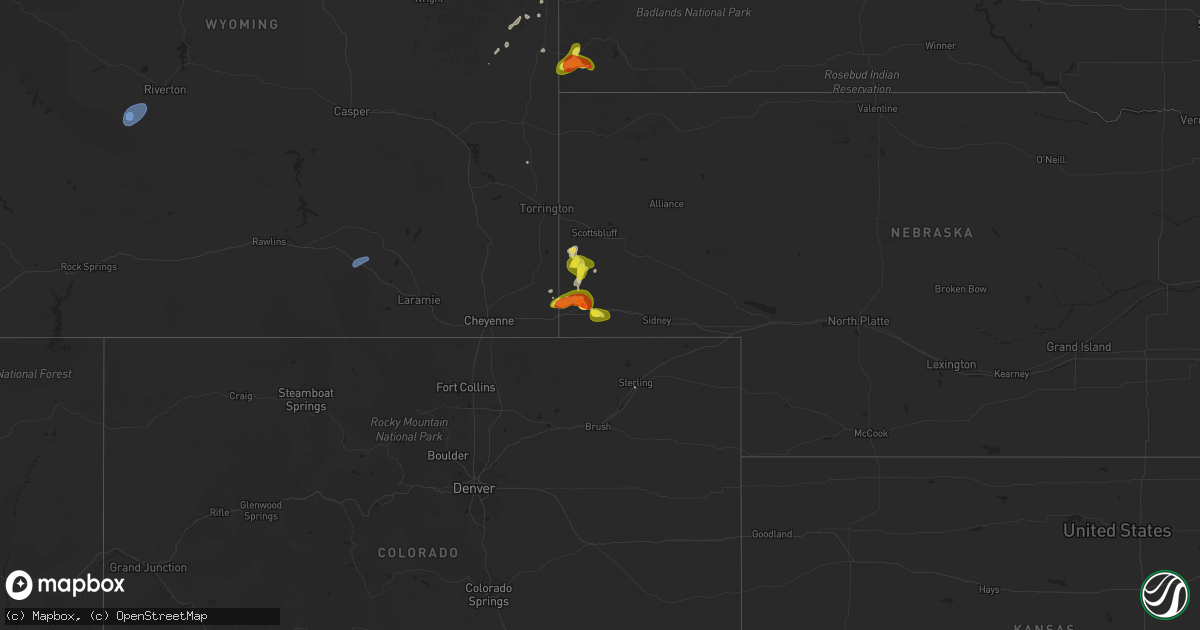
Hail Map on September 10, 2025
Get this storm
September 10 map
$229
one time, instant access
Download today. No call, no setup
Keep the $229
Bought the map and want the full workflow? Apply the entire $229 to a subscription within 7 days. None of it is wasted.
Every map, not just this one
This buys you this map. Subscription and you get every map we run, in the markets you choose from a few cities to whole states to nationwide. Plus real-time alerts the moment a storm fires.
Contact data
Name, contact info, occupancy, even credit band for addresses in the footprint. You go from where it hit to who to call.
Become the source they trust
Unlimited branding weather history reports on demand. You already have the documented answer ready for the property owner, and you are the one who showed up with it.
Property data and RoofTrace estimates
Pull up any address you have got, its value and the exact code rules for that jurisdiction, straight from One Click Code. Then RoofTrace estimates the squares, pitch, and roof value, priced the way you price.
States Impacted by Hail Map on September 10, 2025
Storm reports
South Dakota
| Date | Description |
|---|---|
| 09/10/202512:59 AM CDT | A local report indicates 60 MPH wind near Ellsworth AFB |
| 09/10/202512:40 AM CDT | Wind gust from decaying thunderstorm. |
| 09/10/202512:40 AM CDT | Wind gust from decaying thunderstorm. Red rocks mesonet station 028bh. |
Idaho
| Date | Description |
|---|---|
| 09/09/20259:30 PM CDT | Broken tree branch. Social media report. |
| 09/09/20258:45 PM CDT | Dead tree down across broadway ave in boise. Social media report. |
Montana
| Date | Description |
|---|---|
| 09/10/20251:21 AM CDT | Corrects previous non-tstm wnd gst report from 1 se baker. Asos station kbhk baker. |
| 09/10/202512:00 AM CDT | Mesonet station mtm89 angela w. |
| 09/09/202511:54 PM CDT | Mesonet station ekim8 mosby 16.3nne. |
| 09/09/20259:30 PM CDT | A local report indicates 60 MPH wind near 6 SSW Biddle |
| 09/09/20258:45 PM CDT | A local report indicates 61 MPH wind near 4 W Billings |
| 09/09/20258:44 PM CDT | A local report indicates 61 MPH wind near 6 SW Billings |
Nebraska
| Date | Description |
|---|---|
| 09/09/20258:53 PM CDT | Storm chaser reported quarter sized hail near dix... Ne. |
| 09/09/20258:07 PM CDT | Storm chaser submitted photo of 1.75 inch hail via social media. |
| 09/09/20257:00 PM CDT | Storm spotter reports half dollar sized hail in banner county. |
Arizona
| Date | Description |
|---|---|
| 09/09/20257:54 PM CDT | Asos station ksjn st. Johns airport. |
| 09/09/20257:43 PM CDT | Mesonet station azt12 hwy 377 @ 14 mile hill mm 376. |
Wyoming
| Date | Description |
|---|---|
| 09/10/202512:10 PM CDT | Mesonet station wy22 2.7 nw arlington |
| 09/09/202511:20 PM CDT | Mesonet station pc259 wyopo. |
| 09/09/202511:11 PM CDT | Asos station klnd lander airport. |
| 09/09/202511:10 PM CDT | Mesonet station pc454 moss rock. |
Cities Impacted by Hail Map on September 10, 2025
- Rock River, WY
- Hanna, WY
- Vaughn, NM
- Anton Chico, NM
- Model, CO
- Las Vegas, NM
- John Day, OR
- Fowler, CO
- Mountain City, NV
- Walsenburg, CO
- Lyman, NE
- Wagon Mound, NM
- Edgemont, SD
- Pine Bluffs, WY
- Grand View, ID
- Harrisburg, NE
- Albin, WY
- Bushnell, NE
- Kimball, NE
- Springer, NM
- Dix, NE
- Laurel, MT
- Billings, MT
- Shepherd, MT
- Gillette, WY
- Recluse, WY
- Broadus, MT
- Weston, WY
- Alzada, MT
- Newcastle, WY
- Lander, WY
- Rapid City, SD
- Souris, ND
- Carpio, ND
- Berthold, ND
- Lansford, ND
- Westhope, ND
- Maxbass, ND
- Newburg, ND
- Bottineau, ND
- Marmarth, ND
- Rhame, ND
- Medora, ND
- Belfield, ND
- Amidon, ND
- Bowman, ND
- New England, ND
- Scranton, ND
- Buffalo, SD
- Bantry, ND
- Towner, ND
- Grover, WY
- Willow City, ND