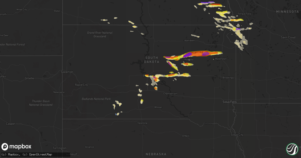
Hail Map in South Dakota on July 25, 2021
Get this storm
July 25 map
$229
one time, instant access
Download today. No call, no setup
Keep the $229
Bought the map and want the full workflow? Apply the entire $229 to a subscription within 7 days. None of it is wasted.
Every map, not just this one
This buys you this map. Subscription and you get every map we run, in the markets you choose from a few cities to whole states to nationwide. Plus real-time alerts the moment a storm fires.
Contact data
Name, contact info, occupancy, even credit band for addresses in the footprint. You go from where it hit to who to call.
Become the source they trust
Unlimited branding weather history reports on demand. You already have the documented answer ready for the property owner, and you are the one who showed up with it.
Property data and RoofTrace estimates
Pull up any address you have got, its value and the exact code rules for that jurisdiction, straight from One Click Code. Then RoofTrace estimates the squares, pitch, and roof value, priced the way you price.
Storm reports in South Dakota
South Dakota
| Date | Description |
|---|---|
| 07/25/20216:46 PM CDT | A local report indicates 1.00 inch wind near 7 SW FAULKTON |
| 07/25/20216:35 PM CDT | Verified by social media photos. Time estimated. |
| 07/25/20216:32 PM CDT | A local report indicates 1.75 inch wind near 7 W MILLER DALE COLONY |
| 07/25/20216:20 PM CDT | Radar estimated time. |
| 07/25/20215:42 PM CDT | Quarter to golf ball size hail reported on social media with photo. Time estimated. |
| 07/25/20214:38 AM CDT | At 938 PM CDT, a severe thunderstorm was located over Sonora, or 17 miles south of Wahpeton, moving east at 30 mph. HAZARD...60 mph wind gusts and quarter size hail. SOURCE...Radar indicated. IMPACT...Hail damage to vehicles is expected. Expect wind damage to roofs, siding, and trees. This severe thunderstorm will be near... Fairmount and Lamars around 945 PM CDT. Blackmer around 950 PM CDT.This includes Interstate 29 between mile markers 3 and 14. |
| 07/25/20213:54 AM CDT | At 853 PM CDT, a severe thunderstorm was located over Wallace, or 16 miles northeast of Clark, moving east at 35 mph. HAZARD...Half dollar size hail. SOURCE...Radar indicated. IMPACT...Damage to vehicles is expected. This severe thunderstorm will be near... Grass Lake around 900 PM CDT. Florence and Medicine Lake around 905 PM CDT.Other locations in the path of this severe thunderstorm includeWatertown, Dakota Sioux Casino, Watertown City Park, Rauville,Waverly and South Shore. |
| 07/25/20213:11 AM CDT | At 811 PM CDT, a severe thunderstorm was located near Turton, or 17 miles northwest of Clark, moving east at 40 mph. HAZARD...Golf ball size hail. SOURCE...Public. At 811 pm, golf ball size hail was reported in Turton. IMPACT...People and animals outdoors will be injured. Expect damage to roofs, siding, windows, and vehicles. This severe thunderstorm will be near... Crocker around 830 PM CDT.Other locations in the path of this severe thunderstorm includeHillcrest Colony, Bradley, Garden City and Swan Lake. |
| 07/25/20212:30 AM CDT | At 730 PM CDT, a severe thunderstorm was located 8 miles south of Polo, or 12 miles northwest of Miller, moving southeast at 20 mph. HAZARD...Half dollar size hail. SOURCE...Radar indicated. IMPACT...Damage to vehicles is expected. Locations impacted include... Miller and St. Lawrence. |
| 07/25/20212:29 AM CDT | At 729 PM CDT, a severe thunderstorm was located 6 miles northwest of Wood, or 8 miles east of White River, moving southwest at 10 mph. HAZARD...60 mph wind gusts and quarter size hail. SOURCE...Radar indicated. IMPACT...Hail damage to vehicles is expected. Expect wind damage to roofs, siding, and trees. Locations impacted include... White River, Wood, Butte Creek, Horse Creek and Swift Bear. |
| 07/25/20212:19 AM CDT | At 718 PM CDT, a severe thunderstorm was located near Wessington, or 18 miles southeast of Miller, moving east at 35 mph. HAZARD...60 mph wind gusts and quarter size hail. SOURCE...Radar indicated. IMPACT...Hail damage to vehicles is expected. Expect wind damage to roofs, siding, and trees. This severe thunderstorm will be near... Wolsey around 735 PM CDT. Virgil around 740 PM CDT.Other locations impacted by this severe thunderstorm includeBroadland. |
| 07/25/20212:03 AM CDT | At 703 PM CDT, a severe thunderstorm was located 11 miles west of Polo, or 17 miles north of Highmore, moving east at 15 mph. HAZARD...60 mph wind gusts and half dollar size hail. SOURCE...Radar indicated. IMPACT...Hail damage to vehicles is expected. Expect wind damage to roofs, siding, and trees. This severe thunderstorm will remain over mainly rural areas of northwestern Hand and northeastern Hyde Counties. |
| 07/25/20211:43 AM CDT | At 643 PM CDT, a severe thunderstorm was located near Fate Dam, or 7 miles northeast of Presho, moving southeast at 10 mph. HAZARD...60 mph wind gusts and quarter size hail. SOURCE...Radar indicated. IMPACT...Hail damage to vehicles is expected. Expect wind damage to roofs, siding, and trees. Locations impacted include... Byre Lake and Kennebec. |
| 07/25/20211:41 AM CDT | At 640 PM CDT, a severe thunderstorm was located near Degrey Rec Area, or 19 miles southeast of Pierre, moving southeast at 10 mph. HAZARD...Ping pong ball size hail and 60 mph wind gusts. SOURCE...Radar indicated. IMPACT...People and animals outdoors will be injured. Expect hail damage to roofs, siding, windows, and vehicles. Expect wind damage to roofs, siding, and trees. This severe thunderstorm will remain over mainly rural areas of southeastern Stanley and southeastern Hughes Counties, including the following locations... northwestern Lower Brule Reservation. |
| 07/25/20211:24 AM CDT | At 624 PM CDT, a severe thunderstorm was located 9 miles south of Seneca, or 16 miles southwest of Faulkton, moving east at 30 mph. HAZARD...60 mph wind gusts and quarter size hail. SOURCE...Radar indicated. IMPACT...Hail damage to vehicles is expected. Expect wind damage to roofs, siding, and trees. Locations impacted include... Orient. |
| 07/25/20211:20 AM CDT | At 619 PM CDT, a severe thunderstorm was located 8 miles northeast of Stephan, or 11 miles south of Highmore, moving east at 40 mph. HAZARD...60 mph wind gusts and quarter size hail. SOURCE...Radar indicated. IMPACT...Hail damage to vehicles is expected. Expect wind damage to roofs, siding, and trees. Locations impacted include... Miller Dale Colony, Sunshine Bible Academy and Pleasant Valley Country Church. |
| 07/25/20211:03 AM CDT | At 602 PM CDT, a severe thunderstorm was located over Rousseau, or 14 miles east of Pierre, moving east at 10 mph. HAZARD...60 mph wind gusts and half dollar size hail. SOURCE...Radar indicated. IMPACT...Hail damage to vehicles is expected. Expect wind damage to roofs, siding, and trees. Locations impacted include... Degrey Rec Area. |
| 07/25/202112:55 AM CDT | At 555 PM CDT, a severe thunderstorm was located over Westover, or 9 miles south of Murdo, moving east at 20 mph. HAZARD...Ping pong ball size hail and 60 mph wind gusts. SOURCE...Radar indicated. IMPACT...People and animals outdoors will be injured. Expect hail damage to roofs, siding, windows, and vehicles. Expect wind damage to roofs, siding, and trees. This severe thunderstorm will remain over mainly rural areas of southeastern Jones County. |
| 07/25/202112:37 AM CDT | At 537 PM CDT/437 PM MDT/, a severe thunderstorm was located over Fort Pierre, moving east at 20 mph. HAZARD...60 mph wind gusts and quarter size hail. SOURCE...Radar indicated. IMPACT...Hail damage to vehicles is expected. Expect wind damage to roofs, siding, and trees. This severe thunderstorm will be near... Pierre around 540 PM CDT. |
| 07/24/20219:07 PM CDT | Verified by social media photos. Time estimated. |
| 07/24/20219:07 PM CDT | Time estimated. |
| 07/24/20219:02 PM CDT | A local report indicates 1.75 inch wind near WALLACE |
| 07/24/20218:11 PM CDT | A local report indicates 1.75 inch wind near TURTON |
| 07/24/20218:07 PM CDT | A local report indicates 1.25 inch wind near TURTON |
| 07/24/20218:04 PM CDT | Pea to quarter size hail |
| 07/24/20217:40 PM CDT | Corrects previous hail report from 2 n ashton. Verified by photo. Time estimated by radar. |
| 07/24/20217:39 PM CDT | A local report indicates 1.00 inch wind near 8 NNW MILLER |
| 07/24/20217:37 PM CDT | Time estimated by radar. |
| 07/24/20217:36 PM CDT | Verified by photo. Time estimated by radar. |
| 07/24/20217:32 PM CDT | Dime to half dollar hail |
| 07/24/20217:19 PM CDT | 5 minutes of hail... Mostly small hail but a couple stones were the size of ping pongs. |
| 07/24/20217:15 PM CDT | A local report indicates 63 MPH wind near 1 ESE MARTIN |
| 07/24/20217:07 PM CDT | A local report indicates 1.50 inch wind near 12 W POLO |
All States Impacted by Hail Map on July 25, 2021
Cities Impacted by Hail Map on July 25, 2021
- Wanblee, SD
- Ashton, SD
- Corona, NM
- Sheridan Lake, CO
- Eads, CO
- Groom, TX
- Pampa, TX
- Cordell, OK
- Leedey, OK
- Seneca, SD
- Campbell, MN
- Fairmount, ND
- Nashua, MN
- Wendell, MN
- Las Animas, CO
- Littlefield, AZ
- Holly, CO
- Lamar, CO
- Syracuse, KS
- Enterprise, UT
- Saint George, UT
- Moline, KS
- Clarendon, TX
- Mclean, TX
- Miami, TX
- Limon, CO
- Cedar City, UT
- Mullinville, KS
- Hettinger, ND
- Ulysses, KS
- Highmore, SD
- Miller, SD
- Tulare, SD
- Ortonville, MN
- Okeene, OK
- Fairview, OK
- Foss, OK
- Burlington, CO
- Bethune, CO
- Levelland, TX
- Claire City, SD
- Veblen, SD
- Enderlin, ND
- Nome, ND
- Kathryn, ND
- New Effington, SD
- Altus, OK
- Leonard, ND
- Walcott, ND
- Frohna, MO
- Uniontown, MO
- Perryville, MO
- Sheldon, ND
- Tell, TX
- Childress, TX
- Stratton, CO
- Vona, CO
- Mayfield, KS
- Wellington, KS
- Panhandle, TX
- Amarillo, TX
- Litchville, ND
- Fort Ransom, ND
- Wood, SD
- White River, SD
- Okarche, OK
- Blunt, SD
- Fort Pierre, SD
- Pierre, SD
- Harrold, SD
- Ames, OK
- Happy, TX
- Tulia, TX
- Lisbon, ND
- Kit Carson, CO
- Haswell, CO
- Flomot, TX
- Caliente, NV
- Bucklin, KS
- Dodge City, KS
- Jetmore, KS
- Ford, KS
- Wright, KS
- Spearville, KS
- Wyndmere, ND
- Barney, ND
- Selfridge, ND
- Isabella, OK
- Aline, OK
- Waynoka, OK
- Cleo Springs, OK
- Eldorado, OK
- Arapaho, OK
- Clinton, OK
- Canadian, TX
- Floydada, TX
- Custer City, OK
- Rosholt, SD
- Raymond, SD
- Wallace, SD
- Bradley, SD
- Watertown, SD
- Florence, SD
- Clark, SD
- Conde, SD
- Midland, TX
- Arriba, CO
- Martin, SD
- Roaring Springs, TX
- Presho, SD
- Littlefield, TX
- Lockney, TX
- Plainview, TX
- Matador, TX
- Dimmitt, TX
- Muleshoe, TX
- Redfield, SD
- Cuba, KS
- Agenda, KS
- Munden, KS
- Belleville, KS
- Benton, KY
- Gilbertsville, KY
- Mooreton, ND
- Mantador, ND
- Colfax, ND
- Dumont, MN
- Rockham, SD
- Cheyenne Wells, CO
- Two Buttes, CO
- Walsh, CO
- Desert Center, CA
- Yuma, CO
- Spivey, KS
- McLaughlin, SD
- Perryton, TX
- Pine Valley, UT
- Amsterdam, MO
- Butler, MO
- Golden Valley, AZ
- Kingman, AZ
- Overton, NV
- Marion, ND
- Kress, TX
- Canute, OK
- Butler, OK
- Elk City, OK
- Seibert, CO
- Flagler, CO
- Oxford, KS
- Haviland, KS
- Corn, OK
- Ralls, TX
- Selden, KS
- Murdo, SD
- Petersburg, TX
- Johnson, KS
- Manter, KS
- Cope, CO
- Beaver, OK
- Turton, SD
- Cayuga, ND
- Wiley, CO
- Drummond, OK
- Claude, TX
- Gardendale, TX
- Turon, KS
- Wahpeton, ND
- Kingman, KS
- Hoxie, KS
- Odessa, MN
- Clinton, MN
- Hasty, CO
- McClave, CO
- Paragonah, UT
- Protection, KS
- Republican City, NE
- Foxhome, MN
- Breckenridge, MN
- Vulcan, MO
- Piedmont, MO
- Ellington, MO
- Andrews, TX
- Long Valley, SD
- Wolsey, SD
- Saint Lawrence, SD
- Wessington, SD
- Claremont, SD
- Groton, SD
- Columbia, SD
- Odessa, TX
- Cambridge, KS
- Abernathy, TX
- Anton, TX
- Silverton, TX
- Orient, SD
- Ree Heights, SD
- Shidler, OK
- Linn, KS
- Washington, KS
- Richfield, KS
- Shamrock, TX
- Lidgerwood, ND
- Faulkton, SD
- Doland, SD
- Garden City, SD
- Greenfield, OK
- Watonga, OK
- Paducah, TX
- Cee Vee, TX
- Joes, CO
- Coldwater, KS
- Carrizozo, NM
- Milnor, ND
- Kingfisher, OK
- Geary, OK
- Hitchcock, OK
- Omega, OK
- Calumet, OK
- Cedar Vale, KS
- Slaton, TX
- Winfield, KS
- Burden, KS
- Wheaton, MN
- Vinita, OK
- Chelsea, OK
- Karval, CO
- Collinsville, OK
- Lahoma, OK
- Pawhuska, OK
- Weatherford, OK
- Argonia, KS
- Sharon, OK
- Mellette, SD
- Marathon, TX
- Bartlesville, OK
- Greensburg, KS
- Coffeyville, KS
- Appleton, MN
- Orangeburg, NY
- Blauvelt, NY
- Valley Cottage, NY
- Tarrytown, NY
- New City, NY
- West Nyack, NY
- Irvington, NY
- Nanuet, NY
- Nyack, NY
- Arnett, OK
- Elmer, OK
- Olustee, OK
- Kennebec, SD
- Lower Brule, SD
- Sayre, OK
- Chokio, MN
- Graceville, MN
- Mountain View, OK
- Satanta, KS
- Stanton, TX
- Booker, TX
- Henry, SD
- Harper, KS
- Shallowater, TX
- Milford, UT
- Hammon, OK
- Beardsley, MN
- Sedan, KS
- Kendall, KS
- Higgins, TX
- Granada, CO
- New Leipzig, ND
- Elgin, ND
- Indian Springs, NV
- Hoffman, MN
- Herman, MN
- Barrett, MN
- Morrowville, KS
- Barnes, KS
- Greenleaf, KS
- Milan, KS
- Kirk, CO
- Sugar City, CO
- Clyde, KS
- Clifton, KS
- Mahaska, KS
- Holabird, SD
- Dumas, TX
- Hankinson, ND
- Adrian, TX
- Tuthill, SD
- Barnsdall, OK
- Big Cabin, OK
- Morris, MN
- Correll, MN
- Alberta, MN
- Sisseton, SD
- Bellingham, MN
- Donnelly, MN
- Madison, MN
- Holloway, MN
- Ashland, KS
- Wilmore, KS
- Skiatook, OK
- Woodrow, CO
- Sunray, TX
- Geuda Springs, KS
- South Haven, KS
- Conway Springs, KS
- Tintah, MN
- Norcross, MN
- Baldwin City, KS
- Lakin, KS
- Mcleod, ND
- Northville, SD
- Monroe, VA
- Delaware, OK
- Hollenberg, KS
- Tulsa, OK
- Anadarko, OK
- Cement, OK
- Madison Heights, VA
- Draper, SD
- Evansville, MN
- Elbow Lake, MN
- Hitchcock, SD
- Memphis, TX
- Wellington, TX
- Headrick, OK
- Tipton, OK
- Cadiz, KY
- South Shore, SD
- Wakpala, SD
- Chillicothe, TX
- Thomas, OK
- Hudson, KS
- St John, KS
- Sylvia, KS
- Sublette, KS
- Tunas, MO
- Macks Creek, MO
- Quanah, TX
- Offerle, KS
- Lamoure, ND
- Paola, KS
- Amoret, MO
- Stafford, KS
- Greenville, UT
- Ruidoso, NM
- Webster, SD
- Lebanon, SD
- Fergus Falls, MN
- Hedley, TX
- Nellis Afb, NV
- North Las Vegas, NV
- Las Vegas, NV
- Sloan, NV
- Henderson, NV
- Amargosa Valley, NV
- Freedom, OK
- Mooreland, OK
- Duke, OK
- Frederick, OK
- Broken Arrow, OK
- Oologah, OK
- Owasso, OK
- Ramona, OK
- Catoosa, OK
- Ochelata, OK
- Claremore, OK
- Sperry, OK
- Vera, OK
- Southard, OK
- Loyal, OK
- Longdale, OK
- Union City, OK
- El Reno, OK
- Dill City, OK
- Bessie, OK


