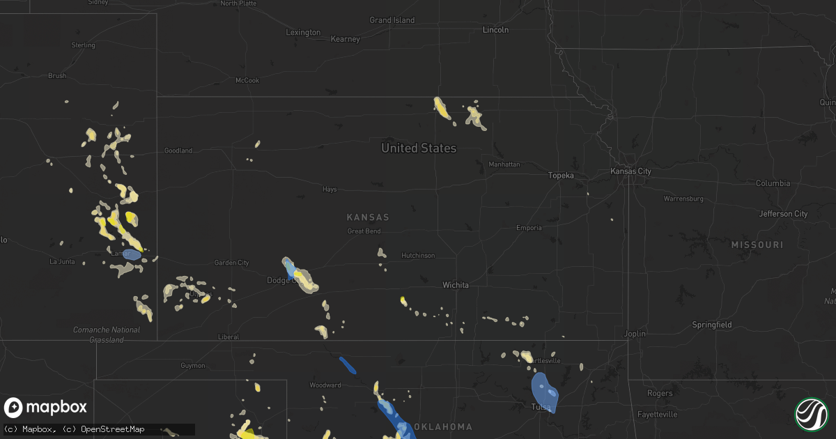
Hail Map in Kansas on July 25, 2021
Get this storm
July 25 map
$229
one time, instant access
Download today. No call, no setup
Keep the $229
Bought the map and want the full workflow? Apply the entire $229 to a subscription within 7 days. None of it is wasted.
Every map, not just this one
This buys you this map. Subscription and you get every map we run, in the markets you choose from a few cities to whole states to nationwide. Plus real-time alerts the moment a storm fires.
Contact data
Name, contact info, occupancy, even credit band for addresses in the footprint. You go from where it hit to who to call.
Become the source they trust
Unlimited branding weather history reports on demand. You already have the documented answer ready for the property owner, and you are the one who showed up with it.
Property data and RoofTrace estimates
Pull up any address you have got, its value and the exact code rules for that jurisdiction, straight from One Click Code. Then RoofTrace estimates the squares, pitch, and roof value, priced the way you price.
Storm reports in Kansas
Kansas
| Date | Description |
|---|---|
| 07/25/20211:50 PM CDT | 4 inch diameter tree limbs blown down. |
| 07/25/20211:50 PM CDT | 1 to 2 inch diameter tree limbs blown down. |
| 07/25/20211:27 PM CDT | Power poles blown down at u.s. Highway 50 and 121 rd. |
| 07/25/202112:52 PM CDT | Asos station kddc dodge city regional airport. |
| 07/25/202112:35 PM CDT | Tree blown over onto hot tub and roof of house. Damage to roof and hot tub. Tree was partially dead. |
| 07/25/20218:03 AM CDT | 58 mph wind with thunderstorm outflow. Reported at kcnk. |
| 07/25/20217:54 AM CDT | At 1254 PM CDT, a severe thunderstorm was located near Wright, moving southeast at 10 mph. HAZARD...70 mph wind gusts. SOURCE...Radar indicated. IMPACT...Expect considerable tree damage. Damage is likely to mobile homes, roofs, and outbuildings. Locations impacted include... Dodge City, Wright and Ft. Dodge. |
| 07/25/20217:31 AM CDT | At 1231 PM CDT, a severe thunderstorm with strong winds was located near Wright, moving southeast at 15 mph. Another area of strong winds is located 10 miles south of Jetmore moving southeast at 15 mph. HAZARD...60 mph wind gusts. SOURCE...Radar indicated. IMPACT...Expect damage to roofs, siding, and trees. This severe thunderstorm will be near... Dodge City around 1245 PM CDT.Other locations in the path of this severe thunderstorm includeWright and Ft. Dodge. |
| 07/25/20217:29 AM CDT | At 1228 PM CDT, a severe thunderstorm was located 13 miles south of Kingman, moving southeast at 10 mph. HAZARD...60 mph wind gusts and quarter size hail. SOURCE...Radar indicated. IMPACT...Hail damage to vehicles is expected. Expect wind damage to roofs, siding, and trees. This severe thunderstorm will remain over mainly rural areas of north central Harper and south central Kingman Counties, including the following locations... Spivey, Rago and Zenda. |
| 07/24/20218:40 PM CDT | At 140 PM CDT, a severe thunderstorm was located near Windhorst, moving southeast at 20 mph. HAZARD...60 mph wind gusts. SOURCE...Radar indicated. IMPACT...Expect damage to roofs, siding, and trees. Locations impacted include... Mullinville. |
All States Impacted by Hail Map on July 25, 2021
Cities Impacted by Hail Map on July 25, 2021
- Wanblee, SD
- Ashton, SD
- Corona, NM
- Sheridan Lake, CO
- Eads, CO
- Groom, TX
- Pampa, TX
- Cordell, OK
- Leedey, OK
- Seneca, SD
- Campbell, MN
- Fairmount, ND
- Nashua, MN
- Wendell, MN
- Las Animas, CO
- Littlefield, AZ
- Holly, CO
- Lamar, CO
- Syracuse, KS
- Enterprise, UT
- Saint George, UT
- Moline, KS
- Clarendon, TX
- Mclean, TX
- Miami, TX
- Limon, CO
- Cedar City, UT
- Mullinville, KS
- Hettinger, ND
- Ulysses, KS
- Highmore, SD
- Miller, SD
- Tulare, SD
- Ortonville, MN
- Okeene, OK
- Fairview, OK
- Foss, OK
- Burlington, CO
- Bethune, CO
- Levelland, TX
- Claire City, SD
- Veblen, SD
- Enderlin, ND
- Nome, ND
- Kathryn, ND
- New Effington, SD
- Altus, OK
- Leonard, ND
- Walcott, ND
- Frohna, MO
- Uniontown, MO
- Perryville, MO
- Sheldon, ND
- Tell, TX
- Childress, TX
- Stratton, CO
- Vona, CO
- Mayfield, KS
- Wellington, KS
- Panhandle, TX
- Amarillo, TX
- Litchville, ND
- Fort Ransom, ND
- Wood, SD
- White River, SD
- Okarche, OK
- Blunt, SD
- Fort Pierre, SD
- Pierre, SD
- Harrold, SD
- Ames, OK
- Happy, TX
- Tulia, TX
- Lisbon, ND
- Kit Carson, CO
- Haswell, CO
- Flomot, TX
- Caliente, NV
- Bucklin, KS
- Dodge City, KS
- Jetmore, KS
- Ford, KS
- Wright, KS
- Spearville, KS
- Wyndmere, ND
- Barney, ND
- Selfridge, ND
- Isabella, OK
- Aline, OK
- Waynoka, OK
- Cleo Springs, OK
- Eldorado, OK
- Arapaho, OK
- Clinton, OK
- Canadian, TX
- Floydada, TX
- Custer City, OK
- Rosholt, SD
- Raymond, SD
- Wallace, SD
- Bradley, SD
- Watertown, SD
- Florence, SD
- Clark, SD
- Conde, SD
- Midland, TX
- Arriba, CO
- Martin, SD
- Roaring Springs, TX
- Presho, SD
- Littlefield, TX
- Lockney, TX
- Plainview, TX
- Matador, TX
- Dimmitt, TX
- Muleshoe, TX
- Redfield, SD
- Cuba, KS
- Agenda, KS
- Munden, KS
- Belleville, KS
- Benton, KY
- Gilbertsville, KY
- Mooreton, ND
- Mantador, ND
- Colfax, ND
- Dumont, MN
- Rockham, SD
- Cheyenne Wells, CO
- Two Buttes, CO
- Walsh, CO
- Desert Center, CA
- Yuma, CO
- Spivey, KS
- McLaughlin, SD
- Perryton, TX
- Pine Valley, UT
- Amsterdam, MO
- Butler, MO
- Golden Valley, AZ
- Kingman, AZ
- Overton, NV
- Marion, ND
- Kress, TX
- Canute, OK
- Butler, OK
- Elk City, OK
- Seibert, CO
- Flagler, CO
- Oxford, KS
- Haviland, KS
- Corn, OK
- Ralls, TX
- Selden, KS
- Murdo, SD
- Petersburg, TX
- Johnson, KS
- Manter, KS
- Cope, CO
- Beaver, OK
- Turton, SD
- Cayuga, ND
- Wiley, CO
- Drummond, OK
- Claude, TX
- Gardendale, TX
- Turon, KS
- Wahpeton, ND
- Kingman, KS
- Hoxie, KS
- Odessa, MN
- Clinton, MN
- Hasty, CO
- McClave, CO
- Paragonah, UT
- Protection, KS
- Republican City, NE
- Foxhome, MN
- Breckenridge, MN
- Vulcan, MO
- Piedmont, MO
- Ellington, MO
- Andrews, TX
- Long Valley, SD
- Wolsey, SD
- Saint Lawrence, SD
- Wessington, SD
- Claremont, SD
- Groton, SD
- Columbia, SD
- Odessa, TX
- Cambridge, KS
- Abernathy, TX
- Anton, TX
- Silverton, TX
- Orient, SD
- Ree Heights, SD
- Shidler, OK
- Linn, KS
- Washington, KS
- Richfield, KS
- Shamrock, TX
- Lidgerwood, ND
- Faulkton, SD
- Doland, SD
- Garden City, SD
- Greenfield, OK
- Watonga, OK
- Paducah, TX
- Cee Vee, TX
- Joes, CO
- Coldwater, KS
- Carrizozo, NM
- Milnor, ND
- Kingfisher, OK
- Geary, OK
- Hitchcock, OK
- Omega, OK
- Calumet, OK
- Cedar Vale, KS
- Slaton, TX
- Winfield, KS
- Burden, KS
- Wheaton, MN
- Vinita, OK
- Chelsea, OK
- Karval, CO
- Collinsville, OK
- Lahoma, OK
- Pawhuska, OK
- Weatherford, OK
- Argonia, KS
- Sharon, OK
- Mellette, SD
- Marathon, TX
- Bartlesville, OK
- Greensburg, KS
- Coffeyville, KS
- Appleton, MN
- Orangeburg, NY
- Blauvelt, NY
- Valley Cottage, NY
- Tarrytown, NY
- New City, NY
- West Nyack, NY
- Irvington, NY
- Nanuet, NY
- Nyack, NY
- Arnett, OK
- Elmer, OK
- Olustee, OK
- Kennebec, SD
- Lower Brule, SD
- Sayre, OK
- Chokio, MN
- Graceville, MN
- Mountain View, OK
- Satanta, KS
- Stanton, TX
- Booker, TX
- Henry, SD
- Harper, KS
- Shallowater, TX
- Milford, UT
- Hammon, OK
- Beardsley, MN
- Sedan, KS
- Kendall, KS
- Higgins, TX
- Granada, CO
- New Leipzig, ND
- Elgin, ND
- Indian Springs, NV
- Hoffman, MN
- Herman, MN
- Barrett, MN
- Morrowville, KS
- Barnes, KS
- Greenleaf, KS
- Milan, KS
- Kirk, CO
- Sugar City, CO
- Clyde, KS
- Clifton, KS
- Mahaska, KS
- Holabird, SD
- Dumas, TX
- Hankinson, ND
- Adrian, TX
- Tuthill, SD
- Barnsdall, OK
- Big Cabin, OK
- Morris, MN
- Correll, MN
- Alberta, MN
- Sisseton, SD
- Bellingham, MN
- Donnelly, MN
- Madison, MN
- Holloway, MN
- Ashland, KS
- Wilmore, KS
- Skiatook, OK
- Woodrow, CO
- Sunray, TX
- Geuda Springs, KS
- South Haven, KS
- Conway Springs, KS
- Tintah, MN
- Norcross, MN
- Baldwin City, KS
- Lakin, KS
- Mcleod, ND
- Northville, SD
- Monroe, VA
- Delaware, OK
- Hollenberg, KS
- Tulsa, OK
- Anadarko, OK
- Cement, OK
- Madison Heights, VA
- Draper, SD
- Evansville, MN
- Elbow Lake, MN
- Hitchcock, SD
- Memphis, TX
- Wellington, TX
- Headrick, OK
- Tipton, OK
- Cadiz, KY
- South Shore, SD
- Wakpala, SD
- Chillicothe, TX
- Thomas, OK
- Hudson, KS
- St John, KS
- Sylvia, KS
- Sublette, KS
- Tunas, MO
- Macks Creek, MO
- Quanah, TX
- Offerle, KS
- Lamoure, ND
- Paola, KS
- Amoret, MO
- Stafford, KS
- Greenville, UT
- Ruidoso, NM
- Webster, SD
- Lebanon, SD
- Fergus Falls, MN
- Hedley, TX
- Nellis Afb, NV
- North Las Vegas, NV
- Las Vegas, NV
- Sloan, NV
- Henderson, NV
- Amargosa Valley, NV
- Freedom, OK
- Mooreland, OK
- Duke, OK
- Frederick, OK
- Broken Arrow, OK
- Oologah, OK
- Owasso, OK
- Ramona, OK
- Catoosa, OK
- Ochelata, OK
- Claremore, OK
- Sperry, OK
- Vera, OK
- Southard, OK
- Loyal, OK
- Longdale, OK
- Union City, OK
- El Reno, OK
- Dill City, OK
- Bessie, OK


