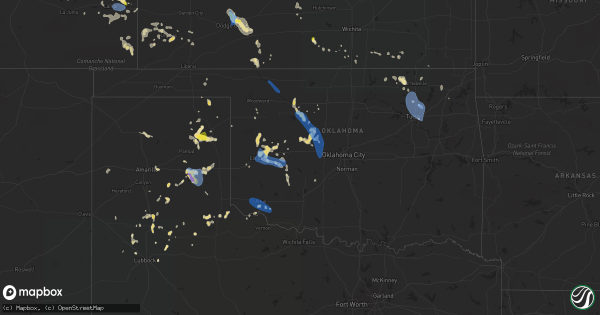
Hail Map in Oklahoma on July 25, 2021
Get this storm
July 25 map
$229
one time, instant access
Download today. No call, no setup
Keep the $229
Bought the map and want the full workflow? Apply the entire $229 to a subscription within 7 days. None of it is wasted.
Every map, not just this one
This buys you this map. Subscription and you get every map we run, in the markets you choose from a few cities to whole states to nationwide. Plus real-time alerts the moment a storm fires.
Contact data
Name, contact info, occupancy, even credit band for addresses in the footprint. You go from where it hit to who to call.
Become the source they trust
Unlimited branding weather history reports on demand. You already have the documented answer ready for the property owner, and you are the one who showed up with it.
Property data and RoofTrace estimates
Pull up any address you have got, its value and the exact code rules for that jurisdiction, straight from One Click Code. Then RoofTrace estimates the squares, pitch, and roof value, priced the way you price.
Storm reports in Oklahoma
Oklahoma
| Date | Description |
|---|---|
| 07/25/20216:20 PM CDT | A local report indicates 70 MPH wind near 3 S ALTUS |
| 07/25/20216:19 PM CDT | Report from mping: 3-inch tree limbs broken; power poles broken. |
| 07/25/20216:15 PM CDT | A local report indicates 64 MPH wind near 3 S ALTUS |
| 07/25/20216:15 PM CDT | Nws employee reports 1 inch tree limbs broken and shingles blown off. Time estimated from radar. |
| 07/25/20216:01 PM CDT | A local report indicates 62 MPH wind near TULSA |
| 07/25/20216:01 PM CDT | Limbs down... Shingles blown off roofs |
| 07/25/20216:01 PM CDT | Tul asos measured peak wind gust of 63 mph. |
| 07/25/20216:01 PM CDT | Report from mping: 1-inch tree limbs broken; shingles blown off. |
| 07/25/20216:00 PM CDT | Picture relayed via social media of 6-12 inch diameter tree branch blown over onto car. |
| 07/25/20215:50 PM CDT | Corrects previous tstm wnd dmg report from 2 sse collinsville. Report from mping: 3-inch tree limbs broken; power poles broken - time estimated form radar. |
| 07/25/20215:50 PM CDT | 6-12 inch tree limbs snapped. Picture from social media. Time estimated from radar. |
| 07/25/20213:40 PM CDT | A local report indicates 69 MPH wind near 3 SSW FREEDOM |
| 07/25/20214:23 AM CDT | At 923 PM CDT, a severe thunderstorm was located near Verden, moving north at 20 mph. HAZARD...60 mph wind gusts and quarter size hail. SOURCE...Radar indicated. IMPACT...Hail damage to vehicles is expected. Expect wind damage to roofs, siding, and trees. Locations impacted include... Verden, Pocasset, Lake Chickasha and Laverty. |
| 07/25/20214:12 AM CDT | At 912 AM CDT, a severe thunderstorm was located 6 miles west of Vici, moving southeast at 5 mph. HAZARD...60 mph wind gusts and quarter size hail. SOURCE...Radar indicated. IMPACT...Hail damage to vehicles is expected. Expect wind damage to roofs, siding, and trees. Locations impacted include... Vici. |
| 07/25/20213:38 AM CDT | At 838 PM CDT, a severe thunderstorm was located near Burns Flat, moving southeast at 20 mph. HAZARD...60 mph wind gusts and quarter size hail. SOURCE...Radar indicated. IMPACT...Hail damage to vehicles is expected. Expect wind damage to roofs, siding, and trees. Locations impacted include... Cordell, Burns Flat, Sentinel, Dill City and Rocky. |
| 07/25/20213:12 AM CDT | At 811 PM CDT, a severe thunderstorm was located near Moorewood, moving north at 25 mph. HAZARD...60 mph wind gusts and quarter size hail. SOURCE...Radar indicated. IMPACT...Hail damage to vehicles is expected. Expect wind damage to roofs, siding, and trees. Locations impacted include... Leedey, Camargo, Angora and Moorewood. |
| 07/25/20212:34 AM CDT | At 733 PM CDT, severe thunderstorms were located along a line extending from 4 miles northeast of Kingfisher to 4 miles northeast of Greenfield to 3 miles southwest of Arapaho to near Canute, moving south at 15 mph. HAZARD...60 mph wind gusts and quarter size hail. SOURCE...Radar indicated. IMPACT...Hail damage to vehicles is expected. Expect wind damage to roofs, siding, and trees. Locations impacted include... Northwestern Oklahoma City, El Reno, Elk City, Weatherford, Clinton, Kingfisher, Cordell, Piedmont, Hinton, Burns Flat, Geary, Okarche, Hydro, Sentinel, Arapaho, Dill City, Canute, Calumet, Corn and Bessie. |
| 07/25/20212:00 AM CDT | At 700 PM CDT, individual severe thunderstorms were located along a broken line extending from near Greenfield to 3 miles south of Thomas to near Butler, moving south at 15 mph. HAZARD...60 mph wind gusts and quarter size hail. SOURCE...Radar indicated. IMPACT...Hail damage to vehicles is expected. Expect wind damage to roofs, siding, and trees. Locations impacted include... Weatherford, Clinton, Watonga, Burns Flat, Geary, Thomas, Hydro, Arapaho, Custer City, Butler, Foss, Bridgeport, Greenfield, Foss Reservoir and Stafford. |
| 07/25/20211:45 AM CDT | At 645 PM CDT, a severe thunderstorm was located near Humphreys, moving east at 10 mph. Additional storms have developed near Tipton. HAZARD...60 mph wind gusts and quarter size hail. SOURCE...Radar indicated. IMPACT...Hail damage to vehicles is expected. Expect wind damage to roofs, siding, and trees. Locations impacted include... Frederick, Tipton, Manitou, Headrick, Humphreys and Hess. |
| 07/25/20211:43 AM CDT | At 643 PM CDT, a severe thunderstorm was located 4 miles northeast of Hitchcock, moving southeast at 20 mph. Additional storms have developed near Kingfisher and Omega. HAZARD...60 mph wind gusts and quarter size hail. SOURCE...Radar indicated. IMPACT...Hail damage to vehicles is expected. Expect wind damage to roofs, siding, and trees. Locations impacted include... Kingfisher, Okeene, Hitchcock, Loyal and Omega. |
| 07/25/202112:54 AM CDT | At 554 PM CDT, a severe thunderstorm was located over Collinsville, moving southeast at 30 mph. HAZARD...60 mph wind gusts. SOURCE...Radar indicated. IMPACT...Expect damage to roofs, siding, and trees. Locations in or near the path include... Tulsa... Broken Arrow... Claremore... Owasso... Skiatook... Catoosa... Collinsville... Verdigris... Inola... Taiwah... Tiawah... This includes Interstate 44 between mile markers 230 and 252. |
| 07/25/202112:53 AM CDT | At 553 PM CDT, a severe thunderstorm was located 5 miles southwest of Orienta, moving southeast at 20 mph. HAZARD...60 mph wind gusts and quarter size hail. SOURCE...Radar indicated. IMPACT...Hail damage to vehicles is expected. Expect wind damage to roofs, siding, and trees. Locations impacted include... Fairview, Okeene, Canton, Longdale, Orienta, eastern Canton Lake, Homestead and Southard. |
| 07/25/202112:35 AM CDT | At 535 PM CDT, a severe thunderstorm was located over Ramona, moving southeast at 25 mph. HAZARD...60 mph wind gusts. SOURCE...Radar indicated. IMPACT...Expect damage to roofs, siding, and trees. Locations in or near the path include... Tulsa... Owasso... Skiatook... Collinsville... Sperry... Oologah... Ramona... Ochelata... Avant... Vera... Turley... |
| 07/25/202112:35 AM CDT | At 534 PM CDT, a severe thunderstorm was located over Drummond, moving southeast at 10 mph. HAZARD...60 mph wind gusts and quarter size hail. SOURCE...Radar indicated. IMPACT...Hail damage to vehicles is expected. Expect wind damage to roofs, siding, and trees. Locations impacted include... Hennessey, Waukomis, Drummond and Bison. |
| 07/25/202112:12 AM CDT | At 512 PM CDT, a severe thunderstorm was located 4 miles northwest of Ochelata, moving southeast at 35 mph. HAZARD...60 mph wind gusts and quarter size hail. SOURCE...Radar indicated. IMPACT...Hail damage to vehicles is expected. Expect wind damage to roofs, siding, and trees. Locations in or near the path include... Bartlesville... Skiatook... Barnsdall... Ramona... Wynona... Ochelata... Avant... Vera... Bartlesville Municipal Airport... Watova... Okesa... Tallant... Pershing... Nelagoney... Wolco... |
| 07/25/202112:08 AM CDT | At 507 PM CDT, a severe thunderstorm was located 6 miles west of Aline, moving south at 15 mph. HAZARD...70 mph wind gusts and ping pong ball size hail. SOURCE...Radar indicated. IMPACT...People and animals outdoors will be injured. Expect hail damage to roofs, siding, windows, and vehicles. Expect considerable tree damage. Wind damage is also likely to mobile homes, roofs, and outbuildings. Locations impacted include... Fairview, Cleo Springs and Orienta. |
| 07/24/202111:55 PM CDT | At 455 PM CDT, a severe thunderstorm was located near Osage Hills State Park, moving southeast at 20 mph. HAZARD...60 mph wind gusts and quarter size hail. SOURCE...Radar indicated. IMPACT...Hail damage to vehicles is expected. Expect wind damage to roofs, siding, and trees. Locations in or near the path include... Bartlesville... Barnsdall... Osage Hills State Park... Okesa... Bartlesville Municipal Airport... Tallant... |
| 07/24/202111:34 PM CDT | At 433 PM CDT, a severe thunderstorm was located 5 miles south of Beaver, moving northeast at 5 mph. HAZARD...60 mph wind gusts and half dollar size hail. SOURCE...Radar indicated. IMPACT...Minor damage to roofs, siding, and trees is possible. Hail damage to vehicles is expected. Locations impacted include... Beaver, Mocane, Elmwood, Balko and Boyd. |
| 07/24/202110:48 PM CDT | At 347 PM CDT, a severe thunderstorm was located 6 miles northwest of Freedom, moving southeast at 30 mph. HAZARD...70 mph wind gusts and nickel size hail. SOURCE...Radar indicated. IMPACT...Expect considerable tree damage. Damage is likely to mobile homes, roofs, and outbuildings. Locations impacted include... Waynoka, Freedom, Alabaster Caverns State Park and Camp Houston. |
| 07/24/20219:36 PM CDT | Outflow boundary. |
| 07/24/20218:45 PM CDT | A local report indicates 59 MPH wind near 4 WNW BESSIE |
| 07/24/20218:35 PM CDT | A local report indicates 60 MPH wind near 4 SW EL RENO |
| 07/24/20218:15 PM CDT | A local report indicates 68 MPH wind near 1 NE ELK CITY |
| 07/24/20217:50 PM CDT | A local report indicates 61 MPH wind near 5 SW BUTLER |
| 07/24/20217:28 PM CDT | A local report indicates 70 MPH wind near 4 NW OKARCHE |
All States Impacted by Hail Map on July 25, 2021
Cities Impacted by Hail Map on July 25, 2021
- Wanblee, SD
- Ashton, SD
- Corona, NM
- Sheridan Lake, CO
- Eads, CO
- Groom, TX
- Pampa, TX
- Cordell, OK
- Leedey, OK
- Seneca, SD
- Campbell, MN
- Fairmount, ND
- Nashua, MN
- Wendell, MN
- Las Animas, CO
- Littlefield, AZ
- Holly, CO
- Lamar, CO
- Syracuse, KS
- Enterprise, UT
- Saint George, UT
- Moline, KS
- Clarendon, TX
- Mclean, TX
- Miami, TX
- Limon, CO
- Cedar City, UT
- Mullinville, KS
- Hettinger, ND
- Ulysses, KS
- Highmore, SD
- Miller, SD
- Tulare, SD
- Ortonville, MN
- Okeene, OK
- Fairview, OK
- Foss, OK
- Burlington, CO
- Bethune, CO
- Levelland, TX
- Claire City, SD
- Veblen, SD
- Enderlin, ND
- Nome, ND
- Kathryn, ND
- New Effington, SD
- Altus, OK
- Leonard, ND
- Walcott, ND
- Frohna, MO
- Uniontown, MO
- Perryville, MO
- Sheldon, ND
- Tell, TX
- Childress, TX
- Stratton, CO
- Vona, CO
- Mayfield, KS
- Wellington, KS
- Panhandle, TX
- Amarillo, TX
- Litchville, ND
- Fort Ransom, ND
- Wood, SD
- White River, SD
- Okarche, OK
- Blunt, SD
- Fort Pierre, SD
- Pierre, SD
- Harrold, SD
- Ames, OK
- Happy, TX
- Tulia, TX
- Lisbon, ND
- Kit Carson, CO
- Haswell, CO
- Flomot, TX
- Caliente, NV
- Bucklin, KS
- Dodge City, KS
- Jetmore, KS
- Ford, KS
- Wright, KS
- Spearville, KS
- Wyndmere, ND
- Barney, ND
- Selfridge, ND
- Isabella, OK
- Aline, OK
- Waynoka, OK
- Cleo Springs, OK
- Eldorado, OK
- Arapaho, OK
- Clinton, OK
- Canadian, TX
- Floydada, TX
- Custer City, OK
- Rosholt, SD
- Raymond, SD
- Wallace, SD
- Bradley, SD
- Watertown, SD
- Florence, SD
- Clark, SD
- Conde, SD
- Midland, TX
- Arriba, CO
- Martin, SD
- Roaring Springs, TX
- Presho, SD
- Littlefield, TX
- Lockney, TX
- Plainview, TX
- Matador, TX
- Dimmitt, TX
- Muleshoe, TX
- Redfield, SD
- Cuba, KS
- Agenda, KS
- Munden, KS
- Belleville, KS
- Benton, KY
- Gilbertsville, KY
- Mooreton, ND
- Mantador, ND
- Colfax, ND
- Dumont, MN
- Rockham, SD
- Cheyenne Wells, CO
- Two Buttes, CO
- Walsh, CO
- Desert Center, CA
- Yuma, CO
- Spivey, KS
- McLaughlin, SD
- Perryton, TX
- Pine Valley, UT
- Amsterdam, MO
- Butler, MO
- Golden Valley, AZ
- Kingman, AZ
- Overton, NV
- Marion, ND
- Kress, TX
- Canute, OK
- Butler, OK
- Elk City, OK
- Seibert, CO
- Flagler, CO
- Oxford, KS
- Haviland, KS
- Corn, OK
- Ralls, TX
- Selden, KS
- Murdo, SD
- Petersburg, TX
- Johnson, KS
- Manter, KS
- Cope, CO
- Beaver, OK
- Turton, SD
- Cayuga, ND
- Wiley, CO
- Drummond, OK
- Claude, TX
- Gardendale, TX
- Turon, KS
- Wahpeton, ND
- Kingman, KS
- Hoxie, KS
- Odessa, MN
- Clinton, MN
- Hasty, CO
- McClave, CO
- Paragonah, UT
- Protection, KS
- Republican City, NE
- Foxhome, MN
- Breckenridge, MN
- Vulcan, MO
- Piedmont, MO
- Ellington, MO
- Andrews, TX
- Long Valley, SD
- Wolsey, SD
- Saint Lawrence, SD
- Wessington, SD
- Claremont, SD
- Groton, SD
- Columbia, SD
- Odessa, TX
- Cambridge, KS
- Abernathy, TX
- Anton, TX
- Silverton, TX
- Orient, SD
- Ree Heights, SD
- Shidler, OK
- Linn, KS
- Washington, KS
- Richfield, KS
- Shamrock, TX
- Lidgerwood, ND
- Faulkton, SD
- Doland, SD
- Garden City, SD
- Greenfield, OK
- Watonga, OK
- Paducah, TX
- Cee Vee, TX
- Joes, CO
- Coldwater, KS
- Carrizozo, NM
- Milnor, ND
- Kingfisher, OK
- Geary, OK
- Hitchcock, OK
- Omega, OK
- Calumet, OK
- Cedar Vale, KS
- Slaton, TX
- Winfield, KS
- Burden, KS
- Wheaton, MN
- Vinita, OK
- Chelsea, OK
- Karval, CO
- Collinsville, OK
- Lahoma, OK
- Pawhuska, OK
- Weatherford, OK
- Argonia, KS
- Sharon, OK
- Mellette, SD
- Marathon, TX
- Bartlesville, OK
- Greensburg, KS
- Coffeyville, KS
- Appleton, MN
- Orangeburg, NY
- Blauvelt, NY
- Valley Cottage, NY
- Tarrytown, NY
- New City, NY
- West Nyack, NY
- Irvington, NY
- Nanuet, NY
- Nyack, NY
- Arnett, OK
- Elmer, OK
- Olustee, OK
- Kennebec, SD
- Lower Brule, SD
- Sayre, OK
- Chokio, MN
- Graceville, MN
- Mountain View, OK
- Satanta, KS
- Stanton, TX
- Booker, TX
- Henry, SD
- Harper, KS
- Shallowater, TX
- Milford, UT
- Hammon, OK
- Beardsley, MN
- Sedan, KS
- Kendall, KS
- Higgins, TX
- Granada, CO
- New Leipzig, ND
- Elgin, ND
- Indian Springs, NV
- Hoffman, MN
- Herman, MN
- Barrett, MN
- Morrowville, KS
- Barnes, KS
- Greenleaf, KS
- Milan, KS
- Kirk, CO
- Sugar City, CO
- Clyde, KS
- Clifton, KS
- Mahaska, KS
- Holabird, SD
- Dumas, TX
- Hankinson, ND
- Adrian, TX
- Tuthill, SD
- Barnsdall, OK
- Big Cabin, OK
- Morris, MN
- Correll, MN
- Alberta, MN
- Sisseton, SD
- Bellingham, MN
- Donnelly, MN
- Madison, MN
- Holloway, MN
- Ashland, KS
- Wilmore, KS
- Skiatook, OK
- Woodrow, CO
- Sunray, TX
- Geuda Springs, KS
- South Haven, KS
- Conway Springs, KS
- Tintah, MN
- Norcross, MN
- Baldwin City, KS
- Lakin, KS
- Mcleod, ND
- Northville, SD
- Monroe, VA
- Delaware, OK
- Hollenberg, KS
- Tulsa, OK
- Anadarko, OK
- Cement, OK
- Madison Heights, VA
- Draper, SD
- Evansville, MN
- Elbow Lake, MN
- Hitchcock, SD
- Memphis, TX
- Wellington, TX
- Headrick, OK
- Tipton, OK
- Cadiz, KY
- South Shore, SD
- Wakpala, SD
- Chillicothe, TX
- Thomas, OK
- Hudson, KS
- St John, KS
- Sylvia, KS
- Sublette, KS
- Tunas, MO
- Macks Creek, MO
- Quanah, TX
- Offerle, KS
- Lamoure, ND
- Paola, KS
- Amoret, MO
- Stafford, KS
- Greenville, UT
- Ruidoso, NM
- Webster, SD
- Lebanon, SD
- Fergus Falls, MN
- Hedley, TX
- Nellis Afb, NV
- North Las Vegas, NV
- Las Vegas, NV
- Sloan, NV
- Henderson, NV
- Amargosa Valley, NV
- Freedom, OK
- Mooreland, OK
- Duke, OK
- Frederick, OK
- Broken Arrow, OK
- Oologah, OK
- Owasso, OK
- Ramona, OK
- Catoosa, OK
- Ochelata, OK
- Claremore, OK
- Sperry, OK
- Vera, OK
- Southard, OK
- Loyal, OK
- Longdale, OK
- Union City, OK
- El Reno, OK
- Dill City, OK
- Bessie, OK


