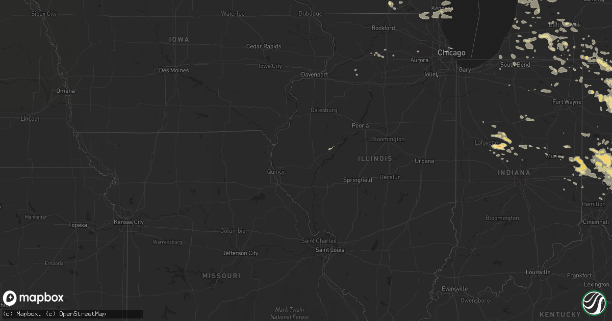
Hail Map in Illinois on July 11, 2011
Get this storm
July 11 map
$229
one time, instant access
Download today. No call, no setup
Keep the $229
Bought the map and want the full workflow? Apply the entire $229 to a subscription within 7 days. None of it is wasted.
Every map, not just this one
This buys you this map. Subscription and you get every map we run, in the markets you choose from a few cities to whole states to nationwide. Plus real-time alerts the moment a storm fires.
Contact data
Name, contact info, occupancy, even credit band for addresses in the footprint. You go from where it hit to who to call.
Become the source they trust
Unlimited branding weather history reports on demand. You already have the documented answer ready for the property owner, and you are the one who showed up with it.
Property data and RoofTrace estimates
Pull up any address you have got, its value and the exact code rules for that jurisdiction, straight from One Click Code. Then RoofTrace estimates the squares, pitch, and roof value, priced the way you price.
Storm reports in Illinois
Illinois
| Date | Description |
|---|---|
| 07/11/20119:50 AM CDT | At the intersection of 88th and utica...there is a 12 inch diameter tree down that snapped off at the base. |
| 07/11/20119:45 AM CDT | Power outages to traffic signals. |
| 07/11/20119:30 AM CDT | 12 inch diameter tree down. |
| 07/11/20119:17 AM CDT | 12 to 15 inch diameter tree down. |
| 07/11/20119:14 AM CDT | Numerous trees and power lines down. One tree fell on a house. |
| 07/11/20119:12 AM CDT | 12 inch diameter tree limb down at the intersection of dayton and willow. |
| 07/11/20119:12 AM CDT | Large tree approximately 18 inches in diameter down at the intersection of goethe st and lasalle st. |
| 07/11/20119:06 AM CDT | 2 foot diameter trees snapped off and utility poles down at the intersection of checker and schaefer in long grove. |
| 07/11/20119:05 AM CDT | Power lines down along with numerous tree branches. 63rd st is blocked from fair view to belmons |
| 07/11/20119:05 AM CDT | Large tree branches down. |
| 07/11/20119:05 AM CDT | Power outages |
| 07/11/20119:01 AM CDT | 15 inch tree uprooted. |
| 07/11/20119:00 AM CDT | Telephone lines down along with large trees in prairie view. A roof is also reported to be blown off. |
| 07/11/20118:55 AM CDT | 24 inch diameter tree down at the intersection of oakton and wesley. Other trees down as well. |
| 07/11/20118:50 AM CDT | Semi overturned on 65th and menard. Fences blown down along with 10 inch diameter branches. Sheet metal and shingles torn off roofs. |
| 07/11/20118:40 AM CDT | Up to 8 inch tree branches down. |
| 07/11/20118:35 AM CDT | 3 inch tree limbs down at intersection of w leland ave and north winchester ave. |
| 07/11/20118:30 AM CDT | Large tree limbs down in the streets. |
| 07/11/20118:28 AM CDT | 6 inch tree limb downed. |
| 07/11/20118:27 AM CDT | Some tree damage. |
| 07/11/20118:22 AM CDT | Semi truck blown over on i94 at rt 176. |
| 07/11/20118:21 AM CDT | At the intersection of 88th and utica...there is a 12 inch diameter tree down that snapped off at the base. |
| 07/11/20118:20 AM CDT | Power outages to traffic signals. |
| 07/11/20118:19 AM CDT | A local report indicates 72 MPH wind near EVERGREEN PARK |
| 07/11/20118:19 AM CDT | Trees and power lines down. |
| 07/11/20118:18 AM CDT | A local report indicates 60 MPH wind near ARLINGTON HEIGHTS |
| 07/11/20118:17 AM CDT | 12 to 15 inch diameter tree down. |
| 07/11/20118:17 AM CDT | Delayed report. Time approximate. 6 inch diameter limb down with several smaller limbs down throughout the neighborhood. Near 169th st and maryland dr. |
| 07/11/20118:16 AM CDT | 4 inch diameter trees down. |
| 07/11/20118:15 AM CDT | 12 inch diameter tree down. |
| 07/11/20118:15 AM CDT | Large branches off trees. Wind estimates of near 60 mph. |
| 07/11/20118:15 AM CDT | Up to 8 inch tree branches down. |
| 07/11/20118:15 AM CDT | A local report indicates 65 MPH wind near HOMETOWN |
| 07/11/20118:15 AM CDT | Semi overturned on 65th and menard. Fences blown down along with 10 inch diameter branches. Sheet metal and shingles torn off roofs. |
| 07/11/20118:15 AM CDT | Multiple tree limbs 3 to 4 inches in diameter down. |
| 07/11/20118:15 AM CDT | Trees and power lines down. |
| 07/11/20118:14 AM CDT | *** 6 inj *** a festival tent at 109th street and 88th avenue near moraine valley community college was lifted and then dropped onto six workers causing minor injuries. |
| 07/11/20118:14 AM CDT | A local report indicates 75 MPH wind near MIDWAY AIRPORT |
| 07/11/20118:13 AM CDT | Large branches off trees. Wind estimates of near 60 mph. |
| 07/11/20118:13 AM CDT | 8 inch diameter tree snapped off at the intersection of route 60 and peterson rd. |
| 07/11/20118:12 AM CDT | 12 inch diameter tree limb down at the intersection of dayton and willow. |
| 07/11/20118:12 AM CDT | A local report indicates 75 MPH wind near 3 SW MIDWAY AIRPORT |
| 07/11/20118:12 AM CDT | Large tree approximately 18 inches in diameter down at the intersection of goethe st and lasalle st. |
| 07/11/20118:12 AM CDT | Large trees down near airport. Relayed by fox chicago. |
| 07/11/20118:11 AM CDT | Branches 6 to 8 inches in diameter down at the intersection of miller road and route 12. |
| 07/11/20118:10 AM CDT | 15 foot long branches down about 4 to 6 inches in diameter near wadsworth rd and delaney rd. |
| 07/11/20118:10 AM CDT | A local report indicates 60 MPH wind near MELROSE PARK |
| 07/11/20118:09 AM CDT | At rt 59 and caton rd |
| 07/11/20118:08 AM CDT | 2 to 4 inch diameter limbs down at the intersection of rt 83 and rt 45. |
| 07/11/20118:07 AM CDT | At least six large trees blown down in loyola park section of rogers park near the lakefront. Estimated 18 to 24 inch diameter trees. At least 65 mph wind gusts estimat |
| 07/11/20118:07 AM CDT | Utility poles snapped off and 6 to 8 foot long and 2 to 4 inches in diameter. |
| 07/11/20118:06 AM CDT | 2 foot diameter trees snapped off and utility poles down at the intersection of checker and schaefer in long grove. |
| 07/11/20118:06 AM CDT | 5 to 6 diameter limbs down along 62nd st with a 20 inch diameter tree split vertically down the middle. |
| 07/11/20118:05 AM CDT | Power outages |
| 07/11/20118:05 AM CDT | Power lines down along with numerous tree branches. 63rd st is blocked from fair view to belmons |
| 07/11/20118:05 AM CDT | Large tree branches down. |
| 07/11/20118:02 AM CDT | 18 to 24 inch tree branches down. |
| 07/11/20118:01 AM CDT | 15 inch tree uprooted. |
| 07/11/20118:01 AM CDT | A local report indicates 70 MPH wind near LIBERTYVILLE |
| 07/11/20118:00 AM CDT | Telephone lines down along with large trees in prairie view. A roof is also reported to be blown off. |
| 07/11/20118:00 AM CDT | Traffic light down at naperville rd. |
| 07/11/20118:00 AM CDT | 24 inch diameter tree down at the intersection of oakton and wesley. Other trees down as well. |
| 07/11/20118:00 AM CDT | Delayed report. Shed walls blown in and several large branches down. |
| 07/11/20118:00 AM CDT | 1 foot diameter branch downed with numerous smaller branches down. Harvard st between east and clarence. |
| 07/11/20117:59 AM CDT | Trees blown over. |
| 07/11/20117:59 AM CDT | A local report indicates 60 MPH wind near AURORA |
| 07/11/20117:58 AM CDT | A local report indicates 60 MPH wind near WINFIELD |
| 07/11/20117:56 AM CDT | 12 inch tree fell on a house near the intersection of windser and palitine rd. An 18 inch tree was also uprooted nearby. Time estimated based on radar. |
| 07/11/20117:55 AM CDT | Large tree limbs down. |
| 07/11/20117:55 AM CDT | Traffic light down at naperville rd. |
| 07/11/20117:55 AM CDT | Trees blown over. |
| 07/11/20117:54 AM CDT | Lots of limbs up to 4 inches in diameter down. Some large trees snapped blocking roads. |
| 07/11/20117:54 AM CDT | Power lines down blocking eastbound lanes of interstate 90 at county line road on boone and mchenry county line. |
| 07/11/20117:54 AM CDT | A local report indicates 60 MPH wind near OSWEGO |
| 07/11/20117:52 AM CDT | A local report indicates 60 MPH wind near LIBERTYVILLE |
| 07/11/20117:52 AM CDT | A local report indicates 70 MPH wind near AURORA |
| 07/11/20117:51 AM CDT | 3 to 4 inch diameter tree limbs snapped. |
| 07/11/20117:51 AM CDT | Window blown out of a house. Numerous tree branches down. |
| 07/11/20117:50 AM CDT | Intermittant power failures. |
| 07/11/20117:50 AM CDT | At the race track 4 to 6 inch branches down. Numerous trees and wires down. Winds estimated to 70 mph. |
| 07/11/20117:50 AM CDT | 60 to 70 mph gusts and heavy rain. |
| 07/11/20117:50 AM CDT | Trees down with power outages. |
| 07/11/20117:50 AM CDT | Numerous tree limbs up to 8 inches in diameter down. |
| 07/11/20117:50 AM CDT | Corn fields laying flat and branches 6 inches in diameter down along with power lines. |
| 07/11/20117:50 AM CDT | Measured at aurora airport. |
| 07/11/20117:48 AM CDT | 4 to 5 inch diameter tree blown over. Estimated winds of 55 mph. |
| 07/11/20117:47 AM CDT | Transformer damaged with power outage |
| 07/11/20117:43 AM CDT | Measured at aurora airport. |
| 07/11/20117:40 AM CDT | 70 to 80 mph winds transformers damaged causing power outage and semi blown on side. |
| 07/11/20117:40 AM CDT | Greater than 70 mph winds for 2 to 3 minutes. Power outages. 1 ft diameter trees and large branches down. |
| 07/11/20117:35 AM CDT | Measured at aurora airport. |
| 07/11/20117:35 AM CDT | Measured with anemometer. Tree blown down beith road 1 mile east of rt. 47. |
| 07/11/20117:35 AM CDT | In the meadowbrook neighborhood there are numerous houses with the siding ripped off. Multiple trees are uprooted or snapped at the base. One house on waterford lane ha |
| 07/11/20117:30 AM CDT | A local report indicates 60 MPH wind near SYCAMORE |
| 07/11/20117:30 AM CDT | Large tree down that took down some power lines. State st closed from 9th to division. |
| 07/11/20117:30 AM CDT | Delayed report. E60 mph. Numerous 12 inch diameter trees down. Trees were snapped off clean approximately 30 feet high. |
| 07/11/20117:30 AM CDT | Intermittant power failures. |
| 07/11/20117:30 AM CDT | Roof blown off of house. Garage also destroyed. |
| 07/11/20117:28 AM CDT | Sustained wind at 40 to 45 mph. Power outages reported. |
| 07/11/20117:28 AM CDT | Trees snapping. |
| 07/11/20117:20 AM CDT | Trees snapped off at the base at annie glidden rd south of rt 38. Corn also flattened north and south of de kalb. |
| 07/11/20117:20 AM CDT | Roof blown off of house. Garage also destroyed. |
| 07/11/20117:17 AM CDT | Multiple reports of trees down in candlewick lake. Relayed by wrex. |
| 07/11/20117:15 AM CDT | Rt 251 blocked by down power lines near spurr rd. |
| 07/11/20117:15 AM CDT | Trees uprooted. Semi trailer tipped over and corn flattened. Time estimated. |
| 07/11/20117:15 AM CDT | Estimated 70 to 80 mph winds on east side of rockford. |
| 07/11/20117:10 AM CDT | Corn fields laying flat and branches 6 inches in diameter down along with power lines. |
| 07/11/20117:10 AM CDT | Power lines down blocking eastbound lanes of interstate 90 at county line road on boone and mchenry county line. |
| 07/11/20117:09 AM CDT | 12 inch diameter trees down. |
| 07/11/20117:00 AM CDT | Estimated wind gust outside wrex studio. |
| 07/11/20117:00 AM CDT | Semi overturned. Winds sustained for several minutes. |
All States Impacted by Hail Map on July 11, 2011
Cities Impacted by Hail Map on July 11, 2011
- Georgetown, OH
- Saint Marys, WV
- Newport, OH
- Bethune, CO
- Burlington, CO
- Burwell, NE
- Chambers, NE
- Notre Dame, IN
- South Bend, IN
- Union Bridge, MD
- Keymar, MD
- Summitville, IN
- Elwood, IN
- Lindsay, NE
- Humphrey, NE
- Mullen, NE
- Whitman, NE
- Valentine, NE
- Merriman, NE
- Gordon, NE
- Sterling, CO
- Hellier, KY
- Elkhorn City, KY
- Greenville, OH
- Memphis, TX
- Childress, TX
- Hudsonville, MI
- Richland, MI
- Plainview, NE
- Pierce, NE
- Osmond, NE
- Conover, OH
- Fletcher, OH
- Ovid, CO
- Reisterstown, MD
- Owings Mills, MD
- Lutherville Timonium, MD
- Cambridge, OH
- New Concord, OH
- Tulia, TX
- Kentwood, LA
- Zanesville, OH
- Mount Perry, OH
- Hopewell, OH
- Glenford, OH
- Newark, OH
- Nashport, OH
- Heath, OH
- Fort Stockton, TX
- Ottawa, OH
- Stapleton, NE
- Sayre, OK
- Birney, MT
- Silverton, TX
- Lockney, TX
- Hebron, OH
- Granville, OH
- Westerville, OH
- Alexandria, OH
- Pataskala, OH
- Thornville, OH
- Galena, OH
- New Albany, OH
- Jacksontown, OH
- Johnstown, OH
- Troy, OH
- Dayton, OH
- Vandalia, OH
- Tipp City, OH
- Rushville, NE
- Hay Springs, NE
- Arnold, NE
- Houlton, ME
- Janesville, WI
- Sherwood, MI
- Union City, MI
- Paducah, TX
- Springfield, OH
- Busy, KY
- Bonnyman, KY
- Krypton, KY
- Kress, TX
- Plainview, TX
- Columbus, OH
- Blacklick, OH
- Leesburg, OH
- Wilmington, OH
- New Vienna, OH
- Sabina, OH
- Urbana, OH
- Decker, MT
- Cedar Rapids, NE
- Palestine, WV
- Le Roy, WV
- Moorcroft, WY
- Baker, FL
- Vernon, TX
- Canyon, TX
- Lore City, OH
- Adamsville, OH
- Kimbolton, OH
- Norwich, OH
- Dresden, OH
- Winchester, IN
- Saint Charles, IL
- Geneva, IL
- Mechanicsburg, OH
- Pearson, GA
- Mclean, TX
- Clarendon, TX
- Franktown, CO
- Fountain City, IN
- Ravenswood, WV
- Sandyville, WV
- Rush, KY
- Harrisburg, NE
- Lyman, NE
- Bringhurst, IN
- Flora, IN
- Delphi, IN
- Dillon, MT
- Westminster, MD
- Taneytown, MD
- Wallingford, KY
- Morehead, KY
- Hillsboro, KY
- Yolyn, WV
- Richland, GA
- Preston, GA
- Castle Rock, CO
- Grandville, MI
- Grand Rapids, MI
- Jenison, MI
- Caledonia, MI
- Cecil, OH
- Frazeysburg, OH
- Denniston, KY
- Ezel, KY
- Wellington, KY
- Union City, IN
- Union City, OH
- Lynn, IN
- Palestine, OH
- New Paris, OH
- Richmond, IN
- Hollansburg, OH
- New Madison, OH
- Brandon, MS
- Hazard, KY
- Wooton, KY
- Lance Creek, WY
- Peetz, CO
- Frankfort, OH
- Merino, CO
- Snyder, CO
- Franklin Furnace, OH
- Point Pleasant, WV
- Gallipolis Ferry, WV
- Henderson, WV
- Manchester, OH
- West Union, OH
- Aberdeen, OH
- Albion, IN
- Groom, TX
- Pampa, TX
- Russia, OH
- Covington, OH
- Pleasant Hill, OH
- Versailles, OH
- Piqua, OH
- Houston, OH
- Bradford, OH
- Selma, IN
- Quitaque, TX
- Louisa, KY
- McGuffey, OH
- Alger, OH
- Champion, NE
- Parks, NE
- Sheridan, WY
- Banner, WY
- Clearmont, WY
- Phyllis, KY
- Fedscreek, KY
- Forest, VA
- Goode, VA
- Clarkson, NE
- Reading, MI
- Camden, MI
- Hansen, ID
- Coldwater, MI
- Bronson, MI
- Colon, MI
- Leonidas, MI
- Burns, WY
- Reynolds, IN
- Spencerville, OH
- Grove Hill, AL
- Jackson, AL
- Ripley, WV
- Cottageville, WV
- Leon, WV
- Evans, WV
- Port William, OH
- Jamestown, OH
- Fayette, OH
- Beaver, OK
- Pikeville, KY
- Shade, OH
- Guysville, OH
- Athens, OH
- Ada, OH
- Washington Court House, OH
- Denton, KY
- Webbville, KY
- Clintwood, VA
- Hitchins, KY
- Grayson, KY
- Leipsic, OH
- McComb, OH
- Cloverdale, OH
- Holgate, OH
- Rawson, OH
- Hamler, OH
- Continental, OH
- Findlay, OH
- Malinta, OH
- Pandora, OH
- Fort Jennings, OH
- Benton Ridge, OH
- Defiance, OH
- Miller City, OH
- Bluffton, OH
- Deshler, OH
- New Bavaria, OH
- Mount Cory, OH
- Custar, OH
- North Baltimore, OH
- Napoleon, OH
- Columbus Grove, OH
- Hoytville, OH
- Kalida, OH
- Bartlett, NE
- New Bloomington, OH
- Harpster, OH
- Morral, OH
- La Rue, OH
- Kenton, OH
- Marion, OH
- Quincy, OH
- De Graff, OH
- Milton, WV
- Benson, AZ
- South Vienna, OH
- Vanceburg, KY
- West Portsmouth, OH
- Otway, OH
- Blue Creek, OH
- McDermott, OH
- Peebles, OH
- Stout, OH
- Shamrock, TX
- Holyoke, CO
- Gillette, WY
- Rozet, WY
- Yellow Springs, OH
- Quaker City, OH
- Southside, WV
- Floydada, TX
- Berryville, VA
- Summit Point, WV
- Clear Brook, VA
- Kearneysville, WV
- Charles Town, WV
- Ranger, WV
- Kiahsville, WV
- Maysville, KY
- Mayslick, KY
- Neligh, NE
- Allen, MI
- Litchfield, MI
- Jonesville, MI
- Hillsdale, MI
- Boons Camp, KY
- Tomahawk, KY
- Paintsville, KY
- Lowmansville, KY
- Williamsport, KY
- River, KY
- Ellsworth, NE
- Ashby, NE
- Bingham, NE
- Silas, AL
- Pearce, AZ
- Nokesville, VA
- Catlett, VA
- Quincy, KY
- South Portsmouth, KY
- Dobson, NC
- Jackson, OH
- Mendon, MI
- Quantico, VA
- Sherwood, OH
- Antwerp, OH
- Hicksville, OH
- Mark Center, OH
- Grove City, OH
- Lancaster, OH
- Carroll, OH
- Hilliard, FL
- Purcellville, VA
- Leesburg, VA
- Round Hill, VA
- Bluemont, VA
- Hamilton, VA
- Marietta, OH
- Williamstown, WV
- Morenci, MI
- Chunky, MS
- Butler, IN
- Millersport, OH
- Baltimore, OH
- Salesville, OH
- Hastings, MI
- Freeport, MI
- Hillsboro, OH
- Manhattan, MT
- Bozeman, MT
- Sheridan, IN
- Kirklin, IN
- Kempton, IN
- Douglas, AZ
- West Olive, MI
- Grand Haven, MI
- Van Lear, KY
- Pilgrim, KY
- Prestonsburg, KY
- Debord, KY
- Pittsford, MI
- Waldron, MI
- Wauseon, OH
- Montgomery, MI
- Hamilton, MI
- Allegan, MI
- Kenosha, WI
- Racine, WI
- Dayton, WY
- Wyola, MT
- Arlington, OH
- Belle Center, OH
- Forest, OH
- Williamstown, OH
- Dola, OH
- Ridgeway, OH
- Dunkirk, OH
- Rushsylvania, OH
- Montpelier, OH
- Ovett, MS
- Ellisville, MS
- Mcconnelsville, OH
- Malta, OH
- McNeal, AZ
- Pullman, MI
- Fennville, MI
- Hazel Green, KY
- Sturgis, MI
- Howe, IN
- Avondale, CO
- Lusk, WY
- Needham, AL
- Butler, AL
- Lakeside, NE
- Allen, KY
- Inez, KY
- Springerville, AZ
- Crestline, OH
- Bremen, OH
- Harrison, NE
- Winthrop Harbor, IL
- Pleasant Prairie, WI
- Fleming, CO
- McDavid, FL
- Kent City, MI
- Bailey, MI
- Grant, MI
- Paeonian Springs, VA
- Harpers Ferry, WV
- Centerville, IN
- Greens Fork, IN
- Hart, TX
- Tremont City, OH
- Mulberry, IN
- Frankfort, IN
- Three Rivers, MI
- Portage, MI
- Schoolcraft, MI
- Vicksburg, MI
- Crawford, NE
- Whitney, NE
- Reedy, WV
- Elizabeth, WV
- Rockport, WV
- Croton, OH
- Enon, OH
- Mapleton, ME
- Ranchester, WY
- Davy, WV
- Kitts Hill, OH
- Saint Paris, OH
- Delta, OH
- Angola, IN
- Grover Hill, OH
- Enterprise, MS
- Rose Hill, MS
- Lesage, WV
- Barboursville, WV
- Glenwood, WV
- Proctorville, OH
- Culloden, WV
- Ona, WV
- Huntington, WV
- Davin, WV
- Cyclone, WV
- Amherstdale, WV
- Man, WV
- Lynchburg, OH
- Martinsville, OH
- Oakley, ID
- Manassas, VA
- Middleville, MI
- Akron, CO
- Muncie, IN
- Parker City, IN
- Quemado, NM
- Pedro, OH
- Ironton, OH
- Harrod, OH
- Cusseta, GA
- Middletown, OH
- Monroe, OH
- Parkman, WY
- Eglin Afb, FL
- Crestview, FL
- Athens, MI
- Fulton, MI
- Venango, NE
- Fort Morgan, CO
- Jackson, KY
- Lost Creek, KY
- Edwardsburg, MI
- South Solon, OH
- South Charleston, OH
- London, OH
- Sevierville, TN
- Blaine, KY
- Adams, KY
- Coldwater, OH
- Fort Recovery, OH
- Celina, OH
- Bryant, IN
- Rochelle, IL
- Coeburn, VA
- Clinchco, VA
- McClure, VA
- Edgemont, SD
- Beaver, OH
- Avalon, WI
- Rossburg, OH
- Fort Loramie, OH
- New Weston, OH
- Wellington, TX
- Lakeview, TX
- Paw Paw, MI
- Liberty Center, OH
- Whitehouse, OH
- Neapolis, OH
- Grand Rapids, OH
- Swanton, OH
- Lewistown, IL
- Arcanum, OH
- Vancleve, KY
- West Liberty, KY
- Mize, KY
- Campton, KY
- Frenchburg, KY
- Bowling Green, OH
- Waterville, OH
- Russiaville, IN
- Camden, IN
- Battle Ground, IN
- Michigantown, IN
- Burlington, IN
- Cutler, IN
- Lafayette, IN
- Forest, IN
- Brush, CO
- Lowell, OH
- Whipple, OH
- Chadron, NE
- Rupert, ID
- Redkey, IN
- Roundup, MT
- Cardington, OH
- Mount Gilead, OH
- Amanda, OH
- Alexandria, IN
- Anderson, IN
- Yorktown, IN
- Upton, WY
- Maxwell, NE
- Brady, NE
- Union, MI
- Stoneham, CO
- Oakwood, OH
- Melrose, OH
- Paulding, OH
- Augusta, MI
- Wolcottville, IN
- Lagrange, IN
- Greenup, KY
- Catlettsburg, KY
- Ulysses, KY
- Fort Gay, WV
- Argillite, KY
- South Shore, KY
- Olive Hill, KY
- Thelma, KY
- Tutor Key, KY
- Ashland, KY
- Sandy Hook, KY
- Stambaugh, KY
- Philadelphia, MS
- Malta, ID
- Declo, ID
- Burr Oak, MI
- Orland, IN
- Holland, MI
- Ravenna, MI
- Coopersville, MI
- Marne, MI
- Casnovia, MI
- Sparta, MI
- Conklin, MI
- Kirkersville, OH
- Lewis Center, OH
- Buckeye Lake, OH
- Lawton, MI
- Mattawan, MI
- Ada, MI
- Belmont, MI
- Warsaw, IN
- Macatawa, MI
- Merna, NE
- Jones, MI
- Vandalia, MI
- Winchester, VA
- Stephenson, VA
- Fairborn, OH
- Centreville, MI
- Otsego, MI
- San Manuel, AZ
- Ericson, NE
- Sedalia, CO
- Albin, WY
- Belgrade, MT
- Fleming, OH
- Jeffersonville, OH
- Ceredo, WV
- South Point, OH
- Kenova, WV
- Milton, IN
- Cambridge City, IN
- Long Bottom, OH
- Reedsville, OH
- Racine, OH
- Pomeroy, OH
- Albany, OH
- Coolville, OH
- New Marshfield, OH
- Big Springs, NE
- Zeeland, MI
- Byron Center, MI
- Dorr, MI
- Cedarville, OH
- Bloomingburg, OH
- Mount Sterling, OH
- Beattyville, KY
- Irvine, KY
- Allendale, MI
- Salt Rock, WV
- West Hamlin, WV
- Pachuta, MS
- Holt, FL
- Tiffin, OH
- Bloomville, OH
- Sycamore, OH
- Union, MS
- Genoa, WV
- Wayne, WV
- East Lynn, WV
- Laura, OH
- Circleville, OH
- Ashville, OH
- Wyoming, MI
- Sidney, NE
- Concord, MI
- Hanover, MI
- Lewisburg, OH
- Eldorado, OH
- West Manchester, OH
- Farmland, IN
- Williamsburg, IN
- Clearwater, NE
- Ewing, NE
- Williamson, WV
- Lovely, KY
- Dickerson, MD
- Mount Orab, OH
- Bethel, OH
- Rockbridge, OH
- Laurelville, OH
- Marriottsville, MD
- Elk City, OK
- Hammon, OK
- Butler, OK
- Salem, NE
- West Point, GA
- Lagrange, GA
- Wheelersburg, OH
- Peru, IN
- Marcellus, MI
- Windfall, IN
- West Milton, OH
- Chillicothe, OH
- Alto, MI
- Alvada, OH
- Raymond, OH
- Marysville, OH
- Tryon, NE
- Montpelier, IN
- Brookhaven, MS
- McCall Creek, MS
- Meadow Grove, NE
- Chappell, NE
- Lodgepole, NE
- Sedgwick, CO
- South Haven, MI
- Walnut, IL
- Ravenna, KY
- Clay City, KY
- Branchland, WV
- Elizabeth, CO
- Caledonia, OH
- McArthur, OH
- New Plymouth, OH
- Quincy, MI
- Claude, TX
- Gobles, MI
- Nelsonville, OH
- Yeoman, IN
- Monticello, IN
- Brooksville, KY
- Germantown, KY
- Mount Olivet, KY
- Thedford, NE
- Fredericksburg, VA
- Spotsylvania, VA
- Clarks Hill, IN
- Battle Creek, MI
- Nunica, MI
- Fruitport, MI
- Idaho Falls, ID
- Phoenix, MD
- Hydes, MD
- Baldwin, MD
- Glen Arm, MD
- Sitka, KY
- Martha, KY
- Flatgap, KY
- Imperial, NE
- Nazareth, TX
- Cockeysville, MD
- Holmesville, OH
- Fredericksburg, OH
- Sidney, OH
- Prichard, WV
- Bucyrus, OH
- Amesville, OH
- Millfield, OH
- Windsor Mill, MD
- Gwynn Oak, MD
- Spring Valley, OH
- Bellbrook, OH
- Waynesville, OH
- Patten, ME
- Plymouth, OH
- Shelby, OH
- Bylas, AZ
- San Carlos, AZ
- West Unity, OH
- Stryker, OH
- Bryan, OH
- Sardinia, OH
- Waverly, OH
- Woodbridge, VA
- Ashburn, GA
- Loveland, CO
- West Mansfield, OH
- Xenia, OH
- Botkins, OH
- Anna, OH
- Jackson Center, OH
- New Lenox, IL
- Spalding, NE
- Winchester, OH
- Union Furnace, OH
- Logan, OH
- Marengo, OH
- Orchard, NE
- Mount Airy, NC
- Marshall, MI
- Ceresco, MI
- Williamsport, OH
- Towson, MD
- West Brooklyn, IL
- Ashton, IL
- Steward, IL
- Compton, IL
- Hawk Springs, WY
- Lagrange, WY
- Waterford, OH
- Murtaugh, ID
- Clear Fork, WV
- Coal Mountain, WV
- Colfax, IN
- Waldo, OH
- Gaston, IN
- Plymouth, IN
- Shabbona, IL
- Malta, IL
- Arco, ID
- Moore, ID
- Tiro, OH
- Upper Sandusky, OH
- Lyons, CO
- Deming, NM
- Richwood, OH
- Mount Victory, OH
- Julesburg, CO
- Tollesboro, KY
- Ashcamp, KY
- Kimberly, ID
- Hedley, TX
- Tell, TX
- Clarksburg, OH
- Cardwell, MT
- Chicago, IL
- Dowagiac, MI
- Decatur, MI
- Antioch, IL
- Zion, IL
- Wadsworth, IL
- Lake Villa, IL
- Cassopolis, MI
- Berrien Center, MI
- Clayton, MI
- Hudson, MI
- Dunkirk, IN
- Portland, IN
- Corning, OH
- Crooksville, OH
- Falls City, NE
- Matador, TX
- Blanchester, OH
- Clarksville, OH
- Callaway, NE
- Tarlton, OH
- Stoutsville, OH
- Franklin, OH
- Ripley, OH
- Dover, KY
- Robinson Creek, KY
- Roseville, OH
- Philo, OH
- Blue Rock, OH
- Rocky Ridge, MD
- Emmitsburg, MD
- Thurmont, MD
- Delton, MI
- Dowling, MI
- Midland, OH
- Casstown, OH
- Wilberforce, OH
- Fayetteville, OH
- Englewood, OH
- Gettysburg, OH
- Pitsburg, OH
- Clayton, OH
- Greenfield, OH
- Brookville, OH
- Ludlow Falls, OH
- Christiansburg, OH
- Medway, OH
- New Carlisle, OH
- Hamilton, GA
- Bellville, OH
- Hopkins, MI
- Saugatuck, MI
- Comstock Park, MI
- Wayland, MI
- Rockford, MI
- New Riegel, OH
- Fostoria, OH
- Atwood, CO
- Clarksburg, MD
- Poolesville, MD
- Adamstown, MD
- Tuscarora, MD
- Beallsville, MD
- Boyds, MD
- Barnesville, MD
- Germantown, MD
- Berthoud, CO
- Quail, TX
- Eau Claire, MI
- Cutler, OH
- Little Hocking, OH
- Sugar Grove, OH
- Chandlersville, OH
- New Holland, OH
- Miamisburg, OH
- Mill Creek, IN
- Lenore, WV
- Dingess, WV
- Ringwood, IL
- Bristol, WI
- Fox Lake, IL
- Mchenry, IL
- Twin Lakes, WI
- Richmond, IL
- Burlington, WI
- Ingleside, IL
- Trevor, WI
- Spring Grove, IL
- Wilmot, WI
- Sharpsville, IN
- Tipton, IN
- Wauneta, NE
- Elgin, NE
- Bushnell, NE
- Stockport, OH
- Newaygo, MI
- Primrose, NE
- Minster, OH
- Franklin Grove, IL
- Pleasant Lake, IN
- Orange, VA
- Somerset, VA
- Cygnet, OH
- Archbold, OH
- Van Buren, OH
- Jenera, OH
- McClure, OH
- Carey, OH
- Rudolph, OH
- Ridgeville Corners, OH
- Grelton, OH
- Arcadia, OH
- Weston, OH
- Vanlue, OH
- Mount Blanchard, OH
- Seymour, TN
- Lovettsville, VA
- Dexter City, OH
- Caldwell, OH
- Triangle, VA
- Liberty, IN
- Brownsville, IN
- Cicero, IN
- North Platte, NE
- South Webster, OH
- Happy, TX
- Wabash, IN
- McCutchenville, OH
- Tilden, NE
- Bainbridge, OH
- Haxtun, CO
- Beverly, OH
- Vincent, OH
- Kendallville, IN
- Lebanon, IN
- Powell, OH
- Dublin, OH
- Saint Paul, VA
- Salt Lick, KY
- Cody, NE
- New Washington, OH
- Fredericktown, OH
- Chester, OK
- Glouster, OH
- Stafford, VA
- Tampico, IL
- Deer Grove, IL
- Manchester, KY
- Oneida, KY
- Warfield, KY
- Kermit, WV
- Crum, WV
- Cope, CO
- Brunswick, NE
- Royal, NE
- Patriot, OH
- Gallipolis, OH
- Lima, OH
- Delavan, WI
- Darien, WI
- Padroni, CO
- Iliff, CO
- De Beque, CO
- Kalamazoo, MI
- Beauty, KY
- Newcastle, WY
- Flomot, TX
- New Bremen, OH
- Rome City, IN
- Topeka, IN
- Amherst, CO
- Show Low, AZ
- Edon, OH
- Coffeeville, AL
- Mansfield, OH
- Portsmouth, OH
- Haigler, NE
- Pine Bluffs, WY
- Maryville, TN
- Tallassee, TN
- Nevada, OH
- Little Rock, MS
- Dunlow, WV
- Perkinston, MS
- Mukwonago, WI
- Dousman, WI
- Waukesha, WI
- Delafield, WI
- North Prairie, WI
- Wales, WI
- Oconomowoc, WI
- Lake City, FL
- Whick, KY
- Booneville, KY
- Buckhorn, KY
- Russellville, OH
- Burley, ID
- Cheyenne, OK
- Seaman, OH
- New Lexington, OH
- Shawnee, OH
- New Straitsville, OH
- Junction City, OH
- Londonderry, OH
- Greensburg, LA
- Clinton, WI
- Thomasville, AL
- Rossville, IN
- Amarillo, TX
- Woodstock, OH
- Milford Center, OH
- Camden, OH
- Saint Michaels, MD
- Prospect, OH
- Astoria, IL
- Ipava, IL
- Hickory, MS
- Darlington, MD
- Street, MD
- Conowingo, MD
- Attica, OH
- Baltimore, MD
- Catonsville, MD
- Ellicott City, MD
- Denver, IN
- Gore, VA
- Piketon, OH
- Rarden, OH
- Lucasville, OH
- Thorntown, IN
- Randallstown, MD
- Connersville, IN
- Citronelle, AL
- Niles, MI
- Buchanan, MI
- Sunbury, OH
- Linden, AL
- Clyo, GA
- Springfield, GA
- Lorenzo, TX
- Mims, FL
- Vienna, WV
- Nora, VA
- Castlewood, VA
- Orient, OH
- Grand Junction, MI
- Bangor, MI
- Meadville, MS
- Garrison, KY
- Lynx, OH
- Friendship, OH
- Gallion, AL
- Mexico, IN
- Hartford, MI
- Mineral Wells, WV
- Parkersburg, WV
- Walker, WV
- West Jefferson, OH
- Bloomingdale, MI
- Three Oaks, MI
- Galien, MI
- Covert, MI
- Watervliet, MI
- Mobile, AL
- Scotts, MI
- Climax, MI
- Columbia City, IN
- Pierceton, IN
- Larwill, IN
- Cascade, MT
- Wolf Creek, MT
- Willacoochee, GA
- Osseo, MI
- North Adams, MI
- Alvordton, OH
- Du Pont, GA
- West Columbia, WV
- Letart, WV
- East Leroy, MI
- Fort Gaines, GA
- Winslow, AZ
- Wing, AL
- Andalusia, AL
- Hudson, IN
- West Liberty, OH
- Cable, OH
- North Lewisburg, OH
- Oregon, WI
- New Knoxville, OH
- Cumberland, OH
- Maria Stein, OH
- Barnesville, OH
- Sycamore, GA
- Bellefontaine, OH
- Chesterhill, OH
- Stanville, KY
- Garnett, SC
- Tillman, SC
- Upper Marlboro, MD
- Edgewater, MD
- Harwood, MD
- Davidsonville, MD
- Oceana, WV
- Starke, FL
- Chesapeake, OH
- Shelbiana, KY
- Jenkins, KY
- Shelby Gap, KY
- Gibsonburg, OH
- Helena, OH
- Hartford, WV
- Belleville, WV
- Portland, OH
- Chauncey, OH
- Mount Alto, WV
- Given, WV
- Mason, WV
- Buchtel, OH
- New Haven, WV
- Stewart, OH
- Washington, WV
- Syracuse, OH
- Millwood, WV
- Zaleski, OH
- Harts, WV
- Homer, MI
- Hyden, KY
- Thousandsticks, KY
- Faunsdale, AL
- Ashland, OH
- Republic, OH
- Wray, CO
- Myersville, MD
- Frederick, MD
- Atmore, AL
- Enders, NE
- Jerome, MI
- Elkin, NC
- Somerset, OH
- Goshen, OH
- Pleasant Plain, OH
- Edgerton, OH


