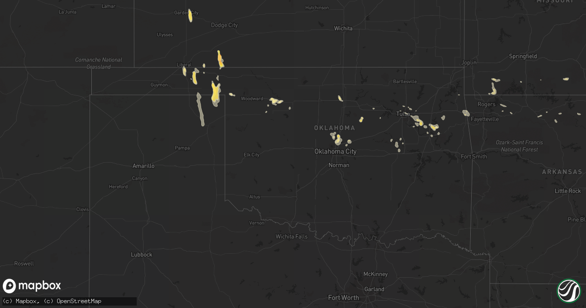
Hail Map in Oklahoma on July 2, 2015
Get this storm
July 2 map
$229
one time, instant access
Download today. No call, no setup
Keep the $229
Bought the map and want the full workflow? Apply the entire $229 to a subscription within 7 days. None of it is wasted.
Every map, not just this one
This buys you this map. Subscription and you get every map we run, in the markets you choose from a few cities to whole states to nationwide. Plus real-time alerts the moment a storm fires.
Contact data
Name, contact info, occupancy, even credit band for addresses in the footprint. You go from where it hit to who to call.
Become the source they trust
Unlimited branding weather history reports on demand. You already have the documented answer ready for the property owner, and you are the one who showed up with it.
Property data and RoofTrace estimates
Pull up any address you have got, its value and the exact code rules for that jurisdiction, straight from One Click Code. Then RoofTrace estimates the squares, pitch, and roof value, priced the way you price.
Storm reports in Oklahoma
Oklahoma
| Date | Description |
|---|---|
| 07/02/20156:43 PM CDT | Numerous tree limbs down. 11th and garnett area. |
| 07/02/20156:41 PM CDT | Several large tree limbs down. |
| 07/02/20156:24 PM CDT | Tree limbs blown down and a dead tree blown over near the clear lake area. |
| 07/02/20156:00 PM CDT | Several high line power poles downed on north-south road 153 a few miles south of highway 412. |
| 07/02/20156:00 PM CDT | Several high line power poles downed on north-south road 153 a few miles south of highway 412. |
| 07/02/20156:00 PM CDT | South of midway church...trees of 8 to 12 inch diamter were downed and a power pole was broken. |
| 07/02/20155:55 PM CDT | Additional gust of 67 mph at 600 pm. Via ok mesonet. |
| 07/02/20155:33 PM CDT | Tree limbs blown down and a dead tree blown over near the clear lake area. |
| 07/02/20155:05 PM CDT | 2-4 in. Tree limbs down on hwy 108. |
All States Impacted by Hail Map on July 2, 2015
Cities Impacted by Hail Map on July 2, 2015
- Mancos, CO
- Turpin, OK
- Geneva, NE
- Shickley, NE
- Sutton, NE
- Manhattan, KS
- Fowler, KS
- Meade, KS
- Frankford, DE
- Selbyville, DE
- Cimarron, NM
- Perry, OK
- Jemez Springs, NM
- Ravenden, AR
- Mountain Rest, SC
- Walhalla, SC
- Westminster, SC
- Grants, NM
- Nakina, NC
- Cochran, GA
- Hawkinsville, GA
- Sapello, NM
- Loris, SC
- Garden City, KS
- Coweta, OK
- Porter, OK
- Broken Arrow, OK
- Wagoner, OK
- Tulsa, OK
- Hollywood, AL
- Scottsboro, AL
- Willcox, AZ
- La Crosse, KS
- Bison, KS
- Rockledge, FL
- Merritt Island, FL
- Melbourne, FL
- Cocoa, FL
- Chester, OK
- Silver City, NM
- Glendale, UT
- Russell, KS
- Waldo, KS
- Paradise, KS
- Davenport, NE
- Cleveland, NM
- Bellemont, AZ
- Nicholson, GA
- Colbert, GA
- Athens, GA
- Hull, GA
- Stevenson, AL
- York, NE
- Bradshaw, NE
- Polk, NE
- Henderson, NE
- Billings, OK
- Siloam Springs, AR
- Lithia, FL
- Roswell, NM
- Venus, FL
- Perryton, TX
- Howard, CO
- Greenway, AR
- Piggott, AR
- Rector, AR
- Burke, SD
- Reading, KS
- Luther, OK
- Edmond, OK
- Laurel Hill, FL
- Laramie, WY
- Sardis, GA
- Aynor, SC
- Conway, SC
- Galivants Ferry, SC
- Tijeras, NM
- Guthrie, OK
- Englewood, KS
- Plains, KS
- Hulbert, OK
- Dozier, AL
- Brantley, AL
- Eastman, GA
- Metter, GA
- Register, GA
- Owasso, OK
- Douglas, AZ
- Forgan, OK
- Maramec, OK
- Cleveland, OK
- Harriet, AR
- Marshall, AR
- Keysville, GA
- Waynesboro, GA
- Louisville, GA
- Cuba, KS
- Belleville, KS
- Agenda, KS
- Gate, OK
- Supai, AZ
- Beaver, OK
- Mcville, ND
- Pekin, ND
- Calhoun, GA
- Dora, MO
- Brixey, MO
- Flippin, AR
- Mountain Home, AR
- Henryetta, OK
- Okmulgee, OK
- Saint Marys, GA
- Kings Bay, GA
- Kingsland, GA
- Yulee, FL
- Aurora, KS
- East Dublin, GA
- Pittsview, AL
- Panhandle, TX
- Jay, OK
- Booker, TX
- Canadian, TX
- Virginia Beach, VA
- Laurens, SC
- Watts, OK
- Colcord, OK
- Dolores, CO
- Fort Myers, FL
- Lehigh Acres, FL
- Portal, GA
- Clinton, KY
- Claremore, OK
- Buena Vista, NM
- Pitts, GA
- Cordele, GA
- Miami, TX
- Orderville, UT
- Elida, NM
- Portales, NM
- Pep, NM
- Paragould, AR
- Natoma, KS
- Rawlins, WY
- Abilene, KS
- Estancia, NM
- Ripley, OK
- Perkins, OK
- Stillwater, OK
- Shattuck, OK
- Fort Gibson, OK
- Claude, TX
- Reynolds, GA
- North Fort Myers, FL
- Punta Gorda, FL
- Sugar Valley, GA
- Pie Town, NM
- Cassville, MO
- Exeter, MO
- Seligman, MO
- Washburn, MO
- Clay Center, KS
- Laverne, OK
- Forest River, ND
- Follett, TX
- Miltonvale, KS
- Minneapolis, KS
- Fairview, OK
- Weleetka, OK
- Chesapeake, VA
- Abbeville, GA
- Hebron, NE
- Deshler, NE
- Hope, KS
- Muskogee, OK
- Huntsville, AR
- Berryville, AR
- Walnut Ridge, AR
- Bono, AR
- Adrian, GA
- Swainsboro, GA
- Mutual, OK
- Eureka Springs, AR
- Medina, TN
- Humboldt, TN
- Pelham, GA
- New Concord, KY
- Cotopaxi, CO
- Durango, CO
- Purdy, MO
- Butterfield, MO
- Buford, WY
- Tie Siding, WY
- Valrico, FL
- Bradleyville, MO
- Cross, SC
- Wellington, TX
- Shamrock, TX
- Danielsville, GA
- Everton, AR
- Western Grove, AR
- Arcadia, FL
- Belton, SC
- Torreon, NM
- Labelle, FL
- Moore Haven, FL
- Great Bend, KS
- Scandia, KS
- Tompkinsville, KY
- Mount Hermon, KY
- Alicia, AR
- Crestview, FL
- Hephzibah, GA
- Blythe, GA
- Lincolnton, GA
- Lake City, FL
- Lake Placid, FL
- Cuba, NM
- Baker, FL
- Pierceville, KS
- Kathleen, GA
- Bonaire, GA
- Fort Valley, GA
- Perry, GA
- Warner Robins, GA
- Quail, TX
- Mooreland, OK
- Brookland, AR
- Lake City, AR
- Littlefield, AZ
- Oklahoma City, OK
- Arcadia, OK
- Fackler, AL
- Westcliffe, CO
- Trenton, AL
- Woodville, AL
- Monette, AR
- Leachville, AR
- Bluewater, NM
- Jennings, OK
- Towaoc, CO
- Waterloo, SC
- Smithville, AR
- Lynn, AR
- Hampton, NE
- Hordville, NE
- Solomon, KS
- Rochelle, GA
- Hugoton, KS
- Tuckerman, AR
- Newport, AR
- Lakemont, GA
- Munden, KS
- Sylvester, GA
- Strawberry, AR
- Dublin, GA
- Cashion, OK
- Balko, OK
- Kingstree, SC
- Commerce, GA
- Estero, FL
- Brockwell, AR
- Pineville, AR
- Calico Rock, AR
- Salida, CO
- Bristow, OK
- Clarendon, TX
- Loxahatchee, FL
- Jones, OK
- Higdon, AL
- Flat Rock, AL
- Ocate, NM
- Yellville, AR
- Sandia Park, NM
- Ridgeville, SC
- Jonesboro, AR
- Alma, KS
- Hemingway, SC
- Berlin, MD
- Ocean City, MD
- Reeds Spring, MO
- Admire, KS
- Clifton, AZ
- Morenci, AZ
- Pawnee Rock, KS
- Mchenry, ND
- Soperton, GA
- Tarrytown, GA
- Naples, FL
- Datil, NM
- Bayfield, CO
- Willacoochee, GA
- Wray, GA
- Long Creek, SC
- Fargo, OK
- Lenora, KS
- Sperry, OK
- Rush Center, KS
- Wrightsville, GA
- Bonita Springs, FL
- Nekoma, KS
- Arnoldsville, GA
- Crawford, GA
- Blanding, UT
- Hays, KS
- Davisboro, GA
- Hoisington, KS
- Smithfield, NC
- Selma, NC
- Defuniak Springs, FL
- Longford, KS
- Hardy, AR
- Williford, AR
- Appling, GA
- Anderson, SC
- Claxton, GA
- Collins, GA
- Cobbtown, GA
- Hawthorne, FL
- Locust Grove, OK
- Peggs, OK
- Jewell, KS
- Black Rock, AR
- Larned, KS
- Center, CO
- Saguache, CO


