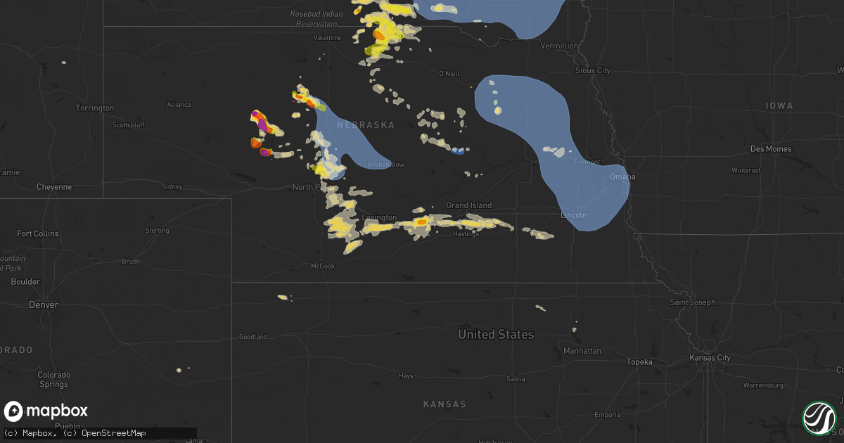
Hail Map on July 15, 2025
Get this storm
July 15 map
$229
one time, instant access
Download today. No call, no setup
Keep the $229
Bought the map and want the full workflow? Apply the entire $229 to a subscription within 7 days. None of it is wasted.
Every map, not just this one
This buys you this map. Subscription and you get every map we run, in the markets you choose from a few cities to whole states to nationwide. Plus real-time alerts the moment a storm fires.
Contact data
Name, contact info, occupancy, even credit band for addresses in the footprint. You go from where it hit to who to call.
Become the source they trust
Unlimited branding weather history reports on demand. You already have the documented answer ready for the property owner, and you are the one who showed up with it.
Property data and RoofTrace estimates
Pull up any address you have got, its value and the exact code rules for that jurisdiction, straight from One Click Code. Then RoofTrace estimates the squares, pitch, and roof value, priced the way you price.
States Impacted by Hail Map on July 15, 2025
Storm reports
Georgia
| Date | Description |
|---|---|
| 07/15/20255:30 PM CDT | Tree reported down on a home on the 100 block of halls bridge rd. |
| 07/15/20255:30 PM CDT | Tree reported down through the roof of a home on harper st. |
| 07/15/20255:24 PM CDT | Multiple trees and power lines reported down... Blocking the road on scout island rd near jackson lake. |
| 07/15/20254:15 PM CDT | Em reports a few trees down and power out along hollondville rd just north of the intersection with reidsboro rd. |
Alabama
| Date | Description |
|---|---|
| 07/15/20255:30 PM CDT | Social media report of trees down on westmont street. |
| 07/15/20255:26 PM CDT | Geneva county 911 reports numerous trees and power lines down across geneva. |
| 07/15/20255:24 PM CDT | Social media report of a tree down at the corner of twin rivers and mcdougald street in eunola. |
| 07/15/20255:16 PM CDT | Social media photo of power lines down in the oak grove area from the wiregrass electric cooperative. |
| 07/15/20255:09 PM CDT | Tree down on power line in the highland park area. |
| 07/15/20254:39 PM CDT | Dale county 911 reports a power line down near hwy 27 and county rd 39. |
Idaho
| Date | Description |
|---|---|
| 07/15/20256:39 PM CDT | Mesonet station mofi1 moburg canyon. |
| 07/15/20256:15 PM CDT | Mesonet station 3004 d4 juniper interchange i-84. |
| 07/15/20255:25 PM CDT | Lightning struck a power pole at 4100 east 1400 north and started a fire that was later extinguished from the rain. Power outages for the majority of the county south f |
| 07/15/20254:30 PM CDT | Mesonet station 3699 d6 inl puzzle us-20/us-26. |
| 07/15/20254:15 PM CDT | Greenhouse demolished. |
| 07/15/20254:01 PM CDT | Knocked branches out of my trees and ripped the trop rail off my fence. Blew deck furniture over. Power outage. |
| 07/15/20253:45 PM CDT | Grace agrimet. |
| 07/15/20253:45 PM CDT | Mesonet station grei 1 nw niter. |
| 07/15/20253:40 PM CDT | Mesonet station pc371 medicine lodge. |
| 07/15/20253:40 PM CDT | Pacficorp medicine lodge. |
| 07/14/20258:15 PM CDT | Mesonet station 3673 d6 antelope flats us-26. |
| 07/14/20257:45 PM CDT | Mesonet station grai1 grace. |
| 07/14/20257:40 PM CDT | Photo of a large treen blown over onto fence via social media. |
| 07/14/20257:35 PM CDT | Idaho power reports over 1000 customers without power across the south end of pocatello. Time estimated by radar. Numerous wind gusts observed in the 45-55 mph range ac |
| 07/14/20257:35 PM CDT | Mesonet station for 2 e fort hall. |
| 07/14/20257:30 PM CDT | Trained spotter relayed reports of downed power lines on philbin rd in chubbuck. |
| 07/14/20257:25 PM CDT | Photo of very top of large evergreen tree snapped off and report of other branches down in the area. Shared via social media. |
| 07/14/20257:15 PM CDT | Mesonet station 5647 d5 mccammon interchange i-15. |
| 07/14/20257:00 PM CDT | Mesonet station 8833 d5 swan lake us-91. |
| 07/14/20257:00 PM CDT | Mesonet station 3010 d5 malad summit i-15. |
| 07/14/20257:00 PM CDT | Mesonet station pc497 station canyon. |
Oklahoma
| Date | Description |
|---|---|
| 07/14/20259:28 PM CDT | Report from mping: quarter |
| 07/14/20257:20 PM CDT | Burneyville mesonet. |
Utah
| Date | Description |
|---|---|
| 07/15/20256:40 PM CDT | Measured wind gust of 61 mph at baccus/sr111 mesonet sensor |
| 07/15/20255:10 PM CDT | Measured wind gust of 63 mph at us-6 at mp 296 sphinx siding mesonet sensor |
| 07/15/20254:50 PM CDT | Measured wind gust of 63 mph at salt flats mesonet sensor |
| 07/15/20254:44 PM CDT | Asos station kvel vernal rgnl airport. Convective outflow wind from distant thunderstorms. |
| 07/15/20259:10 AM CDT | Mesonet station utncc i-15 at mp 62 n cedar city. Likely a dry microburst from a low-reflectivity shower moving over the site. |
| 07/14/20257:00 PM CDT | Measured wind gust of 66 mph at i-15 @ mp 169 mesonet station |
| 07/14/20257:00 PM CDT | Measured wind gust of 58 mph at sr-30 @ curlew mesonet sensor |
Kentucky
| Date | Description |
|---|---|
| 07/14/20259:15 PM CDT | Ham radio operator passed on a report of a large downed tree at 10:15 pm in allen... Floyd county. |
Nevada
| Date | Description |
|---|---|
| 07/15/20255:53 PM CDT | Station |
| 07/15/20255:15 PM CDT | 4-5 inch tree limbs downed and nearby hay barn with metal roof peeled back. Time estimated from radar. |
| 07/15/20254:26 PM CDT | Station crane springs raws... Elevation 6414 ft. |
| 07/15/20253:39 PM CDT | Station moor raws... Elevation 6121 ft. |
| 07/14/20258:32 PM CDT | A local report indicates 73 MPH wind near 10 ENE Wells |
Minnesota
| Date | Description |
|---|---|
| 07/15/20254:28 PM CDT | Delayed lsr - report from sheriffs dispatch of a tree down along a road in becker township. Time estimated via radar. |
| 07/15/20254:15 PM CDT | Delayed report. Time estimated via radar. Substantial tree damage with snapped trees and debris in road. |
| 07/15/20254:15 PM CDT | Delayed report. Time estimated from radar. Snapped trees on county rd 16 off hwy 10. |
| 07/15/20254:15 PM CDT | Delayed report of large branch snapped off a willow tree near darling township. Photo shared via facebook. Time estimated from radar. |
| 07/15/20254:12 PM CDT | Public report of trees down near us10 south of motley. Relayed via county dispatch. |
| 07/15/20254:09 PM CDT | Corrects previous tstm wnd dmg report from 4 nne nemadji. Multiple trees and a flagpole were downed at the reporters location. Time estimated by radar. |
| 07/15/20254:00 PM CDT | Delayed report. Many trees damaged and stripped of leaves. |
| 07/15/20253:59 PM CDT | Delayed lsr - photo or large tree branches snapped 4 miles south of luxemburg. |
| 07/15/20253:09 PM CDT | Corrects previous tstm wnd dmg report from 4 nne nemadji. Corrects previous tstm wnd dmg report from 4 nne nemadji. Multiple trees and a flagpole were downed at the rep |
| 07/15/20253:09 PM CDT | Multiple trees and a flagpole were downed at the reporters location. Time estimated by radar. |
| 07/15/20252:53 PM CDT | Asos station kaxn alexandria mn asos. |
| 07/15/20258:25 AM CDT | Report via social media with photo. |
| 07/15/20258:21 AM CDT | Report via social media. Time estimated from radar. |
| 07/15/20258:20 AM CDT | A local report indicates 1.00 inch wind near 2 W Finlayson |
North Carolina
| Date | Description |
|---|---|
| 07/15/20253:55 PM CDT | Trees down near the intersection of reedy fork parkway and eckerson road. |
| 07/14/20258:19 PM CDT | Tree down across road near intersection of old us 52 s and farm wy. |
| 07/14/20258:07 PM CDT | One tree down on s andy griffith pkwy near rockford st. |
| 07/14/20257:38 PM CDT | Tree down near the intersection of haystack road and thurmond road. |
Nebraska
| Date | Description |
|---|---|
| 07/15/20256:34 PM CDT | Pws-knedunni2. |
| 07/15/20255:57 PM CDT | A local report indicates 1.00 inch wind near 10 S Springview |
| 07/15/20255:57 PM CDT | A local report indicates 1.00 inch wind near 10 S Springview |
| 07/15/20255:49 PM CDT | A local report indicates 1.00 inch wind near 6 S Springview |
| 07/15/20255:30 PM CDT | A local report indicates 1.50 inch wind near 5 N Springview |
| 07/15/20255:19 PM CDT | Report from mping. |
| 07/15/20255:14 PM CDT | Report from mping. |
| 07/15/20254:28 PM CDT | A local report indicates 2.00 inch wind near 3 E Hyannis |
| 07/15/202511:52 AM CDT | 8 inch diameter tree down near 103rd and blair high road. |
| 07/15/20251:15 AM CDT | Received photo via facebook of hail up to around ping pong ball size. |
| 07/15/20251:15 AM CDT | Hail up to around quarter size reported in kearney. |
| 07/15/202512:35 AM CDT | Reports of mostly dime to nickel size in kearney... Isolated quarter size. |
| 07/15/202512:01 AM CDT | Personal weather station. |
| 07/15/202512:00 AM CDT | Powerlines |
| 07/15/202512:00 AM CDT | Powerli |
| 07/15/202512:00 AM CDT | Powerlines down. |
| 07/14/202511:52 PM CDT | Corrects time of previous tstm wnd dmg report from 5 nw omaha. 8 inch diameter tree down near 103rd and blair high road |
| 07/14/202511:52 PM CDT | Corrects time of previous tstm wnd dmg report from 5 nw omaha. 8 inch diameter tree down near 103rd and blair high road. |
| 07/14/202511:47 PM CDT | Personal weather station. |
| 07/14/202511:47 PM CDT | Personal weather station. |
| 07/14/202511:41 PM CDT | Personal weather station. |
| 07/14/202511:37 PM CDT | Personal weather station. |
| 07/14/202511:35 PM CDT | A local report indicates 64 MPH wind near 4 WNW Lincoln |
| 07/14/202511:35 PM CDT | A local report indicates 62 MPH wind near 2 NE Wahoo |
| 07/14/202511:32 PM CDT | A local report indicates 65 MPH wind near 2 S Wahoo |
| 07/14/202510:53 PM CDT | A local report indicates 65 MPH wind near 2 NW Brainard |
| 07/14/202510:49 PM CDT | A local report indicates 60 MPH wind near 2 N Abie |
| 07/14/202510:22 PM CDT | Several trees uprooted and branches broken. |
| 07/14/20259:20 PM CDT | A local report indicates 60 MPH wind near Greeley |
| 07/14/20257:38 PM CDT | A local report indicates 1.00 inch wind near 13 SW Stapleton |
| 07/14/20257:34 PM CDT | Reports of 64 mph wind with large tree branches down. |
Florida
| Date | Description |
|---|---|
| 07/15/20255:56 PM CDT | Tree down on a power line impacting 780 customers. |
| 07/15/20254:43 PM CDT | Social media report of quarter size hail in the greenhead area. |
| 07/15/20254:25 PM CDT | Washington county reports trees down in the area of clayton rd. |
South Dakota
| Date | Description |
|---|---|
| 07/15/20256:28 PM CDT | Personal weather station. |
| 07/15/20256:25 PM CDT | Mesonet station 304 sd rwis corsica. |
| 07/15/20256:25 PM CDT | Personal weather station. |
| 07/15/20256:25 PM CDT | Personal weather station. |
| 07/15/20256:20 PM CDT | Mesonet station 304 sd rwis corsica. |
| 07/15/20256:20 PM CDT | Personal weather station. |
| 07/15/20256:11 PM CDT | Damage across town included uprooted tree... Roof and siding damage from flying debris... Damage to metal barn and a bent street sign. |
| 07/15/20256:08 PM CDT | Mesonet station 244 sd rwis ft. Randall dam. |
| 07/15/20256:08 PM CDT | A local report indicates 1.00 inch wind near 4 W De Smet |
| 07/15/20256:05 PM CDT | Personal weather station. |
| 07/15/20255:55 PM CDT | A local report indicates 60 MPH wind near Bonesteel |
| 07/15/20255:46 PM CDT | Mesonet station rlas2 lake andes raws. |
| 07/15/20255:32 PM CDT | Personal weather station. |
| 07/15/20255:17 PM CDT | Personal weather station. |
| 07/15/20255:01 PM CDT | In addition to hail up to half dollar size... Heavy rain and 40-50 mph wind gusts stripped some leaves from trees. |
| 07/15/20254:42 PM CDT | Mesonet station 283 sd rwis dixon. |
| 07/15/20254:38 PM CDT | A local report indicates 1.00 inch wind near 3 NNE Wewela |
| 07/15/20254:35 PM CDT | In addition to a few quarter sized hail stones... Rainfall was about 0.30 to 0.40 inch. |
| 07/15/20254:09 PM CDT | A local report indicates 1.50 inch wind near 2 W Clearfield |
| 07/15/20254:03 PM CDT | A local report indicates 1.00 inch wind near 5 SSE Winner |
| 07/14/20258:48 PM CDT | Personal weather station. |
| 07/14/20258:45 PM CDT | Via personal weather station. |
| 07/14/20258:35 PM CDT | Wind gusts estimated at 60-65 mph knocked a couple trees down. Heavy rain followed... Reducing visibility to about 100 feet . |
| 07/14/20258:22 PM CDT | Mesonet station 18 sd rwis montrose. |
| 07/14/20257:42 PM CDT | Mesonet station 163 sd rwis freeman. Initial severe gust at 742 pm with a peak gust of 61 mph at 744 pm. |
| 07/14/20257:38 PM CDT | Tree down blocking the road near 3rd and cherry. Via social media. |
| 07/14/20257:36 PM CDT | Measured by personal weather station. First severe gust at 736 pm at 61 mph... And 66 mph at 741 pm. |
| 07/14/20257:25 PM CDT | Mesonet station 297 sd rwis howard. |
| 07/14/20257:07 PM CDT | Strong wind gusts pushed through town... Breaking many tree branches... Blowing out a grain bin... And registering about 53 mph at the airport. |
| 07/14/20257:06 PM CDT | Personal weather station. |
Virginia
| Date | Description |
|---|---|
| 07/15/20256:58 PM CDT | Tree across power dam road blocking one lane of traffic. |
| 07/15/20254:12 PM CDT | Damage to roof and a greenhouse reported. |
| 07/15/20252:38 PM CDT | Report of a downed tree on elm road. |
Kansas
| Date | Description |
|---|---|
| 07/15/20251:18 AM CDT | Kcnk. |
Wyoming
| Date | Description |
|---|---|
| 07/15/20256:08 PM CDT | Mesonet station kbit point of rocks 10.4 e |
| 07/15/20255:20 PM CDT | Mesonet station pc452 cottonwood merna. |
| 07/15/20254:57 PM CDT | Mesonet station elkw4 elkhorn. |
| 07/15/20254:53 PM CDT | Corrects previous non-tstm wnd gst report from 2 n marbleton. Asos station kbpi big piney airport. |
| 07/15/20254:30 PM CDT | A local report indicates 61 MPH wind near Dubois |
| 07/15/20253:09 PM CDT | Mesonet station up098 sage junction 2.7 e |
| 07/15/202511:40 AM CDT | Mesonet station pc450 evanston north. Likely dry microburst associated with a weak line of showers. |
| 07/15/202511:35 AM CDT | Mesonet station av868 medicine butte mountain. Likely dry microburst associated with a weak line of showers. |
| 07/14/20258:50 PM CDT | Mesonet station camw4 muddy gap 7 sw. |
| 07/14/20258:15 PM CDT | Corrects previous non-tstm wnd gst report from 13 s thermopolis. Awos station ktbx boysen peak. |
Wisconsin
| Date | Description |
|---|---|
| 07/15/20256:42 PM CDT | Tree on powerline and on fire. Time estimated from radar. |
| 07/15/20256:22 PM CDT | 18 inch diameter pine tree snapped 6 feet off the ground based on photo. Time estimated by radar. |
| 07/15/20255:55 PM CDT | Trees down all along county highway f between county highway k and highway 53. Facebook report. |
| 07/15/20255:15 PM CDT | Trees down on roadway. Time estimated from radar. |
| 07/15/20253:05 PM CDT | 11 trees down across bad river reservation roadways that had to be removed by road crews. Time and location estimated. |
| 07/15/20252:55 PM CDT | A photo was received showing a tree down in ashland. Time estimated by radar. |
| 07/15/20252:20 PM CDT | Three large trees down along scenic drive. |
| 07/14/20258:41 PM CDT | Trees and power lines down. Time estimated by radar. |
| 07/14/20258:20 PM CDT | Trees and power lines down. |
| 07/14/20257:15 PM CDT | Trees on road. Time estimated from radar. |
Cities Impacted by Hail Map on July 15, 2025
- Odonnell, TX
- Lamesa, TX
- Onamia, MN
- McGrath, MN
- Isle, MN
- Wahkon, MN
- Finlayson, MN
- Hayward, WI
- Askov, MN
- Barnum, MN
- Moose Lake, MN
- Carlton, MN
- Superior, WI
- Wrenshall, MN
- Kerrick, MN
- Holyoke, MN
- Foxboro, WI
- South Range, WI
- Solon Springs, WI
- Willow River, MN
- Lake Nebagamon, WI
- Bristol, FL
- Sandstone, MN
- Brule, WI
- Iron River, WI
- Hoffman, MN
- Mass City, MI
- Nisula, MI
- Aberdeen, SD
- Mansfield, SD
- Kensington, MN
- Trout Creek, MI
- Bruce Crossing, MI
- Cresbard, SD
- Evansville, MN
- Brandon, MN
- Ipswich, SD
- Kettle River, MN
- Lanse, MI
- Port Saint Joe, FL
- Pelkie, MI
- Alexandria, MN
- Cloquet, MN
- Edgemont, SD
- Ashland, WI
- Parkers Prairie, MN
- Skanee, MI
- Garfield, MN
- Miltona, MN
- Winner, SD
- Montevideo, MN
- Granite Falls, MN
- Saxon, WI
- Panama City, FL
- Bertha, MN
- Hewitt, MN
- Gordon, WI
- Eden Valley, MN
- Watkins, MN
- Ironwood, MI
- Cromwell, MN
- Sawyer, MN
- McLeansville, NC
- Youngstown, FL
- Litchfield, MN
- Mason, WI
- Maynard, MN
- Sacred Heart, MN
- Custer, SD
- Chiefland, FL
- Ideal, SD
- Hamill, SD
- Wood River, IL
- Lynn Haven, FL
- Colome, SD
- Valentine, NE
- Hyannis, NE
- Two Harbors, MN
- Westlake, LA
- Gregory, SD
- Whitman, NE
- Saint Cloud, MN
- Clear Lake, MN
- Clearwater, MN
- Clara City, MN
- Chamberlain, SD
- Roxana, IL
- Edwardsville, IL
- South Roxana, IL
- Griffin, GA
- Dallas, SD
- Panama City Beach, FL
- Ashford, AL
- Pukwana, SD
- Trego, WI
- Chipley, FL
- Saint Anthony, ID
- Parker, ID
- Sturgeon Lake, MN
- Princeton, MN
- Foley, MN
- Burke, SD
- Hill City, SD
- Rexburg, ID
- Fort Thompson, SD
- Danbury, WI
- Spooner, WI
- Minong, WI
- Webster, WI
- Cambridge, MN
- Vernon, FL
- Williamson, GA
- Seneca, NE
- Thedford, NE
- Springview, NE
- Crowheart, WY
- Braham, MN
- Stanchfield, MN
- Cusseta, GA
- Daleville, AL
- Mills, NE
- Platte, SD
- Heber, AZ
- Newcastle, WY
- Isanti, MN
- Hinckley, MN
- Show Low, AZ
- Hartford, AL
- Tulare, SD
- Saint Lawrence, SD
- White Lake, SD
- Grandy, MN
- Rush City, MN
- Harris, MN
- Herrick, SD
- Mullen, NE
- Dayton, MN
- Anoka, MN
- Arthur, NE
- Riverton, WY
- Ainsworth, NE
- Bonesteel, SD
- Saint Charles, SD
- Fairfax, SD
- Geddes, SD
- Kimball, SD
- Long Pine, NE
- Bassett, NE
- Iroquois, SD
- De Smet, SD
- Tryon, NE
- Johnstown, NE
- Andover, MN
- Redfield, SD
- Patagonia, AZ
- Fort Washakie, WY
- Lander, WY
- Waconia, MN
- Cologne, MN
- Lake Andes, SD
- Armour, SD
- Corsica, SD
- Harrison, SD
- New Holland, SD
- Wagner, SD
- Osseo, MN
- Champlin, MN
- Frederic, WI
- Statesville, NC
- Woonsocket, SD
- Shell Lake, WI
- Naper, NE
- Minneapolis, MN
- Stickney, SD
- Plankinton, SD
- Springbrook, WI
- Fort Walton Beach, FL
- Shalimar, FL
- Hertel, WI
- Ashton, SD
- Midway, AL
- Clayton, AL
- Andover, SD
- Stuart, NE
- Chaska, MN
- Victoria, MN
- Pickstown, SD
- Union Springs, AL
- Alvord, TX
- Sunset, TX
- Louisville, AL
- Hudson, WY
- Fedora, SD
- Artesian, SD
- Carthage, SD
- Sutherland, NE
- Bryant, SD
- Willow Lake, SD
- Stapleton, NE
- Atkinson, NE
- Howard, SD
- Halsey, NE
- Arnold, NE
- Purdum, NE
- Dunning, NE
- Anselmo, NE
- Winter, WI
- Dante, SD
- Lake Preston, SD
- Forestburg, TX
- Banks, AL
- Mount Vernon, SD
- Parkston, SD
- Ethan, SD
- Dimock, SD
- Mitchell, SD
- Delmont, SD
- Avon, SD
- Tripp, SD
- Jeffrey City, WY
- Park Falls, WI
- Butternut, WI
- Mellen, WI
- Clam Lake, WI
- Cable, WI
- Marengo, WI
- Merna, NE
- Broken Bow, NE
- Callaway, NE
- Brady, NE
- Glidden, WI
- Lytle, TX
- Poteet, TX
- Somerset, TX
- Alexandria, SD
- Tyndall, SD
- Freeman, SD
- Kaylor, SD
- Emery, SD
- Scotland, SD
- Menno, SD
- Olivet, SD
- Lesterville, SD
- Bridgewater, SD
- Spencer, SD
- Fulton, SD
- Salem, SD
- Canova, SD
- Wilson, OK
- Ardmore, OK
- Gothenburg, NE
- Maxwell, NE
- North Platte, NE
- Wolsey, SD
- Hitchcock, SD
- Troy, AL
- Kit Carson, CO
- Casper, WY
- Mercer, WI
- Yankton, SD
- Irene, SD
- Utica, SD
- Tabor, SD
- Crofton, NE
- Saint Helena, NE
- Mission Hill, SD
- Marion, SD
- Viborg, SD
- Canistota, SD
- Montrose, SD
- Marenisco, MI
- Gainesville, TX
- Volin, SD
- Humboldt, SD
- Hurley, SD
- Monroe, SD
- Davis, SD
- Centerville, SD
- Parker, SD
- Chancellor, SD
- Wakonda, SD
- Gayville, SD
- Vermillion, SD
- Lennox, SD
- Hartford, SD
- Rawlins, WY
- Star, NC
- Shoshoni, WY
- Thermopolis, WY
- Manitowish Waters, WI
- Presque Isle, WI
- Boulder Junction, WI
- Sioux Falls, SD
- Harrisburg, SD
- Tea, SD
- Worthing, SD
- Pierce, NE
- Tilden, NE
- Orchard, NE
- Brunswick, NE
- Petersburg, NE
- Clearwater, NE
- Elgin, NE
- Plainview, NE
- Royal, NE
- Oakdale, NE
- Neligh, NE
- Osmond, NE
- Ewing, NE
- Meadow Grove, NE
- Ansley, NE
- Saint Jo, TX
- Burwell, NE
- Seagrove, NC
- Land O'Lakes, WI
- Canton, SD
- Crooks, SD
- Renner, SD
- Hoskins, NE
- Carroll, NE
- Winside, NE
- Randolph, NE
- Norfolk, NE
- Wayne, NE
- Belden, NE
- Mclean, NE
- Watersmeet, MI
- Brandon, SD
- Larchwood, IA
- Madison, NE
- Battle Creek, NE
- Hurley, WI
- Roberts, ID
- Hanna, WY
- Ada, OK
- Elyria, NE
- McDonald, KS
- Chambers, NE
- Ewen, MI
- Pilger, NE
- Wakefield, NE
- Pender, NE
- Wisner, NE
- Stanton, NE
- Newman Grove, NE
- Wausa, NE
- Creighton, NE
- Greeley, NE
- Ord, NE
- Bartlett, NE
- Ericson, NE
- Farnam, NE
- Moorefield, NE
- Curtis, NE
- Maywood, NE
- Maricopa, AZ
- Scotia, NE
- Konawa, OK
- Valley Springs, SD
- Garretson, SD
- Beaver Creek, MN
- Eustis, NE
- Sells, AZ
- Cozad, NE
- Spalding, NE
- Stockville, NE
- Wellfleet, NE
- Lindsay, NE
- Leigh, NE
- Humphrey, NE
- Lava Hot Springs, ID
- Snowville, UT
- Grace, ID
- Mccammon, ID
- Holbrook, ID
- Malad City, ID
- Downey, ID
- Arimo, ID
- Saint Paul, NE
- Elwood, NE
- Wolbach, NE
- Oconto, NE
- Big Piney, WY
- Daniel, WY
- Rock Springs, WY
- Wamsutter, WY
- Dubois, WY
- Bartley, NE
- Palmer, NE
- Ririe, ID
- Swan Valley, ID
- Malta, ID
- Park Valley, UT
- Howells, NE
- Clarkson, NE
- Beemer, NE
- Creston, NE
- Bancroft, NE
- West Point, NE
- Dodge, NE
- Schuyler, NE
- Burneyville, OK
- Holbrook, NE
- Snyder, NE
- Rogers, NE
- North Bend, NE
- Scribner, NE
- Laurel, NE
- Axtell, NE
- Lexington, NE
- Linwood, NE
- Bellwood, NE
- Columbus, NE
- David City, NE
- Kearney, NE
- Minden, NE
- Brainard, NE
- Bruno, NE
- Prague, NE
- Morse Bluff, NE
- Abie, NE
- Smithfield, NE
- Bertrand, NE
- Weston, NE
- Wahoo, NE
- Cedar Bluffs, NE
- Malmo, NE
- Colon, NE
- Ceresco, NE
- Valparaiso, NE
- Fremont, NE
- Ames, NE
- Hooper, NE
- Overton, NE
- Elm Creek, NE
- Dwight, NE
- Bee, NE
- Raymond, NE
- Pleasant Dale, NE
- Malcolm, NE
- Garland, NE
- Lincoln, NE
- Davey, NE
- Ithaca, NE
- Mead, NE
- Yutan, NE
- Ashland, NE
- Waverly, NE
- Roca, NE
- Memphis, NE
- Greenwood, NE
- Waterloo, NE
- Valley, NE
- Murdock, NE
- Omaha, NE
- La Vista, NE
- Springfield, NE
- South Bend, NE
- Louisville, NE
- Walton, NE
- Elkhorn, NE
- Eagle, NE
- Papillion, NE
- Gretna, NE
- Alvo, NE
- Bellevue, NE
- Boys Town, NE
- Funk, NE
- Hills, MN
- Council Bluffs, IA
- Bennington, NE
- Carter Lake, IA
- Hickman, NE
- Elmwood, NE
- Cedar Creek, NE
- Bennet, NE
- Colman, SD
- Wentworth, SD
- Chester, SD
- Odessa, NE
- Winfred, SD
- Colton, SD
- Amherst, NE
- Riverdale, NE
- Pleasanton, NE
- Gibbon, NE
- Shelton, NE
- Unadilla, NE
- Manley, NE
- Adams, NE
- Plattsmouth, NE
- Palmyra, NE
- Avoca, NE
- Weeping Water, NE
- Syracuse, NE
- Murray, NE
- Pacific Junction, IA
- Otoe, NE
- Offutt Afb, NE
- Nehawka, NE
- Fort Calhoun, NE
- Kenesaw, NE
- Wood River, NE
- Heartwell, NE
- Clifton, KS
- Linn, KS
- Casa Grande, AZ
- Denton, NE
- Crescent, IA
- Doniphan, NE
- Trumbull, NE
- Giltner, NE
- Hastings, NE
- Juniata, NE
- Harvard, NE
- Aurora, NE
- Tuskegee, AL
- Olsburg, KS
- Saronville, NE
- Sutton, NE
- Henderson, NE
- Grafton, NE
- Fairmont, NE
- Exeter, NE
- Friend, NE
- Dorchester, NE
- Crete, NE
- Milligan, NE
- Western, NE
- Wilber, NE