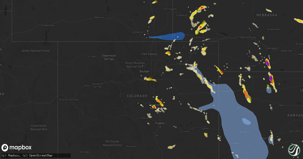
Hail Map on July 6, 2025
Get this storm
July 6 map
$229
one time, instant access
Download today. No call, no setup
Keep the $229
Bought the map and want the full workflow? Apply the entire $229 to a subscription within 7 days. None of it is wasted.
Every map, not just this one
This buys you this map. Subscription and you get every map we run, in the markets you choose from a few cities to whole states to nationwide. Plus real-time alerts the moment a storm fires.
Contact data
Name, contact info, occupancy, even credit band for addresses in the footprint. You go from where it hit to who to call.
Become the source they trust
Unlimited branding weather history reports on demand. You already have the documented answer ready for the property owner, and you are the one who showed up with it.
Property data and RoofTrace estimates
Pull up any address you have got, its value and the exact code rules for that jurisdiction, straight from One Click Code. Then RoofTrace estimates the squares, pitch, and roof value, priced the way you price.
States Impacted by Hail Map on July 6, 2025
Storm reports
Louisiana
| Date | Description |
|---|---|
| 07/06/20254:07 PM CDT | Video of hail falling on a car driving on eraste landry rd. |
| 07/06/20254:02 PM CDT | Scott pd reported golf ball size hail in city limits. |
| 07/06/20254:02 PM CDT | Tree down wilbourn and ambassador. |
Texas
| Date | Description |
|---|---|
| 07/06/20255:10 AM CDT | A local report indicates 59 MPH wind near 2 WSW Clarendon |
| 07/06/20253:00 AM CDT | Pictures from social media of a power pole and multiple large tree branches snapped across the town. |
Oklahoma
| Date | Description |
|---|---|
| 07/06/20253:20 AM CDT | A local report indicates 64 MPH wind near 1 WSW Hooker |
Colorado
| Date | Description |
|---|---|
| 07/06/20256:56 PM CDT | Report from mping: quarter |
| 07/06/20256:51 PM CDT | Report from mping: half dollar |
| 07/06/20256:50 PM CDT | A local report indicates 1.40 inch wind near Black Forest |
| 07/06/20256:50 PM CDT | Report from mping: quarter |
| 07/06/20256:43 PM CDT | A local report indicates 2.00 inch wind near 2 SW Colorado Springs |
| 07/06/20256:40 PM CDT | Report from mping: quarter |
| 07/06/20256:35 PM CDT | A local report indicates 1.50 inch wind near 3 SE Manitou Springs |
| 07/06/20256:34 PM CDT | Report from mping: half dollar |
| 07/06/20256:30 PM CDT | A local report indicates 1.75 inch wind near 3 SE Manitou Springs |
| 07/06/20256:28 PM CDT | Report from mping: quarter |
| 07/06/20256:20 PM CDT | Storm lasted for 40 minutes |
| 07/06/20256:13 PM CDT | Report from mping: half dollar |
| 07/06/20256:07 PM CDT | A local report indicates 1.00 inch wind near 1 SW Colorado Springs |
| 07/06/20256:06 PM CDT | A local report indicates 1.00 inch wind near 1 SE Manitou Springs |
| 07/06/20256:05 PM CDT | A local report indicates 1.00 inch wind near 6 E Monument |
| 07/06/20255:54 PM CDT | Report from mping: ping pong ball |
| 07/06/20254:48 PM CDT | Location estimated. Multiple reports from spotters and chasers with video showing a landspout tornado lasting 5 min in duration. |
| 07/06/20254:40 PM CDT | A local report indicates 1.00 inch wind near 5 N Dailey |
| 07/05/202510:06 PM CDT | Kitr measured 67 mph wind gust. |
| 07/05/20259:29 PM CDT | Mesonet station up729 0.5 w kit carson |
| 07/05/20259:20 PM CDT | Mesonet station krk01 3 e joes 2. |
| 07/05/20258:16 PM CDT | A local report indicates 1.00 inch wind near 1 WNW Aurora |
| 07/05/20257:58 PM CDT | A local report indicates 1.00 inch wind near 4 E Denver |
| 07/05/20257:46 PM CDT | Report from mping: ping pong ball |
| 07/05/20257:39 PM CDT | Awos station kako akron. |
| 07/05/20257:31 PM CDT | Report from mping: quarter |
| 07/05/20257:11 PM CDT | A local report indicates 1.50 inch wind near Falcon |
| 07/05/20257:10 PM CDT | A local report indicates 1.00 inch wind near 3 N Falcon |
| 07/05/20257:07 PM CDT | Report from mping: quarter |
| 07/05/20257:03 PM CDT | A local report indicates 1.00 inch wind near 4 S Colorado Springs |
| 07/05/20257:00 PM CDT | Measured 1.5 inch hail. Widespread window damage and broken skylights reported. Hail fell for approximately 40 consecutive minutes. |
North Carolina
| Date | Description |
|---|---|
| 07/06/20255:13 PM CDT | Tree snapped and fell on a home in the cul-de-sac of casey ln. Other minor tree damage evident on saddle club rd. |
| 07/06/20255:13 PM CDT | Tree snapped and fell on a home in the cul-de-sac of casey ln. Other minor tree d |
| 07/06/20255:11 PM CDT | Multiple trees snapped in the wooded area behind 680 heartpine dr.... On the northwest side of the havenstone subdivision. |
| 07/06/20253:10 PM CDT | Multiple large trees down near high park. Time estimated. |
| 07/06/20252:26 PM CDT | Wncn meteorologist observed multiple trees down... Including at least one large pine snapped... In the 4000 block of moncure pittsboro rd. |
| 07/06/20252:00 PM CDT | Ktta sustained damage to a couple of hangars and aircrafts; and runway and taxiways were closed to remove debris. Krax confirmed tds. |
South Dakota
| Date | Description |
|---|---|
| 07/06/20256:45 PM CDT | A local report indicates 1.00 inch wind near 4 S Dwtn Rapid City |
| 07/06/20256:42 PM CDT | Mping report |
| 07/06/20256:40 PM CDT | A local report indicates 69 MPH wind near 2 ENE Rockerville |
| 07/06/20256:31 PM CDT | A local report indicates 1.00 inch wind near 4 WSW Dwtn Rapid City |
| 07/06/20256:30 PM CDT | A local report indicates 1.75 inch wind near 7 SW Dwtn Rapid City |
| 07/05/20257:11 PM CDT | A local report indicates 1.00 inch wind near Hermosa |
Kansas
| Date | Description |
|---|---|
| 07/06/20256:59 PM CDT | Chaser estimated 60 mph wind gust with near zero visibility in rain. |
| 07/06/20256:35 PM CDT | Kegt. |
| 07/06/20256:34 PM CDT | Delayed report. Reported via mesonet kkscolby59. |
| 07/06/20256:30 PM CDT | Report from mping: quarter |
| 07/06/20255:53 PM CDT | Limbs down. |
| 07/06/20255:49 PM CDT | 50-60 mph. |
| 07/06/20255:48 PM CDT | Site khlc reports 59 mph wind gust. |
| 07/06/20255:29 PM CDT | Estimated 60-65. |
| 07/06/20255:28 PM CDT | Four inch diameter maple branch broken off. |
| 07/06/20255:24 PM CDT | Accuweather meteorologist. |
| 07/06/20255:20 PM CDT | A local report indicates 1.00 inch wind near 5 NNE Blakeman |
| 07/06/20255:14 PM CDT | Estimated 50-60 mph gusts. |
| 07/06/20255:02 PM CDT | Trained spotter reports one inch hail. |
| 07/06/20254:55 PM CDT | A local report indicates 70 MPH wind near 4 SE El Dorado |
| 07/06/20254:50 PM CDT | Numerous limbs reported down in the southeast part of el dorado. |
| 07/06/20254:50 PM CDT | Numerous limbs reported down |
| 07/06/20254:48 PM CDT | Trained spotter reports hail up to 3 inches. Damage to north facing windows. |
| 07/06/20254:40 PM CDT | 6 to 8 inch diameter tree limbs down. |
| 07/06/20254:37 PM CDT | Estimated 60-65 mph. |
| 07/06/20254:35 PM CDT | A local report indicates 66 MPH wind near 4 SE El Dorado |
| 07/06/20254:35 PM CDT | Delayed entry. Text report of golf ball sized hail. |
| 07/06/20254:33 PM CDT | Nickel and quarter sized hail reported. |
| 07/06/20251:00 AM CDT | A local report indicates 69 MPH wind near 2 ENE Garden City |
| 07/06/202512:47 AM CDT | A local report indicates 58 MPH wind near 6 S Deerfield |
| 07/06/202512:41 AM CDT | A local report indicates 62 MPH wind near 4 SW Friend |
| 07/06/202512:40 AM CDT | A local report indicates 66 MPH wind near 3 NE Lakin |
| 07/06/202512:35 AM CDT | A local report indicates 78 MPH wind near 2 E Shallow Water |
| 07/06/202512:01 AM CDT | Ambient weather site leesimons_farms_ reports the gust. |
| 07/05/202511:56 PM CDT | Kansas mesonet site reports the gust. |
| 07/05/202511:54 PM CDT | Kansas mesonet site reports a 60 mph wind gust. |
| 07/05/202511:24 PM CDT | Cw6099. |
| 07/05/202511:15 PM CDT | Kansas mesonet site reports a 2m wind of 59 mph. |
| 07/05/202511:06 PM CDT | Site wallace on ks mesonet measured 59 mph wind gust. |
| 07/05/202510:58 PM CDT | Delayed entry. Ksn storm chaser measured 82 mph wind gust at mm 28 on i-70. |
| 07/05/202510:40 PM CDT | Site kksweska9 measured 72 mph wind gust. |
| 07/05/202510:40 PM CDT | Asos station kgld goodland. |
| 07/05/20259:06 PM CDT | Sizeable tree limb down. |
| 07/05/20259:05 PM CDT | A local report indicates 58 MPH wind near 3 WNW Ford |
| 07/05/20257:14 PM CDT | Very heavy rain and estimated wind gusts to around 60 mph. |
| 07/05/20257:12 PM CDT | Koel measured 62 mph wind gust. |
| 07/05/20257:10 PM CDT | Spotter reports 2 inch green tree limb down in oakley. Time estimated from radar. |
| 07/05/20257:09 PM CDT | Chaser sent in picture of quarter sized hail... 8 miles north of oakley. |
| 07/05/20257:07 PM CDT | Reported via ambient weather station dog_house. |
Illinois
| Date | Description |
|---|---|
| 07/06/20256:32 PM CDT | Swop report. Storm total. |
| 07/06/20255:34 PM CDT | Multiple trees down on power lines. Time estimated from radar. |
| 07/06/20255:05 PM CDT | A brief ef-0 tornado occurred near bingham... Il causing damage to a few farm outbuildings and crops. Video evidence confirmed the tornado. |
| 07/06/20254:40 PM CDT | Large tree down across route 4. |
| 07/06/20254:19 PM CDT | Reports of wires down around collinsville. |
| 07/06/20254:15 PM CDT | Mostly small limbs down and a medium sized branch. Time estimated from radar. |
| 07/06/20254:15 PM CDT | Multiple reports of trees and wires down around caseyville. |
| 07/06/20253:50 PM CDT | Tree down on home. Relayed via broadcast media. |
| 07/06/20252:57 PM CDT | Tree downed onto wires by thunderstorm winds. |
New Mexico
| Date | Description |
|---|---|
| 07/06/20252:35 PM CDT | A local report indicates 1.00 inch wind near 1 SE Sandia Park |
| 07/06/20252:33 PM CDT | Report from mping: quarter |
| 07/06/20252:20 PM CDT | A local report indicates 1.00 inch wind near 4 SE Sandia Park |
Indiana
| Date | Description |
|---|---|
| 07/06/20256:50 PM CDT | Trees down onto powerlines near the intersection of 150 e and 300 s on the south side of logansport. Time estimated via radar. A 47 mph gust was recorded nearby at the |
Michigan
| Date | Description |
|---|---|
| 07/06/20254:20 PM CDT | Multiple trees down on powerlines near intersection of hockaday rd and armchester dr. Report relayed by gladwin county em. Time estimated via radar. |
Montana
| Date | Description |
|---|---|
| 07/05/202510:40 PM CDT | Winds gusted 50 to 60 mph. |
Maine
| Date | Description |
|---|---|
| 07/06/20256:58 PM CDT | Tree on power lines on exeter road. |
| 07/06/20256:27 PM CDT | Tree down in road on old town road... Near rogers market. |
| 07/06/20256:22 PM CDT | Burning tree on wires at pinkham drive and darling road in hudson. |
| 07/06/20256:21 PM CDT | Lightning strike. Tree fell on vehicle and down on exeter road with wires down. |
| 07/06/20256:19 PM CDT | Tree down... No power lines involved. |
| 07/06/20255:48 PM CDT | Corrects previous lightning report from 3 ne danforth. Report on social media of lakeside homes and camps with trees down on or around them on east grand lake. Time est |
| 07/05/20257:03 PM CDT | Low hanging wires and trees down on greenfield road. |
Nebraska
| Date | Description |
|---|---|
| 07/06/20256:53 PM CDT | Upr site near brownson gusted 58 mph during a thunderstorm. |
| 07/06/20253:43 PM CDT | A local report indicates 1.50 inch wind near 2 E Beaver City |
| 07/06/20253:28 PM CDT | Ping pong ball to golf ball size hail reported. Hail covering the road. Visibility near zero due to heavy rain. |
| 07/06/20253:10 PM CDT | Reports from this spotter between holbrook of hail between golf ball and baseball size hail and wind gusts of 60 to 65 mph. First report of large hail was approx 305pm. |
| 07/06/20252:19 PM CDT | Measured gust from public mesonet station. |
| 07/06/20252:17 PM CDT | Personal weather station reports gust to 69mph. |
| 07/05/20259:01 PM CDT | Report from mping: ping pong ball |
| 07/05/20258:55 PM CDT | Report from mping: half dollar |
| 07/05/20258:50 PM CDT | Golf ball to baseball size hail broke several windows. Time estimated from radar. |
| 07/05/20258:38 PM CDT | Report from mping: quarter |
| 07/05/20258:12 PM CDT | Trained spotter reports half dollar size hail. |
| 07/05/20258:03 PM CDT | Report from mping: quarter |
| 07/05/20257:57 PM CDT | Trained spotter reports quarter size hail. |
| 07/05/20257:57 PM CDT | Trained spotter reports crop damage due to wind and a 6 inch diameter tree blown over. |
| 07/05/20257:49 PM CDT | Report from mping: golf ball |
| 07/05/20257:44 PM CDT | Trained spotter reports hail ranging from 1 to 1.5 inches in size. |
| 07/05/20257:44 PM CDT | Trained spot |
| 07/05/20257:35 PM CDT | Trained spotter reports golf ball size hail. |
| 07/05/20257:12 PM CDT | [landspout] videos from social media showing landspout ground circulation. Time estimated from radar. |
Missouri
| Date | Description |
|---|---|
| 07/06/20253:50 PM CDT | Large tree down blocking the road at hwy 124 and barnes school road. |
| 07/06/20253:30 PM CDT | Significant damage from winds including street lights blown over and 60 foot trees uprooted near ehlmann rd. |
| 07/06/20253:30 PM CDT | Power pole down at clemens dr and dawson. Time estimated from radar. |
| 07/06/20253:30 PM CDT | Several trees down at the sunbrook apartment complex. |
| 07/06/20253:30 PM CDT | Webster county emergency manager estimated gusts up to 60 mph. Time estimated from radar. |
| 07/06/20253:25 PM CDT | Lots of damage to trees and power out in the park charles neighborhood. Time estimated. |
| 07/06/20253:25 PM CDT | Large tree limbs down on parkwood drive. |
| 07/06/20253:00 PM CDT | 2-3 inch diameter branches down. |
| 07/06/20253:00 PM CDT | 58 to 60 mph wind gusts measured on home weather station. Also reported penny size hail. |
| 07/06/20252:17 PM CDT | Time estimated from radar. |
| 07/06/20252:15 PM CDT | Healthy tree branches up to 6 inches in diameter snapped off. Observer said he has never seen winds this strong before. |
Wyoming
| Date | Description |
|---|---|
| 07/06/20256:00 PM CDT | Picture from social media showing ping pong ball size hail at guernsey state park. |
| 07/06/20255:16 PM CDT | Video from public on social media shows significant and sustained blowing dust from a thunderstorm. Visibility was reduced. |
| 07/06/20255:05 PM CDT | Upr site near hillsdale gusted 65 mph with storm. |
| 07/06/20254:58 PM CDT | Cwop station fw7016 recorded 58 mph wind gust with storm. |
| 07/06/20254:18 PM CDT | Wydot sensor on interstate 80 at mile post 353 gusted 58 mph as a line of storms moved through. |
| 07/06/20251:49 AM CDT | A local report indicates 1.00 inch wind near 8 E Pine Haven |
| 07/05/20257:43 PM CDT | Emergency manager reports quarter size hail. |
| 07/05/20257:10 PM CDT | Emergency manager reports baseball size hail. Multiple reports of broken windows in homes and vehicles. |
Cities Impacted by Hail Map on July 6, 2025
- Kit Carson, CO
- Eads, CO
- Cheyenne Wells, CO
- Sheridan Lake, CO
- Arapahoe, CO
- Burlington, CO
- Bethune, CO
- Idalia, CO
- Kanorado, KS
- Saint Francis, KS
- Weskan, KS
- Sharon Springs, KS
- Goodland, KS
- Tribune, KS
- Martin, SD
- Wounded Knee, SD
- Batesland, SD
- Pine Ridge, SD
- Gordon, NE
- Allen, SD
- Merriman, NE
- Tuthill, SD
- Cody, NE
- Nenzel, NE
- Kilgore, NE
- Valentine, NE
- Crookston, NE
- Purdum, NE
- Brewster, NE
- Hammond, LA
- Stapleton, NE
- Ponchatoula, LA
- Arnold, NE
- Scotia, NE
- Gothenburg, NE
- Gonzales, LA
- Advance, MO
- Whitewater, MO
- Maxwell, NE
- Greeley, NE
- Chaffee, MO
- Spalding, NE
- Primrose, NE
- Cedar Rapids, NE
- Brady, NE
- Donaldsonville, LA
- Farnam, NE
- Callaway, NE
- Cozad, NE
- Geismar, LA
- Darrow, LA
- Prairieville, LA
- Belgrade, NE
- White Castle, LA
- Albion, NE
- Troy, MO
- Saint Edward, NE
- Parma, MO
- Eureka, KS
- Fortuna, MO
- Tipton, MO
- Versailles, MO
- Fullerton, NE
- Eustis, NE
- Richards, MO
- Modoc, IL
- Evansville, IL
- Genoa, NE
- Franklinton, LA
- Catron, MO
- Belle Rose, LA
- Arapahoe, NE
- Wolbach, NE
- Silver Creek, NE
- Monroe, NE
- Deer Trail, CO
- Edgewood, NM
- Holbrook, NE
- Curtis, NE
- Elwood, NE
- Clarks, NE
- Sandia Park, NM
- Cedar Crest, NM
- Deerfield, MO
- Nevada, MO
- Maywood, NE
- Madison, KS
- Pierre Part, LA
- Hamilton, KS
- Edison, NE
- Agate, CO
- Tijeras, NM
- Hayes Center, NE
- Bronson, KS
- Columbus, NE
- Saint Martinville, LA
- Kenner, LA
- Eldorado, TX
- Montezuma, NM
- Stockville, NE
- East Saint Louis, IL
- Madison, IL
- Moundville, MO
- Cambridge, NE
- Cheyenne, WY
- Beaver City, NE
- New Iberia, LA
- Moran, KS
- Ozona, TX
- Moorefield, NE
- San Jose, NM
- Metairie, LA
- Wilsonville, NE
- Hendley, NE
- Collinsville, IL
- Woodrow, CO
- Wardell, MO
- Hayti, MO
- Bragg City, MO
- Chugwater, WY
- Portageville, MO
- Sedalia, MO
- Benton, KS
- Wichita, KS
- Saint Louis, MO
- Bartley, NE
- Indianola, NE
- McCook, NE
- Smithton, MO
- El Dorado, KS
- Scott, LA
- Lafayette, LA
- Burns, KS
- Granite City, IL
- Venice, IL
- Lovejoy, IL
- Fe Warren Afb, WY
- Trenton, NE
- Culbertson, NE
- Pontotoc, MS
- Marine, IL
- Saint Jacob, IL
- Norton, KS
- Lebanon, IL
- Monticello, AR
- Andover, KS
- Des Moines, NM
- Capulin, NM
- Duson, LA
- Vancourt, TX
- Fort Scott, KS
- Knob Noster, MO
- Alamogordo, NM
- Haxtun, CO
- Fleming, CO
- Millstadt, IL
- Belleville, IL
- Brainard, NE
- Ribera, NM
- Lenora, KS
- Almena, KS
- Christoval, TX
- Edwardsville, IL
- O'Fallon, IL
- Fairview Heights, IL
- Sedgwick, CO
- Ponderosa, NM
- Akron, CO
- Stewardson, IL
- Herrick, IL
- Shelbyville, IL
- Strasburg, IL
- La Monte, MO
- Green Ridge, MO
- Lakewood, IL
- Tower Hill, IL
- Cowden, IL
- Logan, KS
- Atwood, KS
- Louisiana, MO
- Garland, KS
- Oberlin, KS
- Herndon, KS
- Derby, KS
- Raton, NM
- Windsor, MO
- Waynesville, MO
- Murdock, KS
- Mebane, NC
- Leon, KS
- Coffeen, IL
- Greenville, IL
- Donnellson, IL
- Ozark, MO
- Alva, OK
- Iraan, TX
- Rogersville, MO
- Fillmore, IL
- Bogue, KS
- Douglass, KS
- Mulvane, KS
- Fountain Hill, AR
- Wilmar, AR
- Hermitage, AR
- Clearwater, KS
- Arcadia, KS
- Larkspur, CO
- Witt, IL
- Ramsey, IL
- Neoga, IL
- Windsor, IL
- Briggsdale, CO
- Grover, CO
- Hamburg, AR
- Elbert, CO
- Pine Bluffs, WY
- Hillsdale, WY
- Carpenter, WY
- Burns, WY
- Valley Center, KS
- Wheatland, WY
- Bingham, IL
- Kingman, KS
- Steelville, MO
- Belle Plaine, KS
- Cunningham, KS
- Bushnell, NE
- Colorado Springs, CO
- Norwich, KS
- Milton, KS
- Colby, KS
- Rapid City, SD
- Sedgwick, KS
- Moriarty, NM
- Encino, NM
- Carmen, OK
- Beecher City, IL
- Altamont, IL
- Guernsey, WY
- Monument, CO
- Manitou Springs, CO
- Benedict, KS
- Sterling, CO
- Dacoma, OK
- Aline, OK
- Glendo, WY
- Lucedale, MS
- Charlotte, TX
- Stockton, KS
- Harper, KS
- Argonia, KS
- Spivey, KS
- Manville, WY
- Gem, KS
- Fort Morgan, CO
- Wray, CO
- Scott Air Force Base, IL
- Effingham, IL
- Crook, CO
- Peck, KS
- Model, CO
- Wellington, KS
- Hermosa, SD
- Peyton, CO
- Hartville, WY
- Clayton, NM
- Fort Hancock, TX
- Torrington, WY
- Jay Em, WY
- Damar, KS
- Iliff, CO
- Gurley, NE
- Chappell, NE
- Chester, OK
- Lodgepole, NE
- Oakley, KS
- Dalton, NE
- Kechi, KS
- Peetz, CO
- Buffalo, KS
- Gillette, WY
- Fountain, CO
- Waynoka, OK
- Matheson, CO
- Breaux Bridge, LA
- Lusk, WY
- Snyder, CO
- New Raymer, CO
- Youngsville, LA
- Broussard, LA
- Sunset, LA
- Carencro, LA
- Rexford, KS
- Mode, IL
- Roggen, CO
- Sidney, NE
- Bayard, NE
- Rock, KS
- Udall, KS
- Simla, CO
- Bunker, MO
- Stonington, IL
- Fairview, OK
- Grinnell, KS
- Altoona, KS
- Sawyer, KS
- Haigler, NE
- Bridgeport, NE
- Golden, CO
- Broadwater, NE
- Wakeeney, KS
- Ellis, KS
- Ogallah, KS
- Mutual, OK
- Denver, CO
- Fairburn, SD
- Coats, KS
- Leesville, LA
- Lena, LA
- Bunkie, LA
- Lance Creek, WY
- Bluff City, KS
- Angora, NE
- Prairie Du Rocher, IL
- Anthony, KS
- Boyce, LA
- Otis, CO
- Keenesburg, CO
- Lisco, NE
- Rye, CO
- Walsenburg, CO
- Avondale, CO
- Mosquero, NM
- Springfield, MO
- Aurora, CO
- Oswego, KS
- Wiggins, CO
- Arvada, CO
- Wheat Ridge, CO
- Spearville, KS
- Hanston, KS
- Haviland, KS
- Helena, OK
- Padroni, CO
- Seiling, OK
- Bennett, CO
- Hugo, CO
- Ramah, CO
- Alliance, NE
- Hulett, WY
- Moorcroft, WY
- Weston, WY
- Wright, KS
- Florissant, CO
- Kimball, NE
- Corona, NM
- Parks, NE
- Manchester, OK
- Amorita, OK
- Waldron, KS
- Kinsley, KS
- Ford, KS
- Ellsworth, NE
- Cope, CO
- Yancey, TX
- D Hanis, TX
- Dodge City, KS
- Greensburg, KS
- Guffey, CO
- Joes, CO
- Hemingford, NE
- Yuma, CO
- Newcastle, WY
- Kirk, CO
- Tucumcari, NM
- Manzanola, CO
- Karval, CO
- Alzada, MT
- Potter, NE
- Shawnee, WY
- Oshkosh, NE
- Stratton, CO
- Olney Springs, CO
- Cascade, CO
- Jetmore, KS
- Farmerville, LA
- Florence, CO
- Wetmore, CO
- Broadus, MT
- Bingham, NE
- Kiowa, KS
- Anton Chico, NM
- Cheney, KS
- Lakeside, NE
- Osage, WY
- Edson, KS
- Brewster, KS
- Calhan, CO
- Bucklin, KS
- Wallace, KS
- Penrose, CO
- Lilbourn, MO
- Lead, SD
- Hill City, SD
- Yoder, CO
- El Dorado, AR
- Canon City, CO
- Westby, MT
- Winona, KS
- Leoti, KS
- Pratt, KS
- Laverne, OK
- Shattuck, OK
- Gage, OK
- Deerfield, KS
- Lakin, KS
- Marienthal, KS
- Scott City, KS
- Arnett, OK
- Holcomb, KS
- Lamar, CO
- Sundance, WY
- Garden City, KS
- Healy, KS
- Upton, WY
- Holly, CO
- Syracuse, KS
- Bronaugh, MO
- Milo, MO
- Sheldon, MO
- Marshfield, MO
- Strafford, MO
- Canadian, TX
- Manter, KS
- Durham, OK
- Reydon, OK
- Cimarron, KS
- Dighton, KS
- Two Buttes, CO
- Walsh, CO
- Granada, CO
- Mcconnell Afb, KS
- Danville, KS
- Freeport, KS
- Caldwell, KS
- Milan, KS
- South Haven, KS
- Geuda Springs, KS
- Braman, OK
- Nardin, OK
- Medford, OK
- Blackwell, OK
- Deer Creek, OK
- Hugoton, KS
- Wheeler, TX
- Mobeetie, TX
- Briscoe, TX
- Shamrock, TX
- Rozet, WY
- Devils Tower, WY
- Keystone, SD
- Hill City, KS
- Benkelman, NE
- Wellfleet, NE
- Clarendon, TX
- Lelia Lake, TX
- Hedley, TX
- Faith, SD
- Wasta, SD
- Ord, NE
- Ericson, NE
- Hay Springs, NE
- Stratton, NE
- Dix, NE
- Penokee, KS
- Hoxie, KS
- Pierceville, KS
- Ulysses, KS
- Kendall, KS
- Johnson, KS
- Satanta, KS
- Hooker, OK
- Moscow, KS
- Sublette, KS
- Montezuma, KS
- Tyrone, OK
- Englewood, KS
- Plains, KS
- Turpin, OK
- Fowler, KS
- Copeland, KS
- Liberal, KS
- Ensign, KS
- Ingalls, KS
- Minneola, KS
- Meade, KS
- Kismet, KS
- Forgan, OK
- Guymon, OK
- Hardesty, OK
- Gate, OK
- Beaver, OK
- Balko, OK
- Gruver, TX
- Spearman, TX
- Perryton, TX
- Booker, TX
- Morse, TX
- Stinnett, TX
- Borger, TX
- Claude, TX
- Miami, TX
- Pampa, TX
- Skellytown, TX
- Panhandle, TX
- Fritch, TX
- Mclean, TX
- Follett, TX
- White Deer, TX
- Higgins, TX
- Darrouzett, TX
- Lipscomb, TX
- Groom, TX
- Quitaque, TX
- Lakeview, TX
- Quail, TX
- Memphis, TX
- California, MO
- Clarksburg, MO
- Centertown, MO
- Lohman, MO
- Jefferson City, MO