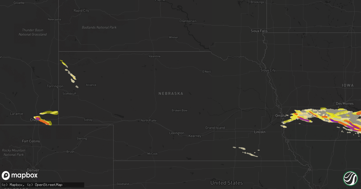
Hail Map in Nebraska on June 18, 2021
Get this storm
June 18 map
$229
one time, instant access
Download today. No call, no setup
Keep the $229
Bought the map and want the full workflow? Apply the entire $229 to a subscription within 7 days. None of it is wasted.
Every map, not just this one
This buys you this map. Subscription and you get every map we run, in the markets you choose from a few cities to whole states to nationwide. Plus real-time alerts the moment a storm fires.
Contact data
Name, contact info, occupancy, even credit band for addresses in the footprint. You go from where it hit to who to call.
Become the source they trust
Unlimited branding weather history reports on demand. You already have the documented answer ready for the property owner, and you are the one who showed up with it.
Property data and RoofTrace estimates
Pull up any address you have got, its value and the exact code rules for that jurisdiction, straight from One Click Code. Then RoofTrace estimates the squares, pitch, and roof value, priced the way you price.
Storm reports in Nebraska
Nebraska
| Date | Description |
|---|---|
| 06/18/20213:02 PM CDT | Brief gustnado captured by trained storm spotters. No damage reported. |
| 06/18/20211:50 PM CDT | A local report indicates 1.25 inch wind near HARRISON |
| 06/18/20216:27 AM CDT | At 1127 PM CDT, a severe thunderstorm was located over Glenwood, or 18 miles southeast of Omaha, moving east at 35 mph. HAZARD...60 mph wind gusts and quarter size hail. SOURCE...Radar indicated. IMPACT...Hail damage to vehicles is expected. Expect wind damage to roofs, siding, and trees. This severe thunderstorm will be near... Malvern around 1145 PM CDT.Other locations in the path of this severe thunderstorm includeEmerson.This includes Interstate 29 between mile markers 27 and 42. |
| 06/18/20214:07 AM CDT | At 907 PM CDT, a severe thunderstorm was located 6 miles west of Western, or 30 miles west of Beatrice, moving east at 45 mph. HAZARD...60 mph wind gusts and quarter size hail. SOURCE...Radar indicated. IMPACT...Hail damage to vehicles is expected. Expect wind damage to roofs, siding, and trees. This severe thunderstorm will be near... Western around 915 PM CDT. |
| 06/18/20213:59 AM CDT | At 859 PM CDT, a severe thunderstorm was located over Bruning, or 34 miles south of York, moving east at 25 mph. HAZARD...Quarter size hail. SOURCE...Radar indicated. IMPACT...Damage to vehicles is expected. This severe thunderstorm will be near... Ohiowa around 915 PM CDT. |
| 06/18/20213:13 AM CDT | At 813 PM MDT, a severe thunderstorm was located 8 miles southwest of Albin, or 30 miles west of Kimball, moving east at 20 mph. HAZARD...60 mph wind gusts and quarter size hail. SOURCE...Radar indicated. IMPACT...Hail damage to vehicles is expected. Expect wind damage to roofs, siding, and trees. Locations impacted include... Albin. |
| 06/17/202110:21 PM CDT | At 320 AM CDT, a severe thunderstorm was located near Ord, moving east at 45 mph. HAZARD...Quarter size hail. SOURCE...Radar indicated. IMPACT...Damage to vehicles is expected. Locations impacted include... Ord, Scotia, North Loup and Elyria. |
| 06/17/20219:15 PM CDT | 3 central pivots flipped. Several large trees down. |
All States Impacted by Hail Map on June 18, 2021
Cities Impacted by Hail Map on June 18, 2021
- Vandalia, OH
- West Milton, OH
- Troy, OH
- Tipp City, OH
- Malvern, IA
- Silver City, IA
- Seymour, IN
- Albin, WY
- Pine Bluffs, WY
- Burns, WY
- Bowling Green, IN
- Coal City, IN
- Clay City, IN
- Terre Haute, IN
- Poland, IN
- Brazil, IN
- Freedom, IN
- Riley, IN
- Patricksburg, IN
- Spencer, IN
- Cory, IN
- Centerpoint, IN
- Greensburg, IN
- Saint Charles, IA
- Indianola, IA
- Prole, IA
- Saint Marys, IA
- Keota, IA
- West Chester, IA
- Washington, IA
- Wellman, IA
- Bussey, IA
- Cantril, IA
- Red Oak, IA
- Wyaconda, MO
- Macedonia, IA
- Centerville, IA
- Pulaski, IA
- Ackworth, IA
- Murray, IA
- Fontanelle, IA
- Griswold, IA
- Lewis, IA
- Peru, IA
- Corydon, IA
- Kahoka, MO
- Drakesville, IA
- Greenfield, IA
- Lacona, IA
- Woodburn, IA
- Truro, IA
- Ursa, IL
- Walnut, IA
- Avoca, IA
- Mystic, IA
- Cumberland, IA
- Stuart, IA
- Lucas, IA
- Alexandria, MO
- Anita, IA
- Mendon, IL
- Moulton, IA
- Winterset, IA
- Humeston, IA
- Downing, MO
- Wiota, IA
- Luray, MO
- Milton, IA
- Afton, IA
- Dexter, IA
- Albia, IA
- Villisca, IA
- Corning, IA
- Blakesburg, IA
- Moravia, IA
- Lorimor, IA
- Plano, IA
- Warsaw, IL
- Arbela, MO
- Atlantic, IA
- Creston, IA
- Orient, IA
- Melrose, IA
- Oakland, IA
- Memphis, MO
- Udell, IA
- Carson, IA
- Massena, IA
- West Point, IL
- Unionville, IA
- New Virginia, IA
- Elliott, IA
- Milo, IA
- Chariton, IA
- Osceola, IA
- Sutter, IL
- Millerton, IA
- Gorin, MO
- Macksburg, IA
- Adair, IA
- Russell, IA
- Derby, IA
- Bridgewater, IA
- Wayland, MO
- Casey, IA
- Canton, MO
- Treynor, IA
- Saint Patrick, MO
- Menlo, IA
- Bloomfield, IA
- Grant, IA
- Henderson, IA
- Promise City, IA
- Hancock, IA
- Columbus, IN
- Stinesville, IN
- Madison, IN
- Worthington, IN
- Tuscola, IL
- Reelsville, IN
- Nineveh, IN
- Lewis, IN
- Redmon, IL
- Stilesville, IN
- West Terre Haute, IN
- Philo, IL
- Commiskey, IN
- Morgantown, IN
- Nashville, IN
- Martinsville, IN
- Villa Grove, IL
- Deputy, IN
- Lexington, IN
- Campbellsburg, KY
- Bedford, KY
- Paris Crossing, IN
- Martinsville, IL
- West Union, IL
- Longview, IL
- Gosport, IN
- North Vernon, IN
- Arcola, IL
- Monrovia, IN
- Dennison, IL
- Austin, IN
- Trafalgar, IN
- Jasonville, IN
- Tolono, IL
- Hindsboro, IL
- Charleston, IL
- Newman, IL
- Ellettsville, IN
- Paragon, IN
- Camargo, IL
- Freetown, IN
- Kansas, IL
- Shelburn, IN
- Marshall, IL
- Westfield, IL
- Farmersburg, IN
- Edinburgh, IN
- Hymera, IN
- Franklin, IN
- Brocton, IL
- Ashmore, IL
- Greencastle, IN
- Fillmore, IN
- Hanover, IN
- Quincy, IN
- Milton, KY
- Pimento, IN
- Cloverdale, IN
- Oakland, IL
- Mooresville, IN
- Crothersville, IN
- Casey, IL
- Paris, IL
- Bargersville, IN
- Pesotum, IL
- Bloomington, IN
- Unionville, IN
- Coatesville, IN
- Clayton, IN
- Sadorus, IL
- Hume, IL
- Murdock, IL
- Valders, WI
- Neenah, WI
- Reedsville, WI
- Menasha, WI
- Brillion, WI
- Stockbridge, WI
- Chilton, WI
- Oshkosh, WI
- Kiel, WI
- Hilbert, WI
- Eaton, OH
- Dayton, OH
- Miamisburg, OH
- Springboro, OH
- Richmond, IN
- New Paris, OH
- New Madison, OH
- Fountain City, IN
- Hollansburg, OH
- Blackduck, MN
- Pennington, MN
- Bemidji, MN
- Knoxville, IA
- Pella, IA
- Alliance, NE
- Fairbury, NE
- Farina, IL
- Pacific Junction, IA
- Van Meter, IA
- Norwalk, IA
- Cumming, IA
- Keosauqua, IA
- Farmington, IA
- Bonaparte, IA
- Donnellson, IA
- Fort Madison, IA
- West Point, IA
- Lawrenceburg, IN
- Petersburg, KY
- Indianapolis, IN
- Marion, WI
- Hemingford, NE
- Harrison, NE
- Fairland, IN
- Fountaintown, IN
- Lovilia, IA
- Dunkirk, IN
- Redkey, IN
- Eaton, IN
- Albany, IN
- Portland, IN
- Ridgeville, IN
- Mccordsville, IN
- Greenfield, IN
- New Palestine, IN
- London Mills, IL
- Maquon, IL
- Saint Augustine, IL
- Abingdon, IL
- Gilson, IL
- Quincy, IL
- Payson, IL
- Liberty, IL
- Plainville, IL
- Pleasantville, IA
- Anderson, IN
- Oskaloosa, IA
- Monmouth, IL
- Morning Sun, IA
- Berwick, IL
- Canton, IL
- Burlington, IA
- Cuba, IL
- Oakville, IA
- Pekin, IL
- Hanna City, IL
- Green Valley, IL
- Oquawka, IL
- Little York, IL
- Danvers, IL
- Tremont, IL
- Minier, IL
- Delavan, IL
- Farmington, IL
- Shirley, IL
- Bloomington, IL
- Glasford, IL
- Yates City, IL
- Trivoli, IL
- Aledo, IL
- Hopedale, IL
- McLean, IL
- Stanford, IL
- Mediapolis, IA
- Knoxville, IL
- South Pekin, IL
- Seaton, IL
- Groveland, IL
- Cameron, IL
- Keithsburg, IL
- Avon, IL
- Kingston Mines, IL
- Norris, IL
- Ellisville, IL
- Galesburg, IL
- Elmwood, IL
- Gerlaw, IL
- Peoria, IL
- Biggsville, IL
- Kirkwood, IL
- Gladstone, IL
- Sperry, IA
- Morton, IL
- Alexis, IL
- Fairview, IL
- Mapleton, IL
- Saint David, IL
- Joy, IL
- Manito, IL
- Mackinaw, IL
- Muncie, IN
- Markleville, IN
- New Castle, IN
- Shirley, IN
- Wilkinson, IN
- Arthur, IL
- Lovington, IL
- Atwood, IL
- Pine River, WI
- Fremont, WI
- Oldenburg, IN
- Waynesville, OH
- Catlin, IL
- Oakwood, IL
- Lerna, IL
- Fairfield, IA
- Brighton, IA
- Middletown, IN
- Kennard, IN
- Pendleton, IN
- Connersville, IN
- Germantown, OH
- Ohiowa, NE
- Alexandria, NE
- Daykin, NE
- Tobias, NE
- Liberty, IN
- Shelbyville, IN
- Rushville, IN
- Manilla, IN
- Milroy, IN
- Waldron, IN
- Sumner, IL
- Cheyenne, WY
- Carpenter, WY
- Oblong, IL
- Ottumwa, IA
- Eddyville, IA
- Winchester, IN
- Farmland, IN
- New London, IA
- Danville, IA
- West Burlington, IA
- Salem, IA
- Middletown, IA
- Wever, IA
- Trenton, OH
- Hamilton, OH
- Cleves, OH
- Miamitown, OH
- Cincinnati, OH
- Wilmington, OH
- Williamsburg, IN
- Iuka, IL
- Winfield, IA
- Columbus City, IA
- Columbus Junction, IA
- Ainsworth, IA
- Crawfordsville, IA
- Wapello, IA
- Springport, IN
- Mooreland, IN
- Daleville, IN
- Springfield, IL
- Pleasant Plains, IL
- Kalona, IA
- Bridgeport, IL
- Minonk, IL
- Fairbury, IL
- Chenoa, IL
- Pontiac, IL
- Weldon, IA
- Leon, IA
- Hillsboro, OH
- Peebles, OH
- Latham, OH
- Milwaukee, WI
- Lockridge, IA
- Council Bluffs, IA
- Clintonville, WI
- Shiocton, WI
- Jansen, NE
- Diller, NE
- Fe Warren Afb, WY
- Union City, OH
- Union City, IN
- Eldon, IA
- Selma, IA
- Floris, IA
- Warren, IN
- Poneto, IN
- Liverpool, IL
- Lewistown, IL
- Arenzville, IL
- Rushville, IL
- Frederick, IL
- Mount Sterling, IL
- Beardstown, IL
- Virginia, IL
- Loami, IL
- New Berlin, IL
- Claremont, IL
- Arcanum, OH
- Fairborn, OH
- Clayton, OH
- Englewood, OH
- Brookville, OH
- Bellbrook, OH
- Spring Valley, OH
- Xenia, OH
- Branson, CO
- Mount Union, IA
- Marion, IN
- Saint Paul, IN
- Wabash, IN
- Bradford, OH
- Yorkshire, OH
- Centerville, IN
- Logansport, IN
- Brooklyn, IN
- Hartford City, IN
- Maria Stein, OH
- Jamestown, OH
- Carrollton, KY
- Boggstown, IN
- Beech Grove, IN
- Brookville, IN
- Ingalls, IN
- Greens Fork, IN
- Modoc, IN
- Ivesdale, IL
- Lynn, IN
- Alpha, OH
- Phillipsburg, OH
- Verona, OH
- Greenup, IL
- Rockford, OH
- Farmersville, OH
- Fishers, IN
- Peru, IN
- New Waverly, IN
- Zionsville, IN
- Sunman, IN
- Scottsburg, IN
- Laurel, IN
- Celina, OH
- West Newton, IN
- Eldorado, OH
- Bluffton, IN
- Greenwood, IN
- Hope, IN
- Fortville, IN
- Berne, IN
- Saint Henry, OH
- Sabina, OH
- Geneva, IN
- West York, IL
- Pittsboro, IN
- Morristown, IN
- Dupont, IN
- Walton, IN
- Palestine, OH
- New Weston, OH
- Bloomfield, IN
- Indianola, IL
- West Manchester, OH
- Brownsburg, IN
- Parker City, IN
- Whiteland, IN
- Broadlands, IL
- Wilberforce, OH
- Bryant, IN
- Upland, IN
- Knightstown, IN
- Economy, IN
- Hammond, IL
- Pitsburg, OH
- Plainfield, IN
- Ansonia, OH
- West Alexandria, OH
- Decatur, IL
- Staunton, IN
- Keystone, IN
- Chrisman, IL
- Ridge Farm, IL
- Batesville, IN
- Argenta, IL
- Bement, IL
- Norman, IN
- Annapolis, IL
- Oreana, IL
- Sidell, IL
- Pleasureville, KY
- New Vienna, OH
- Hutsonville, IL
- Allerton, IL
- Selma, IN
- Harmony, IN
- Straughn, IN
- Greenville, OH
- Cerro Gordo, IL
- Leesburg, OH
- La Fontaine, IN
- Coalmont, IN
- Camden, OH
- Cambridge City, IN
- Flat Rock, IN
- Losantville, IN
- Lewisburg, OH
- Carmel, IN
- Solsberry, IN
- Camby, IN
- Metcalf, IL
- Rossburg, OH
- La Place, IL
- Webster, IN
- Versailles, OH
- New Lebanon, OH
- Turners Station, KY
- Saratoga, IN
- Franklin, OH
- Hagerstown, IN
- Fairbanks, IN
- Laura, OH
- Covington, OH
- Port William, OH
- Needham, IN
- Brownstown, IN
- Coldwater, OH
- Knightsville, IN
- Fort Recovery, OH
- Golden, IL
- Loraine, IL
- Camp Point, IL
- Westfield, IN
- Delta, IA
- Rose Hill, IA
- Fremont, IA
- Hedrick, IA
- Lamar, CO
- Noblesville, IN
- Plattsmouth, NE
- Novelty, MO
- Chatham, IL
- Alexander, IL
- Guilford, IN
- Aurora, IN
- Milan, IN
- Jacksonville, IL
- Ashland, IL
- La Harpe, IL
- Blandinsville, IL
- Brownstown, IL
- Kinmundy, IL
- Harvey, IA
- Burlington, KY
- Lizton, IN
- Edgewood, IL
- Columbia, IA
- Cedar, IA
- Ollie, IA
- Verona, KY
- Warsaw, KY
- Glencoe, KY
- Dry Ridge, KY
- Auburn, IN
- Garrett, IN
- Laotto, IN
- Sullivan, IN
- Saint Elmo, IL
- Beecher City, IL
- Plainville, IN
- Washington, IN
- Mt Zion, IL
- What Cheer, IA
- Sigourney, IA
- Newton, IL
- Trilla, IL
- Mattoon, IL
- Vandalia, IL
- Ramsey, IL
- Texico, IL
- Kell, IL
- Xenia, IL
- Salem, IL
- Johnsonville, IL
- Wayland, IA
- Mount Pleasant, IA
- Strasburg, IL
- Shelbyville, IL
- La Grange, MO
- Fowler, IL
- Flat Rock, IL
- Melcher Dallas, IA
- Mason, OH
- South Lebanon, OH
- Morrow, OH
- Maineville, OH
- Blanchester, OH
- Kings Mills, OH
- Lebanon, OH
- Pleasant Plain, OH
- Glenwood, IA
- Livonia, MO
- Smithfield, IL
- Roseville, IL
- Yarmouth, IA
- Watseka, IL
- Sheldon, IL
- Tipton, IN
- Lawrenceville, IL
- Sheridan, IN
- Cicero, IN
- Arcadia, IN
- Greenfield, OH
- Larsen, WI
- Waupaca, WI
- Winneconne, WI
- Wild Rose, WI
- Walton, KY
- Crittenden, KY
- Morning View, KY
- Chapin, IL
- Concord, IL
- Coatsburg, IL
- Brownsville, IN
- Columbia City, IN
- Churubusco, IN
- Hebron, KY
- Florence, KY
- North Bend, OH
- Union, KY
- Willow Hill, IL
- Lapel, IN
- Hortonville, WI
- New London, WI
- Butler, IN
- Cantrall, IL
- Harper, IA
- Riverside, IA
- Camden, IL
- Timewell, IL
- Clayton, IL
- Huntsville, IL
- Chandlerville, IL
- Shobonier, IL
- West Chester, OH
- Hines, MN
- Olney, IL
- West Salem, IL
- Calhoun, IL
- Mount Carmel, IL
- Parkersburg, IL
- Leo, IN
- Huntertown, IN
- Fort Wayne, IN
- Lomax, IL
- Dallas City, IL
- Carthage, IL
- Dugger, IN
- Linton, IN
- Mechanicsburg, IL
- Rochester, IL
- Riverton, IL
- Tallula, IL
- Dawson, IL
- Forrest, IL
- Elizabethtown, IN
- Waterloo, WI
- Converse, IN
- Carlisle, IN
- North Prairie, WI
- Mukwonago, WI
- Waterloo, IN
- Garden Grove, IA
- East Peoria, IL
- Saint Joseph, IL
- Ogden, IL
- Kimberly, WI
- Appleton, WI
- Montgomery, IN
- Decatur, IN
- Ohio City, OH
- Roachdale, IN
- North Salem, IN
- West Liberty, IL
- Oxford, OH
- Fairmount, IL
- Mount Vernon, IL
- Woodlawn, IL
- Dix, IL
- Bluford, IL
- Clarksville, OH
- Milton, IN
- Bainbridge, OH
- Whitestown, IN
- Ladoga, IN
- New Ross, IN
- Crawfordsville, IN
- Chalmers, IN
- Reynolds, IN
- Roanoke, IN
- Brooksville, KY
- Foster, KY
- Odell, NE
- Monroe, IN
- Sandborn, IN
- Westphalia, IN
- Elnora, IN
- Tracy, IA
- Rosedale, IN
- Seymour, IA
- Willshire, OH
- Saint Peter, IL
- Independence, KY
- Patriot, IN
- Florence, IN
- Bennington, IN
- Osgood, IN
- Hooven, OH
- West Harrison, IN
- Moores Hill, IN
- Dillsboro, IN
- Rising Sun, IN
- Collins, WI
- Erlanger, KY
- Robinson, IL
- Heyworth, IL
- Fithian, IL
- Danville, IN
- Amo, IN
- Yale, IL
- Hamilton, IA
- Yoder, IN
- Fairfield, OH
- Bingham, IL
- Beatrice, NE
- Shickley, NE
- Bruning, NE
- Strang, NE
- Blue Springs, NE
- College Corner, OH
- Fisher, IL
- Mahomet, IL
- Dewey, IL
- Somerville, OH
- Middletown, OH
- Bainbridge, IN
- Charlottesville, IN
- Carthage, IN
- Oregonia, OH
- Lynchburg, OH
- Martinsville, OH
- New Trenton, IN
- Oaktown, IN
- Edwardsport, IN
- Bicknell, IN
- Argyle, IA
- Exline, IA
- Hayesville, IA
- Williamstown, MO
- East Galesburg, IL
- Monticello, MO
- Rutledge, MO
- Paloma, IL
- Montrose, IA
- Ewing, MO
- Leighton, IA
- Patterson, IA
- Bevington, IA
- New Boston, IL
- Armington, IL
- Douds, IA
- Emerson, IA
- Earlham, IA
- Olds, IA
- Minden, IA
- Maywood, MO
- North Henderson, IL
- Mount Sterling, IA
- Bellevue, NE
- Revere, MO
- South English, IA
- Cincinnati, IA
- Saint Francisville, IL
- Allerton, IA
- New Bremen, OH
- Minster, OH
- Sidney, IL
- Cedar Grove, IN
- Okeana, OH
- Sparta, KY
- Normal, IL
- Carlock, IL
- Grover, CO
- Fayetteville, OH
- Aberdeen, OH
- Bethel, OH
- Winchester, OH
- Wallingford, KY
- Hamersville, OH
- Sardinia, OH
- Owensville, OH
- Ripley, OH
- Mayslick, KY
- Augusta, KY
- Dover, KY
- Manchester, OH
- Vanceburg, KY
- Russellville, OH
- Flemingsburg, KY
- Goshen, OH
- Batavia, OH
- Georgetown, OH
- West Union, OH
- Mount Orab, OH
- Williamsburg, OH
- Midland, OH
- Maysville, KY
- Tollesboro, KY
- Emerson, KY
- Blue Creek, OH
- Stout, OH
- Greenup, KY
- Olive Hill, KY
- South Shore, KY
- Garrison, KY
- Argillite, KY
- West Portsmouth, OH
- South Portsmouth, KY
- Friendship, OH
- Quincy, KY
- Otway, OH
- Grayson, KY
- Owingsville, KY
- Moorefield, KY
- Morehead, KY
- Olympia, KY
- West Liberty, KY
- Ezel, KY
- Ewing, KY
- Germantown, KY
- Frenchburg, KY
- Hillsboro, KY
- Mount Olivet, KY
- Salt Lick, KY
- Clearfield, KY
- Wellington, KY
- Carlisle, KY
- Sharpsburg, KY
- Mineola, IA
- Yellow Springs, OH
- Cedarville, OH
- Spiceland, IN
- Lewisville, IN
- Versailles, IN
- Napoleon, IN
- Springville, IN
- Avoca, IN
- Medora, IN
- Oolitic, IN
- Bedford, IN
- Heltonville, IN
- Squaw Lake, MN
- Putnamville, IN
- Homer, IN


