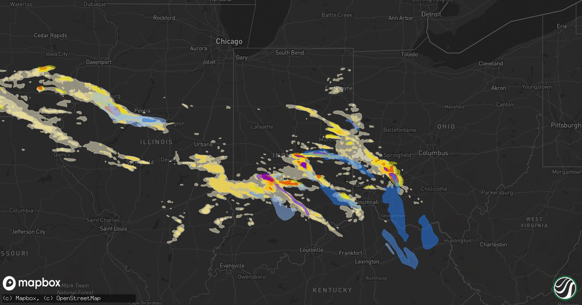
Hail Map in Indiana on June 18, 2021
Get this storm
June 18 map
$229
one time, instant access
Download today. No call, no setup
Keep the $229
Bought the map and want the full workflow? Apply the entire $229 to a subscription within 7 days. None of it is wasted.
Every map, not just this one
This buys you this map. Subscription and you get every map we run, in the markets you choose from a few cities to whole states to nationwide. Plus real-time alerts the moment a storm fires.
Contact data
Name, contact info, occupancy, even credit band for addresses in the footprint. You go from where it hit to who to call.
Become the source they trust
Unlimited branding weather history reports on demand. You already have the documented answer ready for the property owner, and you are the one who showed up with it.
Property data and RoofTrace estimates
Pull up any address you have got, its value and the exact code rules for that jurisdiction, straight from One Click Code. Then RoofTrace estimates the squares, pitch, and roof value, priced the way you price.
Storm reports in Indiana
Indiana
| Date | Description |
|---|---|
| 06/18/20216:59 PM CDT | A local report indicates 68 MPH wind near 3 ESE FAIRLAND |
| 06/18/20216:55 PM CDT | Time estimated from radar. |
| 06/18/20216:54 PM CDT | A local report indicates 1.75 inch wind near 1 NNE NEW PALESTINE |
| 06/18/20216:54 PM CDT | Trees and power lines blown down across the county. |
| 06/18/20216:50 PM CDT | Trees down. |
| 06/18/20216:50 PM CDT | A local report indicates 2.50 inch wind near NEW PALESTINE |
| 06/18/20216:47 PM CDT | Trees down. |
| 06/18/20216:47 PM CDT | A local report indicates 1.00 inch wind near 5 WSW NEW PALESTINE |
| 06/18/20216:45 PM CDT | Time estimated from radar. |
| 06/18/20216:44 PM CDT | A local report indicates 1.00 inch wind near 3 SSW NEW CASTLE |
| 06/18/20216:43 PM CDT | Tree down across road. Time estimated from radar. |
| 06/18/20216:40 PM CDT | A local report indicates 2.00 inch wind near 2 NNE NEW PALESTINE |
| 06/18/20216:40 PM CDT | A local report indicates 1.00 inch wind near 1 WNW NEW PALESTINE |
| 06/18/20216:40 PM CDT | Large tree down as well. |
| 06/18/20216:40 PM CDT | Time estimated from radar. |
| 06/18/20216:35 PM CDT | A local report indicates 1.75 inch wind near 2 WNW NEW CASTLE |
| 06/18/20216:35 PM CDT | A local report indicates 60 MPH wind near 2 WNW NEW CASTLE |
| 06/18/20216:30 PM CDT | Time estimated from radar. Size estimated from photo. |
| 06/18/20216:30 PM CDT | A local report indicates 1.75 inch wind near 3 SSE WARREN PARK |
| 06/18/20216:30 PM CDT | Time estimated from radar. Size estimated from photo. |
| 06/18/20216:30 PM CDT | Time estimated from radar. Report from 775 east. |
| 06/18/20216:26 PM CDT | A local report indicates 2.50 inch wind near 1 ESE CLOVERDALE |
| 06/18/20216:22 PM CDT | A local report indicates 2.00 inch wind near 3 ENE PUTNAMVILLE |
| 06/18/20216:21 PM CDT | A local report indicates 1.00 inch wind near 3 NE MONROVIA |
| 06/18/20216:20 PM CDT | A local report indicates 1.75 inch wind near 3 ENE WARREN PARK |
| 06/18/20216:20 PM CDT | Trees down and some house damage near intersection of home and maple streets. |
| 06/18/20216:20 PM CDT | Several trees down as well. |
| 06/18/20216:12 PM CDT | A local report indicates 1.75 inch wind near 2 ENE PUTNAMVILLE |
| 06/18/20216:10 PM CDT | Time estimated from radar. Social media post from lawrence. Photo with two 1.75 inch stones next to a quarter. Several other stones 1.00 to 1.50 inches. |
| 06/18/20216:07 PM CDT | A local report indicates 2.00 inch wind near 1 SSE GEIST RESERVOIR |
| 06/18/20216:02 PM CDT | A local report indicates 1.00 inch wind near MCCORDSVILLE |
| 06/18/20216:00 PM CDT | A local report indicates 1.00 inch wind near 2 N MCCORDSVILLE |
| 06/18/20216:00 PM CDT | Time estimated from radar. |
| 06/18/20215:59 PM CDT | Tree down across road. Reports of storm related power outages across town as well. Time estimated from radar. |
| 06/18/20215:58 PM CDT | A local report indicates 1.00 inch wind near 2 SW CASTLETON |
| 06/18/20215:58 PM CDT | Another correction to previous hail report from 1 w castleton. Now adding that cars damaged in castleton square mall. |
| 06/18/20215:58 PM CDT | A local report indicates 1.00 inch wind near 6 NE SARATOGA |
| 06/18/20215:56 PM CDT | A local report indicates 1.25 inch wind near 2 S CASTLETON |
| 06/18/20215:55 PM CDT | A local report indicates 1.75 inch wind near 2 NE NORA |
| 06/18/20215:55 PM CDT | A local report indicates 2.00 inch wind near CASTLETON |
| 06/18/20215:51 PM CDT | A local report indicates 1.25 inch wind near 1 N NORA |
| 06/18/20215:50 PM CDT | A local report indicates 1.50 inch wind near 1 SSW CASTLETON |
| 06/18/20215:50 PM CDT | A local report indicates 1.00 inch wind near 1 S CASTLETON |
| 06/18/20215:48 PM CDT | A local report indicates 1.00 inch wind near 1 W CASTLETON |
| 06/18/20215:47 PM CDT | A local report indicates 1.00 inch wind near 1 SE CARMEL |
| 06/18/20215:45 PM CDT | 1.00 inch hail in fishers. Size estimated from photo. |
| 06/18/20215:44 PM CDT | A local report indicates 1.25 inch wind near 2 S CARMEL |
| 06/18/20215:42 PM CDT | A local report indicates 1.00 inch wind near 2 NNW NORA |
| 06/18/20214:12 PM CDT | A local report indicates 1.00 inch wind near 3 ESE RIDGEVILLE |
| 06/18/20213:35 PM CDT | Delayed report. |
| 06/18/20213:34 PM CDT | Dime to quarter size hail. |
| 06/18/20212:57 PM CDT | Large wedge tornado reported on the ground moving ese. Approximately 200 yards wide. |
| 06/18/20212:27 PM CDT | Estimated quarter size hail near hwy 35 and 67. |
| 06/18/20217:42 AM CDT | Powerlines down. |
| 06/18/20217:27 AM CDT | Large limb fell onto a house... Motorhome and power lines. Time estimated from radar. |
| 06/18/20217:20 AM CDT | Tree that fell into wires. Both are in the roadway. Time estimated from radar. |
| 06/18/20217:10 AM CDT | Tree blocking the west lane of the roadway. Time estimated from radar. |
| 06/18/20217:08 AM CDT | Tree blocking roadway. |
| 06/18/20217:05 AM CDT | Tree fell onto a house and took down phone lines. Time estimated from radar. |
| 06/18/20217:05 AM CDT | Tree in roadway. |
| 06/18/20216:03 AM CDT | At 1103 PM EDT, a severe thunderstorm was located near Bloomington, moving southeast at 25 mph. HAZARD...60 mph wind gusts and quarter size hail. SOURCE...Radar indicated. IMPACT...Hail damage to vehicles is expected. Expect wind damage to roofs, siding, and trees. This severe thunderstorm will be near... Charles Deam Wilderness around 1115 PM EDT.Other locations in the path of this severe thunderstorm includeElkinsville, Story, Stone Head, Norman, Spurgeons Corner and Kurtz. |
| 06/18/20215:32 AM CDT | At 1031 PM CDT, a severe thunderstorm was located near Annapolis, or 13 miles north of Robinson, moving east at 30 mph. HAZARD...60 mph wind gusts and quarter size hail. SOURCE...Radar indicated. IMPACT...Hail damage to vehicles is expected. Expect wind damage to roofs, siding, and trees. This severe thunderstorm will be near... West Union around 1040 PM CDT. Hutsonville around 1045 PM CDT. |
| 06/18/20215:29 AM CDT | At 1029 PM EDT, a severe thunderstorm was located 8 miles southeast of Seymour, moving east at 30 mph. HAZARD...60 mph wind gusts and quarter size hail. SOURCE...Radar indicated. IMPACT...Hail damage to vehicles is expected. Expect wind damage to roofs, siding, and trees. This severe thunderstorm will remain over mainly rural areas of northwestern Jefferson and north central Scott Counties, including the following locations... Wakefield, Middlefork, Dupont, Volga, Five Points and Deputy. |
| 06/18/20215:11 AM CDT | At 1011 PM EDT, a severe thunderstorm was located over Seymour, moving southeast at 20 mph. HAZARD...60 mph wind gusts and quarter size hail. SOURCE...Radar indicated. IMPACT...Hail damage to vehicles is expected. Expect wind damage to roofs, siding, and trees. This severe thunderstorm will be near... Hayden around 1030 PM EDT.Other locations in the path of this severe thunderstorm includeVernon and Paris Crossing.This includes Interstate 65 between mile markers 37 and 54. |
| 06/18/20214:45 AM CDT | At 944 PM EDT, a severe thunderstorm was located 7 miles southeast of Franklin, or 13 miles north of Columbus, moving east at 20 mph. HAZARD...Half dollar size hail. SOURCE...Radar indicated. IMPACT...Damage to vehicles is expected. This severe thunderstorm will be near... Edinburgh around 950 PM EDT. Taylorsville around 955 PM EDT. Marietta around 1000 PM EDT.Other locations in the path of this severe thunderstorm include FlatRock and Clifford.This includes Interstate 65 between mile markers 76 and 86. |
| 06/18/20214:44 AM CDT | At 944 PM CDT, severe thunderstorms were located along a line extending from near Marshall to near Toledo, moving east at 30 mph. HAZARD...60 mph wind gusts and quarter size hail. SOURCE...Radar indicated. IMPACT...Hail damage to vehicles is expected. Expect wind damage to roofs, siding, and trees. Locations impacted include... Hazel Dell, Casey, Martinsville and West Union.This includes Interstate 70 between mile markers 109 and 154. |
| 06/18/20214:32 AM CDT | At 932 PM EDT, a severe thunderstorm was located 12 miles northwest of Seymour, moving southeast at 20 mph. HAZARD...Golf ball size hail and 60 mph wind gusts. SOURCE...Radar indicated. IMPACT...People and animals outdoors will be injured. Expect hail damage to roofs, siding, windows, and vehicles. Expect wind damage to roofs, siding, and trees. Locations impacted include... Jonesville, Cortland and Seymour.This includes Interstate 65 between mile markers 50 and 63. |
| 06/18/20214:30 AM CDT | At 929 PM EDT, severe thunderstorms were located along a line extending from Florence to near Union to near Rising Sun, moving southeast at 40 mph. HAZARD...70 mph wind gusts. SOURCE...Radar indicated. IMPACT...Expect considerable tree damage. Damage is likely to mobile homes, roofs, and outbuildings. Locations impacted include... Florence, Erlanger, Villa Hills, Walton, Rising Sun, Oakbrook, Burlington, Union, Crittenden, Patriot, Richwood, Pate, Ryle, Big Bone Lick, Steele Bottom, US Routes 42 and 127 at State Route 562, Rabbit Hash, Hueys Corners, Constance and Beaverlick.This includes the following Interstates... I-71 in Kentucky between mile markers 66 and 77. I-75 in Kentucky between mile markers 170 and 183. |
| 06/18/20214:29 AM CDT | At 929 PM EDT, a severe thunderstorm was located near Spencer, or 14 miles northwest of Bloomington, moving southeast at 25 mph. HAZARD...Quarter size hail. SOURCE...Radar indicated. IMPACT...Damage to vehicles is expected. This severe thunderstorm will be near... Stinesville around 940 PM EDT. Ellettsville around 945 PM EDT.Other locations in the path of this severe thunderstorm includeBloomington, Unionville, Lake Lemon and Woodville Hills. |
| 06/18/20214:23 AM CDT | At 923 PM EDT, a severe thunderstorm was located near Martinsville, or 22 miles northeast of Bloomington, moving east at 20 mph. HAZARD...60 mph wind gusts and half dollar size hail. SOURCE...Radar indicated. IMPACT...Hail damage to vehicles is expected. Expect wind damage to roofs, siding, and trees. This severe thunderstorm will be near... Morgantown around 940 PM EDT.Other locations in the path of this severe thunderstorm includeBargersville, Trafalgar, New Whiteland, Princes Lakes, Franklin andWhiteland. |
| 06/18/20214:07 AM CDT | At 906 PM EDT, a severe thunderstorm was located 12 miles north of Spencer, or 21 miles northwest of Bloomington, moving east at 15 mph. HAZARD...60 mph wind gusts and quarter size hail. SOURCE...Radar indicated. IMPACT...Hail damage to vehicles is expected. Expect wind damage to roofs, siding, and trees. Locations impacted include... Paragon and Martinsville. |
| 06/18/20213:59 AM CDT | At 859 PM EDT, a severe thunderstorm was located near Lake Santee, or near Batesville, moving east at 15 mph. HAZARD...60 mph wind gusts and quarter size hail. SOURCE...Radar indicated. IMPACT...Hail damage to vehicles is expected. Expect wind damage to roofs, siding, and trees. This severe thunderstorm will remain over mainly rural areas of southeastern Rush and eastern Decatur Counties.This includes Interstate 74 between mile markers 138 and 144. |
| 06/18/20213:45 AM CDT | At 845 PM EDT, a severe thunderstorm was located near Nashville, or 11 miles northeast of Bloomington, moving southeast at 25 mph. HAZARD...60 mph wind gusts and half dollar size hail. SOURCE...Radar indicated. IMPACT...Hail damage to vehicles is expected. Expect wind damage to roofs, siding, and trees. This severe thunderstorm will be near... Helmsburg and Beanblossom around 850 PM EDT. Yellowwood Lake around 855 PM EDT. Nashville around 905 PM EDT.Other locations in the path of this severe thunderstorm include GnawBone, Story, Stone Head and Spurgeons Corner.This includes Interstate 65 near mile marker 70. |
| 06/18/20213:44 AM CDT | At 844 PM EDT, severe thunderstorms were located along a line extending from near Lake Santee to 7 miles northwest of Osgood, moving east at 40 mph. HAZARD...60 mph wind gusts. SOURCE...Radar indicated. IMPACT...Expect damage to trees and power lines. Locations impacted include... Batesville, Brookville, Versailles, Milan, Osgood, Oldenburg, Moores Hill, Lake Santee, Manchester, Blooming Grove, Sunman, Metamora, St. Leon, Laurel, Holton, Napoleon, Cedar Grove, Millhousen, Mounds State Recreation Area and Huntersville.This includes I-74 in Indiana between mile markers 145 and 164. |
| 06/18/20213:14 AM CDT | At 814 PM EDT, a severe thunderstorm was located near New Paris, moving east at 45 mph. HAZARD...60 mph wind gusts and quarter size hail. SOURCE...Radar indicated. IMPACT...Minor hail damage to vehicles is possible. Expect wind damage to trees and power lines. Locations impacted include... Richmond, Trotwood, Eaton, Camden, Lewisburg, New Paris, West Alexandria, Gratis, Brookville, New Lebanon, Farmersville, Spring Grove, West Elkton, Boston, Richmond Municipal Airport, Oklahoma, West Florence, Wheatville, Interstate 70 at US Route 127 and Muttonville.This includes the following Interstates... I-70 in Indiana between mile markers 152 and 156. I-70 in Ohio between mile markers 0 and 19. |
| 06/18/20213:08 AM CDT | At 808 PM EDT, a severe thunderstorm was located over Shelbyville, moving southeast at 30 mph. HAZARD...60 mph wind gusts and quarter size hail. SOURCE...Radar indicated. IMPACT...Hail damage to vehicles is expected. Expect wind damage to roofs, siding, and trees. This severe thunderstorm will be near... Waldron around 820 PM EDT. Geneva around 825 PM EDT.Other locations in the path of this severe thunderstorm include St.Paul, Moscow, Milford, Burney, Adams, Greensburg, Sandusky,Millhousen and Newpoint.This includes the following highways... Interstate 65 between mile markers 77 and 83. Interstate 74 between mile markers 108 and 144. |
| 06/18/20212:45 AM CDT | At 745 PM EDT, a severe thunderstorm was located 11 miles west of Martinsville, or 21 miles north of Bloomington, moving southeast at 30 mph. HAZARD...Golf ball size hail and 60 mph wind gusts. SOURCE...Radar indicated. IMPACT...People and animals outdoors will be injured. Expect hail damage to roofs, siding, windows, and vehicles. Expect wind damage to roofs, siding, and trees. This severe thunderstorm will be near... Paragon around 755 PM EDT. Martinsville around 805 PM EDT.Other locations in the path of this severe thunderstorm includeMahalasville, Lake Lemon and Morgantown.This includes Interstate 70 near mile marker 50. |
| 06/18/20212:31 AM CDT | At 731 PM EDT, a severe thunderstorm was located near Beech Grove, or 9 miles southeast of Indianapolis, moving southeast at 25 mph. HAZARD...Two inch hail and 60 mph wind gusts. SOURCE...Radar indicated. IMPACT...People and animals outdoors will be injured. Expect hail damage to roofs, siding, windows, and vehicles. Expect wind damage to roofs, siding, and trees. This severe thunderstorm will be near... New Palestine around 740 PM EDT.Other locations in the path of this severe thunderstorm includeFairland, Morristown, Shelbyville and Manilla.This includes the following highways... Interstate 70 near mile marker 89. Interstate 74 between mile markers 93 and 123. |
| 06/18/20212:15 AM CDT | At 714 PM EDT, a severe thunderstorm was located near Greenfield, or 15 miles south of Anderson, moving southeast at 35 mph. HAZARD...Two inch hail and 60 mph wind gusts. SOURCE...Radar indicated. IMPACT...People and animals outdoors will be injured. Expect hail damage to roofs, siding, windows, and vehicles. Expect wind damage to roofs, siding, and trees. This severe thunderstorm will be near... Shirley and Wilkinson around 720 PM EDT. Kennard around 725 PM EDT. Knightstown, Carthage and Greensboro around 730 PM EDT.Other locations in the path of this severe thunderstorm includeSpiceland, Dunreith, Mays, Lewisville, Straughn and Glenwood.This includes Interstate 70 between mile markers 90 and 133. |
| 06/18/20211:55 AM CDT | At 655 PM EDT, a severe thunderstorm was located 8 miles east of Brazil, or 22 miles east of Terre Haute, moving southeast at 30 mph. HAZARD...Golf ball size hail and 60 mph wind gusts. SOURCE...Radar indicated. IMPACT...People and animals outdoors will be injured. Expect hail damage to roofs, siding, windows, and vehicles. Expect wind damage to roofs, siding, and trees. This severe thunderstorm will be near... Cloverdale and Cagles Mill Lake around 710 PM EDT.Other locations in the path of this severe thunderstorm includeDevore, Quincy, Spencer, Gosport and Paragon.This includes Interstate 70 between mile markers 28 and 50. |
| 06/18/20211:42 AM CDT | At 642 PM EDT, a severe thunderstorm was located near Carmel, or 7 miles north of Indianapolis, moving southeast at 45 mph. HAZARD...60 mph wind gusts and quarter size hail. SOURCE...Radar indicated. IMPACT...Hail damage to vehicles is expected. Expect wind damage to roofs, siding, and trees. This severe thunderstorm will be near... Warren Park and Geist Reservoir around 650 PM EDT. Lawrence and McCordsville around 655 PM EDT. Cumberland around 700 PM EDT.Other locations in the path of this severe thunderstorm include NewPalestine and Spring Lake.This includes the following highways... Interstate 69 between mile markers 200 and 208. Interstate 70 between mile markers 87 and 101. |
| 06/17/202110:58 PM CDT | At 358 PM EDT, a severe thunderstorm was located near Hartford City, moving southeast at 30 mph. HAZARD...70 mph wind gusts and quarter size hail. SOURCE...Radar indicated. IMPACT...Hail damage to vehicles is expected. Expect considerable tree damage. Wind damage is also likely to mobile homes, roofs, and outbuildings. This severe thunderstorm will be near... Montpelier around 405 PM EDT. Pennville around 420 PM EDT. Dunkirk around 425 PM EDT. Redkey around 430 PM EDT.Other locations impacted by this severe thunderstorm include Center,Blaine, Powers, Trenton, Roll, New Mount Pleasant, Mill Grove andComo. |
| 06/17/202110:28 PM CDT | At 327 PM EDT, a severe thunderstorm was located near La Fontaine, or near Marion, moving east at 25 mph. HAZARD...70 mph wind gusts and half dollar size hail. SOURCE...Radar indicated. IMPACT...Hail damage to vehicles is expected. Expect considerable tree damage. Wind damage is also likely to mobile homes, roofs, and outbuildings. Locations impacted include... Marion, Montpelier, La Fontaine, Van Buren, Warren, Mcnatts, Landess, Mount Zion, Dillman, Jalapa, Hanfield, Keystone, Banquo, Roll, Lake Wood and Arcana.This includes Interstate 69 in Indiana between mile markers 263 and274. |
| 06/17/20219:52 PM CDT | At 252 PM EDT, a severe thunderstorm was located near Wabash, moving east at 30 mph. HAZARD...70 mph wind gusts and half dollar size hail. SOURCE...Radar indicated. IMPACT...Hail damage to vehicles is expected. Expect considerable tree damage. Wind damage is also likely to mobile homes, roofs, and outbuildings. Locations impacted include... Marion, Wabash, La Fontaine, Lancaster, Mount Etna, Landess, Lincolnville, Jalapa, Santa Fe, Hanfield, Treaty, Majenica, Banquo, Peoria, Lake Wood, Somerset and Pleasant Plain.This includes Interstate 69 in Indiana between mile markers 265 and272. |
| 06/17/20219:51 PM CDT | Delayed report...twitter post about lots of debris and trees down on blake road south of deputy. Time estimated from radar. |
| 06/17/20218:55 PM CDT | A local report indicates 1.00 inch wind near 5 ENE STINESVILLE |
| 06/17/20218:47 PM CDT | Tree and limbs down on interstate 65 causing traffic backup. |
| 06/17/20218:47 PM CDT | Half inch hail as well. |
| 06/17/20218:45 PM CDT | A local report indicates 1.75 inch wind near 1 SSW GOSPORT |
| 06/17/20218:28 PM CDT | A local report indicates 1.75 inch wind near 4 NW MORGANTOWN |
| 06/17/20218:17 PM CDT | A local report indicates 1.75 inch wind near 2 NW MARTINSVILLE |
| 06/17/20218:15 PM CDT | Public report of roof damage to a buisness in hidden valley... In. |
| 06/17/20218:12 PM CDT | A local report indicates 59 MPH wind near LAWRENCEBURG |
| 06/17/20218:01 PM CDT | Nws storm survey confirms an ef-1 tornado with a path length of one-half mile. |
| 06/17/20217:58 PM CDT | Extensive and considerable tree damage at multiple properties near the intersection of east county rd. 475 n and north county rd 850 e. Time estimated by radar. |
| 06/17/20217:56 PM CDT | Many downed trees and power lines across roadways county wide. Time estimed from radar for versailles. |
| 06/17/20217:55 PM CDT | Roof reported off a home. A tree knocked down into a house. Barn damage reported. Time estimated from radar. |
| 06/17/20217:51 PM CDT | Nws storm survey confirms an ef-1 tornado with a path length of 6.2 miles. |
| 06/17/20217:47 PM CDT | Tree reported into a house. No injuries. Time estimated from radar. |
| 06/17/20217:47 PM CDT | Trees down across northeastern decatur county. |
| 06/17/20217:47 PM CDT | A local report indicates 58 MPH wind near BATESVILLE |
| 06/17/20217:45 PM CDT | Trees and power lines were blown down across the county. A house was struck by lightning at hidden valley lake. |
| 06/17/20217:44 PM CDT | Roof off a building. |
| 06/17/20217:40 PM CDT | A local report indicates 1.00 inch wind near LAKE LEMON |
| 06/17/20217:13 PM CDT | Large tree down and fell on deck. Reports of other trees down nearby. Time estimated from radar. |
| 06/17/20217:00 PM CDT | Time estimated from radar. Top half of tree snapped off. Another tree uprooted and into barn door. 1377 west 900 north. |
| 06/17/20217:00 PM CDT | Time estimated from radar. Mature tree snapped at base. Few power lines and poles blown over. Large segment of metal barn roof blown off. Several branches blown down. 3 |
| 06/17/20217:00 PM CDT | Time estimated from radar. Top segment of slio blown off. 2582 west 800 north. |
| 06/17/20217:00 PM CDT | Time estimated from radar. 900n impassable from 200w to 400w with trees and powerlines on road. 5 trees in a row downed at 325w. |
| 06/17/20217:00 PM CDT | Time estimated from radar. Larger tree uprooted... Smaller tree snapped. 1949w 900n. |
All States Impacted by Hail Map on June 18, 2021
Cities Impacted by Hail Map on June 18, 2021
- Vandalia, OH
- West Milton, OH
- Troy, OH
- Tipp City, OH
- Malvern, IA
- Silver City, IA
- Seymour, IN
- Albin, WY
- Pine Bluffs, WY
- Burns, WY
- Bowling Green, IN
- Coal City, IN
- Clay City, IN
- Terre Haute, IN
- Poland, IN
- Brazil, IN
- Freedom, IN
- Riley, IN
- Patricksburg, IN
- Spencer, IN
- Cory, IN
- Centerpoint, IN
- Greensburg, IN
- Saint Charles, IA
- Indianola, IA
- Prole, IA
- Saint Marys, IA
- Keota, IA
- West Chester, IA
- Washington, IA
- Wellman, IA
- Bussey, IA
- Cantril, IA
- Red Oak, IA
- Wyaconda, MO
- Macedonia, IA
- Centerville, IA
- Pulaski, IA
- Ackworth, IA
- Murray, IA
- Fontanelle, IA
- Griswold, IA
- Lewis, IA
- Peru, IA
- Corydon, IA
- Kahoka, MO
- Drakesville, IA
- Greenfield, IA
- Lacona, IA
- Woodburn, IA
- Truro, IA
- Ursa, IL
- Walnut, IA
- Avoca, IA
- Mystic, IA
- Cumberland, IA
- Stuart, IA
- Lucas, IA
- Alexandria, MO
- Anita, IA
- Mendon, IL
- Moulton, IA
- Winterset, IA
- Humeston, IA
- Downing, MO
- Wiota, IA
- Luray, MO
- Milton, IA
- Afton, IA
- Dexter, IA
- Albia, IA
- Villisca, IA
- Corning, IA
- Blakesburg, IA
- Moravia, IA
- Lorimor, IA
- Plano, IA
- Warsaw, IL
- Arbela, MO
- Atlantic, IA
- Creston, IA
- Orient, IA
- Melrose, IA
- Oakland, IA
- Memphis, MO
- Udell, IA
- Carson, IA
- Massena, IA
- West Point, IL
- Unionville, IA
- New Virginia, IA
- Elliott, IA
- Milo, IA
- Chariton, IA
- Osceola, IA
- Sutter, IL
- Millerton, IA
- Gorin, MO
- Macksburg, IA
- Adair, IA
- Russell, IA
- Derby, IA
- Bridgewater, IA
- Wayland, MO
- Casey, IA
- Canton, MO
- Treynor, IA
- Saint Patrick, MO
- Menlo, IA
- Bloomfield, IA
- Grant, IA
- Henderson, IA
- Promise City, IA
- Hancock, IA
- Columbus, IN
- Stinesville, IN
- Madison, IN
- Worthington, IN
- Tuscola, IL
- Reelsville, IN
- Nineveh, IN
- Lewis, IN
- Redmon, IL
- Stilesville, IN
- West Terre Haute, IN
- Philo, IL
- Commiskey, IN
- Morgantown, IN
- Nashville, IN
- Martinsville, IN
- Villa Grove, IL
- Deputy, IN
- Lexington, IN
- Campbellsburg, KY
- Bedford, KY
- Paris Crossing, IN
- Martinsville, IL
- West Union, IL
- Longview, IL
- Gosport, IN
- North Vernon, IN
- Arcola, IL
- Monrovia, IN
- Dennison, IL
- Austin, IN
- Trafalgar, IN
- Jasonville, IN
- Tolono, IL
- Hindsboro, IL
- Charleston, IL
- Newman, IL
- Ellettsville, IN
- Paragon, IN
- Camargo, IL
- Freetown, IN
- Kansas, IL
- Shelburn, IN
- Marshall, IL
- Westfield, IL
- Farmersburg, IN
- Edinburgh, IN
- Hymera, IN
- Franklin, IN
- Brocton, IL
- Ashmore, IL
- Greencastle, IN
- Fillmore, IN
- Hanover, IN
- Quincy, IN
- Milton, KY
- Pimento, IN
- Cloverdale, IN
- Oakland, IL
- Mooresville, IN
- Crothersville, IN
- Casey, IL
- Paris, IL
- Bargersville, IN
- Pesotum, IL
- Bloomington, IN
- Unionville, IN
- Coatesville, IN
- Clayton, IN
- Sadorus, IL
- Hume, IL
- Murdock, IL
- Valders, WI
- Neenah, WI
- Reedsville, WI
- Menasha, WI
- Brillion, WI
- Stockbridge, WI
- Chilton, WI
- Oshkosh, WI
- Kiel, WI
- Hilbert, WI
- Eaton, OH
- Dayton, OH
- Miamisburg, OH
- Springboro, OH
- Richmond, IN
- New Paris, OH
- New Madison, OH
- Fountain City, IN
- Hollansburg, OH
- Blackduck, MN
- Pennington, MN
- Bemidji, MN
- Knoxville, IA
- Pella, IA
- Alliance, NE
- Fairbury, NE
- Farina, IL
- Pacific Junction, IA
- Van Meter, IA
- Norwalk, IA
- Cumming, IA
- Keosauqua, IA
- Farmington, IA
- Bonaparte, IA
- Donnellson, IA
- Fort Madison, IA
- West Point, IA
- Lawrenceburg, IN
- Petersburg, KY
- Indianapolis, IN
- Marion, WI
- Hemingford, NE
- Harrison, NE
- Fairland, IN
- Fountaintown, IN
- Lovilia, IA
- Dunkirk, IN
- Redkey, IN
- Eaton, IN
- Albany, IN
- Portland, IN
- Ridgeville, IN
- Mccordsville, IN
- Greenfield, IN
- New Palestine, IN
- London Mills, IL
- Maquon, IL
- Saint Augustine, IL
- Abingdon, IL
- Gilson, IL
- Quincy, IL
- Payson, IL
- Liberty, IL
- Plainville, IL
- Pleasantville, IA
- Anderson, IN
- Oskaloosa, IA
- Monmouth, IL
- Morning Sun, IA
- Berwick, IL
- Canton, IL
- Burlington, IA
- Cuba, IL
- Oakville, IA
- Pekin, IL
- Hanna City, IL
- Green Valley, IL
- Oquawka, IL
- Little York, IL
- Danvers, IL
- Tremont, IL
- Minier, IL
- Delavan, IL
- Farmington, IL
- Shirley, IL
- Bloomington, IL
- Glasford, IL
- Yates City, IL
- Trivoli, IL
- Aledo, IL
- Hopedale, IL
- McLean, IL
- Stanford, IL
- Mediapolis, IA
- Knoxville, IL
- South Pekin, IL
- Seaton, IL
- Groveland, IL
- Cameron, IL
- Keithsburg, IL
- Avon, IL
- Kingston Mines, IL
- Norris, IL
- Ellisville, IL
- Galesburg, IL
- Elmwood, IL
- Gerlaw, IL
- Peoria, IL
- Biggsville, IL
- Kirkwood, IL
- Gladstone, IL
- Sperry, IA
- Morton, IL
- Alexis, IL
- Fairview, IL
- Mapleton, IL
- Saint David, IL
- Joy, IL
- Manito, IL
- Mackinaw, IL
- Muncie, IN
- Markleville, IN
- New Castle, IN
- Shirley, IN
- Wilkinson, IN
- Arthur, IL
- Lovington, IL
- Atwood, IL
- Pine River, WI
- Fremont, WI
- Oldenburg, IN
- Waynesville, OH
- Catlin, IL
- Oakwood, IL
- Lerna, IL
- Fairfield, IA
- Brighton, IA
- Middletown, IN
- Kennard, IN
- Pendleton, IN
- Connersville, IN
- Germantown, OH
- Ohiowa, NE
- Alexandria, NE
- Daykin, NE
- Tobias, NE
- Liberty, IN
- Shelbyville, IN
- Rushville, IN
- Manilla, IN
- Milroy, IN
- Waldron, IN
- Sumner, IL
- Cheyenne, WY
- Carpenter, WY
- Oblong, IL
- Ottumwa, IA
- Eddyville, IA
- Winchester, IN
- Farmland, IN
- New London, IA
- Danville, IA
- West Burlington, IA
- Salem, IA
- Middletown, IA
- Wever, IA
- Trenton, OH
- Hamilton, OH
- Cleves, OH
- Miamitown, OH
- Cincinnati, OH
- Wilmington, OH
- Williamsburg, IN
- Iuka, IL
- Winfield, IA
- Columbus City, IA
- Columbus Junction, IA
- Ainsworth, IA
- Crawfordsville, IA
- Wapello, IA
- Springport, IN
- Mooreland, IN
- Daleville, IN
- Springfield, IL
- Pleasant Plains, IL
- Kalona, IA
- Bridgeport, IL
- Minonk, IL
- Fairbury, IL
- Chenoa, IL
- Pontiac, IL
- Weldon, IA
- Leon, IA
- Hillsboro, OH
- Peebles, OH
- Latham, OH
- Milwaukee, WI
- Lockridge, IA
- Council Bluffs, IA
- Clintonville, WI
- Shiocton, WI
- Jansen, NE
- Diller, NE
- Fe Warren Afb, WY
- Union City, OH
- Union City, IN
- Eldon, IA
- Selma, IA
- Floris, IA
- Warren, IN
- Poneto, IN
- Liverpool, IL
- Lewistown, IL
- Arenzville, IL
- Rushville, IL
- Frederick, IL
- Mount Sterling, IL
- Beardstown, IL
- Virginia, IL
- Loami, IL
- New Berlin, IL
- Claremont, IL
- Arcanum, OH
- Fairborn, OH
- Clayton, OH
- Englewood, OH
- Brookville, OH
- Bellbrook, OH
- Spring Valley, OH
- Xenia, OH
- Branson, CO
- Mount Union, IA
- Marion, IN
- Saint Paul, IN
- Wabash, IN
- Bradford, OH
- Yorkshire, OH
- Centerville, IN
- Logansport, IN
- Brooklyn, IN
- Hartford City, IN
- Maria Stein, OH
- Jamestown, OH
- Carrollton, KY
- Boggstown, IN
- Beech Grove, IN
- Brookville, IN
- Ingalls, IN
- Greens Fork, IN
- Modoc, IN
- Ivesdale, IL
- Lynn, IN
- Alpha, OH
- Phillipsburg, OH
- Verona, OH
- Greenup, IL
- Rockford, OH
- Farmersville, OH
- Fishers, IN
- Peru, IN
- New Waverly, IN
- Zionsville, IN
- Sunman, IN
- Scottsburg, IN
- Laurel, IN
- Celina, OH
- West Newton, IN
- Eldorado, OH
- Bluffton, IN
- Greenwood, IN
- Hope, IN
- Fortville, IN
- Berne, IN
- Saint Henry, OH
- Sabina, OH
- Geneva, IN
- West York, IL
- Pittsboro, IN
- Morristown, IN
- Dupont, IN
- Walton, IN
- Palestine, OH
- New Weston, OH
- Bloomfield, IN
- Indianola, IL
- West Manchester, OH
- Brownsburg, IN
- Parker City, IN
- Whiteland, IN
- Broadlands, IL
- Wilberforce, OH
- Bryant, IN
- Upland, IN
- Knightstown, IN
- Economy, IN
- Hammond, IL
- Pitsburg, OH
- Plainfield, IN
- Ansonia, OH
- West Alexandria, OH
- Decatur, IL
- Staunton, IN
- Keystone, IN
- Chrisman, IL
- Ridge Farm, IL
- Batesville, IN
- Argenta, IL
- Bement, IL
- Norman, IN
- Annapolis, IL
- Oreana, IL
- Sidell, IL
- Pleasureville, KY
- New Vienna, OH
- Hutsonville, IL
- Allerton, IL
- Selma, IN
- Harmony, IN
- Straughn, IN
- Greenville, OH
- Cerro Gordo, IL
- Leesburg, OH
- La Fontaine, IN
- Coalmont, IN
- Camden, OH
- Cambridge City, IN
- Flat Rock, IN
- Losantville, IN
- Lewisburg, OH
- Carmel, IN
- Solsberry, IN
- Camby, IN
- Metcalf, IL
- Rossburg, OH
- La Place, IL
- Webster, IN
- Versailles, OH
- New Lebanon, OH
- Turners Station, KY
- Saratoga, IN
- Franklin, OH
- Hagerstown, IN
- Fairbanks, IN
- Laura, OH
- Covington, OH
- Port William, OH
- Needham, IN
- Brownstown, IN
- Coldwater, OH
- Knightsville, IN
- Fort Recovery, OH
- Golden, IL
- Loraine, IL
- Camp Point, IL
- Westfield, IN
- Delta, IA
- Rose Hill, IA
- Fremont, IA
- Hedrick, IA
- Lamar, CO
- Noblesville, IN
- Plattsmouth, NE
- Novelty, MO
- Chatham, IL
- Alexander, IL
- Guilford, IN
- Aurora, IN
- Milan, IN
- Jacksonville, IL
- Ashland, IL
- La Harpe, IL
- Blandinsville, IL
- Brownstown, IL
- Kinmundy, IL
- Harvey, IA
- Burlington, KY
- Lizton, IN
- Edgewood, IL
- Columbia, IA
- Cedar, IA
- Ollie, IA
- Verona, KY
- Warsaw, KY
- Glencoe, KY
- Dry Ridge, KY
- Auburn, IN
- Garrett, IN
- Laotto, IN
- Sullivan, IN
- Saint Elmo, IL
- Beecher City, IL
- Plainville, IN
- Washington, IN
- Mt Zion, IL
- What Cheer, IA
- Sigourney, IA
- Newton, IL
- Trilla, IL
- Mattoon, IL
- Vandalia, IL
- Ramsey, IL
- Texico, IL
- Kell, IL
- Xenia, IL
- Salem, IL
- Johnsonville, IL
- Wayland, IA
- Mount Pleasant, IA
- Strasburg, IL
- Shelbyville, IL
- La Grange, MO
- Fowler, IL
- Flat Rock, IL
- Melcher Dallas, IA
- Mason, OH
- South Lebanon, OH
- Morrow, OH
- Maineville, OH
- Blanchester, OH
- Kings Mills, OH
- Lebanon, OH
- Pleasant Plain, OH
- Glenwood, IA
- Livonia, MO
- Smithfield, IL
- Roseville, IL
- Yarmouth, IA
- Watseka, IL
- Sheldon, IL
- Tipton, IN
- Lawrenceville, IL
- Sheridan, IN
- Cicero, IN
- Arcadia, IN
- Greenfield, OH
- Larsen, WI
- Waupaca, WI
- Winneconne, WI
- Wild Rose, WI
- Walton, KY
- Crittenden, KY
- Morning View, KY
- Chapin, IL
- Concord, IL
- Coatsburg, IL
- Brownsville, IN
- Columbia City, IN
- Churubusco, IN
- Hebron, KY
- Florence, KY
- North Bend, OH
- Union, KY
- Willow Hill, IL
- Lapel, IN
- Hortonville, WI
- New London, WI
- Butler, IN
- Cantrall, IL
- Harper, IA
- Riverside, IA
- Camden, IL
- Timewell, IL
- Clayton, IL
- Huntsville, IL
- Chandlerville, IL
- Shobonier, IL
- West Chester, OH
- Hines, MN
- Olney, IL
- West Salem, IL
- Calhoun, IL
- Mount Carmel, IL
- Parkersburg, IL
- Leo, IN
- Huntertown, IN
- Fort Wayne, IN
- Lomax, IL
- Dallas City, IL
- Carthage, IL
- Dugger, IN
- Linton, IN
- Mechanicsburg, IL
- Rochester, IL
- Riverton, IL
- Tallula, IL
- Dawson, IL
- Forrest, IL
- Elizabethtown, IN
- Waterloo, WI
- Converse, IN
- Carlisle, IN
- North Prairie, WI
- Mukwonago, WI
- Waterloo, IN
- Garden Grove, IA
- East Peoria, IL
- Saint Joseph, IL
- Ogden, IL
- Kimberly, WI
- Appleton, WI
- Montgomery, IN
- Decatur, IN
- Ohio City, OH
- Roachdale, IN
- North Salem, IN
- West Liberty, IL
- Oxford, OH
- Fairmount, IL
- Mount Vernon, IL
- Woodlawn, IL
- Dix, IL
- Bluford, IL
- Clarksville, OH
- Milton, IN
- Bainbridge, OH
- Whitestown, IN
- Ladoga, IN
- New Ross, IN
- Crawfordsville, IN
- Chalmers, IN
- Reynolds, IN
- Roanoke, IN
- Brooksville, KY
- Foster, KY
- Odell, NE
- Monroe, IN
- Sandborn, IN
- Westphalia, IN
- Elnora, IN
- Tracy, IA
- Rosedale, IN
- Seymour, IA
- Willshire, OH
- Saint Peter, IL
- Independence, KY
- Patriot, IN
- Florence, IN
- Bennington, IN
- Osgood, IN
- Hooven, OH
- West Harrison, IN
- Moores Hill, IN
- Dillsboro, IN
- Rising Sun, IN
- Collins, WI
- Erlanger, KY
- Robinson, IL
- Heyworth, IL
- Fithian, IL
- Danville, IN
- Amo, IN
- Yale, IL
- Hamilton, IA
- Yoder, IN
- Fairfield, OH
- Bingham, IL
- Beatrice, NE
- Shickley, NE
- Bruning, NE
- Strang, NE
- Blue Springs, NE
- College Corner, OH
- Fisher, IL
- Mahomet, IL
- Dewey, IL
- Somerville, OH
- Middletown, OH
- Bainbridge, IN
- Charlottesville, IN
- Carthage, IN
- Oregonia, OH
- Lynchburg, OH
- Martinsville, OH
- New Trenton, IN
- Oaktown, IN
- Edwardsport, IN
- Bicknell, IN
- Argyle, IA
- Exline, IA
- Hayesville, IA
- Williamstown, MO
- East Galesburg, IL
- Monticello, MO
- Rutledge, MO
- Paloma, IL
- Montrose, IA
- Ewing, MO
- Leighton, IA
- Patterson, IA
- Bevington, IA
- New Boston, IL
- Armington, IL
- Douds, IA
- Emerson, IA
- Earlham, IA
- Olds, IA
- Minden, IA
- Maywood, MO
- North Henderson, IL
- Mount Sterling, IA
- Bellevue, NE
- Revere, MO
- South English, IA
- Cincinnati, IA
- Saint Francisville, IL
- Allerton, IA
- New Bremen, OH
- Minster, OH
- Sidney, IL
- Cedar Grove, IN
- Okeana, OH
- Sparta, KY
- Normal, IL
- Carlock, IL
- Grover, CO
- Fayetteville, OH
- Aberdeen, OH
- Bethel, OH
- Winchester, OH
- Wallingford, KY
- Hamersville, OH
- Sardinia, OH
- Owensville, OH
- Ripley, OH
- Mayslick, KY
- Augusta, KY
- Dover, KY
- Manchester, OH
- Vanceburg, KY
- Russellville, OH
- Flemingsburg, KY
- Goshen, OH
- Batavia, OH
- Georgetown, OH
- West Union, OH
- Mount Orab, OH
- Williamsburg, OH
- Midland, OH
- Maysville, KY
- Tollesboro, KY
- Emerson, KY
- Blue Creek, OH
- Stout, OH
- Greenup, KY
- Olive Hill, KY
- South Shore, KY
- Garrison, KY
- Argillite, KY
- West Portsmouth, OH
- South Portsmouth, KY
- Friendship, OH
- Quincy, KY
- Otway, OH
- Grayson, KY
- Owingsville, KY
- Moorefield, KY
- Morehead, KY
- Olympia, KY
- West Liberty, KY
- Ezel, KY
- Ewing, KY
- Germantown, KY
- Frenchburg, KY
- Hillsboro, KY
- Mount Olivet, KY
- Salt Lick, KY
- Clearfield, KY
- Wellington, KY
- Carlisle, KY
- Sharpsburg, KY
- Mineola, IA
- Yellow Springs, OH
- Cedarville, OH
- Spiceland, IN
- Lewisville, IN
- Versailles, IN
- Napoleon, IN
- Springville, IN
- Avoca, IN
- Medora, IN
- Oolitic, IN
- Bedford, IN
- Heltonville, IN
- Squaw Lake, MN
- Putnamville, IN
- Homer, IN


