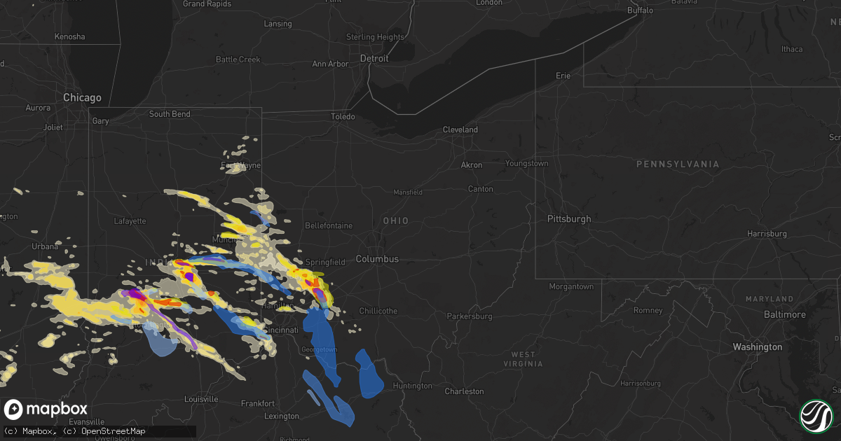
Hail Map in Ohio on June 18, 2021
Get this storm
June 18 map
$229
one time, instant access
Download today. No call, no setup
Keep the $229
Bought the map and want the full workflow? Apply the entire $229 to a subscription within 7 days. None of it is wasted.
Every map, not just this one
This buys you this map. Subscription and you get every map we run, in the markets you choose from a few cities to whole states to nationwide. Plus real-time alerts the moment a storm fires.
Contact data
Name, contact info, occupancy, even credit band for addresses in the footprint. You go from where it hit to who to call.
Become the source they trust
Unlimited branding weather history reports on demand. You already have the documented answer ready for the property owner, and you are the one who showed up with it.
Property data and RoofTrace estimates
Pull up any address you have got, its value and the exact code rules for that jurisdiction, straight from One Click Code. Then RoofTrace estimates the squares, pitch, and roof value, priced the way you price.
Storm reports in Ohio
Ohio
| Date | Description |
|---|---|
| 06/18/20216:55 PM CDT | Report received from mping network |
| 06/18/20216:50 PM CDT | A local report indicates 1.75 inch wind near XENIA |
| 06/18/20216:43 PM CDT | Large tree down. Time estimated by radar. |
| 06/18/20216:39 PM CDT | Tree down over harter road. Time estimated from radar data. |
| 06/18/20216:33 PM CDT | A local report indicates 1.00 inch wind near 3 NNW BELLBROOK |
| 06/18/20216:31 PM CDT | A local report indicates 1.00 inch wind near BEAVERCREEK |
| 06/18/20216:31 PM CDT | A local report indicates 2.50 inch wind near 4 SSW BEAVERCREEK |
| 06/18/20216:30 PM CDT | A local report indicates 1.50 inch wind near 4 SSW BEAVERCREEK |
| 06/18/20216:27 PM CDT | A local report indicates 1.00 inch wind near FAIRBORN |
| 06/18/20216:24 PM CDT | A local report indicates 1.00 inch wind near KETTERING |
| 06/18/20216:20 PM CDT | Several large limbs downed along darby rd. In riverside. Time estimated by radar. |
| 06/18/20216:20 PM CDT | Multiple trees down across road |
| 06/18/20216:15 PM CDT | A local report indicates 1.50 inch wind near RIVERSIDE |
| 06/18/20216:15 PM CDT | A local report indicates 1.00 inch wind near DOWNTOWN DAYTON |
| 06/18/20215:46 PM CDT | A local report indicates 1.00 inch wind near CLAYTON |
| 06/18/20215:08 PM CDT | Damage to vehicles |
| 06/18/20215:00 PM CDT | A local report indicates 1.75 inch wind near TROTWOOD |
| 06/18/20214:59 PM CDT | Tree fell on a house in the town of pitsburg... Oh. Time estimated using radar data. |
| 06/18/20214:56 PM CDT | A local report indicates 1.00 inch wind near 6 NW DOWNTOWN DAYTON |
| 06/18/20213:14 PM CDT | Emergency manager passed on report from local fire department of confirmed tornado northwest of ft. Recovery... Oh at park road and state line road. A tds signature was |
| 06/18/20213:12 PM CDT | Nws storm survey confirms an ef2 tornado with a path length of 5.7 miles. |
| 06/18/202110:09 AM CDT | Multiple large branches down |
| 06/18/20218:30 AM CDT | Trees and power lines reported down in batavia. This was representative across the county. Time estimated from radar. |
| 06/18/20218:25 AM CDT | Porched reported collasped from thunderstorm winds. Time estimate from radar. |
| 06/18/20217:28 AM CDT | Report from mping: trees uprooted or snapped; roof blown off. |
| 06/18/20216:43 AM CDT | At 1142 PM EDT, a severe thunderstorm was located over Morrow, moving east at 35 mph. HAZARD...Quarter size hail. SOURCE...Radar indicated. IMPACT...Minor damage to vehicles is possible. Locations impacted include... Mason, Lebanon, Wilmington, Monroe, Loveland, Blanchester, Lynchburg, New Vienna, Morrow, Kings Island, Russell, South Lebanon, Woodville, Maineville, Clarksville, Goshen, Martinsville, Fayetteville, Midland and Butlerville.This includes I-71 in Ohio between mile markers 20 and 36. |
| 06/18/20216:37 AM CDT | At 1137 AM EDT, a severe thunderstorm was located near Claryville, moving southeast at 30 mph. HAZARD...60 mph wind gusts and quarter size hail. SOURCE...Radar indicated. IMPACT...Minor hail damage to vehicles is possible. Expect wind damage to trees and power lines. Locations impacted include... Independence, Alexandria, Walton, Falmouth, Claryville, Felicity, Butler, Ryland Heights, Mentor, Moscow, Neville, Chilo, Mount Auburn, Visalia, Atwood, Willow Grove, Bradford, Grants Lick, Gubser Mill and Peach Grove. |
| 06/18/20216:03 AM CDT | At 1102 PM EDT, a severe thunderstorm was located over Fairfield, moving east at 35 mph. HAZARD...Quarter size hail. SOURCE...Radar indicated. IMPACT...Minor damage to vehicles is possible. Locations impacted include... Hamilton, Fairfield, Mason, Lebanon, Forest Park, Sharonville, Monroe, Blue Ash, Loveland, Springdale, Reading, Montgomery, Madeira, Wyoming, Milford, Mount Healthy, Deer Park, Finneytown, West Chester and Terrace Park.This includes the following Interstates... I-71 in Ohio between mile markers 11 and 35. I-75 in Ohio between mile markers 11 and 28. |
| 06/18/20215:34 AM CDT | At 1033 PM EDT, severe thunderstorms were located along a line extending from Mount Olivet to Portsmouth, moving southeast at 40 mph. HAZARD...70 mph wind gusts and penny size hail. SOURCE...Radar indicated. IMPACT...Expect considerable tree damage. Damage is likely to mobile homes, roofs, and outbuildings. Locations impacted include... Portsmouth, Maysville, Wheelersburg, New Boston, Vanceburg, Lewisburg, Rosemount, Camp Dix, Rome, Foxport, Head of Grassy, Tollesboro, Sciotodale, Mount Olivet, Sardis, Saint Paul, Burika, Mays Lick, Kinniconick and Rectorville. |
| 06/18/20214:09 AM CDT | At 909 PM EDT, a severe thunderstorm was located over Lynchburg, moving southeast at 30 mph. HAZARD...70 mph wind gusts and quarter size hail. SOURCE...Radar indicated. IMPACT...Minor hail damage to vehicles is possible. Expect considerable tree damage. Wind damage is also likely to mobile homes, roofs, and outbuildings. Locations impacted include... Hillsboro, Blanchester, Mount Orab, Peebles, Lynchburg, New Vienna, Winchester, Marshall, Sardinia, Seaman, Belfast, Rocky Fork Point, Russell, New Market, Emerald, Martinsville, Mowrystown, Fayetteville, Midland and Cherry Fork. |
| 06/18/20213:56 AM CDT | At 856 PM EDT, severe thunderstorms were located along a line extending from near Lawrenceburg to near Versailles, moving southeast at 60 mph. HAZARD...70 mph wind gusts. SOURCE...Radar indicated. IMPACT...Expect considerable tree damage. Damage is likely to mobile homes, roofs, and outbuildings. Locations impacted include... Lawrenceburg, Greendale, Aurora, Walton, Rising Sun, Hidden Valley, Oakbrook, Burlington, Bright, Union, Crittenden, Versailles, Milan, Vevay, Warsaw, Dillsboro, Shawnee, Moores Hill, Florence and Kentucky Speedway.This includes the following Interstates... I-71 in Kentucky between mile markers 55 and 77. I-75 in Kentucky between mile markers 170 and 179. |
| 06/18/20213:51 AM CDT | At 851 PM EDT, a severe thunderstorm was located over Wilmington, moving southeast at 15 mph. HAZARD...70 mph wind gusts and quarter size hail. SOURCE...Radar indicated. IMPACT...Minor hail damage to vehicles is possible. Expect considerable tree damage. Wind damage is also likely to mobile homes, roofs, and outbuildings. Locations impacted include... Wilmington, Sabina, Lynchburg, Leesburg, New Vienna, Russell, Martinsville, Midland, Highland, Melvin, New Antioch, Samantha, Westboro, Cuba, Lees Creek, Reesville, Morrisville, Ogden, Burtonville and Cowan Lake State Park.This includes I-71 in Ohio between mile markers 52 and 53. |
| 06/18/20213:39 AM CDT | At 839 PM EDT, severe thunderstorms were located along a line extending from near Camden to Ross, moving east at 35 mph. HAZARD...60 mph wind gusts. SOURCE...Radar indicated. IMPACT...Expect damage to trees and power lines. Locations impacted include... Hamilton, Kettering, Middletown, Fairfield, Mason, Oxford, Miamisburg, Lebanon, Forest Park, Springboro, Sharonville, Monroe, Blue Ash, Loveland, Trenton, Franklin, Springdale, Reading, Montgomery and Harrison.This includes the following Interstates... I-71 in Ohio between mile markers 16 and 40. I-74 in Ohio between mile markers 3 and 4. I-75 in Ohio between mile markers 13 and 48. |
| 06/18/20213:18 AM CDT | At 817 PM EDT, a severe thunderstorm was located 8 miles northwest of Wilmington, moving southeast at 15 mph. HAZARD...Two inch hail and 70 mph wind gusts. SOURCE...Radar indicated. IMPACT...People and animals outdoors will be injured. Expect hail damage to roofs, siding, windows, and vehicles. Expect considerable tree damage. Wind damage is also likely to mobile homes, roofs, and outbuildings. Locations impacted include... Wilmington, Sabina, New Vienna, Harveysburg, Corwin, Bowersville, Port William, Paintersville, Melvin, Bloomington, Lumberton, Middleton Corner, New Antioch, Oakland, Cuba, Lees Creek, Reesville, Caesar Creek State Park, Morrisville and Ogden.This includes I-71 in Ohio between mile markers 41 and 60. |
| 06/18/20213:11 AM CDT | At 811 PM EDT, a severe thunderstorm was located over Trotwood, moving east at 15 mph. HAZARD...Ping pong ball size hail and 60 mph wind gusts. SOURCE...Radar indicated. IMPACT...People and animals outdoors will be injured. Expect hail damage to roofs, siding, windows, and vehicles. Expect wind damage to trees and power lines. Locations impacted include... Dayton, Kettering, Beavercreek, Huber Heights, Fairborn, Trotwood, Vandalia, Englewood, Moraine, Oakwood, Wright-Patterson Afb, Riverside, Clayton, Union, Brookville, New Lebanon, Shiloh, Phillipsburg, Fort Mckinley and Northview.This includes the following Interstates... I-70 in Ohio between mile markers 22 and 41. I-75 in Ohio between mile markers 49 and 62. |
| 06/18/20212:53 AM CDT | At 753 PM EDT, a severe thunderstorm was located over Xenia, moving southeast at 20 mph. HAZARD...Golf ball size hail and 60 mph wind gusts. SOURCE...Radar indicated. IMPACT...People and animals outdoors will be injured. Expect hail damage to roofs, siding, windows, and vehicles. Expect wind damage to trees and power lines. Locations impacted include... Beavercreek, Xenia, Wilmington, Bellbrook, Cedarville, Sabina, Jamestown, Jeffersonville, Wilberforce, New Jasper, Spring Valley, Bowersville, Port William, Milledgeville, Octa, Paintersville, Melvin, Rosemoor, Lumberton and Mount Holly.This includes I-71 in Ohio between mile markers 48 and 69. |
| 06/18/20212:51 AM CDT | At 750 PM EDT, a severe thunderstorm was located near Hagerstown, moving east at 50 mph. HAZARD...Quarter size hail. SOURCE...Radar indicated. IMPACT...Minor damage to vehicles is possible. Locations impacted include... Richmond, Centerville, Cambridge City, Hagerstown, Fountain City, Dublin, Franklin, Greens Fork, East Germantown, Spring Grove, Bethel, Economy, Boston, Mount Auburn, Whitewater, Richmond Municipal Airport, Middleboro, Jacksonburg, Interstate 70 at Exit 145 and Williamsburg.This includes the following Interstates... I-70 in Indiana between mile markers 134 and 156. I-70 in Ohio near mile marker 0. |
| 06/18/20212:19 AM CDT | At 719 PM EDT, a severe thunderstorm was located near Oakwood, moving southeast at 20 mph. HAZARD...60 mph wind gusts and half dollar size hail. SOURCE...Radar indicated. IMPACT...Minor hail damage to vehicles is possible. Expect wind damage to trees and power lines. Locations impacted include... Dayton, Kettering, Beavercreek, Huber Heights, Fairborn, Xenia, Miamisburg, Bellbrook, Moraine, Oakwood, Yellow Springs, Wright-Patterson Afb, West Carrollton, Cedarville, Jamestown, Wilberforce, Riverside, New Jasper, Spring Valley and Bowersville.This includes the following Interstates... I-71 in Ohio between mile markers 58 and 61. I-75 in Ohio between mile markers 45 and 55. |
| 06/18/20212:13 AM CDT | At 713 PM EDT, a severe thunderstorm was located near Greenville, moving east at 35 mph. HAZARD...60 mph wind gusts and nickel size hail. SOURCE...Trained weather spotters. At 711 pm dime size hail was reported in Palestine. IMPACT...Expect damage to trees and power lines. Locations impacted include... Greenville, Versailles, Arcanum, Bradford, Union City, Ansonia, New Madison, Webster, Wayne Lakes, Gettysburg, Pitsburg, Hollansburg, Palestine, Union Corners, Darke County Airport, Cosmos, Sharpeye, State Route 47 at US Route 127, Abbottsville and Sharps Crossing. |
| 06/18/20211:53 AM CDT | At 653 PM EDT, a severe thunderstorm was located near Winchester, or 13 miles south of Portland, moving southeast at 40 mph. HAZARD...60 mph wind gusts and half dollar size hail. SOURCE...Radar indicated. IMPACT...Hail damage to vehicles is expected. Expect wind damage to roofs, siding, and trees. This severe thunderstorm will be near... Union City around 705 PM EDT. |
| 06/18/20211:39 AM CDT | At 639 PM EDT, a severe thunderstorm was located near Englewood, moving southeast at 20 mph. HAZARD...60 mph wind gusts and half dollar size hail. SOURCE...Radar indicated. IMPACT...Minor hail damage to vehicles is possible. Expect wind damage to trees and power lines. Locations impacted include... Dayton, Kettering, Beavercreek, Huber Heights, Fairborn, Trotwood, Miamisburg, Vandalia, Englewood, Moraine, West Milton, Oakwood, Wright-Patterson Afb, West Carrollton, Riverside, Clayton, Union, Brookville, New Lebanon and Shiloh.This includes the following Interstates... I-70 in Ohio between mile markers 18 and 41. I-75 in Ohio between mile markers 45 and 65. |
| 06/18/202112:57 AM CDT | At 557 PM EDT, a severe thunderstorm was located over Northridge, moving east at 20 mph. HAZARD...60 mph wind gusts and quarter size hail. SOURCE...Radar indicated. IMPACT...Minor hail damage to vehicles is possible. Expect wind damage to trees and power lines. Locations impacted include... Dayton, Kettering, Beavercreek, Huber Heights, Fairborn, Trotwood, Vandalia, Englewood, Moraine, New Carlisle, Oakwood, Yellow Springs, Wright-Patterson Afb, Enon, Riverside, Clayton, Shiloh, Donnelsville, Green Meadows and Fort Mckinley.This includes the following Interstates... I-70 in Ohio between mile markers 27 and 48. I-75 in Ohio between mile markers 51 and 63. |
| 06/18/202112:16 AM CDT | At 515 PM EDT, a severe thunderstorm was located near Winchester, moving southeast at 30 mph. HAZARD...60 mph wind gusts and quarter size hail. SOURCE...Radar indicated. IMPACT...Minor hail damage to vehicles is possible. Expect wind damage to trees and power lines. Locations impacted include... Greenville, Union City, Ansonia, Wayne Lakes, Palestine, Abbottsville, Sharps Crossing, Cosmos, Sharpeye and Pikeville. |
| 06/18/202112:04 AM CDT | At 504 PM EDT, a severe thunderstorm was located near Winchester, or 13 miles south of Portland, moving southeast at 35 mph. HAZARD...60 mph wind gusts and quarter size hail. SOURCE...Radar indicated. IMPACT...Hail damage to vehicles is expected. Expect wind damage to roofs, siding, and trees. This severe thunderstorm will be near... Union City around 515 PM EDT. |
| 06/17/202111:48 PM CDT | At 448 PM EDT, a severe thunderstorm was located near Versailles, moving southeast at 30 mph. HAZARD...60 mph wind gusts. SOURCE...Radar indicated. IMPACT...Expect damage to trees and power lines. Locations impacted include... Piqua, Versailles, Covington, Newport, Bradford, Webster, Russia, Osgood, North Star, Lockington, Yorkshire, Polo, Bloomer, Darke County Airport, Brock, Eldora Speedway, Willowdell, Horatio and Houston.This includes I-75 in Ohio between mile markers 83 and 87. |
| 06/17/202111:48 PM CDT | At 448 PM EDT, a severe thunderstorm was located near Redkey, or 7 miles southeast of Dunkirk, moving east at 45 mph. HAZARD...60 mph wind gusts and quarter size hail. SOURCE...Radar indicated. IMPACT...Hail damage to vehicles is expected. Expect wind damage to roofs, siding, and trees. Locations impacted include... Redkey, Salamonia, Boundary City, Collett, Bluff Point, Powers, New Mount Pleasant and Como. |
| 06/17/202111:26 PM CDT | At 426 PM EDT, a severe thunderstorm was located over Albany, or near Dunkirk, moving southeast at 35 mph. HAZARD...60 mph wind gusts and quarter size hail. SOURCE...Radar indicated. IMPACT...Hail damage to vehicles is expected. Expect wind damage to roofs, siding, and trees. This severe thunderstorm will be near... Albany around 430 PM EDT. Farmland around 445 PM EDT.Other locations in the path of this severe thunderstorm includeRidgeville, Winchester, Union City and Saratoga. |
| 06/17/202111:16 PM CDT | At 416 PM EDT, a severe thunderstorm was located 8 miles south of Portland, moving east at 40 mph. HAZARD...60 mph wind gusts and quarter size hail. SOURCE...Radar indicated. IMPACT...Hail damage to vehicles is expected. Expect wind damage to roofs, siding, and trees. Locations impacted include... Salamonia, Bluff Point, Boundary City and Collett. |
| 06/17/202110:47 PM CDT | At 347 PM EDT, a severe thunderstorm was located over Geneva, moving east at 25 mph. HAZARD...60 mph wind gusts and quarter size hail. SOURCE...Radar indicated. IMPACT...Minor hail damage to vehicles is possible. Expect wind damage to trees and power lines. Locations impacted include... Celina, Coldwater, St. Henry, Rockford, Wabash, Mendon, Montezuma, Chattanooga, Carthagena and Tama. |
| 06/17/202110:34 PM CDT | At 333 PM EDT, a severe thunderstorm was located near Berne, moving east at 35 mph. HAZARD...60 mph wind gusts and half dollar size hail. SOURCE...Radar indicated. IMPACT...Hail damage to vehicles is expected. Expect wind damage to roofs, siding, and trees. Locations impacted include... Berne, Geneva, Westchester, Nottingham, Bryant, Vera Cruz, Trinity, Ceylon, Reiffsburg, Petroleum, Linn Grove, Domestic, New Corydon and Fiat. |
| 06/17/202110:27 PM CDT | At 327 PM EDT, a severe thunderstorm was located near Albany, or near Muncie, moving east at 45 mph. HAZARD...60 mph wind gusts and quarter size hail. SOURCE...Radar indicated. IMPACT...Hail damage to vehicles is expected. Expect wind damage to roofs, siding, and trees. This severe thunderstorm will be near... Albany around 330 PM EDT. Parker City around 335 PM EDT. Farmland around 340 PM EDT. Ridgeville around 345 PM EDT.Other locations in the path of this severe thunderstorm includeWinchester, Saratoga and Union City. |
| 06/17/202110:18 PM CDT | A local report indicates 1.00 inch wind near WEST CHESTER |
| 06/17/20218:53 PM CDT | Several trees down on cooper road near appleton road. Time estimated from radar data. |
| 06/17/20218:46 PM CDT | Trees and power lines reported down. Time estimated from radar. |
| 06/17/20218:36 PM CDT | Large healthy branch broken off a tree at a property on judd road. Time of event estimated from radar. |
| 06/17/20218:30 PM CDT | Trees and power lines reported down in batavia. This was representative across the county. Time estimated from radar. |
| 06/17/20218:25 PM CDT | Porched reported collasped from thunderstorm winds. Time estimate from radar. |
| 06/17/20218:11 PM CDT | Healthy tree snapped and fell on top of a car. Time estimated from radar data. |
| 06/17/20218:11 PM CDT | Large tree uprooted. Time estimated by radar. |
| 06/17/20218:10 PM CDT | Substantial tree damage and downed silo on rhude road. Time estimated from radar. |
| 06/17/20218:10 PM CDT | Large trees snapped at base on second creek road. Time estimated from radar. |
| 06/17/20218:09 PM CDT | One tree uprooted at a property on vandervoort road. Time estimated from radar. |
| 06/17/20218:05 PM CDT | One tree down at a property on mccully lane. Time estimated from radar. |
| 06/17/20218:04 PM CDT | Tree downed across brewer road near the intersection with crooked tree drive. Time estimated from radar. |
| 06/17/20218:00 PM CDT | Several large branches downed on edwardsville road. Time estimated from radar. |
| 06/17/20217:57 PM CDT | A local report indicates 70 MPH wind near 2 SSE WILMINGTON |
| 06/17/20217:57 PM CDT | Large branches downed on templin road. Time estimated from radar. |
| 06/17/20217:52 PM CDT | Large tree snapped at the corner of allen rd. And worthington rd. Tree debris through area. Time estimated by radar. |
| 06/17/20217:52 PM CDT | Large limbs downed across state route 132 north of state route 133. Time estimated from radar. |
| 06/17/20217:52 PM CDT | Multiple trees down |
| 06/17/20217:51 PM CDT | Large limbs downed across state route 132 south of pansy road. Time estimated from radar. |
| 06/17/20217:48 PM CDT | A local report indicates 60 MPH wind near KILN WILMINGTON APT |
| 06/17/20217:45 PM CDT | Large tree downed along oregnia road between waynesville road and hollingsworth rd. Time of event estimated. |
| 06/17/20217:45 PM CDT | Trees down |
| 06/17/20217:42 PM CDT | Tree downed across clarksville road south of beechgrove road. Time estimated from radar. |
| 06/17/20217:40 PM CDT | Large tree limb downed on south main street in miamisburg. Time estimated by radar. |
| 06/17/20217:40 PM CDT | Six large and several smaller trees blown down. |
| 06/17/20217:39 PM CDT | Widespread tree damage in the massie township area... Especially near sherod road and harveysburg road. One house had two windows blown in. Time estimated from radar. |
| 06/17/20217:38 PM CDT | Nws storm survey confirms an ef1 tornado with a path length of 2.8 miles. Damage mostly to trees with minor roof damage to a home and a barn. |
| 06/17/20217:34 PM CDT | Tree downed at a property on us route 22 near nelson ave. Time estimated from radar. |
| 06/17/20217:33 PM CDT | Large limbs downed across us route 22 near megan drive. Time estimated from radar. |
| 06/17/20217:33 PM CDT | Large limbs downed across us route 22 near hale road and near ogden road. Time estimated from radar. |
| 06/17/20217:33 PM CDT | A local report indicates 1.25 inch wind near 4 S TROTWOOD |
| 06/17/20217:30 PM CDT | Tree branches and trim of house down. Time estimated from radar. |
| 06/17/20217:25 PM CDT | Trees and power lines reported down in eaton. Time estimated from radar. |
All States Impacted by Hail Map on June 18, 2021
Cities Impacted by Hail Map on June 18, 2021
- Vandalia, OH
- West Milton, OH
- Troy, OH
- Tipp City, OH
- Malvern, IA
- Silver City, IA
- Seymour, IN
- Albin, WY
- Pine Bluffs, WY
- Burns, WY
- Bowling Green, IN
- Coal City, IN
- Clay City, IN
- Terre Haute, IN
- Poland, IN
- Brazil, IN
- Freedom, IN
- Riley, IN
- Patricksburg, IN
- Spencer, IN
- Cory, IN
- Centerpoint, IN
- Greensburg, IN
- Saint Charles, IA
- Indianola, IA
- Prole, IA
- Saint Marys, IA
- Keota, IA
- West Chester, IA
- Washington, IA
- Wellman, IA
- Bussey, IA
- Cantril, IA
- Red Oak, IA
- Wyaconda, MO
- Macedonia, IA
- Centerville, IA
- Pulaski, IA
- Ackworth, IA
- Murray, IA
- Fontanelle, IA
- Griswold, IA
- Lewis, IA
- Peru, IA
- Corydon, IA
- Kahoka, MO
- Drakesville, IA
- Greenfield, IA
- Lacona, IA
- Woodburn, IA
- Truro, IA
- Ursa, IL
- Walnut, IA
- Avoca, IA
- Mystic, IA
- Cumberland, IA
- Stuart, IA
- Lucas, IA
- Alexandria, MO
- Anita, IA
- Mendon, IL
- Moulton, IA
- Winterset, IA
- Humeston, IA
- Downing, MO
- Wiota, IA
- Luray, MO
- Milton, IA
- Afton, IA
- Dexter, IA
- Albia, IA
- Villisca, IA
- Corning, IA
- Blakesburg, IA
- Moravia, IA
- Lorimor, IA
- Plano, IA
- Warsaw, IL
- Arbela, MO
- Atlantic, IA
- Creston, IA
- Orient, IA
- Melrose, IA
- Oakland, IA
- Memphis, MO
- Udell, IA
- Carson, IA
- Massena, IA
- West Point, IL
- Unionville, IA
- New Virginia, IA
- Elliott, IA
- Milo, IA
- Chariton, IA
- Osceola, IA
- Sutter, IL
- Millerton, IA
- Gorin, MO
- Macksburg, IA
- Adair, IA
- Russell, IA
- Derby, IA
- Bridgewater, IA
- Wayland, MO
- Casey, IA
- Canton, MO
- Treynor, IA
- Saint Patrick, MO
- Menlo, IA
- Bloomfield, IA
- Grant, IA
- Henderson, IA
- Promise City, IA
- Hancock, IA
- Columbus, IN
- Stinesville, IN
- Madison, IN
- Worthington, IN
- Tuscola, IL
- Reelsville, IN
- Nineveh, IN
- Lewis, IN
- Redmon, IL
- Stilesville, IN
- West Terre Haute, IN
- Philo, IL
- Commiskey, IN
- Morgantown, IN
- Nashville, IN
- Martinsville, IN
- Villa Grove, IL
- Deputy, IN
- Lexington, IN
- Campbellsburg, KY
- Bedford, KY
- Paris Crossing, IN
- Martinsville, IL
- West Union, IL
- Longview, IL
- Gosport, IN
- North Vernon, IN
- Arcola, IL
- Monrovia, IN
- Dennison, IL
- Austin, IN
- Trafalgar, IN
- Jasonville, IN
- Tolono, IL
- Hindsboro, IL
- Charleston, IL
- Newman, IL
- Ellettsville, IN
- Paragon, IN
- Camargo, IL
- Freetown, IN
- Kansas, IL
- Shelburn, IN
- Marshall, IL
- Westfield, IL
- Farmersburg, IN
- Edinburgh, IN
- Hymera, IN
- Franklin, IN
- Brocton, IL
- Ashmore, IL
- Greencastle, IN
- Fillmore, IN
- Hanover, IN
- Quincy, IN
- Milton, KY
- Pimento, IN
- Cloverdale, IN
- Oakland, IL
- Mooresville, IN
- Crothersville, IN
- Casey, IL
- Paris, IL
- Bargersville, IN
- Pesotum, IL
- Bloomington, IN
- Unionville, IN
- Coatesville, IN
- Clayton, IN
- Sadorus, IL
- Hume, IL
- Murdock, IL
- Valders, WI
- Neenah, WI
- Reedsville, WI
- Menasha, WI
- Brillion, WI
- Stockbridge, WI
- Chilton, WI
- Oshkosh, WI
- Kiel, WI
- Hilbert, WI
- Eaton, OH
- Dayton, OH
- Miamisburg, OH
- Springboro, OH
- Richmond, IN
- New Paris, OH
- New Madison, OH
- Fountain City, IN
- Hollansburg, OH
- Blackduck, MN
- Pennington, MN
- Bemidji, MN
- Knoxville, IA
- Pella, IA
- Alliance, NE
- Fairbury, NE
- Farina, IL
- Pacific Junction, IA
- Van Meter, IA
- Norwalk, IA
- Cumming, IA
- Keosauqua, IA
- Farmington, IA
- Bonaparte, IA
- Donnellson, IA
- Fort Madison, IA
- West Point, IA
- Lawrenceburg, IN
- Petersburg, KY
- Indianapolis, IN
- Marion, WI
- Hemingford, NE
- Harrison, NE
- Fairland, IN
- Fountaintown, IN
- Lovilia, IA
- Dunkirk, IN
- Redkey, IN
- Eaton, IN
- Albany, IN
- Portland, IN
- Ridgeville, IN
- Mccordsville, IN
- Greenfield, IN
- New Palestine, IN
- London Mills, IL
- Maquon, IL
- Saint Augustine, IL
- Abingdon, IL
- Gilson, IL
- Quincy, IL
- Payson, IL
- Liberty, IL
- Plainville, IL
- Pleasantville, IA
- Anderson, IN
- Oskaloosa, IA
- Monmouth, IL
- Morning Sun, IA
- Berwick, IL
- Canton, IL
- Burlington, IA
- Cuba, IL
- Oakville, IA
- Pekin, IL
- Hanna City, IL
- Green Valley, IL
- Oquawka, IL
- Little York, IL
- Danvers, IL
- Tremont, IL
- Minier, IL
- Delavan, IL
- Farmington, IL
- Shirley, IL
- Bloomington, IL
- Glasford, IL
- Yates City, IL
- Trivoli, IL
- Aledo, IL
- Hopedale, IL
- McLean, IL
- Stanford, IL
- Mediapolis, IA
- Knoxville, IL
- South Pekin, IL
- Seaton, IL
- Groveland, IL
- Cameron, IL
- Keithsburg, IL
- Avon, IL
- Kingston Mines, IL
- Norris, IL
- Ellisville, IL
- Galesburg, IL
- Elmwood, IL
- Gerlaw, IL
- Peoria, IL
- Biggsville, IL
- Kirkwood, IL
- Gladstone, IL
- Sperry, IA
- Morton, IL
- Alexis, IL
- Fairview, IL
- Mapleton, IL
- Saint David, IL
- Joy, IL
- Manito, IL
- Mackinaw, IL
- Muncie, IN
- Markleville, IN
- New Castle, IN
- Shirley, IN
- Wilkinson, IN
- Arthur, IL
- Lovington, IL
- Atwood, IL
- Pine River, WI
- Fremont, WI
- Oldenburg, IN
- Waynesville, OH
- Catlin, IL
- Oakwood, IL
- Lerna, IL
- Fairfield, IA
- Brighton, IA
- Middletown, IN
- Kennard, IN
- Pendleton, IN
- Connersville, IN
- Germantown, OH
- Ohiowa, NE
- Alexandria, NE
- Daykin, NE
- Tobias, NE
- Liberty, IN
- Shelbyville, IN
- Rushville, IN
- Manilla, IN
- Milroy, IN
- Waldron, IN
- Sumner, IL
- Cheyenne, WY
- Carpenter, WY
- Oblong, IL
- Ottumwa, IA
- Eddyville, IA
- Winchester, IN
- Farmland, IN
- New London, IA
- Danville, IA
- West Burlington, IA
- Salem, IA
- Middletown, IA
- Wever, IA
- Trenton, OH
- Hamilton, OH
- Cleves, OH
- Miamitown, OH
- Cincinnati, OH
- Wilmington, OH
- Williamsburg, IN
- Iuka, IL
- Winfield, IA
- Columbus City, IA
- Columbus Junction, IA
- Ainsworth, IA
- Crawfordsville, IA
- Wapello, IA
- Springport, IN
- Mooreland, IN
- Daleville, IN
- Springfield, IL
- Pleasant Plains, IL
- Kalona, IA
- Bridgeport, IL
- Minonk, IL
- Fairbury, IL
- Chenoa, IL
- Pontiac, IL
- Weldon, IA
- Leon, IA
- Hillsboro, OH
- Peebles, OH
- Latham, OH
- Milwaukee, WI
- Lockridge, IA
- Council Bluffs, IA
- Clintonville, WI
- Shiocton, WI
- Jansen, NE
- Diller, NE
- Fe Warren Afb, WY
- Union City, OH
- Union City, IN
- Eldon, IA
- Selma, IA
- Floris, IA
- Warren, IN
- Poneto, IN
- Liverpool, IL
- Lewistown, IL
- Arenzville, IL
- Rushville, IL
- Frederick, IL
- Mount Sterling, IL
- Beardstown, IL
- Virginia, IL
- Loami, IL
- New Berlin, IL
- Claremont, IL
- Arcanum, OH
- Fairborn, OH
- Clayton, OH
- Englewood, OH
- Brookville, OH
- Bellbrook, OH
- Spring Valley, OH
- Xenia, OH
- Branson, CO
- Mount Union, IA
- Marion, IN
- Saint Paul, IN
- Wabash, IN
- Bradford, OH
- Yorkshire, OH
- Centerville, IN
- Logansport, IN
- Brooklyn, IN
- Hartford City, IN
- Maria Stein, OH
- Jamestown, OH
- Carrollton, KY
- Boggstown, IN
- Beech Grove, IN
- Brookville, IN
- Ingalls, IN
- Greens Fork, IN
- Modoc, IN
- Ivesdale, IL
- Lynn, IN
- Alpha, OH
- Phillipsburg, OH
- Verona, OH
- Greenup, IL
- Rockford, OH
- Farmersville, OH
- Fishers, IN
- Peru, IN
- New Waverly, IN
- Zionsville, IN
- Sunman, IN
- Scottsburg, IN
- Laurel, IN
- Celina, OH
- West Newton, IN
- Eldorado, OH
- Bluffton, IN
- Greenwood, IN
- Hope, IN
- Fortville, IN
- Berne, IN
- Saint Henry, OH
- Sabina, OH
- Geneva, IN
- West York, IL
- Pittsboro, IN
- Morristown, IN
- Dupont, IN
- Walton, IN
- Palestine, OH
- New Weston, OH
- Bloomfield, IN
- Indianola, IL
- West Manchester, OH
- Brownsburg, IN
- Parker City, IN
- Whiteland, IN
- Broadlands, IL
- Wilberforce, OH
- Bryant, IN
- Upland, IN
- Knightstown, IN
- Economy, IN
- Hammond, IL
- Pitsburg, OH
- Plainfield, IN
- Ansonia, OH
- West Alexandria, OH
- Decatur, IL
- Staunton, IN
- Keystone, IN
- Chrisman, IL
- Ridge Farm, IL
- Batesville, IN
- Argenta, IL
- Bement, IL
- Norman, IN
- Annapolis, IL
- Oreana, IL
- Sidell, IL
- Pleasureville, KY
- New Vienna, OH
- Hutsonville, IL
- Allerton, IL
- Selma, IN
- Harmony, IN
- Straughn, IN
- Greenville, OH
- Cerro Gordo, IL
- Leesburg, OH
- La Fontaine, IN
- Coalmont, IN
- Camden, OH
- Cambridge City, IN
- Flat Rock, IN
- Losantville, IN
- Lewisburg, OH
- Carmel, IN
- Solsberry, IN
- Camby, IN
- Metcalf, IL
- Rossburg, OH
- La Place, IL
- Webster, IN
- Versailles, OH
- New Lebanon, OH
- Turners Station, KY
- Saratoga, IN
- Franklin, OH
- Hagerstown, IN
- Fairbanks, IN
- Laura, OH
- Covington, OH
- Port William, OH
- Needham, IN
- Brownstown, IN
- Coldwater, OH
- Knightsville, IN
- Fort Recovery, OH
- Golden, IL
- Loraine, IL
- Camp Point, IL
- Westfield, IN
- Delta, IA
- Rose Hill, IA
- Fremont, IA
- Hedrick, IA
- Lamar, CO
- Noblesville, IN
- Plattsmouth, NE
- Novelty, MO
- Chatham, IL
- Alexander, IL
- Guilford, IN
- Aurora, IN
- Milan, IN
- Jacksonville, IL
- Ashland, IL
- La Harpe, IL
- Blandinsville, IL
- Brownstown, IL
- Kinmundy, IL
- Harvey, IA
- Burlington, KY
- Lizton, IN
- Edgewood, IL
- Columbia, IA
- Cedar, IA
- Ollie, IA
- Verona, KY
- Warsaw, KY
- Glencoe, KY
- Dry Ridge, KY
- Auburn, IN
- Garrett, IN
- Laotto, IN
- Sullivan, IN
- Saint Elmo, IL
- Beecher City, IL
- Plainville, IN
- Washington, IN
- Mt Zion, IL
- What Cheer, IA
- Sigourney, IA
- Newton, IL
- Trilla, IL
- Mattoon, IL
- Vandalia, IL
- Ramsey, IL
- Texico, IL
- Kell, IL
- Xenia, IL
- Salem, IL
- Johnsonville, IL
- Wayland, IA
- Mount Pleasant, IA
- Strasburg, IL
- Shelbyville, IL
- La Grange, MO
- Fowler, IL
- Flat Rock, IL
- Melcher Dallas, IA
- Mason, OH
- South Lebanon, OH
- Morrow, OH
- Maineville, OH
- Blanchester, OH
- Kings Mills, OH
- Lebanon, OH
- Pleasant Plain, OH
- Glenwood, IA
- Livonia, MO
- Smithfield, IL
- Roseville, IL
- Yarmouth, IA
- Watseka, IL
- Sheldon, IL
- Tipton, IN
- Lawrenceville, IL
- Sheridan, IN
- Cicero, IN
- Arcadia, IN
- Greenfield, OH
- Larsen, WI
- Waupaca, WI
- Winneconne, WI
- Wild Rose, WI
- Walton, KY
- Crittenden, KY
- Morning View, KY
- Chapin, IL
- Concord, IL
- Coatsburg, IL
- Brownsville, IN
- Columbia City, IN
- Churubusco, IN
- Hebron, KY
- Florence, KY
- North Bend, OH
- Union, KY
- Willow Hill, IL
- Lapel, IN
- Hortonville, WI
- New London, WI
- Butler, IN
- Cantrall, IL
- Harper, IA
- Riverside, IA
- Camden, IL
- Timewell, IL
- Clayton, IL
- Huntsville, IL
- Chandlerville, IL
- Shobonier, IL
- West Chester, OH
- Hines, MN
- Olney, IL
- West Salem, IL
- Calhoun, IL
- Mount Carmel, IL
- Parkersburg, IL
- Leo, IN
- Huntertown, IN
- Fort Wayne, IN
- Lomax, IL
- Dallas City, IL
- Carthage, IL
- Dugger, IN
- Linton, IN
- Mechanicsburg, IL
- Rochester, IL
- Riverton, IL
- Tallula, IL
- Dawson, IL
- Forrest, IL
- Elizabethtown, IN
- Waterloo, WI
- Converse, IN
- Carlisle, IN
- North Prairie, WI
- Mukwonago, WI
- Waterloo, IN
- Garden Grove, IA
- East Peoria, IL
- Saint Joseph, IL
- Ogden, IL
- Kimberly, WI
- Appleton, WI
- Montgomery, IN
- Decatur, IN
- Ohio City, OH
- Roachdale, IN
- North Salem, IN
- West Liberty, IL
- Oxford, OH
- Fairmount, IL
- Mount Vernon, IL
- Woodlawn, IL
- Dix, IL
- Bluford, IL
- Clarksville, OH
- Milton, IN
- Bainbridge, OH
- Whitestown, IN
- Ladoga, IN
- New Ross, IN
- Crawfordsville, IN
- Chalmers, IN
- Reynolds, IN
- Roanoke, IN
- Brooksville, KY
- Foster, KY
- Odell, NE
- Monroe, IN
- Sandborn, IN
- Westphalia, IN
- Elnora, IN
- Tracy, IA
- Rosedale, IN
- Seymour, IA
- Willshire, OH
- Saint Peter, IL
- Independence, KY
- Patriot, IN
- Florence, IN
- Bennington, IN
- Osgood, IN
- Hooven, OH
- West Harrison, IN
- Moores Hill, IN
- Dillsboro, IN
- Rising Sun, IN
- Collins, WI
- Erlanger, KY
- Robinson, IL
- Heyworth, IL
- Fithian, IL
- Danville, IN
- Amo, IN
- Yale, IL
- Hamilton, IA
- Yoder, IN
- Fairfield, OH
- Bingham, IL
- Beatrice, NE
- Shickley, NE
- Bruning, NE
- Strang, NE
- Blue Springs, NE
- College Corner, OH
- Fisher, IL
- Mahomet, IL
- Dewey, IL
- Somerville, OH
- Middletown, OH
- Bainbridge, IN
- Charlottesville, IN
- Carthage, IN
- Oregonia, OH
- Lynchburg, OH
- Martinsville, OH
- New Trenton, IN
- Oaktown, IN
- Edwardsport, IN
- Bicknell, IN
- Argyle, IA
- Exline, IA
- Hayesville, IA
- Williamstown, MO
- East Galesburg, IL
- Monticello, MO
- Rutledge, MO
- Paloma, IL
- Montrose, IA
- Ewing, MO
- Leighton, IA
- Patterson, IA
- Bevington, IA
- New Boston, IL
- Armington, IL
- Douds, IA
- Emerson, IA
- Earlham, IA
- Olds, IA
- Minden, IA
- Maywood, MO
- North Henderson, IL
- Mount Sterling, IA
- Bellevue, NE
- Revere, MO
- South English, IA
- Cincinnati, IA
- Saint Francisville, IL
- Allerton, IA
- New Bremen, OH
- Minster, OH
- Sidney, IL
- Cedar Grove, IN
- Okeana, OH
- Sparta, KY
- Normal, IL
- Carlock, IL
- Grover, CO
- Fayetteville, OH
- Aberdeen, OH
- Bethel, OH
- Winchester, OH
- Wallingford, KY
- Hamersville, OH
- Sardinia, OH
- Owensville, OH
- Ripley, OH
- Mayslick, KY
- Augusta, KY
- Dover, KY
- Manchester, OH
- Vanceburg, KY
- Russellville, OH
- Flemingsburg, KY
- Goshen, OH
- Batavia, OH
- Georgetown, OH
- West Union, OH
- Mount Orab, OH
- Williamsburg, OH
- Midland, OH
- Maysville, KY
- Tollesboro, KY
- Emerson, KY
- Blue Creek, OH
- Stout, OH
- Greenup, KY
- Olive Hill, KY
- South Shore, KY
- Garrison, KY
- Argillite, KY
- West Portsmouth, OH
- South Portsmouth, KY
- Friendship, OH
- Quincy, KY
- Otway, OH
- Grayson, KY
- Owingsville, KY
- Moorefield, KY
- Morehead, KY
- Olympia, KY
- West Liberty, KY
- Ezel, KY
- Ewing, KY
- Germantown, KY
- Frenchburg, KY
- Hillsboro, KY
- Mount Olivet, KY
- Salt Lick, KY
- Clearfield, KY
- Wellington, KY
- Carlisle, KY
- Sharpsburg, KY
- Mineola, IA
- Yellow Springs, OH
- Cedarville, OH
- Spiceland, IN
- Lewisville, IN
- Versailles, IN
- Napoleon, IN
- Springville, IN
- Avoca, IN
- Medora, IN
- Oolitic, IN
- Bedford, IN
- Heltonville, IN
- Squaw Lake, MN
- Putnamville, IN
- Homer, IN


