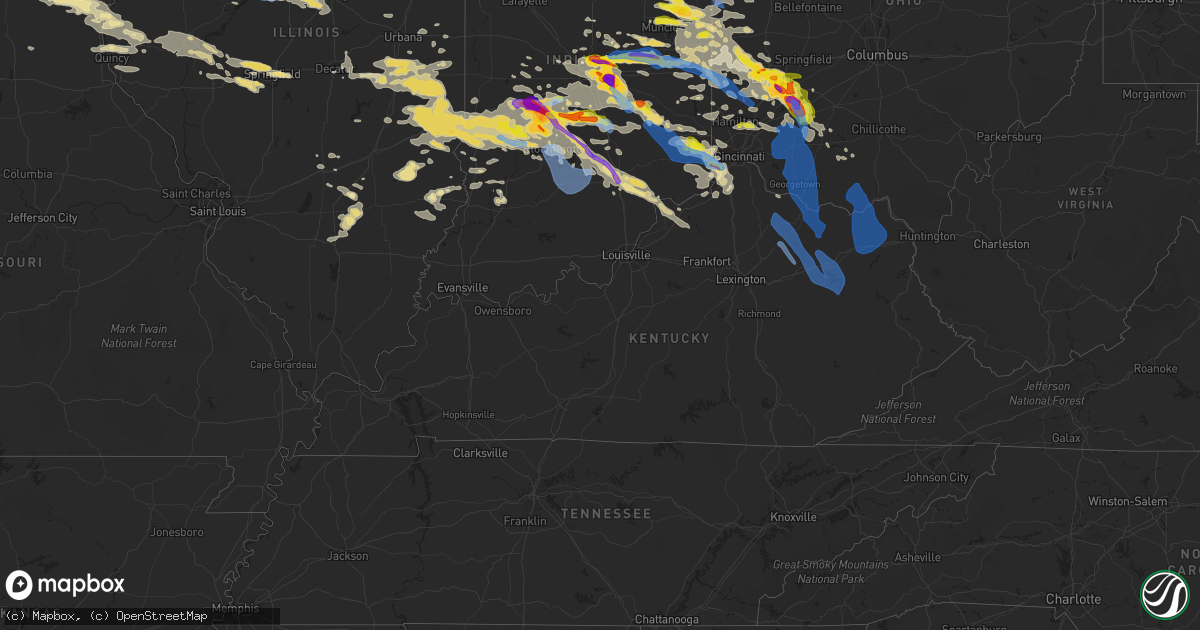
Hail Map in Kentucky on June 18, 2021
Get this storm
June 18 map
$229
one time, instant access
Download today. No call, no setup
Keep the $229
Bought the map and want the full workflow? Apply the entire $229 to a subscription within 7 days. None of it is wasted.
Every map, not just this one
This buys you this map. Subscription and you get every map we run, in the markets you choose from a few cities to whole states to nationwide. Plus real-time alerts the moment a storm fires.
Contact data
Name, contact info, occupancy, even credit band for addresses in the footprint. You go from where it hit to who to call.
Become the source they trust
Unlimited branding weather history reports on demand. You already have the documented answer ready for the property owner, and you are the one who showed up with it.
Property data and RoofTrace estimates
Pull up any address you have got, its value and the exact code rules for that jurisdiction, straight from One Click Code. Then RoofTrace estimates the squares, pitch, and roof value, priced the way you price.
Storm reports in Kentucky
Kentucky
| Date | Description |
|---|---|
| 06/18/202110:45 AM CDT | A local report indicates 1.75 inch wind near BURLINGTON |
| 06/18/202110:26 AM CDT | A local report indicates 1.00 inch wind near BURLINGTON |
| 06/18/202110:25 AM CDT | A local report indicates 1.00 inch wind near BURLINGTON |
| 06/18/20216:27 AM CDT | At 1127 PM EDT, a severe thunderstorm was located 10 miles south of Vernon, moving southeast at 30 mph. HAZARD...60 mph wind gusts and quarter size hail. SOURCE...Radar indicated. IMPACT...Hail damage to vehicles is expected. Expect wind damage to roofs, siding, and trees. This severe thunderstorm will be near... Madison around 1145 PM EDT. |
| 06/18/20216:25 AM CDT | At 1125 PM EDT, a severe thunderstorm was located over Pomp, or near West Liberty, moving southeast at 55 mph. HAZARD...60 mph wind gusts and penny size hail. SOURCE...Radar indicated. IMPACT...Expect damage to roofs, siding, and trees. This severe thunderstorm will be near... Lenox around 1130 PM EDT. Florress around 1135 PM EDT. Cisco around 1140 PM EDT. Perlie around 1145 PM EDT.Other locations in the path of this severe thunderstorm includeSalyersville and Ivyton. |
| 06/18/20215:56 AM CDT | At 1056 PM EDT, a severe thunderstorm was located over Slate Valley, or near Owingsville, moving southeast at 45 mph. HAZARD...60 mph wind gusts and penny size hail. SOURCE...Radar indicated. IMPACT...Expect damage to roofs, siding, and trees. This severe thunderstorm will be near... Marshall around 1100 PM EDT. Salt Lick around 1105 PM EDT. Young Springs around 1110 PM EDT. Yale around 1115 PM EDT.Other locations in the path of this severe thunderstorm include BigWoods and Kellacey. |
| 06/18/20215:24 AM CDT | At 1023 PM EDT, a severe thunderstorm was located over Fairview, or 11 miles west of Flemingsburg, moving southeast at 55 mph. HAZARD...70 mph wind gusts and penny size hail. SOURCE...Radar indicated. IMPACT...Expect considerable tree damage. Damage is likely to mobile homes, roofs, and outbuildings. This severe thunderstorm will be near... Nepton around 1030 PM EDT. Pecks Ridge around 1035 PM EDT. Tilton around 1040 PM EDT.Other locations in the path of this severe thunderstorm includeHillsboro, Grange City and Ramey. |
| 06/18/20214:56 AM CDT | At 956 PM EDT, a severe thunderstorm was located 7 miles southeast of Williamstown, moving southeast at 50 mph. HAZARD...60 mph wind gusts. SOURCE...Radar indicated. IMPACT...Expect damage to roofs, siding, and trees. This severe thunderstorm will be near... Cynthiana around 1015 PM EDT. |
| 06/18/20214:49 AM CDT | At 948 PM EDT, severe thunderstorms were located along a line extending from Seaman to near Felicity, moving southeast at 50 mph. HAZARD...70 mph wind gusts and penny size hail. SOURCE...Radar indicated. IMPACT...Expect considerable tree damage. Damage is likely to mobile homes, roofs, and outbuildings. Locations impacted include... Portsmouth, Maysville, Georgetown, Falmouth, Claryville, Washington, West Union, Manchester, Peebles, Ripley, Aberdeen, Vanceburg, Augusta, Winchester, Seaman, Felicity, Lewisburg, Brooksville, Butler and Camp Dix. |
| 06/18/20214:23 AM CDT | At 922 PM EDT, severe thunderstorms were located along a line extending from Union to near Florence, moving southeast at 45 mph. HAZARD...70 mph wind gusts. SOURCE...Radar indicated. IMPACT...Expect considerable tree damage. Damage is likely to mobile homes, roofs, and outbuildings. Locations impacted include... Independence, Williamstown, Walton, Falmouth, Crittenden, Dry Ridge, Butler, Morgan, Glencoe, Corinth, Sparta, Browning Corner, Stewartsville, Elk Lake, Atwood, Northcutt, Natlee, Bracht, Gardnersville and Fiskburg.This includes I-75 in Kentucky between mile markers 144 and 169. |
| 06/18/20214:15 AM CDT | At 915 PM EDT, a severe thunderstorm was located near Blanchester, moving southeast at 50 mph. HAZARD...60 mph wind gusts and quarter size hail. SOURCE...Radar indicated. IMPACT...Minor hail damage to vehicles is possible. Expect wind damage to trees and power lines. Locations impacted include... Cincinnati, Mason, Sharonville, Blue Ash, Loveland, Reading, Montgomery, Madeira, Alexandria, Milford, Deer Park, Georgetown, Blanchester, Forestville, Claryville, Amelia, Mount Orab, Mariemont, Bethel and New Richmond.This includes I-71 in Ohio between mile markers 10 and 22. |
| 06/18/20213:10 AM CDT | At 809 PM EDT, a severe thunderstorm was located near Milan, moving east at 30 mph. HAZARD...60 mph wind gusts and quarter size hail. SOURCE...Radar indicated. IMPACT...Minor hail damage to vehicles is possible. Expect wind damage to trees and power lines. Locations impacted include... Cincinnati, Harrison, Batesville, Lawrenceburg, Greendale, Bright, Hidden Valley, Cleves, Shawnee, Taylor Creek, Miami Heights, Blue Jay, Mack, Guilford, Logan, Manchester, New Haven, Grandview, Sunman and Addyston.This includes the following Interstates... I-74 in Indiana between mile markers 151 and 171. I-74 in Ohio between mile markers 0 and 9. |
| 06/17/202111:00 PM CDT | Corrects previous tstm wnd dmg report from bradley. Large tree blown down. |
| 06/17/202110:59 PM CDT | A large tree limb was blown down onto ky highway 30. The time of the event is estimated from radar data. |
| 06/17/202110:45 PM CDT | Large tree blown down. |
| 06/17/202110:36 PM CDT | Trees reported down at the intersection of hwy 437 and hwy 172. Time estimated from radar. |
| 06/17/202110:34 PM CDT | Trees reported down on laurel rd near elliottville. |
| 06/17/202110:06 PM CDT | Reported trees down on n wilson ave. |
| 06/17/20219:49 PM CDT | Numerous trees down across roads throughout lewis county.time estimated from radar data. |
| 06/17/20219:42 PM CDT | Tree reported down. Time estimated from radar. |
| 06/17/20219:37 PM CDT | Trees reported down along wooley rd and dudley hollow rd. Time estimated from radar. |
| 06/17/20219:26 PM CDT | Gust reported in 1035 pm observation. Exact time of gust estimated based on radar. |
| 06/17/20219:15 PM CDT | Numerous trees and power poles down east of maysville along kentucky 8 and 10. |
| 06/17/20218:53 PM CDT | Numerous trees reported down across the county. Time estimated using radar data. |
| 06/17/20218:32 PM CDT | Widespread tree damage throughout hebron... Including along camp ernst road. Time estimated by radar. |
| 06/17/20218:32 PM CDT | Trees downed in thunder ridge subdivision. Time estimated by radar. |
| 06/17/20218:32 PM CDT | Trees were blown down near exit 171 of i-75 |
| 06/17/20218:30 PM CDT | Several trees blown down in boone county arboretum. Time estimated from radar. |
| 06/17/20218:18 PM CDT | Numerous trees down on petersburg/belleview road. |
| 06/17/20218:12 PM CDT | Several large trees downed and a barn damaged. Time estimated by radar. |
| 06/17/20218:09 PM CDT | Nws storm survey confirms ef1 tornado with a damage track of 2.8 miles affecting trees and a few barns. Estimated peak wind speed of 90 mph. |
All States Impacted by Hail Map on June 18, 2021
Cities Impacted by Hail Map on June 18, 2021
- Vandalia, OH
- West Milton, OH
- Troy, OH
- Tipp City, OH
- Malvern, IA
- Silver City, IA
- Seymour, IN
- Albin, WY
- Pine Bluffs, WY
- Burns, WY
- Bowling Green, IN
- Coal City, IN
- Clay City, IN
- Terre Haute, IN
- Poland, IN
- Brazil, IN
- Freedom, IN
- Riley, IN
- Patricksburg, IN
- Spencer, IN
- Cory, IN
- Centerpoint, IN
- Greensburg, IN
- Saint Charles, IA
- Indianola, IA
- Prole, IA
- Saint Marys, IA
- Keota, IA
- West Chester, IA
- Washington, IA
- Wellman, IA
- Bussey, IA
- Cantril, IA
- Red Oak, IA
- Wyaconda, MO
- Macedonia, IA
- Centerville, IA
- Pulaski, IA
- Ackworth, IA
- Murray, IA
- Fontanelle, IA
- Griswold, IA
- Lewis, IA
- Peru, IA
- Corydon, IA
- Kahoka, MO
- Drakesville, IA
- Greenfield, IA
- Lacona, IA
- Woodburn, IA
- Truro, IA
- Ursa, IL
- Walnut, IA
- Avoca, IA
- Mystic, IA
- Cumberland, IA
- Stuart, IA
- Lucas, IA
- Alexandria, MO
- Anita, IA
- Mendon, IL
- Moulton, IA
- Winterset, IA
- Humeston, IA
- Downing, MO
- Wiota, IA
- Luray, MO
- Milton, IA
- Afton, IA
- Dexter, IA
- Albia, IA
- Villisca, IA
- Corning, IA
- Blakesburg, IA
- Moravia, IA
- Lorimor, IA
- Plano, IA
- Warsaw, IL
- Arbela, MO
- Atlantic, IA
- Creston, IA
- Orient, IA
- Melrose, IA
- Oakland, IA
- Memphis, MO
- Udell, IA
- Carson, IA
- Massena, IA
- West Point, IL
- Unionville, IA
- New Virginia, IA
- Elliott, IA
- Milo, IA
- Chariton, IA
- Osceola, IA
- Sutter, IL
- Millerton, IA
- Gorin, MO
- Macksburg, IA
- Adair, IA
- Russell, IA
- Derby, IA
- Bridgewater, IA
- Wayland, MO
- Casey, IA
- Canton, MO
- Treynor, IA
- Saint Patrick, MO
- Menlo, IA
- Bloomfield, IA
- Grant, IA
- Henderson, IA
- Promise City, IA
- Hancock, IA
- Columbus, IN
- Stinesville, IN
- Madison, IN
- Worthington, IN
- Tuscola, IL
- Reelsville, IN
- Nineveh, IN
- Lewis, IN
- Redmon, IL
- Stilesville, IN
- West Terre Haute, IN
- Philo, IL
- Commiskey, IN
- Morgantown, IN
- Nashville, IN
- Martinsville, IN
- Villa Grove, IL
- Deputy, IN
- Lexington, IN
- Campbellsburg, KY
- Bedford, KY
- Paris Crossing, IN
- Martinsville, IL
- West Union, IL
- Longview, IL
- Gosport, IN
- North Vernon, IN
- Arcola, IL
- Monrovia, IN
- Dennison, IL
- Austin, IN
- Trafalgar, IN
- Jasonville, IN
- Tolono, IL
- Hindsboro, IL
- Charleston, IL
- Newman, IL
- Ellettsville, IN
- Paragon, IN
- Camargo, IL
- Freetown, IN
- Kansas, IL
- Shelburn, IN
- Marshall, IL
- Westfield, IL
- Farmersburg, IN
- Edinburgh, IN
- Hymera, IN
- Franklin, IN
- Brocton, IL
- Ashmore, IL
- Greencastle, IN
- Fillmore, IN
- Hanover, IN
- Quincy, IN
- Milton, KY
- Pimento, IN
- Cloverdale, IN
- Oakland, IL
- Mooresville, IN
- Crothersville, IN
- Casey, IL
- Paris, IL
- Bargersville, IN
- Pesotum, IL
- Bloomington, IN
- Unionville, IN
- Coatesville, IN
- Clayton, IN
- Sadorus, IL
- Hume, IL
- Murdock, IL
- Valders, WI
- Neenah, WI
- Reedsville, WI
- Menasha, WI
- Brillion, WI
- Stockbridge, WI
- Chilton, WI
- Oshkosh, WI
- Kiel, WI
- Hilbert, WI
- Eaton, OH
- Dayton, OH
- Miamisburg, OH
- Springboro, OH
- Richmond, IN
- New Paris, OH
- New Madison, OH
- Fountain City, IN
- Hollansburg, OH
- Blackduck, MN
- Pennington, MN
- Bemidji, MN
- Knoxville, IA
- Pella, IA
- Alliance, NE
- Fairbury, NE
- Farina, IL
- Pacific Junction, IA
- Van Meter, IA
- Norwalk, IA
- Cumming, IA
- Keosauqua, IA
- Farmington, IA
- Bonaparte, IA
- Donnellson, IA
- Fort Madison, IA
- West Point, IA
- Lawrenceburg, IN
- Petersburg, KY
- Indianapolis, IN
- Marion, WI
- Hemingford, NE
- Harrison, NE
- Fairland, IN
- Fountaintown, IN
- Lovilia, IA
- Dunkirk, IN
- Redkey, IN
- Eaton, IN
- Albany, IN
- Portland, IN
- Ridgeville, IN
- Mccordsville, IN
- Greenfield, IN
- New Palestine, IN
- London Mills, IL
- Maquon, IL
- Saint Augustine, IL
- Abingdon, IL
- Gilson, IL
- Quincy, IL
- Payson, IL
- Liberty, IL
- Plainville, IL
- Pleasantville, IA
- Anderson, IN
- Oskaloosa, IA
- Monmouth, IL
- Morning Sun, IA
- Berwick, IL
- Canton, IL
- Burlington, IA
- Cuba, IL
- Oakville, IA
- Pekin, IL
- Hanna City, IL
- Green Valley, IL
- Oquawka, IL
- Little York, IL
- Danvers, IL
- Tremont, IL
- Minier, IL
- Delavan, IL
- Farmington, IL
- Shirley, IL
- Bloomington, IL
- Glasford, IL
- Yates City, IL
- Trivoli, IL
- Aledo, IL
- Hopedale, IL
- McLean, IL
- Stanford, IL
- Mediapolis, IA
- Knoxville, IL
- South Pekin, IL
- Seaton, IL
- Groveland, IL
- Cameron, IL
- Keithsburg, IL
- Avon, IL
- Kingston Mines, IL
- Norris, IL
- Ellisville, IL
- Galesburg, IL
- Elmwood, IL
- Gerlaw, IL
- Peoria, IL
- Biggsville, IL
- Kirkwood, IL
- Gladstone, IL
- Sperry, IA
- Morton, IL
- Alexis, IL
- Fairview, IL
- Mapleton, IL
- Saint David, IL
- Joy, IL
- Manito, IL
- Mackinaw, IL
- Muncie, IN
- Markleville, IN
- New Castle, IN
- Shirley, IN
- Wilkinson, IN
- Arthur, IL
- Lovington, IL
- Atwood, IL
- Pine River, WI
- Fremont, WI
- Oldenburg, IN
- Waynesville, OH
- Catlin, IL
- Oakwood, IL
- Lerna, IL
- Fairfield, IA
- Brighton, IA
- Middletown, IN
- Kennard, IN
- Pendleton, IN
- Connersville, IN
- Germantown, OH
- Ohiowa, NE
- Alexandria, NE
- Daykin, NE
- Tobias, NE
- Liberty, IN
- Shelbyville, IN
- Rushville, IN
- Manilla, IN
- Milroy, IN
- Waldron, IN
- Sumner, IL
- Cheyenne, WY
- Carpenter, WY
- Oblong, IL
- Ottumwa, IA
- Eddyville, IA
- Winchester, IN
- Farmland, IN
- New London, IA
- Danville, IA
- West Burlington, IA
- Salem, IA
- Middletown, IA
- Wever, IA
- Trenton, OH
- Hamilton, OH
- Cleves, OH
- Miamitown, OH
- Cincinnati, OH
- Wilmington, OH
- Williamsburg, IN
- Iuka, IL
- Winfield, IA
- Columbus City, IA
- Columbus Junction, IA
- Ainsworth, IA
- Crawfordsville, IA
- Wapello, IA
- Springport, IN
- Mooreland, IN
- Daleville, IN
- Springfield, IL
- Pleasant Plains, IL
- Kalona, IA
- Bridgeport, IL
- Minonk, IL
- Fairbury, IL
- Chenoa, IL
- Pontiac, IL
- Weldon, IA
- Leon, IA
- Hillsboro, OH
- Peebles, OH
- Latham, OH
- Milwaukee, WI
- Lockridge, IA
- Council Bluffs, IA
- Clintonville, WI
- Shiocton, WI
- Jansen, NE
- Diller, NE
- Fe Warren Afb, WY
- Union City, OH
- Union City, IN
- Eldon, IA
- Selma, IA
- Floris, IA
- Warren, IN
- Poneto, IN
- Liverpool, IL
- Lewistown, IL
- Arenzville, IL
- Rushville, IL
- Frederick, IL
- Mount Sterling, IL
- Beardstown, IL
- Virginia, IL
- Loami, IL
- New Berlin, IL
- Claremont, IL
- Arcanum, OH
- Fairborn, OH
- Clayton, OH
- Englewood, OH
- Brookville, OH
- Bellbrook, OH
- Spring Valley, OH
- Xenia, OH
- Branson, CO
- Mount Union, IA
- Marion, IN
- Saint Paul, IN
- Wabash, IN
- Bradford, OH
- Yorkshire, OH
- Centerville, IN
- Logansport, IN
- Brooklyn, IN
- Hartford City, IN
- Maria Stein, OH
- Jamestown, OH
- Carrollton, KY
- Boggstown, IN
- Beech Grove, IN
- Brookville, IN
- Ingalls, IN
- Greens Fork, IN
- Modoc, IN
- Ivesdale, IL
- Lynn, IN
- Alpha, OH
- Phillipsburg, OH
- Verona, OH
- Greenup, IL
- Rockford, OH
- Farmersville, OH
- Fishers, IN
- Peru, IN
- New Waverly, IN
- Zionsville, IN
- Sunman, IN
- Scottsburg, IN
- Laurel, IN
- Celina, OH
- West Newton, IN
- Eldorado, OH
- Bluffton, IN
- Greenwood, IN
- Hope, IN
- Fortville, IN
- Berne, IN
- Saint Henry, OH
- Sabina, OH
- Geneva, IN
- West York, IL
- Pittsboro, IN
- Morristown, IN
- Dupont, IN
- Walton, IN
- Palestine, OH
- New Weston, OH
- Bloomfield, IN
- Indianola, IL
- West Manchester, OH
- Brownsburg, IN
- Parker City, IN
- Whiteland, IN
- Broadlands, IL
- Wilberforce, OH
- Bryant, IN
- Upland, IN
- Knightstown, IN
- Economy, IN
- Hammond, IL
- Pitsburg, OH
- Plainfield, IN
- Ansonia, OH
- West Alexandria, OH
- Decatur, IL
- Staunton, IN
- Keystone, IN
- Chrisman, IL
- Ridge Farm, IL
- Batesville, IN
- Argenta, IL
- Bement, IL
- Norman, IN
- Annapolis, IL
- Oreana, IL
- Sidell, IL
- Pleasureville, KY
- New Vienna, OH
- Hutsonville, IL
- Allerton, IL
- Selma, IN
- Harmony, IN
- Straughn, IN
- Greenville, OH
- Cerro Gordo, IL
- Leesburg, OH
- La Fontaine, IN
- Coalmont, IN
- Camden, OH
- Cambridge City, IN
- Flat Rock, IN
- Losantville, IN
- Lewisburg, OH
- Carmel, IN
- Solsberry, IN
- Camby, IN
- Metcalf, IL
- Rossburg, OH
- La Place, IL
- Webster, IN
- Versailles, OH
- New Lebanon, OH
- Turners Station, KY
- Saratoga, IN
- Franklin, OH
- Hagerstown, IN
- Fairbanks, IN
- Laura, OH
- Covington, OH
- Port William, OH
- Needham, IN
- Brownstown, IN
- Coldwater, OH
- Knightsville, IN
- Fort Recovery, OH
- Golden, IL
- Loraine, IL
- Camp Point, IL
- Westfield, IN
- Delta, IA
- Rose Hill, IA
- Fremont, IA
- Hedrick, IA
- Lamar, CO
- Noblesville, IN
- Plattsmouth, NE
- Novelty, MO
- Chatham, IL
- Alexander, IL
- Guilford, IN
- Aurora, IN
- Milan, IN
- Jacksonville, IL
- Ashland, IL
- La Harpe, IL
- Blandinsville, IL
- Brownstown, IL
- Kinmundy, IL
- Harvey, IA
- Burlington, KY
- Lizton, IN
- Edgewood, IL
- Columbia, IA
- Cedar, IA
- Ollie, IA
- Verona, KY
- Warsaw, KY
- Glencoe, KY
- Dry Ridge, KY
- Auburn, IN
- Garrett, IN
- Laotto, IN
- Sullivan, IN
- Saint Elmo, IL
- Beecher City, IL
- Plainville, IN
- Washington, IN
- Mt Zion, IL
- What Cheer, IA
- Sigourney, IA
- Newton, IL
- Trilla, IL
- Mattoon, IL
- Vandalia, IL
- Ramsey, IL
- Texico, IL
- Kell, IL
- Xenia, IL
- Salem, IL
- Johnsonville, IL
- Wayland, IA
- Mount Pleasant, IA
- Strasburg, IL
- Shelbyville, IL
- La Grange, MO
- Fowler, IL
- Flat Rock, IL
- Melcher Dallas, IA
- Mason, OH
- South Lebanon, OH
- Morrow, OH
- Maineville, OH
- Blanchester, OH
- Kings Mills, OH
- Lebanon, OH
- Pleasant Plain, OH
- Glenwood, IA
- Livonia, MO
- Smithfield, IL
- Roseville, IL
- Yarmouth, IA
- Watseka, IL
- Sheldon, IL
- Tipton, IN
- Lawrenceville, IL
- Sheridan, IN
- Cicero, IN
- Arcadia, IN
- Greenfield, OH
- Larsen, WI
- Waupaca, WI
- Winneconne, WI
- Wild Rose, WI
- Walton, KY
- Crittenden, KY
- Morning View, KY
- Chapin, IL
- Concord, IL
- Coatsburg, IL
- Brownsville, IN
- Columbia City, IN
- Churubusco, IN
- Hebron, KY
- Florence, KY
- North Bend, OH
- Union, KY
- Willow Hill, IL
- Lapel, IN
- Hortonville, WI
- New London, WI
- Butler, IN
- Cantrall, IL
- Harper, IA
- Riverside, IA
- Camden, IL
- Timewell, IL
- Clayton, IL
- Huntsville, IL
- Chandlerville, IL
- Shobonier, IL
- West Chester, OH
- Hines, MN
- Olney, IL
- West Salem, IL
- Calhoun, IL
- Mount Carmel, IL
- Parkersburg, IL
- Leo, IN
- Huntertown, IN
- Fort Wayne, IN
- Lomax, IL
- Dallas City, IL
- Carthage, IL
- Dugger, IN
- Linton, IN
- Mechanicsburg, IL
- Rochester, IL
- Riverton, IL
- Tallula, IL
- Dawson, IL
- Forrest, IL
- Elizabethtown, IN
- Waterloo, WI
- Converse, IN
- Carlisle, IN
- North Prairie, WI
- Mukwonago, WI
- Waterloo, IN
- Garden Grove, IA
- East Peoria, IL
- Saint Joseph, IL
- Ogden, IL
- Kimberly, WI
- Appleton, WI
- Montgomery, IN
- Decatur, IN
- Ohio City, OH
- Roachdale, IN
- North Salem, IN
- West Liberty, IL
- Oxford, OH
- Fairmount, IL
- Mount Vernon, IL
- Woodlawn, IL
- Dix, IL
- Bluford, IL
- Clarksville, OH
- Milton, IN
- Bainbridge, OH
- Whitestown, IN
- Ladoga, IN
- New Ross, IN
- Crawfordsville, IN
- Chalmers, IN
- Reynolds, IN
- Roanoke, IN
- Brooksville, KY
- Foster, KY
- Odell, NE
- Monroe, IN
- Sandborn, IN
- Westphalia, IN
- Elnora, IN
- Tracy, IA
- Rosedale, IN
- Seymour, IA
- Willshire, OH
- Saint Peter, IL
- Independence, KY
- Patriot, IN
- Florence, IN
- Bennington, IN
- Osgood, IN
- Hooven, OH
- West Harrison, IN
- Moores Hill, IN
- Dillsboro, IN
- Rising Sun, IN
- Collins, WI
- Erlanger, KY
- Robinson, IL
- Heyworth, IL
- Fithian, IL
- Danville, IN
- Amo, IN
- Yale, IL
- Hamilton, IA
- Yoder, IN
- Fairfield, OH
- Bingham, IL
- Beatrice, NE
- Shickley, NE
- Bruning, NE
- Strang, NE
- Blue Springs, NE
- College Corner, OH
- Fisher, IL
- Mahomet, IL
- Dewey, IL
- Somerville, OH
- Middletown, OH
- Bainbridge, IN
- Charlottesville, IN
- Carthage, IN
- Oregonia, OH
- Lynchburg, OH
- Martinsville, OH
- New Trenton, IN
- Oaktown, IN
- Edwardsport, IN
- Bicknell, IN
- Argyle, IA
- Exline, IA
- Hayesville, IA
- Williamstown, MO
- East Galesburg, IL
- Monticello, MO
- Rutledge, MO
- Paloma, IL
- Montrose, IA
- Ewing, MO
- Leighton, IA
- Patterson, IA
- Bevington, IA
- New Boston, IL
- Armington, IL
- Douds, IA
- Emerson, IA
- Earlham, IA
- Olds, IA
- Minden, IA
- Maywood, MO
- North Henderson, IL
- Mount Sterling, IA
- Bellevue, NE
- Revere, MO
- South English, IA
- Cincinnati, IA
- Saint Francisville, IL
- Allerton, IA
- New Bremen, OH
- Minster, OH
- Sidney, IL
- Cedar Grove, IN
- Okeana, OH
- Sparta, KY
- Normal, IL
- Carlock, IL
- Grover, CO
- Fayetteville, OH
- Aberdeen, OH
- Bethel, OH
- Winchester, OH
- Wallingford, KY
- Hamersville, OH
- Sardinia, OH
- Owensville, OH
- Ripley, OH
- Mayslick, KY
- Augusta, KY
- Dover, KY
- Manchester, OH
- Vanceburg, KY
- Russellville, OH
- Flemingsburg, KY
- Goshen, OH
- Batavia, OH
- Georgetown, OH
- West Union, OH
- Mount Orab, OH
- Williamsburg, OH
- Midland, OH
- Maysville, KY
- Tollesboro, KY
- Emerson, KY
- Blue Creek, OH
- Stout, OH
- Greenup, KY
- Olive Hill, KY
- South Shore, KY
- Garrison, KY
- Argillite, KY
- West Portsmouth, OH
- South Portsmouth, KY
- Friendship, OH
- Quincy, KY
- Otway, OH
- Grayson, KY
- Owingsville, KY
- Moorefield, KY
- Morehead, KY
- Olympia, KY
- West Liberty, KY
- Ezel, KY
- Ewing, KY
- Germantown, KY
- Frenchburg, KY
- Hillsboro, KY
- Mount Olivet, KY
- Salt Lick, KY
- Clearfield, KY
- Wellington, KY
- Carlisle, KY
- Sharpsburg, KY
- Mineola, IA
- Yellow Springs, OH
- Cedarville, OH
- Spiceland, IN
- Lewisville, IN
- Versailles, IN
- Napoleon, IN
- Springville, IN
- Avoca, IN
- Medora, IN
- Oolitic, IN
- Bedford, IN
- Heltonville, IN
- Squaw Lake, MN
- Putnamville, IN
- Homer, IN


