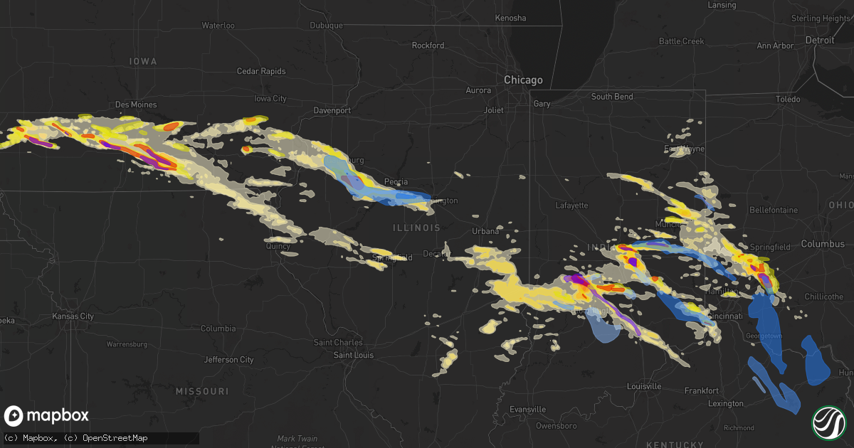
Hail Map in Illinois on June 18, 2021
Get this storm
June 18 map
$229
one time, instant access
Download today. No call, no setup
Keep the $229
Bought the map and want the full workflow? Apply the entire $229 to a subscription within 7 days. None of it is wasted.
Every map, not just this one
This buys you this map. Subscription and you get every map we run, in the markets you choose from a few cities to whole states to nationwide. Plus real-time alerts the moment a storm fires.
Contact data
Name, contact info, occupancy, even credit band for addresses in the footprint. You go from where it hit to who to call.
Become the source they trust
Unlimited branding weather history reports on demand. You already have the documented answer ready for the property owner, and you are the one who showed up with it.
Property data and RoofTrace estimates
Pull up any address you have got, its value and the exact code rules for that jurisdiction, straight from One Click Code. Then RoofTrace estimates the squares, pitch, and roof value, priced the way you price.
Storm reports in Illinois
Illinois
| Date | Description |
|---|---|
| 06/18/20216:56 AM CDT | A local report indicates 70 MPH wind near CAPITAL AIRPORT |
| 06/18/20216:53 AM CDT | 6 inch healthy tree limb snapped. |
| 06/18/20216:47 AM CDT | At 1147 PM CDT, a severe thunderstorm was located near London Mills, or 13 miles south of Galesburg, moving southeast at 30 mph. HAZARD...70 mph wind gusts and quarter size hail. SOURCE...Radar indicated. IMPACT...Hail damage to vehicles is expected. Expect considerable tree damage. Wind damage is also likely to mobile homes, roofs, and outbuildings. This severe thunderstorm will be near... London Mills and Maquon around 1155 PM CDT.Other locations in the path of this severe thunderstorm includeFairview, Farmington and Canton.This includes Interstate 74 between mile markers 50 and 84. |
| 06/18/20216:29 AM CDT | At 1129 PM CDT, a severe thunderstorm was located near Martinsville, or 10 miles west of Marshall, moving east at 35 mph. HAZARD...60 mph wind gusts and quarter size hail. SOURCE...Radar indicated. IMPACT...Hail damage to vehicles is expected. Expect wind damage to roofs, siding, and trees. This severe thunderstorm will be near... Clarksville around 1135 PM CDT. Marshall around 1145 PM CDT.This includes Interstate 70 between mile markers 130 and 154. |
| 06/18/20216:06 AM CDT | At 1106 PM CDT, a severe thunderstorm was located near Monmouth, moving southeast at 45 mph. HAZARD...60 mph wind gusts and quarter size hail. SOURCE...Radar indicated. IMPACT...Hail damage to vehicles is expected. Expect wind damage to roofs, siding, and trees. This severe thunderstorm will be near... Galesburg, Abingdon and Knoxville around 1125 PM CDT.Other locations in the path of this severe thunderstorm includeGilson, Maquon and Yates City.This includes Interstate 74 between mile markers 34 and 68. |
| 06/18/20215:48 AM CDT | Report from mping: trees uprooted or snapped; roof blown off. |
| 06/18/20215:42 AM CDT | At 1041 PM EDT, severe thunderstorms were located along a line extending from 9 miles southwest of Terre Haute to near Spencer, moving east at 40 mph. HAZARD...Ping pong ball size hail and 60 mph wind gusts. SOURCE...Radar indicated. IMPACT...People and animals outdoors will be injured. Expect hail damage to roofs, siding, windows, and vehicles. Expect wind damage to roofs, siding, and trees. Severe thunderstorms will be near... Spencer and McCormicks Creek State Park around 1050 PM EDT. Ellettsville and Stinesville around 1100 PM EDT.Other locations in the path of these severe thunderstorms includeCoalmont, Saline City, Bloomington, Clay City, Indiana University,Whitehall, Coal City, Unionville, Smithville, Patricksburg, MonroeReservoir, Lake Lemon, Woodville Hills and Freedom. |
| 06/18/20215:24 AM CDT | At 1024 PM CDT, a severe thunderstorm was located over Yates City, or 14 miles north of Canton, moving east at 35 mph. HAZARD...60 mph wind gusts and quarter size hail. SOURCE...Radar indicated. IMPACT...Hail damage to vehicles is expected. Expect wind damage to roofs, siding, and trees. This severe thunderstorm will be near... Elmwood around 1035 PM CDT. Trivoli and Brimfield around 1040 PM CDT.Other locations in the path of this severe thunderstorm include HannaCity.This includes Interstate 74 between mile markers 71 and 85. |
| 06/18/20215:17 AM CDT | At 1016 PM CDT, a severe thunderstorm was located over Wyman, or near Columbus Junction, moving east at 40 mph. HAZARD...Ping pong ball size hail. SOURCE...Radar indicated. IMPACT...People and animals outdoors will be injured. Expect damage to roofs, siding, windows, and vehicles. This severe thunderstorm will be near... Columbus Junction and Columbus City around 1020 PM CDT. Wapello, Morning Sun and Grandview around 1035 PM CDT.Other locations in the path of this severe thunderstorm includeAmber, Oakville, Toolesboro, New Boston, Mannon, Keithsburg, Joy,Millersburg and Seaton. |
| 06/18/20214:58 AM CDT | At 958 PM EDT, a severe thunderstorm was located near Spencer, or 22 miles northwest of Bloomington, moving east at 20 mph. HAZARD...Ping pong ball size hail. SOURCE...Radar indicated. IMPACT...People and animals outdoors will be injured. Expect damage to roofs, siding, windows, and vehicles. This severe thunderstorm will be near... Devore around 1010 PM EDT.This includes Interstate 70 between mile markers 1 and 27. |
| 06/18/20214:10 AM CDT | Multiple large tree limbs downed across town. Diameter of 12 inches or greater. Downed limbs caused structural damage to homes. |
| 06/18/20213:52 AM CDT | Tree through a roof in the 600 block of w green street. |
| 06/18/20213:45 AM CDT | Tree through a roof in the 600 block of w green st. |
| 06/18/20213:45 AM CDT | Power poles snapped and lines down. Power company on scene for repairs. |
| 06/18/20213:43 AM CDT | At 843 PM CDT, a severe thunderstorm was located over Springfield, moving east at 35 mph. HAZARD...60 mph wind gusts and quarter size hail. SOURCE...Radar indicated. IMPACT...Hail damage to vehicles is expected. Expect wind damage to roofs, siding, and trees. This severe thunderstorm will be near... Rochester and Riverton around 855 PM CDT.Other locations in the path of this severe thunderstorm includeMechanicsburg.This includes the following highways... Interstate 55 between mile markers 93 and 103. Interstate 72 between mile markers 99 and 121. |
| 06/18/20213:38 AM CDT | Large tree down in town. |
| 06/18/20213:22 AM CDT | At 822 PM CDT, a severe thunderstorm was located over Loami, or 13 miles southwest of Springfield, moving east at 30 mph. HAZARD...60 mph wind gusts and quarter size hail. SOURCE...Radar indicated. IMPACT...Hail damage to vehicles is expected. Expect wind damage to roofs, siding, and trees. This severe thunderstorm will be near... Auburn around 835 PM CDT. Chatham around 840 PM CDT.Other locations in the path of this severe thunderstorm includeSpringfield and Pawnee.This includes the following highways... Interstate 55 between mile markers 82 and 96. Interstate 72 between mile markers 81 and 102. |
| 06/18/20213:16 AM CDT | Tree reported down in road and on power lines. |
| 06/18/20212:15 AM CDT | Roof panels blown off the rp lumber company building on the southwest side of pontiac. Time estimated by radar. |
| 06/18/20211:11 AM CDT | Report from mping: 1-inch tree limbs broken; shingles blown off. |
| 06/18/20211:09 AM CDT | A local report indicates 58 MPH wind near MACKINAW |
| 06/18/20211:02 AM CDT | A local report indicates 60 MPH wind near 3 SSW MORTON |
| 06/18/202112:58 AM CDT | Corrects previous tstm wnd gst report from tremont. Measured at eoc. |
| 06/18/202112:58 AM CDT | Report of a large tree down on cars. |
| 06/18/202112:50 AM CDT | Trees down. |
| 06/18/202112:45 AM CDT | Report relayed by emergency manager. |
| 06/18/202112:11 AM CDT | Delayed report. Tree trunk snapped. Time estimated from radar. |
| 06/18/202112:10 AM CDT | Lots of trees down on north side of canton. Report relayed by broadcast media. Time estimated by radar. |
| 06/18/202112:10 AM CDT | Roof and siding damage. Time estimated by radar. |
| 06/18/202112:06 AM CDT | Power line and power poles broken off. |
| 06/18/202112:05 AM CDT | Delayed report. Large branches broken. Time estimated from radar. |
| 06/18/202112:00 AM CDT | Delayed report. Tree trunks snapped. Time estimated based on radar. |
| 06/18/202112:00 AM CDT | A local report indicates 90 MPH wind near 3 E SAINT AUGUSTINE |
| 06/18/202112:00 AM CDT | Trees down. Time estimated by radar. |
| 06/17/202111:59 PM CDT | Delayed report. Tree trunks snapped and power lines down. Time estimated from radar. |
| 06/17/202111:52 PM CDT | Report of farm equipment buildings damaged and powerlines blown into field. |
| 06/17/202111:50 PM CDT | Downed power lines and trees snapped on route 41. |
| 06/17/202111:50 PM CDT | Report of numerous trees snapped... Grain elevators severely damaged... And powerlines blown down. Estimated 80 mph winds based on damage. |
| 06/17/202111:50 PM CDT | This tornado mainly damaged trees... Crops... Power poles/lines. There was also significant damage to farm outbuildings and debris was thrown half a mile. The tornado e |
| 06/17/202111:48 PM CDT | Delayed report. Power poles broken. Time estimated from radar. |
| 06/17/202111:40 PM CDT | Delayed report. Tree and powerline damage. Power outages in town. Time estimated from radar. |
| 06/17/202111:40 PM CDT | Report of several trees snapped... A heavily damaged barn... And estimated wind speeds of 80-90 mph winds. |
| 06/17/202111:29 PM CDT | A local report indicates 58 MPH wind near GALESBURG AIRPORT |
| 06/17/202111:27 PM CDT | Time estimated from radar. Trees down on 110th street between 125th and 140th avenues. |
| 06/17/202111:24 PM CDT | Time estimated from radar. Trees down on 140th ave between 100th and 110th streets. |
| 06/17/202111:05 PM CDT | 2 large tree limbs blown down. |
| 06/17/202111:04 PM CDT | Large tree down. Picture posted to social media. |
| 06/17/202111:00 PM CDT | 2 large tree limbs blown down. |
| 06/17/20218:23 PM CDT | Delayed report. Sangamon county fair. Several tents blown over. Time estimated from radar. |
All States Impacted by Hail Map on June 18, 2021
Cities Impacted by Hail Map on June 18, 2021
- Vandalia, OH
- West Milton, OH
- Troy, OH
- Tipp City, OH
- Malvern, IA
- Silver City, IA
- Seymour, IN
- Albin, WY
- Pine Bluffs, WY
- Burns, WY
- Bowling Green, IN
- Coal City, IN
- Clay City, IN
- Terre Haute, IN
- Poland, IN
- Brazil, IN
- Freedom, IN
- Riley, IN
- Patricksburg, IN
- Spencer, IN
- Cory, IN
- Centerpoint, IN
- Greensburg, IN
- Saint Charles, IA
- Indianola, IA
- Prole, IA
- Saint Marys, IA
- Keota, IA
- West Chester, IA
- Washington, IA
- Wellman, IA
- Bussey, IA
- Cantril, IA
- Red Oak, IA
- Wyaconda, MO
- Macedonia, IA
- Centerville, IA
- Pulaski, IA
- Ackworth, IA
- Murray, IA
- Fontanelle, IA
- Griswold, IA
- Lewis, IA
- Peru, IA
- Corydon, IA
- Kahoka, MO
- Drakesville, IA
- Greenfield, IA
- Lacona, IA
- Woodburn, IA
- Truro, IA
- Ursa, IL
- Walnut, IA
- Avoca, IA
- Mystic, IA
- Cumberland, IA
- Stuart, IA
- Lucas, IA
- Alexandria, MO
- Anita, IA
- Mendon, IL
- Moulton, IA
- Winterset, IA
- Humeston, IA
- Downing, MO
- Wiota, IA
- Luray, MO
- Milton, IA
- Afton, IA
- Dexter, IA
- Albia, IA
- Villisca, IA
- Corning, IA
- Blakesburg, IA
- Moravia, IA
- Lorimor, IA
- Plano, IA
- Warsaw, IL
- Arbela, MO
- Atlantic, IA
- Creston, IA
- Orient, IA
- Melrose, IA
- Oakland, IA
- Memphis, MO
- Udell, IA
- Carson, IA
- Massena, IA
- West Point, IL
- Unionville, IA
- New Virginia, IA
- Elliott, IA
- Milo, IA
- Chariton, IA
- Osceola, IA
- Sutter, IL
- Millerton, IA
- Gorin, MO
- Macksburg, IA
- Adair, IA
- Russell, IA
- Derby, IA
- Bridgewater, IA
- Wayland, MO
- Casey, IA
- Canton, MO
- Treynor, IA
- Saint Patrick, MO
- Menlo, IA
- Bloomfield, IA
- Grant, IA
- Henderson, IA
- Promise City, IA
- Hancock, IA
- Columbus, IN
- Stinesville, IN
- Madison, IN
- Worthington, IN
- Tuscola, IL
- Reelsville, IN
- Nineveh, IN
- Lewis, IN
- Redmon, IL
- Stilesville, IN
- West Terre Haute, IN
- Philo, IL
- Commiskey, IN
- Morgantown, IN
- Nashville, IN
- Martinsville, IN
- Villa Grove, IL
- Deputy, IN
- Lexington, IN
- Campbellsburg, KY
- Bedford, KY
- Paris Crossing, IN
- Martinsville, IL
- West Union, IL
- Longview, IL
- Gosport, IN
- North Vernon, IN
- Arcola, IL
- Monrovia, IN
- Dennison, IL
- Austin, IN
- Trafalgar, IN
- Jasonville, IN
- Tolono, IL
- Hindsboro, IL
- Charleston, IL
- Newman, IL
- Ellettsville, IN
- Paragon, IN
- Camargo, IL
- Freetown, IN
- Kansas, IL
- Shelburn, IN
- Marshall, IL
- Westfield, IL
- Farmersburg, IN
- Edinburgh, IN
- Hymera, IN
- Franklin, IN
- Brocton, IL
- Ashmore, IL
- Greencastle, IN
- Fillmore, IN
- Hanover, IN
- Quincy, IN
- Milton, KY
- Pimento, IN
- Cloverdale, IN
- Oakland, IL
- Mooresville, IN
- Crothersville, IN
- Casey, IL
- Paris, IL
- Bargersville, IN
- Pesotum, IL
- Bloomington, IN
- Unionville, IN
- Coatesville, IN
- Clayton, IN
- Sadorus, IL
- Hume, IL
- Murdock, IL
- Valders, WI
- Neenah, WI
- Reedsville, WI
- Menasha, WI
- Brillion, WI
- Stockbridge, WI
- Chilton, WI
- Oshkosh, WI
- Kiel, WI
- Hilbert, WI
- Eaton, OH
- Dayton, OH
- Miamisburg, OH
- Springboro, OH
- Richmond, IN
- New Paris, OH
- New Madison, OH
- Fountain City, IN
- Hollansburg, OH
- Blackduck, MN
- Pennington, MN
- Bemidji, MN
- Knoxville, IA
- Pella, IA
- Alliance, NE
- Fairbury, NE
- Farina, IL
- Pacific Junction, IA
- Van Meter, IA
- Norwalk, IA
- Cumming, IA
- Keosauqua, IA
- Farmington, IA
- Bonaparte, IA
- Donnellson, IA
- Fort Madison, IA
- West Point, IA
- Lawrenceburg, IN
- Petersburg, KY
- Indianapolis, IN
- Marion, WI
- Hemingford, NE
- Harrison, NE
- Fairland, IN
- Fountaintown, IN
- Lovilia, IA
- Dunkirk, IN
- Redkey, IN
- Eaton, IN
- Albany, IN
- Portland, IN
- Ridgeville, IN
- Mccordsville, IN
- Greenfield, IN
- New Palestine, IN
- London Mills, IL
- Maquon, IL
- Saint Augustine, IL
- Abingdon, IL
- Gilson, IL
- Quincy, IL
- Payson, IL
- Liberty, IL
- Plainville, IL
- Pleasantville, IA
- Anderson, IN
- Oskaloosa, IA
- Monmouth, IL
- Morning Sun, IA
- Berwick, IL
- Canton, IL
- Burlington, IA
- Cuba, IL
- Oakville, IA
- Pekin, IL
- Hanna City, IL
- Green Valley, IL
- Oquawka, IL
- Little York, IL
- Danvers, IL
- Tremont, IL
- Minier, IL
- Delavan, IL
- Farmington, IL
- Shirley, IL
- Bloomington, IL
- Glasford, IL
- Yates City, IL
- Trivoli, IL
- Aledo, IL
- Hopedale, IL
- McLean, IL
- Stanford, IL
- Mediapolis, IA
- Knoxville, IL
- South Pekin, IL
- Seaton, IL
- Groveland, IL
- Cameron, IL
- Keithsburg, IL
- Avon, IL
- Kingston Mines, IL
- Norris, IL
- Ellisville, IL
- Galesburg, IL
- Elmwood, IL
- Gerlaw, IL
- Peoria, IL
- Biggsville, IL
- Kirkwood, IL
- Gladstone, IL
- Sperry, IA
- Morton, IL
- Alexis, IL
- Fairview, IL
- Mapleton, IL
- Saint David, IL
- Joy, IL
- Manito, IL
- Mackinaw, IL
- Muncie, IN
- Markleville, IN
- New Castle, IN
- Shirley, IN
- Wilkinson, IN
- Arthur, IL
- Lovington, IL
- Atwood, IL
- Pine River, WI
- Fremont, WI
- Oldenburg, IN
- Waynesville, OH
- Catlin, IL
- Oakwood, IL
- Lerna, IL
- Fairfield, IA
- Brighton, IA
- Middletown, IN
- Kennard, IN
- Pendleton, IN
- Connersville, IN
- Germantown, OH
- Ohiowa, NE
- Alexandria, NE
- Daykin, NE
- Tobias, NE
- Liberty, IN
- Shelbyville, IN
- Rushville, IN
- Manilla, IN
- Milroy, IN
- Waldron, IN
- Sumner, IL
- Cheyenne, WY
- Carpenter, WY
- Oblong, IL
- Ottumwa, IA
- Eddyville, IA
- Winchester, IN
- Farmland, IN
- New London, IA
- Danville, IA
- West Burlington, IA
- Salem, IA
- Middletown, IA
- Wever, IA
- Trenton, OH
- Hamilton, OH
- Cleves, OH
- Miamitown, OH
- Cincinnati, OH
- Wilmington, OH
- Williamsburg, IN
- Iuka, IL
- Winfield, IA
- Columbus City, IA
- Columbus Junction, IA
- Ainsworth, IA
- Crawfordsville, IA
- Wapello, IA
- Springport, IN
- Mooreland, IN
- Daleville, IN
- Springfield, IL
- Pleasant Plains, IL
- Kalona, IA
- Bridgeport, IL
- Minonk, IL
- Fairbury, IL
- Chenoa, IL
- Pontiac, IL
- Weldon, IA
- Leon, IA
- Hillsboro, OH
- Peebles, OH
- Latham, OH
- Milwaukee, WI
- Lockridge, IA
- Council Bluffs, IA
- Clintonville, WI
- Shiocton, WI
- Jansen, NE
- Diller, NE
- Fe Warren Afb, WY
- Union City, OH
- Union City, IN
- Eldon, IA
- Selma, IA
- Floris, IA
- Warren, IN
- Poneto, IN
- Liverpool, IL
- Lewistown, IL
- Arenzville, IL
- Rushville, IL
- Frederick, IL
- Mount Sterling, IL
- Beardstown, IL
- Virginia, IL
- Loami, IL
- New Berlin, IL
- Claremont, IL
- Arcanum, OH
- Fairborn, OH
- Clayton, OH
- Englewood, OH
- Brookville, OH
- Bellbrook, OH
- Spring Valley, OH
- Xenia, OH
- Branson, CO
- Mount Union, IA
- Marion, IN
- Saint Paul, IN
- Wabash, IN
- Bradford, OH
- Yorkshire, OH
- Centerville, IN
- Logansport, IN
- Brooklyn, IN
- Hartford City, IN
- Maria Stein, OH
- Jamestown, OH
- Carrollton, KY
- Boggstown, IN
- Beech Grove, IN
- Brookville, IN
- Ingalls, IN
- Greens Fork, IN
- Modoc, IN
- Ivesdale, IL
- Lynn, IN
- Alpha, OH
- Phillipsburg, OH
- Verona, OH
- Greenup, IL
- Rockford, OH
- Farmersville, OH
- Fishers, IN
- Peru, IN
- New Waverly, IN
- Zionsville, IN
- Sunman, IN
- Scottsburg, IN
- Laurel, IN
- Celina, OH
- West Newton, IN
- Eldorado, OH
- Bluffton, IN
- Greenwood, IN
- Hope, IN
- Fortville, IN
- Berne, IN
- Saint Henry, OH
- Sabina, OH
- Geneva, IN
- West York, IL
- Pittsboro, IN
- Morristown, IN
- Dupont, IN
- Walton, IN
- Palestine, OH
- New Weston, OH
- Bloomfield, IN
- Indianola, IL
- West Manchester, OH
- Brownsburg, IN
- Parker City, IN
- Whiteland, IN
- Broadlands, IL
- Wilberforce, OH
- Bryant, IN
- Upland, IN
- Knightstown, IN
- Economy, IN
- Hammond, IL
- Pitsburg, OH
- Plainfield, IN
- Ansonia, OH
- West Alexandria, OH
- Decatur, IL
- Staunton, IN
- Keystone, IN
- Chrisman, IL
- Ridge Farm, IL
- Batesville, IN
- Argenta, IL
- Bement, IL
- Norman, IN
- Annapolis, IL
- Oreana, IL
- Sidell, IL
- Pleasureville, KY
- New Vienna, OH
- Hutsonville, IL
- Allerton, IL
- Selma, IN
- Harmony, IN
- Straughn, IN
- Greenville, OH
- Cerro Gordo, IL
- Leesburg, OH
- La Fontaine, IN
- Coalmont, IN
- Camden, OH
- Cambridge City, IN
- Flat Rock, IN
- Losantville, IN
- Lewisburg, OH
- Carmel, IN
- Solsberry, IN
- Camby, IN
- Metcalf, IL
- Rossburg, OH
- La Place, IL
- Webster, IN
- Versailles, OH
- New Lebanon, OH
- Turners Station, KY
- Saratoga, IN
- Franklin, OH
- Hagerstown, IN
- Fairbanks, IN
- Laura, OH
- Covington, OH
- Port William, OH
- Needham, IN
- Brownstown, IN
- Coldwater, OH
- Knightsville, IN
- Fort Recovery, OH
- Golden, IL
- Loraine, IL
- Camp Point, IL
- Westfield, IN
- Delta, IA
- Rose Hill, IA
- Fremont, IA
- Hedrick, IA
- Lamar, CO
- Noblesville, IN
- Plattsmouth, NE
- Novelty, MO
- Chatham, IL
- Alexander, IL
- Guilford, IN
- Aurora, IN
- Milan, IN
- Jacksonville, IL
- Ashland, IL
- La Harpe, IL
- Blandinsville, IL
- Brownstown, IL
- Kinmundy, IL
- Harvey, IA
- Burlington, KY
- Lizton, IN
- Edgewood, IL
- Columbia, IA
- Cedar, IA
- Ollie, IA
- Verona, KY
- Warsaw, KY
- Glencoe, KY
- Dry Ridge, KY
- Auburn, IN
- Garrett, IN
- Laotto, IN
- Sullivan, IN
- Saint Elmo, IL
- Beecher City, IL
- Plainville, IN
- Washington, IN
- Mt Zion, IL
- What Cheer, IA
- Sigourney, IA
- Newton, IL
- Trilla, IL
- Mattoon, IL
- Vandalia, IL
- Ramsey, IL
- Texico, IL
- Kell, IL
- Xenia, IL
- Salem, IL
- Johnsonville, IL
- Wayland, IA
- Mount Pleasant, IA
- Strasburg, IL
- Shelbyville, IL
- La Grange, MO
- Fowler, IL
- Flat Rock, IL
- Melcher Dallas, IA
- Mason, OH
- South Lebanon, OH
- Morrow, OH
- Maineville, OH
- Blanchester, OH
- Kings Mills, OH
- Lebanon, OH
- Pleasant Plain, OH
- Glenwood, IA
- Livonia, MO
- Smithfield, IL
- Roseville, IL
- Yarmouth, IA
- Watseka, IL
- Sheldon, IL
- Tipton, IN
- Lawrenceville, IL
- Sheridan, IN
- Cicero, IN
- Arcadia, IN
- Greenfield, OH
- Larsen, WI
- Waupaca, WI
- Winneconne, WI
- Wild Rose, WI
- Walton, KY
- Crittenden, KY
- Morning View, KY
- Chapin, IL
- Concord, IL
- Coatsburg, IL
- Brownsville, IN
- Columbia City, IN
- Churubusco, IN
- Hebron, KY
- Florence, KY
- North Bend, OH
- Union, KY
- Willow Hill, IL
- Lapel, IN
- Hortonville, WI
- New London, WI
- Butler, IN
- Cantrall, IL
- Harper, IA
- Riverside, IA
- Camden, IL
- Timewell, IL
- Clayton, IL
- Huntsville, IL
- Chandlerville, IL
- Shobonier, IL
- West Chester, OH
- Hines, MN
- Olney, IL
- West Salem, IL
- Calhoun, IL
- Mount Carmel, IL
- Parkersburg, IL
- Leo, IN
- Huntertown, IN
- Fort Wayne, IN
- Lomax, IL
- Dallas City, IL
- Carthage, IL
- Dugger, IN
- Linton, IN
- Mechanicsburg, IL
- Rochester, IL
- Riverton, IL
- Tallula, IL
- Dawson, IL
- Forrest, IL
- Elizabethtown, IN
- Waterloo, WI
- Converse, IN
- Carlisle, IN
- North Prairie, WI
- Mukwonago, WI
- Waterloo, IN
- Garden Grove, IA
- East Peoria, IL
- Saint Joseph, IL
- Ogden, IL
- Kimberly, WI
- Appleton, WI
- Montgomery, IN
- Decatur, IN
- Ohio City, OH
- Roachdale, IN
- North Salem, IN
- West Liberty, IL
- Oxford, OH
- Fairmount, IL
- Mount Vernon, IL
- Woodlawn, IL
- Dix, IL
- Bluford, IL
- Clarksville, OH
- Milton, IN
- Bainbridge, OH
- Whitestown, IN
- Ladoga, IN
- New Ross, IN
- Crawfordsville, IN
- Chalmers, IN
- Reynolds, IN
- Roanoke, IN
- Brooksville, KY
- Foster, KY
- Odell, NE
- Monroe, IN
- Sandborn, IN
- Westphalia, IN
- Elnora, IN
- Tracy, IA
- Rosedale, IN
- Seymour, IA
- Willshire, OH
- Saint Peter, IL
- Independence, KY
- Patriot, IN
- Florence, IN
- Bennington, IN
- Osgood, IN
- Hooven, OH
- West Harrison, IN
- Moores Hill, IN
- Dillsboro, IN
- Rising Sun, IN
- Collins, WI
- Erlanger, KY
- Robinson, IL
- Heyworth, IL
- Fithian, IL
- Danville, IN
- Amo, IN
- Yale, IL
- Hamilton, IA
- Yoder, IN
- Fairfield, OH
- Bingham, IL
- Beatrice, NE
- Shickley, NE
- Bruning, NE
- Strang, NE
- Blue Springs, NE
- College Corner, OH
- Fisher, IL
- Mahomet, IL
- Dewey, IL
- Somerville, OH
- Middletown, OH
- Bainbridge, IN
- Charlottesville, IN
- Carthage, IN
- Oregonia, OH
- Lynchburg, OH
- Martinsville, OH
- New Trenton, IN
- Oaktown, IN
- Edwardsport, IN
- Bicknell, IN
- Argyle, IA
- Exline, IA
- Hayesville, IA
- Williamstown, MO
- East Galesburg, IL
- Monticello, MO
- Rutledge, MO
- Paloma, IL
- Montrose, IA
- Ewing, MO
- Leighton, IA
- Patterson, IA
- Bevington, IA
- New Boston, IL
- Armington, IL
- Douds, IA
- Emerson, IA
- Earlham, IA
- Olds, IA
- Minden, IA
- Maywood, MO
- North Henderson, IL
- Mount Sterling, IA
- Bellevue, NE
- Revere, MO
- South English, IA
- Cincinnati, IA
- Saint Francisville, IL
- Allerton, IA
- New Bremen, OH
- Minster, OH
- Sidney, IL
- Cedar Grove, IN
- Okeana, OH
- Sparta, KY
- Normal, IL
- Carlock, IL
- Grover, CO
- Fayetteville, OH
- Aberdeen, OH
- Bethel, OH
- Winchester, OH
- Wallingford, KY
- Hamersville, OH
- Sardinia, OH
- Owensville, OH
- Ripley, OH
- Mayslick, KY
- Augusta, KY
- Dover, KY
- Manchester, OH
- Vanceburg, KY
- Russellville, OH
- Flemingsburg, KY
- Goshen, OH
- Batavia, OH
- Georgetown, OH
- West Union, OH
- Mount Orab, OH
- Williamsburg, OH
- Midland, OH
- Maysville, KY
- Tollesboro, KY
- Emerson, KY
- Blue Creek, OH
- Stout, OH
- Greenup, KY
- Olive Hill, KY
- South Shore, KY
- Garrison, KY
- Argillite, KY
- West Portsmouth, OH
- South Portsmouth, KY
- Friendship, OH
- Quincy, KY
- Otway, OH
- Grayson, KY
- Owingsville, KY
- Moorefield, KY
- Morehead, KY
- Olympia, KY
- West Liberty, KY
- Ezel, KY
- Ewing, KY
- Germantown, KY
- Frenchburg, KY
- Hillsboro, KY
- Mount Olivet, KY
- Salt Lick, KY
- Clearfield, KY
- Wellington, KY
- Carlisle, KY
- Sharpsburg, KY
- Mineola, IA
- Yellow Springs, OH
- Cedarville, OH
- Spiceland, IN
- Lewisville, IN
- Versailles, IN
- Napoleon, IN
- Springville, IN
- Avoca, IN
- Medora, IN
- Oolitic, IN
- Bedford, IN
- Heltonville, IN
- Squaw Lake, MN
- Putnamville, IN
- Homer, IN


