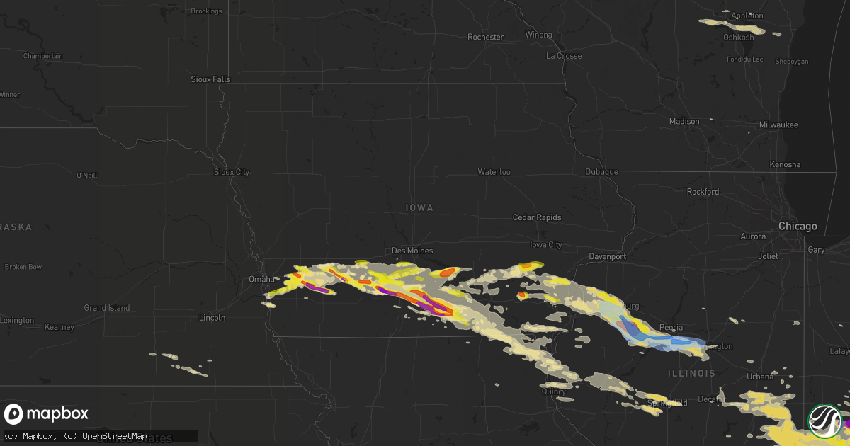
Hail Map in Iowa on June 18, 2021
Get this storm
June 18 map
$229
one time, instant access
Download today. No call, no setup
Keep the $229
Bought the map and want the full workflow? Apply the entire $229 to a subscription within 7 days. None of it is wasted.
Every map, not just this one
This buys you this map. Subscription and you get every map we run, in the markets you choose from a few cities to whole states to nationwide. Plus real-time alerts the moment a storm fires.
Contact data
Name, contact info, occupancy, even credit band for addresses in the footprint. You go from where it hit to who to call.
Become the source they trust
Unlimited branding weather history reports on demand. You already have the documented answer ready for the property owner, and you are the one who showed up with it.
Property data and RoofTrace estimates
Pull up any address you have got, its value and the exact code rules for that jurisdiction, straight from One Click Code. Then RoofTrace estimates the squares, pitch, and roof value, priced the way you price.
Storm reports in Iowa
Iowa
| Date | Description |
|---|---|
| 06/18/202111:37 AM CDT | Power pole snapped at base and another three-fourths of the way up. Time estimated from radar. |
| 06/18/202111:13 AM CDT | One and a half inch hail one and a half mile south of red rock dam. Via social media. |
| 06/18/20216:59 AM CDT | At 1159 PM CDT, a severe thunderstorm was located near Green Valley Lake, or 7 miles north of Creston, moving southeast at 35 mph. HAZARD...60 mph wind gusts and half dollar size hail. SOURCE...Radar indicated. IMPACT...Hail damage to vehicles is expected. Expect wind damage to roofs, siding, and trees. This severe thunderstorm will be near... Creston around 1210 AM CDT. |
| 06/18/20216:56 AM CDT | At 1155 PM CDT, a severe thunderstorm was located over Macedonia, or 27 miles southwest of Atlantic, moving east at 40 mph. HAZARD...60 mph wind gusts and half dollar size hail. SOURCE...Radar indicated. IMPACT...Hail damage to vehicles is expected. Expect wind damage to roofs, siding, and trees. This severe thunderstorm will be near... Oakland around 1205 AM CDT. |
| 06/18/20216:55 AM CDT | At 1155 PM CDT, a severe thunderstorm was located 8 miles north of Corydon, moving southeast at 30 mph. HAZARD...Ping pong ball size hail and 60 mph wind gusts. SOURCE...Radar indicated. IMPACT...People and animals outdoors will be injured. Expect hail damage to roofs, siding, windows, and vehicles. Expect wind damage to roofs, siding, and trees. This severe thunderstorm will be near... Rathbun Lake around 1210 AM CDT.Other locations in the path of this severe thunderstorm includeCenterville. |
| 06/18/20216:54 AM CDT | At 1154 PM CDT, a severe thunderstorm was located 8 miles south of Winterset, moving east at 30 mph. HAZARD...60 mph wind gusts and quarter size hail. SOURCE...Radar indicated. IMPACT...Hail damage to vehicles is expected. Expect wind damage to roofs, siding, and trees. Locations impacted include... Osceola.This includes Interstate 35 between mile markers 35 and 51. |
| 06/18/20216:47 AM CDT | At 1147 PM CDT, a severe thunderstorm was located over Washington, moving east at 35 mph. HAZARD...Quarter size hail. SOURCE...Radar indicated. IMPACT...Damage to vehicles is expected. This severe thunderstorm will be near... Ainsworth around 1155 PM CDT. Crawfordsville around 1200 AM CDT. Cotter and Wyman around 1205 AM CDT.Other locations in the path of this severe thunderstorm includeColumbus Junction, Columbus City and Letts. |
| 06/18/20216:43 AM CDT | At 1142 PM CDT, a severe thunderstorm was located west of Griswold, or 16 miles southwest of Atlantic, moving east at 30 mph. HAZARD...Golf ball size hail and 60 mph wind gusts. SOURCE...Radar indicated. IMPACT...People and animals outdoors will be injured. Expect hail damage to roofs, siding, windows, and vehicles. Expect wind damage to roofs, siding, and trees. This severe thunderstorm will remain over mainly rural areas of northern Montgomery and southeastern Pottawattamie Counties, including the following locations... Grant and Farm Creek Public Wildlife Area.Other locations in the path of this severe thunderstorm include Elliott. |
| 06/18/20216:37 AM CDT | At 1137 PM CDT, a severe thunderstorm was located 10 miles west of Greenfield, moving southeast at 25 mph. HAZARD...Two inch hail and 60 mph wind gusts. SOURCE...Radar indicated. IMPACT...People and animals outdoors will be injured. Expect hail damage to roofs, siding, windows, and vehicles. Expect wind damage to roofs, siding, and trees. Locations impacted include... Greenfield and Green Valley Lake. |
| 06/18/20216:36 AM CDT | At 1135 PM CDT, a severe thunderstorm was located over Biggsville, or near Oquawka, moving east at 30 mph. HAZARD...Golf ball size hail and 60 mph wind gusts. SOURCE...Radar indicated. IMPACT...People and animals outdoors will be injured. Expect hail damage to roofs, siding, windows, and vehicles. Expect wind damage to roofs, siding, and trees. This severe thunderstorm will be near... Kirkwood around 1150 PM CDT.Other locations in the path of this severe thunderstorm includeMonmouth and Roseville. |
| 06/18/20216:32 AM CDT | At 1132 PM CDT, a severe thunderstorm was located near Griswold, or 11 miles southwest of Atlantic, moving east at 40 mph. HAZARD...Ping pong ball size hail and 60 mph wind gusts. SOURCE...Radar indicated. IMPACT...People and animals outdoors will be injured. Expect hail damage to roofs, siding, windows, and vehicles. Expect wind damage to roofs, siding, and trees. This severe thunderstorm will be near... Griswold around 1140 PM CDT. |
| 06/18/20216:29 AM CDT | At 1129 PM CDT, a severe thunderstorm was located near Mount Union, or 7 miles northeast of Mount Pleasant, moving east at 30 mph. HAZARD...Quarter size hail. SOURCE...Radar indicated. IMPACT...Damage to vehicles is expected. This severe thunderstorm will be near... Mount Union around 1135 PM CDT.Other locations in the path of this severe thunderstorm includeMorning Sun and Mediapolis. |
| 06/18/20216:25 AM CDT | At 1125 PM CDT, a severe thunderstorm was located 11 miles east of Osceola, moving southeast at 30 mph. HAZARD...Ping pong ball size hail and 60 mph wind gusts. SOURCE...Radar indicated. IMPACT...People and animals outdoors will be injured. Expect hail damage to roofs, siding, windows, and vehicles. Expect wind damage to roofs, siding, and trees. Locations impacted include... Corydon.This includes Interstate 35 between mile markers 30 and 31. |
| 06/18/20216:21 AM CDT | At 1121 PM CDT, a severe thunderstorm was located near Fairfield, moving east at 30 mph. HAZARD...Golf ball size hail and 60 mph wind gusts. SOURCE...Radar indicated. IMPACT...People and animals outdoors will be injured. Expect hail damage to roofs, siding, windows, and vehicles. Expect wind damage to roofs, siding, and trees. This severe thunderstorm will be near... Lockridge around 1135 PM CDT.Other locations in the path of this severe thunderstorm include Rome,Westwood and Mount Pleasant. |
| 06/18/20216:19 AM CDT | At 1119 PM CDT, a severe thunderstorm was located near Oskaloosa, moving east at 35 mph. HAZARD...60 mph wind gusts and quarter size hail. SOURCE...Radar indicated. IMPACT...Hail damage to vehicles is expected. Expect wind damage to roofs, siding, and trees. This severe thunderstorm will remain over mainly rural areas of southeastern Mahaska County, including the following locations... University Park, Beacon, Keomah Village, Rose Hill, Lake Keomah State Park, Fremont and Oskaloosa Municipal Airport. |
| 06/18/20216:14 AM CDT | At 1114 PM CDT, a severe thunderstorm was located 10 miles east of Greenfield, moving east at 30 mph. HAZARD...60 mph wind gusts and quarter size hail. SOURCE...Radar indicated. IMPACT...Hail damage to vehicles is expected. Expect wind damage to roofs, siding, and trees. Locations impacted include... Winterset. |
| 06/18/20216:10 AM CDT | At 1110 PM CDT, a severe thunderstorm was located 9 miles northwest of Rathbun Lake, or 10 miles southeast of Chariton, moving southeast at 30 mph. HAZARD...Golf ball size hail and 60 mph wind gusts. SOURCE...Radar indicated. IMPACT...People and animals outdoors will be injured. Expect hail damage to roofs, siding, windows, and vehicles. Expect wind damage to roofs, siding, and trees. This severe thunderstorm will be near... Rathbun Lake around 1115 PM CDT.Other locations in the path of this severe thunderstorm includeCenterville and Lake Sundown. |
| 06/18/20216:07 AM CDT | At 1105 PM CDT, a severe thunderstorm was located 6 miles northeast of Oakland, or 15 miles west of Atlantic, moving east at 25 mph. HAZARD...60 mph wind gusts and quarter size hail. SOURCE...Radar indicated. IMPACT...Hail damage to vehicles is expected. Expect wind damage to roofs, siding, and trees. This severe thunderstorm will remain over mainly rural areas of eastern Pottawattamie County, including the following locations... Botna Bend Park, Old Town Park, Hancock and Farm Creek Public Wildlife Area. |
| 06/18/20216:05 AM CDT | At 1104 PM CDT, a severe thunderstorm was located near Knoxville Raceway, or over Knoxville, moving east at 40 mph. HAZARD...60 mph wind gusts and quarter size hail. SOURCE...Radar indicated. IMPACT...Hail damage to vehicles is expected. Expect wind damage to roofs, siding, and trees. This severe thunderstorm will be near... Lake Red Rock around 1110 PM CDT.Other locations in the path of this severe thunderstorm includePella. |
| 06/18/20216:03 AM CDT | At 1103 PM CDT, a severe thunderstorm was located over Mediapolis, or 9 miles northwest of Oquawka, moving east at 35 mph. HAZARD...60 mph wind gusts and quarter size hail. SOURCE...Radar indicated. IMPACT...Hail damage to vehicles is expected. Expect wind damage to roofs, siding, and trees. This severe thunderstorm will be near... Oquawka around 1120 PM CDT. |
| 06/18/20216:02 AM CDT | At 1102 PM CDT, a severe thunderstorm was located over Rozetta, or near Oquawka, moving east at 25 mph. HAZARD...60 mph wind gusts and quarter size hail. SOURCE...Radar indicated. IMPACT...Hail damage to vehicles is expected. Expect wind damage to roofs, siding, and trees. This severe thunderstorm will be near... Kirkwood around 1115 PM CDT.Other locations in the path of this severe thunderstorm includeMonmouth. |
| 06/18/20215:54 AM CDT | At 1054 PM CDT, a severe thunderstorm was located near Atlantic, moving east at 30 mph. HAZARD...Ping pong ball size hail and 60 mph wind gusts. SOURCE...Radar indicated. IMPACT...People and animals outdoors will be injured. Expect hail damage to roofs, siding, windows, and vehicles. Expect wind damage to roofs, siding, and trees. This severe thunderstorm will remain over mainly rural areas of southeastern Cass and western Adair Counties, including the following locations... Wiota, Bridgewater, Cumberland, Lake Anita State Park, Massena and Fontanelle. |
| 06/18/20215:45 AM CDT | At 1044 PM CDT, a severe thunderstorm was located over Seaton, or 7 miles southwest of Aledo, moving east at 25 mph. HAZARD...Golf ball size hail. SOURCE...Radar indicated. IMPACT...People and animals outdoors will be injured. Expect damage to roofs, siding, windows, and vehicles. This severe thunderstorm will be near... Aledo and Little York around 1100 PM CDT.Other locations in the path of this severe thunderstorm includeBurgess, Lake Warren and North Henderson. |
| 06/18/20215:45 AM CDT | At 1045 PM CDT, a severe thunderstorm was located 8 miles northwest of Albia, moving east at 30 mph. HAZARD...60 mph wind gusts and quarter size hail. SOURCE...Radar indicated. IMPACT...Hail damage to vehicles is expected. Expect wind damage to roofs, siding, and trees. This severe thunderstorm will be near... Albia around 1100 PM CDT. |
| 06/18/20215:43 AM CDT | At 1043 PM CDT, a severe thunderstorm was located 14 miles south of Winterset, moving east at 30 mph. HAZARD...60 mph wind gusts and half dollar size hail. SOURCE...Radar indicated. IMPACT...Hail damage to vehicles is expected. Expect wind damage to roofs, siding, and trees. Locations impacted include... Osceola and Lakeside Casino.This includes Interstate 35 between mile markers 30 and 48. |
| 06/18/20215:39 AM CDT | At 1038 PM CDT, a severe thunderstorm was located 9 miles northwest of Chariton, moving east at 30 mph. HAZARD...Golf ball size hail and 60 mph wind gusts. SOURCE...Radar indicated. IMPACT...People and animals outdoors will be injured. Expect hail damage to roofs, siding, windows, and vehicles. Expect wind damage to roofs, siding, and trees. This severe thunderstorm will be near... Chariton around 1055 PM CDT. |
| 06/18/20215:06 AM CDT | At 1005 PM CDT, a severe thunderstorm was located 8 miles north of Green Valley Lake, or 8 miles southeast of Greenfield, moving east at 35 mph. HAZARD...60 mph wind gusts and quarter size hail. SOURCE...Radar indicated. IMPACT...Hail damage to vehicles is expected. Expect wind damage to roofs, siding, and trees. This severe thunderstorm will remain over mainly rural areas of southwestern Madison, northeastern Union, northwestern Clarke and southeastern Adair Counties, including the following locations... Orient, Lorimor, Macksburg and East Peru. |
| 06/18/20214:56 AM CDT | At 955 PM CDT, a severe thunderstorm was located 8 miles north of Osceola, moving east at 35 mph. HAZARD...60 mph wind gusts and quarter size hail. SOURCE...Radar indicated. IMPACT...Hail damage to vehicles is expected. Expect wind damage to roofs, siding, and trees. Locations impacted include... Chariton.This includes Interstate 35 between mile markers 36 and 48. |
| 06/18/20211:47 AM CDT | Tree down on a carport. |
| 06/18/20211:37 AM CDT | Tree branch down across road. |
| 06/18/20211:16 AM CDT | Corn flattened in a large area around milton. |
| 06/18/20211:12 AM CDT | Delayed report. From home weather station. |
| 06/18/202112:56 AM CDT | Small tree limbs broken and shingles blown off. |
| 06/18/202112:45 AM CDT | Large tree blocking the road at the intersection of 46th st. And l ave. Time estimated based on radar. |
| 06/18/202112:17 AM CDT | Report and picture via social media. |
| 06/18/202112:07 AM CDT | Tree took down a power line at the intersection of harrison and main streets. |
| 06/18/202112:00 AM CDT | Emergency manager reports hail ranging from the sized of ping pongs to golf balls. A few larger than golf ball sized stones were also noted. |
| 06/17/202111:56 PM CDT | Blakesburg fire department reporting heavy tree damage and some damage to homes as in soffits tore off. |
| 06/17/202111:46 PM CDT | Delayed report. Time estimated from radar. |
| 06/17/202111:37 PM CDT | Corrects previous tstm wnd dmg report from 2 e humeston. Power pole snapped at base and another three-fourths of the way up. Time estimated from radar. |
| 06/17/202111:35 PM CDT | Social media post of hail ranging from quarter to tennis ball sized. |
| 06/17/202111:35 PM CDT | Near red rock campgrounds. |
| 06/17/202111:33 PM CDT | Irregular shaped hail; some up to 4 inches in diameter. Delayed report. |
| 06/17/202111:32 PM CDT | Quarter to half dollar sized hail at kjan studios. |
| 06/17/202111:31 PM CDT | Report from mping: 1-inch tree limbs broken; shingles blown off. |
| 06/17/202111:30 PM CDT | Report via social media. |
| 06/17/202111:30 PM CDT | Report from mping: golf ball |
| 06/17/202111:27 PM CDT | Downtown oakland... Ia. |
| 06/17/202111:20 PM CDT | A local report indicates 1.25 inch wind near OAKLAND |
| 06/17/202111:15 PM CDT | Howell station camp ground just south of red rock. |
| 06/17/202111:13 PM CDT | Corrects previous hail report from 4 wnw harvey. One and a half inch hail one and a half mile south of red rock dam. Via social media. |
| 06/17/202111:12 PM CDT | Also reported wind gusts up to 65 mph. |
| 06/17/202111:10 PM CDT | Report via social media. |
| 06/17/202111:10 PM CDT | A local report indicates 1.00 inch wind near 2 NNE OSCEOLA |
| 06/17/202111:09 PM CDT | Via social media/broadcast media. Time estimated from radar. |
| 06/17/202111:08 PM CDT | A local report indicates 1.00 inch wind near 1 WNW INDIANOLA |
| 06/17/202111:08 PM CDT | Delayed report. Time estimated from radar. |
| 06/17/202111:07 PM CDT | Mostly quarter to golf ball sized hail with sporadic tennis ball sized hail. Via social media/broadcast media. Time estimated from radar. |
| 06/17/202111:06 PM CDT | Public report via media on social media. |
| 06/17/202111:05 PM CDT | Large tree knocked down. Report via social media. |
| 06/17/202110:55 PM CDT | Powerlines down. |
| 06/17/202110:55 PM CDT | Lucas county sheriffs office reported quarter sized hail at the office. |
| 06/17/202110:55 PM CDT | Lucas county sheriffs office reported quarter sized hail at the office. |
| 06/17/202110:55 PM CDT | A local report indicates 1.00 inch wind near CHARITON |
| 06/17/202110:39 PM CDT | Via pictures on social media. Time estimated from radar. |
| 06/17/202110:33 PM CDT | A local report indicates 1.25 inch wind near 6 W LACONA |
| 06/17/202110:20 PM CDT | Delayed report. 72 hour rainfall total 6/18 to 6/21 of 4.24 inches as well. |
| 06/17/202110:20 PM CDT | Delayed report of half dollar sized hail relayed via social media. |
| 06/17/202110:09 PM CDT | Delayed report from last night. |
| 06/17/202110:05 PM CDT | Trained spotter reported lots of golf ball sized hail. |
All States Impacted by Hail Map on June 18, 2021
Cities Impacted by Hail Map on June 18, 2021
- Vandalia, OH
- West Milton, OH
- Troy, OH
- Tipp City, OH
- Malvern, IA
- Silver City, IA
- Seymour, IN
- Albin, WY
- Pine Bluffs, WY
- Burns, WY
- Bowling Green, IN
- Coal City, IN
- Clay City, IN
- Terre Haute, IN
- Poland, IN
- Brazil, IN
- Freedom, IN
- Riley, IN
- Patricksburg, IN
- Spencer, IN
- Cory, IN
- Centerpoint, IN
- Greensburg, IN
- Saint Charles, IA
- Indianola, IA
- Prole, IA
- Saint Marys, IA
- Keota, IA
- West Chester, IA
- Washington, IA
- Wellman, IA
- Bussey, IA
- Cantril, IA
- Red Oak, IA
- Wyaconda, MO
- Macedonia, IA
- Centerville, IA
- Pulaski, IA
- Ackworth, IA
- Murray, IA
- Fontanelle, IA
- Griswold, IA
- Lewis, IA
- Peru, IA
- Corydon, IA
- Kahoka, MO
- Drakesville, IA
- Greenfield, IA
- Lacona, IA
- Woodburn, IA
- Truro, IA
- Ursa, IL
- Walnut, IA
- Avoca, IA
- Mystic, IA
- Cumberland, IA
- Stuart, IA
- Lucas, IA
- Alexandria, MO
- Anita, IA
- Mendon, IL
- Moulton, IA
- Winterset, IA
- Humeston, IA
- Downing, MO
- Wiota, IA
- Luray, MO
- Milton, IA
- Afton, IA
- Dexter, IA
- Albia, IA
- Villisca, IA
- Corning, IA
- Blakesburg, IA
- Moravia, IA
- Lorimor, IA
- Plano, IA
- Warsaw, IL
- Arbela, MO
- Atlantic, IA
- Creston, IA
- Orient, IA
- Melrose, IA
- Oakland, IA
- Memphis, MO
- Udell, IA
- Carson, IA
- Massena, IA
- West Point, IL
- Unionville, IA
- New Virginia, IA
- Elliott, IA
- Milo, IA
- Chariton, IA
- Osceola, IA
- Sutter, IL
- Millerton, IA
- Gorin, MO
- Macksburg, IA
- Adair, IA
- Russell, IA
- Derby, IA
- Bridgewater, IA
- Wayland, MO
- Casey, IA
- Canton, MO
- Treynor, IA
- Saint Patrick, MO
- Menlo, IA
- Bloomfield, IA
- Grant, IA
- Henderson, IA
- Promise City, IA
- Hancock, IA
- Columbus, IN
- Stinesville, IN
- Madison, IN
- Worthington, IN
- Tuscola, IL
- Reelsville, IN
- Nineveh, IN
- Lewis, IN
- Redmon, IL
- Stilesville, IN
- West Terre Haute, IN
- Philo, IL
- Commiskey, IN
- Morgantown, IN
- Nashville, IN
- Martinsville, IN
- Villa Grove, IL
- Deputy, IN
- Lexington, IN
- Campbellsburg, KY
- Bedford, KY
- Paris Crossing, IN
- Martinsville, IL
- West Union, IL
- Longview, IL
- Gosport, IN
- North Vernon, IN
- Arcola, IL
- Monrovia, IN
- Dennison, IL
- Austin, IN
- Trafalgar, IN
- Jasonville, IN
- Tolono, IL
- Hindsboro, IL
- Charleston, IL
- Newman, IL
- Ellettsville, IN
- Paragon, IN
- Camargo, IL
- Freetown, IN
- Kansas, IL
- Shelburn, IN
- Marshall, IL
- Westfield, IL
- Farmersburg, IN
- Edinburgh, IN
- Hymera, IN
- Franklin, IN
- Brocton, IL
- Ashmore, IL
- Greencastle, IN
- Fillmore, IN
- Hanover, IN
- Quincy, IN
- Milton, KY
- Pimento, IN
- Cloverdale, IN
- Oakland, IL
- Mooresville, IN
- Crothersville, IN
- Casey, IL
- Paris, IL
- Bargersville, IN
- Pesotum, IL
- Bloomington, IN
- Unionville, IN
- Coatesville, IN
- Clayton, IN
- Sadorus, IL
- Hume, IL
- Murdock, IL
- Valders, WI
- Neenah, WI
- Reedsville, WI
- Menasha, WI
- Brillion, WI
- Stockbridge, WI
- Chilton, WI
- Oshkosh, WI
- Kiel, WI
- Hilbert, WI
- Eaton, OH
- Dayton, OH
- Miamisburg, OH
- Springboro, OH
- Richmond, IN
- New Paris, OH
- New Madison, OH
- Fountain City, IN
- Hollansburg, OH
- Blackduck, MN
- Pennington, MN
- Bemidji, MN
- Knoxville, IA
- Pella, IA
- Alliance, NE
- Fairbury, NE
- Farina, IL
- Pacific Junction, IA
- Van Meter, IA
- Norwalk, IA
- Cumming, IA
- Keosauqua, IA
- Farmington, IA
- Bonaparte, IA
- Donnellson, IA
- Fort Madison, IA
- West Point, IA
- Lawrenceburg, IN
- Petersburg, KY
- Indianapolis, IN
- Marion, WI
- Hemingford, NE
- Harrison, NE
- Fairland, IN
- Fountaintown, IN
- Lovilia, IA
- Dunkirk, IN
- Redkey, IN
- Eaton, IN
- Albany, IN
- Portland, IN
- Ridgeville, IN
- Mccordsville, IN
- Greenfield, IN
- New Palestine, IN
- London Mills, IL
- Maquon, IL
- Saint Augustine, IL
- Abingdon, IL
- Gilson, IL
- Quincy, IL
- Payson, IL
- Liberty, IL
- Plainville, IL
- Pleasantville, IA
- Anderson, IN
- Oskaloosa, IA
- Monmouth, IL
- Morning Sun, IA
- Berwick, IL
- Canton, IL
- Burlington, IA
- Cuba, IL
- Oakville, IA
- Pekin, IL
- Hanna City, IL
- Green Valley, IL
- Oquawka, IL
- Little York, IL
- Danvers, IL
- Tremont, IL
- Minier, IL
- Delavan, IL
- Farmington, IL
- Shirley, IL
- Bloomington, IL
- Glasford, IL
- Yates City, IL
- Trivoli, IL
- Aledo, IL
- Hopedale, IL
- McLean, IL
- Stanford, IL
- Mediapolis, IA
- Knoxville, IL
- South Pekin, IL
- Seaton, IL
- Groveland, IL
- Cameron, IL
- Keithsburg, IL
- Avon, IL
- Kingston Mines, IL
- Norris, IL
- Ellisville, IL
- Galesburg, IL
- Elmwood, IL
- Gerlaw, IL
- Peoria, IL
- Biggsville, IL
- Kirkwood, IL
- Gladstone, IL
- Sperry, IA
- Morton, IL
- Alexis, IL
- Fairview, IL
- Mapleton, IL
- Saint David, IL
- Joy, IL
- Manito, IL
- Mackinaw, IL
- Muncie, IN
- Markleville, IN
- New Castle, IN
- Shirley, IN
- Wilkinson, IN
- Arthur, IL
- Lovington, IL
- Atwood, IL
- Pine River, WI
- Fremont, WI
- Oldenburg, IN
- Waynesville, OH
- Catlin, IL
- Oakwood, IL
- Lerna, IL
- Fairfield, IA
- Brighton, IA
- Middletown, IN
- Kennard, IN
- Pendleton, IN
- Connersville, IN
- Germantown, OH
- Ohiowa, NE
- Alexandria, NE
- Daykin, NE
- Tobias, NE
- Liberty, IN
- Shelbyville, IN
- Rushville, IN
- Manilla, IN
- Milroy, IN
- Waldron, IN
- Sumner, IL
- Cheyenne, WY
- Carpenter, WY
- Oblong, IL
- Ottumwa, IA
- Eddyville, IA
- Winchester, IN
- Farmland, IN
- New London, IA
- Danville, IA
- West Burlington, IA
- Salem, IA
- Middletown, IA
- Wever, IA
- Trenton, OH
- Hamilton, OH
- Cleves, OH
- Miamitown, OH
- Cincinnati, OH
- Wilmington, OH
- Williamsburg, IN
- Iuka, IL
- Winfield, IA
- Columbus City, IA
- Columbus Junction, IA
- Ainsworth, IA
- Crawfordsville, IA
- Wapello, IA
- Springport, IN
- Mooreland, IN
- Daleville, IN
- Springfield, IL
- Pleasant Plains, IL
- Kalona, IA
- Bridgeport, IL
- Minonk, IL
- Fairbury, IL
- Chenoa, IL
- Pontiac, IL
- Weldon, IA
- Leon, IA
- Hillsboro, OH
- Peebles, OH
- Latham, OH
- Milwaukee, WI
- Lockridge, IA
- Council Bluffs, IA
- Clintonville, WI
- Shiocton, WI
- Jansen, NE
- Diller, NE
- Fe Warren Afb, WY
- Union City, OH
- Union City, IN
- Eldon, IA
- Selma, IA
- Floris, IA
- Warren, IN
- Poneto, IN
- Liverpool, IL
- Lewistown, IL
- Arenzville, IL
- Rushville, IL
- Frederick, IL
- Mount Sterling, IL
- Beardstown, IL
- Virginia, IL
- Loami, IL
- New Berlin, IL
- Claremont, IL
- Arcanum, OH
- Fairborn, OH
- Clayton, OH
- Englewood, OH
- Brookville, OH
- Bellbrook, OH
- Spring Valley, OH
- Xenia, OH
- Branson, CO
- Mount Union, IA
- Marion, IN
- Saint Paul, IN
- Wabash, IN
- Bradford, OH
- Yorkshire, OH
- Centerville, IN
- Logansport, IN
- Brooklyn, IN
- Hartford City, IN
- Maria Stein, OH
- Jamestown, OH
- Carrollton, KY
- Boggstown, IN
- Beech Grove, IN
- Brookville, IN
- Ingalls, IN
- Greens Fork, IN
- Modoc, IN
- Ivesdale, IL
- Lynn, IN
- Alpha, OH
- Phillipsburg, OH
- Verona, OH
- Greenup, IL
- Rockford, OH
- Farmersville, OH
- Fishers, IN
- Peru, IN
- New Waverly, IN
- Zionsville, IN
- Sunman, IN
- Scottsburg, IN
- Laurel, IN
- Celina, OH
- West Newton, IN
- Eldorado, OH
- Bluffton, IN
- Greenwood, IN
- Hope, IN
- Fortville, IN
- Berne, IN
- Saint Henry, OH
- Sabina, OH
- Geneva, IN
- West York, IL
- Pittsboro, IN
- Morristown, IN
- Dupont, IN
- Walton, IN
- Palestine, OH
- New Weston, OH
- Bloomfield, IN
- Indianola, IL
- West Manchester, OH
- Brownsburg, IN
- Parker City, IN
- Whiteland, IN
- Broadlands, IL
- Wilberforce, OH
- Bryant, IN
- Upland, IN
- Knightstown, IN
- Economy, IN
- Hammond, IL
- Pitsburg, OH
- Plainfield, IN
- Ansonia, OH
- West Alexandria, OH
- Decatur, IL
- Staunton, IN
- Keystone, IN
- Chrisman, IL
- Ridge Farm, IL
- Batesville, IN
- Argenta, IL
- Bement, IL
- Norman, IN
- Annapolis, IL
- Oreana, IL
- Sidell, IL
- Pleasureville, KY
- New Vienna, OH
- Hutsonville, IL
- Allerton, IL
- Selma, IN
- Harmony, IN
- Straughn, IN
- Greenville, OH
- Cerro Gordo, IL
- Leesburg, OH
- La Fontaine, IN
- Coalmont, IN
- Camden, OH
- Cambridge City, IN
- Flat Rock, IN
- Losantville, IN
- Lewisburg, OH
- Carmel, IN
- Solsberry, IN
- Camby, IN
- Metcalf, IL
- Rossburg, OH
- La Place, IL
- Webster, IN
- Versailles, OH
- New Lebanon, OH
- Turners Station, KY
- Saratoga, IN
- Franklin, OH
- Hagerstown, IN
- Fairbanks, IN
- Laura, OH
- Covington, OH
- Port William, OH
- Needham, IN
- Brownstown, IN
- Coldwater, OH
- Knightsville, IN
- Fort Recovery, OH
- Golden, IL
- Loraine, IL
- Camp Point, IL
- Westfield, IN
- Delta, IA
- Rose Hill, IA
- Fremont, IA
- Hedrick, IA
- Lamar, CO
- Noblesville, IN
- Plattsmouth, NE
- Novelty, MO
- Chatham, IL
- Alexander, IL
- Guilford, IN
- Aurora, IN
- Milan, IN
- Jacksonville, IL
- Ashland, IL
- La Harpe, IL
- Blandinsville, IL
- Brownstown, IL
- Kinmundy, IL
- Harvey, IA
- Burlington, KY
- Lizton, IN
- Edgewood, IL
- Columbia, IA
- Cedar, IA
- Ollie, IA
- Verona, KY
- Warsaw, KY
- Glencoe, KY
- Dry Ridge, KY
- Auburn, IN
- Garrett, IN
- Laotto, IN
- Sullivan, IN
- Saint Elmo, IL
- Beecher City, IL
- Plainville, IN
- Washington, IN
- Mt Zion, IL
- What Cheer, IA
- Sigourney, IA
- Newton, IL
- Trilla, IL
- Mattoon, IL
- Vandalia, IL
- Ramsey, IL
- Texico, IL
- Kell, IL
- Xenia, IL
- Salem, IL
- Johnsonville, IL
- Wayland, IA
- Mount Pleasant, IA
- Strasburg, IL
- Shelbyville, IL
- La Grange, MO
- Fowler, IL
- Flat Rock, IL
- Melcher Dallas, IA
- Mason, OH
- South Lebanon, OH
- Morrow, OH
- Maineville, OH
- Blanchester, OH
- Kings Mills, OH
- Lebanon, OH
- Pleasant Plain, OH
- Glenwood, IA
- Livonia, MO
- Smithfield, IL
- Roseville, IL
- Yarmouth, IA
- Watseka, IL
- Sheldon, IL
- Tipton, IN
- Lawrenceville, IL
- Sheridan, IN
- Cicero, IN
- Arcadia, IN
- Greenfield, OH
- Larsen, WI
- Waupaca, WI
- Winneconne, WI
- Wild Rose, WI
- Walton, KY
- Crittenden, KY
- Morning View, KY
- Chapin, IL
- Concord, IL
- Coatsburg, IL
- Brownsville, IN
- Columbia City, IN
- Churubusco, IN
- Hebron, KY
- Florence, KY
- North Bend, OH
- Union, KY
- Willow Hill, IL
- Lapel, IN
- Hortonville, WI
- New London, WI
- Butler, IN
- Cantrall, IL
- Harper, IA
- Riverside, IA
- Camden, IL
- Timewell, IL
- Clayton, IL
- Huntsville, IL
- Chandlerville, IL
- Shobonier, IL
- West Chester, OH
- Hines, MN
- Olney, IL
- West Salem, IL
- Calhoun, IL
- Mount Carmel, IL
- Parkersburg, IL
- Leo, IN
- Huntertown, IN
- Fort Wayne, IN
- Lomax, IL
- Dallas City, IL
- Carthage, IL
- Dugger, IN
- Linton, IN
- Mechanicsburg, IL
- Rochester, IL
- Riverton, IL
- Tallula, IL
- Dawson, IL
- Forrest, IL
- Elizabethtown, IN
- Waterloo, WI
- Converse, IN
- Carlisle, IN
- North Prairie, WI
- Mukwonago, WI
- Waterloo, IN
- Garden Grove, IA
- East Peoria, IL
- Saint Joseph, IL
- Ogden, IL
- Kimberly, WI
- Appleton, WI
- Montgomery, IN
- Decatur, IN
- Ohio City, OH
- Roachdale, IN
- North Salem, IN
- West Liberty, IL
- Oxford, OH
- Fairmount, IL
- Mount Vernon, IL
- Woodlawn, IL
- Dix, IL
- Bluford, IL
- Clarksville, OH
- Milton, IN
- Bainbridge, OH
- Whitestown, IN
- Ladoga, IN
- New Ross, IN
- Crawfordsville, IN
- Chalmers, IN
- Reynolds, IN
- Roanoke, IN
- Brooksville, KY
- Foster, KY
- Odell, NE
- Monroe, IN
- Sandborn, IN
- Westphalia, IN
- Elnora, IN
- Tracy, IA
- Rosedale, IN
- Seymour, IA
- Willshire, OH
- Saint Peter, IL
- Independence, KY
- Patriot, IN
- Florence, IN
- Bennington, IN
- Osgood, IN
- Hooven, OH
- West Harrison, IN
- Moores Hill, IN
- Dillsboro, IN
- Rising Sun, IN
- Collins, WI
- Erlanger, KY
- Robinson, IL
- Heyworth, IL
- Fithian, IL
- Danville, IN
- Amo, IN
- Yale, IL
- Hamilton, IA
- Yoder, IN
- Fairfield, OH
- Bingham, IL
- Beatrice, NE
- Shickley, NE
- Bruning, NE
- Strang, NE
- Blue Springs, NE
- College Corner, OH
- Fisher, IL
- Mahomet, IL
- Dewey, IL
- Somerville, OH
- Middletown, OH
- Bainbridge, IN
- Charlottesville, IN
- Carthage, IN
- Oregonia, OH
- Lynchburg, OH
- Martinsville, OH
- New Trenton, IN
- Oaktown, IN
- Edwardsport, IN
- Bicknell, IN
- Argyle, IA
- Exline, IA
- Hayesville, IA
- Williamstown, MO
- East Galesburg, IL
- Monticello, MO
- Rutledge, MO
- Paloma, IL
- Montrose, IA
- Ewing, MO
- Leighton, IA
- Patterson, IA
- Bevington, IA
- New Boston, IL
- Armington, IL
- Douds, IA
- Emerson, IA
- Earlham, IA
- Olds, IA
- Minden, IA
- Maywood, MO
- North Henderson, IL
- Mount Sterling, IA
- Bellevue, NE
- Revere, MO
- South English, IA
- Cincinnati, IA
- Saint Francisville, IL
- Allerton, IA
- New Bremen, OH
- Minster, OH
- Sidney, IL
- Cedar Grove, IN
- Okeana, OH
- Sparta, KY
- Normal, IL
- Carlock, IL
- Grover, CO
- Fayetteville, OH
- Aberdeen, OH
- Bethel, OH
- Winchester, OH
- Wallingford, KY
- Hamersville, OH
- Sardinia, OH
- Owensville, OH
- Ripley, OH
- Mayslick, KY
- Augusta, KY
- Dover, KY
- Manchester, OH
- Vanceburg, KY
- Russellville, OH
- Flemingsburg, KY
- Goshen, OH
- Batavia, OH
- Georgetown, OH
- West Union, OH
- Mount Orab, OH
- Williamsburg, OH
- Midland, OH
- Maysville, KY
- Tollesboro, KY
- Emerson, KY
- Blue Creek, OH
- Stout, OH
- Greenup, KY
- Olive Hill, KY
- South Shore, KY
- Garrison, KY
- Argillite, KY
- West Portsmouth, OH
- South Portsmouth, KY
- Friendship, OH
- Quincy, KY
- Otway, OH
- Grayson, KY
- Owingsville, KY
- Moorefield, KY
- Morehead, KY
- Olympia, KY
- West Liberty, KY
- Ezel, KY
- Ewing, KY
- Germantown, KY
- Frenchburg, KY
- Hillsboro, KY
- Mount Olivet, KY
- Salt Lick, KY
- Clearfield, KY
- Wellington, KY
- Carlisle, KY
- Sharpsburg, KY
- Mineola, IA
- Yellow Springs, OH
- Cedarville, OH
- Spiceland, IN
- Lewisville, IN
- Versailles, IN
- Napoleon, IN
- Springville, IN
- Avoca, IN
- Medora, IN
- Oolitic, IN
- Bedford, IN
- Heltonville, IN
- Squaw Lake, MN
- Putnamville, IN
- Homer, IN


