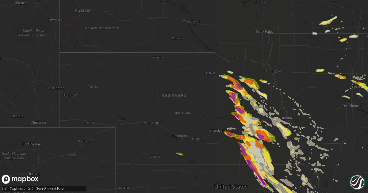
Hail Map in Nebraska on June 16, 2017
Get this storm
June 16 map
$229
one time, instant access
Download today. No call, no setup
Keep the $229
Bought the map and want the full workflow? Apply the entire $229 to a subscription within 7 days. None of it is wasted.
Every map, not just this one
This buys you this map. Subscription and you get every map we run, in the markets you choose from a few cities to whole states to nationwide. Plus real-time alerts the moment a storm fires.
Contact data
Name, contact info, occupancy, even credit band for addresses in the footprint. You go from where it hit to who to call.
Become the source they trust
Unlimited branding weather history reports on demand. You already have the documented answer ready for the property owner, and you are the one who showed up with it.
Property data and RoofTrace estimates
Pull up any address you have got, its value and the exact code rules for that jurisdiction, straight from One Click Code. Then RoofTrace estimates the squares, pitch, and roof value, priced the way you price.
Storm reports in Nebraska
Nebraska
| Date | Description |
|---|---|
| 06/16/20176:54 PM CDT | A local report indicates 1.75 inch wind near MONROE |
| 06/16/20176:52 PM CDT | Quarter to golf ball size hail lasted for about 1 minute. |
| 06/16/20176:52 PM CDT | Quarter to golf ball size hail lasted for about 1 minute. |
| 06/16/20176:50 PM CDT | Report via facebook. |
| 06/16/20176:50 PM CDT | A local report indicates 2.50 inch wind near 5 NNE GENOA |
| 06/16/20176:49 PM CDT | A local report indicates 2.00 inch wind near 5 NNE GENOA |
| 06/16/20176:45 PM CDT | A local report indicates 1.25 inch wind near 8 NE MONROE |
| 06/16/20176:30 PM CDT | A local report indicates 1.00 inch wind near LINDSAY |
| 06/16/20176:23 PM CDT | Roof blown off building. Winds estimated at 60 mph. |
| 06/16/20176:18 PM CDT | A local report indicates 1.00 inch wind near 5 S LINDSAY |
| 06/16/20176:15 PM CDT | A local report indicates 1.50 inch wind near NEWMAN GROVE |
| 06/16/20175:56 PM CDT | Intermittent vortices. |
| 06/16/20175:53 PM CDT | A local report indicates a tornado near 6 E MADISON |
| 06/16/20175:50 PM CDT | Short lived tornado verified by photo and video evidence caused minor tree damage. Total path length approximately 4.5 miles with a peak damage width of around 25 yards |
| 06/16/20175:49 PM CDT | A local report indicates 1.00 inch wind near 5 S NORFOLK |
| 06/16/20175:38 PM CDT | A local report indicates 74 MPH wind near 4 S NORFOLK |
| 06/16/20175:37 PM CDT | A local report indicates 71 MPH wind near 4 S NORFOLK |
| 06/16/20175:32 PM CDT | Near the wayne/stanton county line... Farm hit around 532 pm and ended by 537 pm. A second tornado was seen to the south in pasture land but did not seem to hit anythin |
| 06/16/20175:23 PM CDT | A local report indicates 1.75 inch wind near 1 N BATTLE CREEK |
| 06/16/20175:18 PM CDT | A local report indicates 1.75 inch wind near 6 W NORFOLK |
| 06/16/20175:15 PM CDT | Grain bin destroyed. |
| 06/16/20174:58 PM CDT | A local report indicates 1.25 inch wind near 6 ENE NELIGH |
| 06/16/20174:47 PM CDT | A local report indicates a tornado near 8 N MEADOW GROVE |
| 06/16/20174:23 PM CDT | A local report indicates 1.00 inch wind near BRUNSWICK |
| 06/15/201710:45 PM CDT | Golf ball to baseball size hail. |
| 06/15/201710:27 PM CDT | Crystal springs weather station. |
| 06/15/201710:26 PM CDT | A local report indicates 1.75 inch wind near 4 W FAIRBURY |
| 06/15/201710:25 PM CDT | Quarters to golf balls sized hail. |
| 06/15/201710:21 PM CDT | A local report indicates 1.00 inch wind near 6 W FAIRBURY |
| 06/15/201710:19 PM CDT | A local report indicates 1.75 inch wind near 6 NW FAIRBURY |
| 06/15/201710:11 PM CDT | A local report indicates 1.75 inch wind near 3 E ALEXANDRIA |
| 06/15/20179:50 PM CDT | Quarter sized hail reported 1 e of bruning. |
| 06/15/20179:48 PM CDT | Medium limbs blown down. |
| 06/15/20179:47 PM CDT | A local report indicates 85 MPH wind near 3 N BEATRICE |
| 06/15/20179:42 PM CDT | A local report indicates 80 MPH wind near 6 E PLYMOUTH |
| 06/15/20179:41 PM CDT | Public report of quarter sized hail 3 ese of strang. |
| 06/15/20179:40 PM CDT | Power poles and trees snapped. |
| 06/15/20179:39 PM CDT | Delayed report. Aerial survey by emergency management indicates a 0.9 mile long tornado damage track. The tornado impacted one farm... Destroying an empty grain bin... |
| 06/15/20179:39 PM CDT | A local report indicates 100 MPH wind near 6 NW BEATRICE |
| 06/15/20179:35 PM CDT | Trees blown down onto the road. |
| 06/15/20179:35 PM CDT | Tree and power line damage in town. Time estimated |
| 06/15/20179:35 PM CDT | Nickels to quarters sized hail. |
| 06/15/20179:34 PM CDT | Half inch hail. Substantial tree and power line damage. Pivots flipped. |
| 06/15/20179:15 PM CDT | Very large trees uprooted. Power lines blown down. |
| 06/15/20179:13 PM CDT | A local report indicates 65 MPH wind near WILBER |
| 06/15/20179:12 PM CDT | County reported golf ball sized hail in town with base ball sized hail reported 2 ne of geneva. |
| 06/15/20179:10 PM CDT | Quarters to golf ball sized hail reported. |
| 06/15/20179:06 PM CDT | A local report indicates 1.25 inch wind near CRETE |
| 06/15/20179:05 PM CDT | Two homes damaged from wind on west side of town. Also a couple of homes had lightning damage. |
| 06/15/20179:05 PM CDT | Mobile home lost roof... North side of town. Time estimated. |
| 06/15/20179:04 PM CDT | A local report indicates 60 MPH wind near S DORCHESTER |
| 06/15/20179:04 PM CDT | A local report indicates 60 MPH wind near 5 S DORCHESTER |
| 06/15/20179:04 PM CDT | Hail ongoing. |
| 06/15/20178:57 PM CDT | A local report indicates 63 MPH wind near 4 S DORCHESTER |
| 06/15/20178:55 PM CDT | Nws storm survey confirms a several mile wide swath of wind damage from eastern saline across gage county. One of the most intense damage areas was approximately 3 mile |
| 06/15/20178:50 PM CDT | Several semis flipped in lincoln. |
| 06/15/20178:49 PM CDT | Numeorus reports of trees and power lines down. |
| 06/15/20178:48 PM CDT | At 48th and highway 2. 60 mph winds also. |
| 06/15/20178:40 PM CDT | Also 60 mph wind. |
| 06/15/20178:40 PM CDT | Several semis tipped over just east of 27th street on i-80. Water over roads just south of there as well. |
| 06/15/20178:40 PM CDT | Video footage on facebook of a brief tornado near 48th and leighton on unl east campus. Time estimated by radar. No additional damage information known at this time. |
| 06/15/20178:37 PM CDT | At the lincoln airport. |
| 06/15/20178:35 PM CDT | A local report indicates 70 MPH wind near MALCOLM |
| 06/15/20178:35 PM CDT | A local report indicates 2.00 inch wind near PLEASANT DALE |
| 06/15/20178:33 PM CDT | Near hwy 34 and road v. |
| 06/15/20178:25 PM CDT | A local report indicates 1.00 inch wind near GARLAND |
| 06/15/20178:15 PM CDT | *** 4 inj *** substantial damage in the town. Trees down on most roads. Powerlines blown down. No power between louisville and plattsmouth and weeping water. County mai |
| 06/15/20178:15 PM CDT | Major tree damage. |
| 06/15/20178:10 PM CDT | A local report indicates 80 MPH wind near BELLEVUE |
| 06/15/20178:10 PM CDT | Coffey ave and 31st st. Heavy tree damage - major limbs broken and tops of two trees gone. A limb went through the metal shed roof... And three houses down a tree fell |
| 06/15/20178:10 PM CDT | Significant damage to multiple homes in the hyda hills neighborhood. |
| 06/15/20178:08 PM CDT | Damage survey reveals an ef1 tornado... With a path length around 6.7 miles and maximum width around 175 yards. Moved across offutt air force base with subsequent inter |
| 06/15/20178:06 PM CDT | A local report indicates 70 MPH wind near PAPILLION |
| 06/15/20178:05 PM CDT | Damage survey reveals an ef2 tornado... With a path length around 9.3 miles. Moved through several subdivisions... Including two springs... Pipers glen... Hyda hills... |
| 06/15/20178:04 PM CDT | At omaha airport. |
| 06/15/20178:00 PM CDT | Report and photo received via facebook. Time estimated from radar. |
| 06/15/20178:00 PM CDT | Widepsread tree and fence damage. |
| 06/15/20177:59 PM CDT | 132nd and cornhusker |
| 06/15/20177:59 PM CDT | A local report indicates 74 MPH wind near 4 SSW GRETNA |
| 06/15/20177:58 PM CDT | A local report indicates 80 MPH wind near 1 S GRETNA |
| 06/15/20177:55 PM CDT | 132nd and harrison area. Big trees down along with several fences in the neighbood. |
| 06/15/20177:55 PM CDT | Nws storm survey confirms a large area of wind damage across southern sarpy and adjacent northern cass and western mills counties. One particularly intense area of wind |
| 06/15/20177:55 PM CDT | A local report indicates 70 MPH wind near GRETNA |
| 06/15/20177:53 PM CDT | Numerous trees down and damage to country club |
| 06/15/20177:51 PM CDT | Em reported ping pong hail in osceola. |
| 06/15/20177:50 PM CDT | Report and picture received via facebook. |
| 06/15/20177:50 PM CDT | Trees down. |
| 06/15/20177:50 PM CDT | Nws storm survey confirms a large area of wind damage across southern sarpy and adjacent northern cass and western mills counties. One of the most intense damage areas |
| 06/15/20177:48 PM CDT | A local report indicates 85 MPH wind near 3 NNE GRETNA |
| 06/15/20177:45 PM CDT | A local report indicates 1.75 inch wind near 1 S OSCEOLA |
| 06/15/20177:44 PM CDT | Ongoing and getting more intense. |
| 06/15/20177:40 PM CDT | A local report indicates 70 MPH wind near ELKHORN |
| 06/15/20177:36 PM CDT | At the nws office. |
| 06/15/20177:35 PM CDT | 173rd and f. Numerous trees down and transformers |
| 06/15/20177:35 PM CDT | Fence blown down. |
| 06/15/20177:33 PM CDT | South if i-80 near henderson quarter sized hail. |
| 06/15/20177:32 PM CDT | At the nws office. |
| 06/15/20177:28 PM CDT | 3 s of silver creek. Nws employee reported quarter sized hail. |
| 06/15/20177:25 PM CDT | A local report indicates 110 MPH wind near 2 NW FREMONT |
| 06/15/20177:23 PM CDT | Several trees and powerlines down |
| 06/15/20177:17 PM CDT | A local report indicates 60 MPH wind near FREMONT |
| 06/15/20177:15 PM CDT | Time est by radar. |
| 06/15/20177:15 PM CDT | At the nws office. |
| 06/15/20177:15 PM CDT | Report via em. |
| 06/15/20177:15 PM CDT | Trees and power lines blown down. |
| 06/15/20177:14 PM CDT | Tree branches blown down. |
| 06/15/20177:14 PM CDT | A local report indicates 80 MPH wind near 3 ENE HOOPER |
| 06/15/20177:12 PM CDT | A local report indicates 75 MPH wind near HOOPER |
| 06/15/20177:11 PM CDT | Social media report. |
| 06/15/20177:11 PM CDT | Report via em. |
| 06/15/20177:10 PM CDT | Numerous street signs blown down. |
| 06/15/20177:00 PM CDT | A local report indicates 1.00 inch wind near COLUMBUS |
All States Impacted by Hail Map on June 16, 2017
Cities Impacted by Hail Map on June 16, 2017
- Mount Ayr, IA
- Kellerton, IA
- Monroe, NE
- Platte Center, NE
- Washington, KS
- Morrowville, KS
- Brandon, MS
- Pearl, MS
- Flowood, MS
- Melvern, KS
- Burlingame, KS
- Osage City, KS
- Scranton, KS
- Vassar, KS
- Lebo, KS
- Lyndon, KS
- Lambert, MS
- Vance, MS
- Stewartville, MN
- Silas, AL
- Bolckow, MO
- Savannah, MO
- Rea, MO
- Rosendale, MO
- West Point, NE
- Wisner, NE
- Beemer, NE
- Marvell, AR
- Louisville, MS
- Pomona, KS
- Alden, IA
- Grove Hill, AL
- Mount Horeb, WI
- Verona, WI
- Morton, MS
- Pulaski, MS
- Aurora, NE
- Hampton, NE
- Jackson, MS
- La Cygne, KS
- Parker, KS
- Centerville, KS
- Osawatomie, KS
- Fontana, KS
- Pleasanton, KS
- Mound City, KS
- Florence, MS
- Braxton, MS
- Gresham, WI
- Fairbury, NE
- Waco, NE
- Dorchester, NE
- Frankfort, KS
- Marysville, KS
- Pickrell, NE
- McCool Junction, NE
- Home, KS
- Milford, NE
- Cordova, NE
- Barneston, NE
- Cortland, NE
- Wymore, NE
- Friend, NE
- Clatonia, NE
- Crete, NE
- York, NE
- Wilber, NE
- Filley, NE
- Oketo, KS
- Exeter, NE
- Western, NE
- Liberty, NE
- Beattie, KS
- Virginia, NE
- Beatrice, NE
- Hallam, NE
- Tobias, NE
- De Witt, NE
- Blue Springs, NE
- Bremen, KS
- Milligan, NE
- Beaver Crossing, NE
- Bay Springs, MS
- West Portsmouth, OH
- Stout, OH
- Saint Joseph, MO
- Faucett, MO
- Agency, MO
- Cameron, NC
- Carthage, NC
- Randolph, KS
- Leonardville, KS
- Waterloo, NE
- Yutan, NE
- Itta Bena, MS
- Sidon, MS
- Baldwin City, KS
- Otterbein, IN
- Shawano, WI
- Lanesboro, MN
- Utica, MN
- Fountain, MN
- Chatfield, MN
- Worden, IL
- Edwardsville, IL
- Cochrane, WI
- Arcadia, WI
- Independence, WI
- Alma, WI
- Greenville, MS
- Macon, MS
- Bern, KS
- Sabetha, KS
- Morrill, KS
- Salem, NE
- Oneida, KS
- Dawson, NE
- Rudolph, WI
- Wisconsin Rapids, WI
- Burlington Junction, MO
- Skidmore, MO
- Raleigh, MS
- Fairchild, WI
- Blair, WI
- Willard, WI
- Humbird, WI
- Strum, WI
- Osseo, WI
- Fountain City, WI
- Whitehall, WI
- Alma Center, WI
- Clemons, IA
- State Center, IA
- McCallsburg, IA
- Saint Anthony, IA
- Zearing, IA
- Radcliffe, IA
- Nemaha, NE
- Huntington, IN
- North Manchester, IN
- Mize, MS
- Mount Olive, MS
- Magee, MS
- Caruthersville, MO
- Fairview, MI
- Curran, MI
- Bellwood, NE
- Genoa, NE
- Columbus, NE
- Silver Creek, NE
- Saint Edward, NE
- Lindsay, NE
- Humphrey, NE
- Mahaska, KS
- Daykin, NE
- Reynolds, NE
- Hanover, KS
- Greenleaf, KS
- Alexandria, NE
- Steuben, WI
- Eastman, WI
- Greenfield, MO
- Everton, MO
- Lane, KS
- Rossville, KS
- Viroqua, WI
- Imogene, IA
- Leland, MS
- Manson, IA
- Somers, IA
- Moorland, IA
- Staplehurst, NE
- Utica, NE
- Seward, NE
- Luxora, AR
- Galena, KS
- Columbus, KS
- Jolley, IA
- Pomeroy, IA
- Fonda, IA
- Strang, NE
- McCune, KS
- Coahoma, MS
- Lyon, MS
- Marks, MS
- Harveyville, KS
- Colony, KS
- Mindenmines, MO
- Westphalia, KS
- Iola, KS
- Paxico, KS
- Elsmore, KS
- Stark, KS
- Girard, KS
- Opolis, KS
- Belvue, KS
- Wakarusa, KS
- Webb City, MO
- Asbury, MO
- Quenemo, KS
- Williamsburg, KS
- Carbondale, KS
- Kincaid, KS
- Welda, KS
- Uniontown, KS
- Eskridge, KS
- Baxter Springs, KS
- Richmond, KS
- Hepler, KS
- Saint Paul, KS
- Garnett, KS
- La Harpe, KS
- Erie, KS
- Walnut, KS
- Waverly, KS
- Scammon, KS
- Oronogo, MO
- Cherokee, KS
- Pittsburg, KS
- Wamego, KS
- Joplin, MO
- Carl Junction, MO
- Topeka, KS
- Savonburg, KS
- Moran, KS
- Auburn, KS
- Riverton, KS
- Saint Marys, KS
- Maple Hill, KS
- Weir, KS
- Frontenac, KS
- Stanton, NE
- Pilger, NE
- Holly Grove, AR
- Spring Valley, MN
- Winona, MN
- Greentop, MO
- Maitland, MO
- Madison, MS
- Canton, MS
- Wabasha, MN
- Kellogg, MN
- Altura, MN
- Emmett, KS
- Soldier, KS
- Mayetta, KS
- Delia, KS
- Tunica, MS
- Marianna, AR
- West Lafayette, IN
- West Helena, AR
- Lexa, AR
- Gunnison, MS
- Shelby, MS
- Stromsburg, NE
- Osceola, NE
- Shelby, NE
- Gresham, NE
- Bruning, NE
- Barnes, KS
- Linn, KS
- Waterville, KS
- Blue Rapids, KS
- Hubbell, NE
- Hebron, NE
- Jansen, NE
- Diller, NE
- Steele City, NE
- Olsburg, KS
- Gilead, NE
- Ohiowa, NE
- Hollenberg, KS
- Onaga, KS
- Westmoreland, KS
- Endicott, NE
- Fairmont, NE
- Geneva, NE
- Clintonville, WI
- Shiocton, WI
- Bonduel, WI
- Pierce, NE
- Winside, NE
- Randolph, NE
- Carroll, NE
- Hoskins, NE
- Ossineke, MI
- Sidney, IA
- Farragut, IA
- Riverton, IA
- Tarkio, MO
- Rougemont, NC
- Oxford, NC
- Roxboro, NC
- Timberlake, NC
- Farmersville, IL
- North Bend, NE
- Schuyler, NE
- Clarkson, NE
- Coffeeville, MS
- Minnesota City, MN
- Plainview, MN
- Houston, MS
- Battle Creek, NE
- Madison, NE
- Neligh, NE
- Brunswick, NE
- Plainview, NE
- Royal, NE
- Leigh, NE
- Tilden, NE
- Orchard, NE
- Meadow Grove, NE
- Norfolk, NE
- Dayton, IA
- Lehigh, IA
- Malcolm, NE
- Pleasant Dale, NE
- Raymond, NE
- Martell, NE
- Denton, NE
- Roca, NE
- Davey, NE
- Lincoln, NE
- Rollingstone, MN
- Saint Charles, MN
- Eupora, MS
- Somerville, TN
- Oregon, WI
- Brooklyn, WI
- Belleville, WI
- Barton City, MI
- South Branch, MI
- Malabar, FL
- Palm Bay, FL
- Chatom, AL
- Millry, AL
- Lexington, MS
- Cruger, MS
- Buffalo Center, IA
- Theodore, AL
- Vandalia, IL
- Ramsey, IL
- Newman Grove, NE
- Meridian, MS
- Wagarville, AL
- Goff, KS
- Green Sea, SC
- Cross Plains, WI
- Coila, MS
- Greenwood, MS
- La Grange, TN
- Truman, MN
- Trimont, MN
- Chetopa, KS
- Havensville, KS
- Hoyt, KS
- Silver Lake, KS
- Durant, MS
- Tchula, MS
- Belzoni, MS
- Robinsonville, MS
- Brickeys, AR
- Hughes, AR
- Falls City, NE
- Calhoun City, MS
- Morse Bluff, NE
- Blytheville, AR
- Beulah, MS
- Benoit, MS
- Arkansas City, AR
- Rohwer, AR
- Watson, AR
- Dermott, AR
- State Line, MS
- Buckatunna, MS
- Dodge, NE
- Waynesboro, MS
- Starkville, MS
- Sturgis, MS
- Villisca, IA
- Elliott, IA
- Kingman, IN
- Covington, IN
- Veedersburg, IN
- Portland, AR
- Hamburg, AR
- Parkdale, AR
- Amboy, MN
- Welcome, MN
- Fairmont, MN
- Stoughton, WI
- Garland, NE
- Water Valley, MS
- Belgrade, MO
- Boscobel, WI
- Collins, IA
- Maxwell, IA
- Corning, IA
- New Century, KS
- Lawrence, KS
- Overbrook, KS
- Princeton, KS
- Brainard, NE
- Berryton, KS
- Bee, NE
- Gardner, KS
- Ozawkie, KS
- Bronson, KS
- West Mineral, KS
- Ottawa, KS
- Eudora, KS
- Duncan, NE
- Saint George, KS
- Dwight, NE
- Bennet, NE
- Arma, KS
- De Soto, KS
- Clarks, NE
- Plymouth, NE
- Walton, NE
- Green, KS
- Meriden, KS
- Franklin, KS
- Elgin, NE
- Tonganoxie, KS
- Petersburg, NE
- Valparaiso, NE
- Odell, NE
- Goehner, NE
- Alma, KS
- Lecompton, KS
- Vermillion, KS
- Surprise, NE
- Tecumseh, KS
- Albion, NE
- Bruno, NE
- Manhattan, KS
- David City, NE
- Rising City, NE
- Fullerton, NE
- Perry, KS
- Weston, NE
- Grantville, KS
- Ulysses, NE
- Oakdale, NE
- Linwood, KS
- Olathe, KS
- Casco, WI
- Luxemburg, WI
- Algoma, WI
- Badger, IA
- Baring, MO
- Amazonia, MO
- Cosby, MO
- Easton, MO
- Murray, NE
- Sarah, MS
- Clarksdale, MS
- Forrest City, AR
- Helena, AR
- Dundee, MS
- Sledge, MS
- Crenshaw, MS
- Preston, MN
- Wykoff, MN
- Peterson, MN
- Philadelphia, MS
- Easton, MN
- Delavan, MN
- Birnamwood, WI
- Grand Island, NE
- Blue River, WI
- Kanawha, IA
- Clinton, MO
- Urich, MO
- Montrose, MO
- Boyle, MS
- Shaw, MS
- Doddsville, MS
- Cleveland, MS
- Ridgeland, MS
- Scheller, IL
- La Belle, MO
- Randolph, MS
- Banner, MS
- Cecil, WI
- Helena, MO
- Union Star, MO
- White Hall, IL
- Proctor, AR
- Heth, AR
- Cape Girardeau, MO
- Marquette, NE
- Essex, IA
- Shenandoah, IA
- Salem, WI
- Greenwood, NE
- Ashland, NE
- Wahoo, NE
- Ceresco, NE
- Thomasville, AL
- Lachine, MI
- Herron, MI
- Alpena, MI
- Hillman, MI
- Tillatoba, MS
- Charleston, MS
- Coldwater, MS
- Crawfordsville, AR
- Black River, MI
- Waldo, WI
- Random Lake, WI
- Leroy, AL
- Millington, TN
- Blue Earth, MN
- Rantoul, KS
- Edgerton, KS
- Paola, KS
- Wellsville, KS
- Allegan, MI
- De Soto, WI
- Madrid, IA
- Osage, IA
- Petal, MS
- Blue Mounds, WI
- Brooksville, MS
- Crawford, MS
- Muscoda, WI
- Wauzeka, WI
- Gays Mills, WI
- Platteville, WI
- Eldora, IA
- Steamboat Rock, IA
- Iowa Falls, IA
- Widener, AR
- Bloomingdale, IN
- Mount Hope, WI
- Lockwood, MO
- Tutwiler, MS
- Sherburn, MN
- Comins, MI
- Chunky, MS
- Spavinaw, OK
- Britt, IA
- Duncombe, IA
- Otho, IA
- Stratford, IA
- Fort Dodge, IA
- Caledonia, MI
- Woden, IA
- Thompson, IA
- Columbia, NC
- Loyal, WI
- Ferryville, WI
- Ames, NE
- Louin, MS
- Lake Mills, IA
- Joice, IA
- Elberon, VA
- Ivor, VA
- Smithfield, VA
- Surry, VA
- Livingston, WI
- Belmont, WI
- Lancaster, WI
- Rogers, NE
- Shelby, IA
- Harlan, IA
- Rosedale, MS
- Randolph, IA
- Lucedale, MS
- McLain, MS
- Camden, SC
- Bishopville, SC
- Barneveld, WI
- Chaseburg, WI
- Westby, WI
- Nehawka, NE
- Collinsville, MS
- Union, MS
- Ethel, MS
- McCool, MS
- Sardis, MS
- Como, MS
- Indianola, MS
- Yazoo City, MS
- Stephenson, MI
- Springfield, NE
- Gretna, NE
- Bristol, WI
- Story City, IA
- Mound Bayou, MS
- Saint Louis, MO
- Oakwood, IL
- Shuqualak, MS
- Mayersville, MS
- Rochester, MN
- Eyota, MN
- Elaine, AR
- Chilhowee, MO
- Blairstown, MO
- Carrollton, MS
- Shubert, NE
- New Providence, IA
- Ellsworth, IA
- Hubbard, IA
- Ceylon, MN
- Rocky Mount, NC
- Moselle, MS
- Ovett, MS
- Ellisville, MS
- Marshalltown, IA
- Welch, OK
- Emerson, NE
- Pattonsburg, MO
- Green Bay, WI
- New Franken, WI
- Forestville, WI
- Brussels, WI
- Winona, MS
- Duck Hill, MS
- McCarley, MS
- Newton, MS
- Lawrence, MS
- Eudora, AR
- Hollandale, MS
- Peru, NE
- Nebraska City, NE
- Mobile, AL
- Lake, MS
- Schlater, MS
- Sunflower, MS
- Cedarbluff, MS
- Pheba, MS
- Polk City, IA
- Roland, IA
- Lake Providence, LA
- Pacific Junction, IA
- Glenwood, IA
- Carmi, IL
- Crossville, IL
- Fairview, KS
- Scribner, NE
- Leland, IA
- Shubuta, MS
- Irondale, MO
- Caledonia, MO
- De Kalb, MS
- Scooba, MS
- Steele, MO
- Fort Scott, KS
- Winnetoon, NE
- Creighton, NE
- Everest, KS
- Denton, KS
- Cummings, KS
- Atchison, KS
- Lancaster, KS
- Sheridan, MO
- Pickering, MO
- Hopkins, MO
- Parnell, MO
- Ravenwood, MO
- Gentry, MO
- Stanberry, MO
- Quitman, MS
- Elizabeth City, NC
- South Mills, NC
- Prescott, IA
- Urbana, IN
- South Whitley, IN
- Wilmer, AL
- Cumberland, IA
- Griswold, IA
- Fowler, IN
- Bahama, NC
- Nortonville, KS
- Pollock, MO
- Unionville, MO
- Lucerne, MO
- Henderson, NE
- Cedar Creek, NE
- Louisville, NE
- Rhodes, IA
- Baxter, IA
- Walnut, IA
- Hancock, IA
- Avoca, IA
- Oakland, IA
- Lewis, IA
- Coon Valley, WI
- Thurston, NE
- Taylorsville, MS
- Circleville, KS
- Corning, KS
- Holton, KS
- Waverly, NE
- Vernon Center, MN
- Granada, MN
- Satartia, MS
- Douglas, NE
- Adams, NE
- Merrillan, WI
- Dover, MN
- Vossburg, MS
- Heidelberg, MS
- Clarinda, IA
- New Market, IA
- Madison, WI
- Middleton, WI
- Collins, MS
- Lillington, NC
- Daggett, MI
- Hubbard Lake, MI
- Krakow, WI
- Pulaski, WI
- Hickory, MS
- Decatur, MS
- Prescott, KS
- Mapleton, KS
- Fulton, KS
- Richards, MO
- Hume, MO
- Greeley, KS
- Stewart, MS
- Stilwell, KS
- Rolling Fork, MS
- Isola, MS
- Lansing, KS
- Leavenworth, KS
- Jackson, MO
- Altenburg, MO
- Bowler, WI
- Hopkinton, IA
- Ryan, IA
- Hertford, NC
- Covington, TN
- Holden, MO
- Nodaway, IA
- Verdon, NE
- Rock Port, MO
- Julian, NE
- Fairfax, MO
- Watson, MO
- Stella, NE
- Auburn, NE
- Brock, NE
- Westboro, MO
- Brownville, NE
- Union, NE
- Plattsmouth, NE
- Edina, MO
- Whatley, AL
- Lake Worth, FL
- West Palm Beach, FL
- Oakland, MS
- Richton, MS
- Linwood, NE
- Bartlett, KS
- Knox City, MO
- Osceola, AR
- Little Rock, MS
- McLouth, KS
- Winchester, KS
- Easton, KS
- Cedar Falls, IA
- Afton, OK
- Vinita, OK
- Salisbury, NC
- Mocksville, NC
- Lakota, IA
- Decorah, IA
- Dorchester, IA
- Gallatin, MO
- Jameson, MO
- Kilmichael, MS
- Inverness, MS
- Lake Village, AR
- Titonka, IA
- Alpha, MN
- Spirit Lake, IA
- Jackson, MN
- Estherville, IA
- Hickory Valley, TN
- Whiteville, TN
- Ames, IA
- Palmyra, NE
- Eagle, NE
- Bluffton, IN
- Wayne, NE
- Osmond, NE
- Nickerson, NE
- Fremont, NE
- Hooper, NE
- Denver, MO
- Lena, MS
- Giltner, NE
- Pembine, WI
- Wakefield, NE
- Earle, AR
- Novinger, MO
- Kirksville, MO
- Mikado, MI
- Glennie, MI
- Marion, WI
- Pelahatchie, MS
- Hiawatha, KS
- Horton, KS
- Rushford, MN
- Mound City, MO
- Craig, MO
- Dakota, MN
- Arlington, NE
- Gravity, IA
- Bedford, IA
- Melbourne, IA
- Haverhill, IA
- Union, IA
- Colo, IA
- Albion, IA
- Jewell, IA
- Ripley, TN
- Minden, IA
- Neola, IA
- Neillsville, WI
- Woodward, IA
- Ackerman, MS
- Kosciusko, MS
- Carthage, MS
- Malvern, IA
- Unity, WI
- Spencer, WI
- Greenwood, WI
- Conway, NC
- Troy, TN
- Northwood, IA
- Scarville, IA
- Woodbine, IA
- Pisgah, IA
- Unadilla, NE
- Guilford, MO
- Darlington, MO
- Albany, MO
- Union City, TN
- Denison, KS
- Valley Falls, KS
- Lenox, IA
- Zebulon, NC
- Middlesex, NC
- Logan, IA
- Portsmouth, IA
- Persia, IA
- Emerson, IA
- Hastings, IA
- Oaktown, IN
- Hixton, WI
- Bradshaw, NE
- Burlington, WI
- Champaign, IL
- Walls, MS
- Wolcott, IN
- Brookston, IN
- Remington, IN
- Flora, MS
- Dunnell, MN
- Monroeville, AL
- Lathrop, MO
- South Haven, MI
- Aurora, NC
- Rulo, NE
- Batesville, MS
- Bailey, MS
- Quapaw, OK
- Picher, OK
- Byron Center, MI
- Dorr, MI
- Wayland, MI
- Dyer, TN
- Sturgeon Bay, WI
- Stoddard, WI
- Genoa, WI
- Wetmore, KS
- Powhattan, KS
- Carlisle, IN
- Hopkins, MI
- Otsego, MI
- Martin, MI
- Kansas City, MO
- Kansas City, KS
- Vardaman, MS
- Swanton, NE
- Baileys Harbor, WI
- Keshena, WI
- Effingham, KS
- West Olive, MI
- Lake Cormorant, MS
- Troy, KS
- Conception Junction, MO
- Conception, MO
- Clyde, MO
- Houlka, MS
- Marshall, IN
- Deerfield, MO
- Nevada, MO
- Moundville, MO
- Clinton, MS
- Sainte Genevieve, MO
- Ettrick, WI
- Galesville, WI
- Trempealeau, WI
- Dodge, WI
- Stanhope, IA
- Mississippi State, MS
- Seneca, KS
- Charles City, IA
- Racine, MN
- Oblong, IL
- Sumner, IL
- Blue Mound, KS
- Moorhead, MS
- Weeping Water, NE
- Finleyville, PA
- Clairton, PA
- Onawa, IA
- Blencoe, IA
- Elkhorn, NE
- Avoca, NE
- Colon, NE
- La Vista, NE
- South Bend, NE
- Percival, IA
- Offutt Afb, NE
- Manley, NE
- Papillion, NE
- Omaha, NE
- Dunbar, NE
- Bellevue, NE
- Murdock, NE
- Valley, NE
- Mead, NE
- Thurman, IA
- Otoe, NE
- Fuquay Varina, NC
- Brownsville, TN
- Valley Park, MS
- Bruce, MS
- Lees Summit, MO
- Walthill, NE
- Pender, NE
- Winnebago, NE
- Cook, NE
- Mantee, MS
- Hickman, KY
- Albert Lea, MN
- Glenville, MN
- Hayward, MN
- Kansasville, WI
- Jerico Springs, MO
- Arcola, MO
- Gore Springs, MS
- Delhi, IA
- Sweet Water, AL
- Merigold, MS
- Davis City, IA
- Blythedale, MO
- Bennington, NE
- Kennard, NE
- Eight Mile, AL
- Apex, NC
- Holly Springs, NC
- Renwick, IA
- Belleview, MO
- Oxford, MS
- Holland, MI
- Bellefontaine, MS
- Forest City, IA
- Oxford, NE
- Edison, NE
- Howells, NE
- Cedar Bluffs, NE
- Prague, NE
- Malmo, NE
- Page, NE
- Creston, NE
- Clearwater, NE
- Toxey, AL
- Gilbertown, AL
- Spring Lake, NC
- Export, PA
- Clearmont, MO
- Yorktown, IA
- Coin, IA
- College Springs, IA
- Blanchard, IA
- Braddyville, IA
- Elmo, MO
- Mclean, NE
- Benton, MS
- Dendron, VA
- Williamsburg, VA
- Windsor, VA
- Spring Grove, VA
- Elmore, MN
- Redwood, MS
- Butler, AL
- Council Bluffs, IA
- Syracuse, NE
- Burr, NE
- Fillmore, MO
- Oregon, MO
- Luther, IA
- Boone, IA
- Black River Falls, WI
- Frankville, AL
- Robinson, KS
- Willow Hill, IL
- Fort Stockton, TX
- Emelle, AL
- Tabor, IA
- Sheldon, MO
- Milo, MO
- Lamar, MO
- Atlanta, MI
- Blue Springs, MO
- Red Oak, IA
- Needham, AL
- Oostburg, WI
- Decatur, NE
- Macy, NE
- Woodland, MS
- Rosalie, NE
- Augusta, MO
- Marthasville, MO
- Roper, NC
- Augusta, WI
- Colby, WI
- Jackson, AL
- Ahoskie, NC
- Polo, MO
- Lawson, MO
- Grayville, IL
- Shelbina, MO
- Lamoni, IA
- Palmer, IA
- Orchard, IA
- Saint Ansgar, IA
- Carpenter, IA
- Lumberton, MS
- Chesapeake, VA
- Milford, IL
- Van Wert, OH
- Bluejacket, OK
- King City, MO
- Hernando, MS
- Willow Spring, NC
- Angier, NC
- Webster City, IA
- Arapahoe, NE
- Phillips, NE
- Burchard, NE
- Hickman, NE
- Haddam, KS
- Belvidere, NE
- Spring Hill, KS


