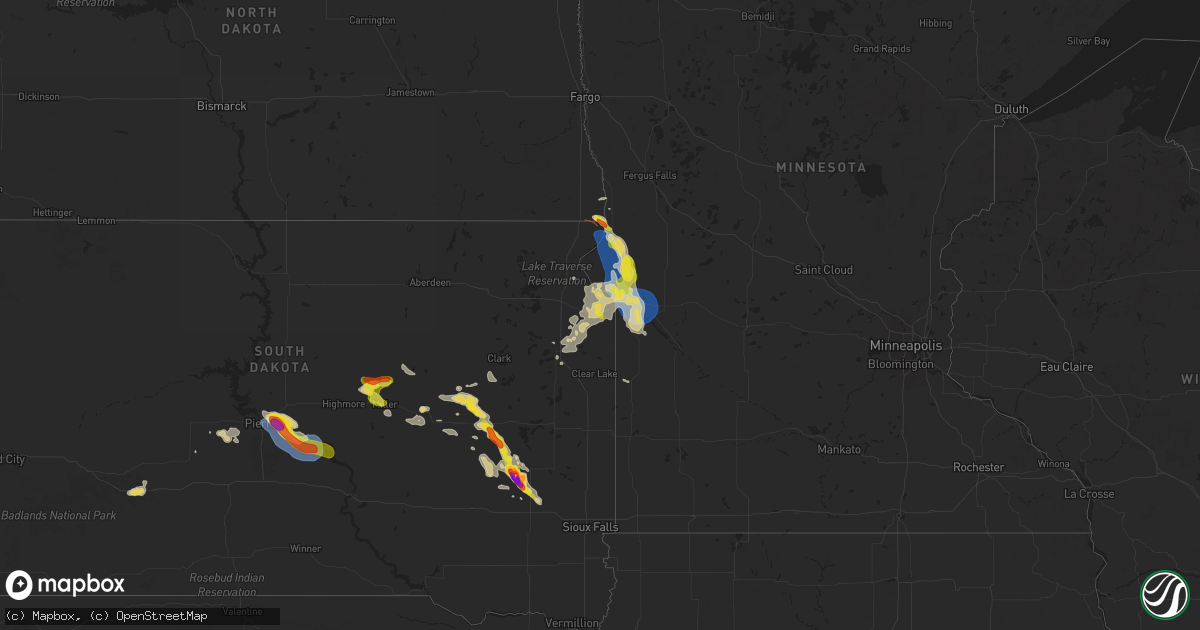
Hail Map on August 21, 2025
Get this storm
August 21 map
$229
one time, instant access
Download today. No call, no setup
Keep the $229
Bought the map and want the full workflow? Apply the entire $229 to a subscription within 7 days. None of it is wasted.
Every map, not just this one
This buys you this map. Subscription and you get every map we run, in the markets you choose from a few cities to whole states to nationwide. Plus real-time alerts the moment a storm fires.
Contact data
Name, contact info, occupancy, even credit band for addresses in the footprint. You go from where it hit to who to call.
Become the source they trust
Unlimited branding weather history reports on demand. You already have the documented answer ready for the property owner, and you are the one who showed up with it.
Property data and RoofTrace estimates
Pull up any address you have got, its value and the exact code rules for that jurisdiction, straight from One Click Code. Then RoofTrace estimates the squares, pitch, and roof value, priced the way you price.
States Impacted by Hail Map on August 21, 2025
Storm reports
Louisiana
| Date | Description |
|---|---|
| 08/21/20253:15 PM CDT | Tree down on the road near hwy 1 and jules dr in donaldsonville. Time estimated by radar. |
| 08/21/20252:56 PM CDT | Powerline down near the intersection of reiley rd and west dubuission rd. Time estimated by radar. |
Arizona
| Date | Description |
|---|---|
| 08/20/202510:21 PM CDT | ***delayed report*** several trees down near 12th street and northern ave. |
| 08/20/202510:20 PM CDT | ***delayed report*** tree fell on top of a couple parked vehicles at a condo near 7th street and northern ave. |
| 08/20/202510:17 PM CDT | Corrects previous tstm wnd gst report from sky harbor airport. Asos station kphx phoenix sky hrbr. |
| 08/20/20258:41 PM CDT | Power lines are down in the area. |
| 08/20/20258:36 PM CDT | Power lines are down in the area. |
| 08/20/20258:36 PM CDT | ***delayed report*** image shows power poles toppled near gold canyon. Location and timing based on outage map report. |
| 08/20/20257:20 PM CDT | Mesonet station srp45 5.3 ne tortilla flat |
South Dakota
| Date | Description |
|---|---|
| 08/21/20255:41 PM CDT | Estimated location of a tornado on the ground. |
| 08/21/20253:35 AM CDT | Estimated 50-60 mph... Lots of leaves ripped off trees... Time estimated from radar. |
| 08/21/20253:29 AM CDT | Asos station kpir pierre muni ap. |
| 08/21/20251:35 AM CDT | Significant damage to vehicles. |
| 08/21/20251:28 AM CDT | Report from mping: half dollar |
| 08/21/202512:22 AM CDT | A local report indicates 1.00 inch wind near 6 NNW Carthage |
| 08/20/20258:38 PM CDT | Report from social media. |
| 08/20/20258:04 PM CDT | A local report indicates 1.00 inch wind near 3 WNW Big Stone City |
Minnesota
| Date | Description |
|---|---|
| 08/21/20256:18 PM CDT | Relayed from emergency manager. Two tornadoes reported... One west of norcross and one northwest of norcross. Tornadoes were reported to be brief. |
| 08/20/20258:04 PM CDT | A local report indicates 1.00 inch wind near 6 SSW Viking |
Florida
| Date | Description |
|---|---|
| 08/21/20254:30 PM CDT | Orlando international airport measured a peak wind gust of 68mph/59kt from the west at 5:30 pm. |
Texas
| Date | Description |
|---|---|
| 08/21/20255:10 PM CDT | Mesonet station 053ce 22 brazos bend. |
| 08/21/20254:40 PM CDT | Report of tree down on county road 352 southeast of henderson. |
Alabama
| Date | Description |
|---|---|
| 08/21/20253:20 PM CDT | Tree down near roeton... Al. |
| 08/21/20252:41 PM CDT | Social media report from the public with photos of multiple power poles snapped in luverne... Al. Time estimated from radar. |
North Dakota
| Date | Description |
|---|---|
| 08/21/20255:50 PM CDT | Tornado visible on dakota magic casino skycam. Location estimated via radar. |
| 08/21/20255:29 PM CDT | Observed tornado riding the north dakota/south dakota state line. |
Georgia
| Date | Description |
|---|---|
| 08/21/20256:39 PM CDT | Mping report: tree limbs and tree uprooted near ga 202. |
| 08/21/20256:30 PM CDT | Corrects previous tstm wnd dmg report from 2 w chastain. Mping report: tree limbs and tree uprooted near ga 202. Time adjusted after confirmation from trained spotter. |
| 08/21/20255:49 PM CDT | Emergency manager reported several trees down east southeast of ludowici along old macon darien road... Hill street... Prince road and stafford dairy road. A few trees |
| 08/21/20255:15 PM CDT | Corrects previous tstm wnd dmg report from little five points. Large tree limbs downed near the intersection of moreland ave and austin ave due to thunderstorm winds. |
| 08/21/20255:15 PM CDT | Corrects previous t |
| 08/21/20254:58 PM CDT | A photo on social media shows a large tree limb blown down near the hamilton e. Holmes marta station. |
Cities Impacted by Hail Map on August 21, 2025
- Salol, MN
- Roseau, MN
- Warroad, MN
- Pompano Beach, FL
- Belle Glade, FL
- Georgetown, TX
- Ponchatoula, LA
- Reagan, TX
- Kosse, TX
- Ashville, AL
- Gadsden, AL
- Jewett, TX
- Flomaton, AL
- Rainbow City, AL
- Bremond, TX
- Marlin, TX
- Wing, AL
- Calvert, TX
- Saint George, GA
- Franklin, TX
- Rosebud, TX
- Slidell, LA
- Glen Saint Mary, FL
- Sanderson, FL
- Geismar, LA
- Darrow, LA
- Gonzales, LA
- Prairieville, LA
- Cameron, TX
- Buckholts, TX
- Statesboro, GA
- Davilla, TX
- Waco, TX
- Brundidge, AL
- Ariton, AL
- Enterprise, AL
- Three Rivers, TX
- Fellsmere, FL
- Milano, TX
- Jack, AL
- Vero Beach, FL
- Donaldsonville, LA
- New Brockton, AL
- Ponte Vedra, FL
- Eufaula, AL
- Ponte Vedra Beach, FL
- Lake City, FL
- Melbourne, FL
- Elm Mott, TX
- Indialantic, FL
- Henderson, TX
- Carthage, TX
- Mount Enterprise, TX
- Long Branch, TX
- Rockledge, FL
- Orlando, FL
- Merritt Island, FL
- Atlanta, GA
- Sinton, TX
- Clifton, AZ
- Alice, TX
- Pontotoc, TX
- Mason, TX
- Blakely, GA
- Pooler, GA
- Bloomingdale, GA
- Mableton, GA
- Laneville, TX
- Savannah, GA
- Robstown, TX
- Art, TX
- Fort Stewart, GA
- Needville, TX
- Damon, TX
- Hinesville, GA
- Palacios, TX
- Bay City, TX
- Reklaw, TX
- Ludowici, GA
- Fairmount, ND
- Pitkin, LA
- Rosholt, SD
- Wheaton, MN
- Rosharon, TX
- Allenhurst, GA
- Mittie, LA
- Alamo, GA
- Hankinson, ND
- Jesup, GA
- Thomasville, GA
- Coolidge, GA
- Tintah, MN
- Pinehurst, TX
- Magnolia, TX
- Dumont, MN
- Ochlocknee, GA
- Wahpeton, ND
- Sugar Land, TX
- Richmond, TX
- Beardsley, MN
- Mitchell, NE
- Meigs, GA
- Hockley, TX
- Houston, TX
- Barry, MN
- Graceville, MN
- Ten Sleep, WY
- Kaycee, WY
- Clinton, MN
- Ortonville, MN
- Chokio, MN
- Corona, SD
- Sulphur, LA
- Big Stone City, SD
- Correll, MN
- Peever, SD
- Viking, MN
- Warren, MN
- Crown King, AZ
- Wilmot, SD
- Fort Mcdowell, AZ
- Odessa, MN
- Thief River Falls, MN
- Appleton, MN
- Roma, TX
- Twin Brooks, SD
- Milbank, SD
- South Shore, SD
- Rio Grande City, TX
- Bellingham, MN
- Holloway, MN
- Clark, SD
- Madison, MN
- Argyle, MN
- Stockholm, SD
- Willow Lake, SD
- Huron, SD
- Strandburg, SD
- Watertown, SD
- Yale, SD
- Superior, AZ
- Goodwin, SD
- Hitchcock, SD
- Iroquois, SD
- Carpenter, SD
- Phoenix, AZ
- Tempe, AZ
- Doland, SD
- Canby, MN
- Hardin, MT
- Cavour, SD
- Miller, SD
- Ree Heights, SD
- Forsyth, MT
- Carthage, SD
- De Smet, SD
- Saint Lawrence, SD
- Redfield, SD
- Rockham, SD
- Howard, SD
- Tulare, SD
- Canova, SD
- Winfred, SD
- Salem, SD
- Wessington, SD
- Kadoka, SD
- Wolsey, SD
- Milesville, SD
- Montrose, SD
- Artesian, SD
- Fedora, SD
- Fort Pierre, SD
- Pierre, SD
- Presho, SD
- Blunt, SD
- Lower Brule, SD
- Harrold, SD
- Spencer, SD
- Kennebec, SD