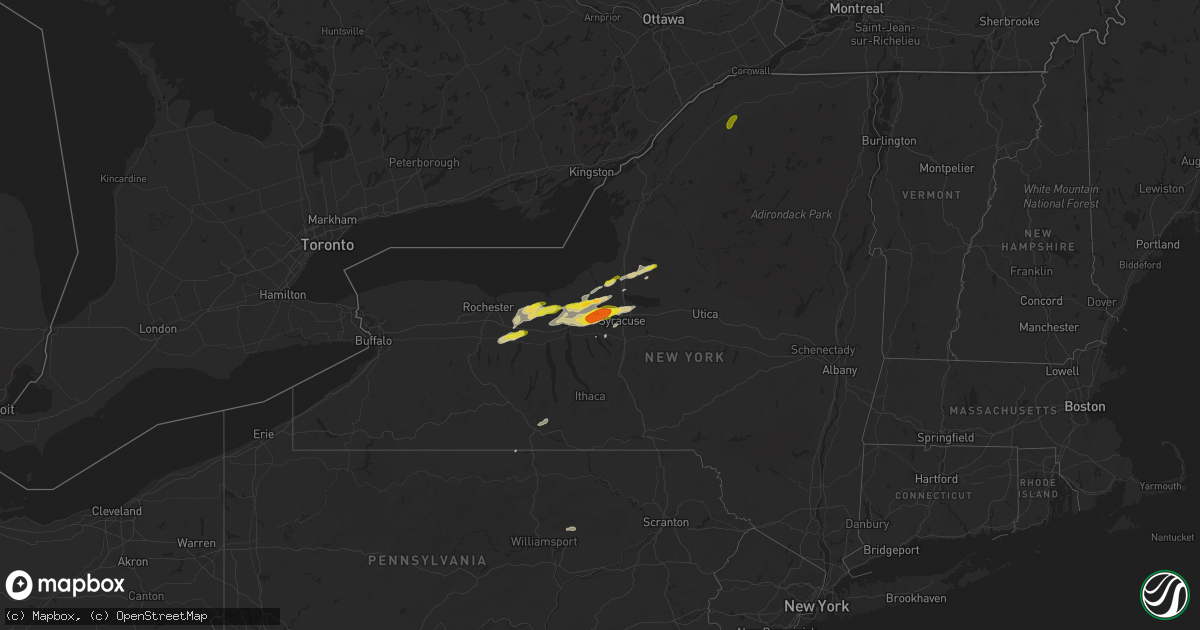
Hail Map on August 24, 2025
Get this storm
August 24 map
$229
one time, instant access
Download today. No call, no setup
Keep the $229
Bought the map and want the full workflow? Apply the entire $229 to a subscription within 7 days. None of it is wasted.
Every map, not just this one
This buys you this map. Subscription and you get every map we run, in the markets you choose from a few cities to whole states to nationwide. Plus real-time alerts the moment a storm fires.
Contact data
Name, contact info, occupancy, even credit band for addresses in the footprint. You go from where it hit to who to call.
Become the source they trust
Unlimited branding weather history reports on demand. You already have the documented answer ready for the property owner, and you are the one who showed up with it.
Property data and RoofTrace estimates
Pull up any address you have got, its value and the exact code rules for that jurisdiction, straight from One Click Code. Then RoofTrace estimates the squares, pitch, and roof value, priced the way you price.
States Impacted by Hail Map on August 24, 2025
Storm reports
Oklahoma
| Date | Description |
|---|---|
| 08/24/20256:35 PM CDT | A local report indicates 99 MPH wind near 4 WNW Camargo |
| 08/24/20256:30 PM CDT | A local report indicates 85 MPH wind near 4 WNW Camargo |
| 08/24/20256:25 PM CDT | A local report indicates 61 MPH wind near 4 WNW Camargo |
| 08/23/20258:00 PM CDT | A local report indicates 58 MPH wind near 4 WNW Bessie |
Pennsylvania
| Date | Description |
|---|---|
| 08/24/20256:36 PM CDT | Tree down across route 381 at old linn run road. Time estimated via radar. |
| 08/24/20256:35 PM CDT | Trees down across the road at the area of rector run road an |
| 08/24/20256:35 PM CDT | Trees down across the road at the area of rector run road and tall tree lane. Time estimated via radar. |
| 08/24/20256:32 PM CDT | Tree down across the road at intersection of hoods mill road and bethel church road. Time estimated via radar. |
| 08/24/20256:30 PM CDT | Tree down along old distillery road at foggy mountain lodge. Time estimated via radar. |
| 08/24/20256:30 PM CDT | Large tree down across hoods mill road blocking the entire roadway. Time estimated via radar. |
Colorado
| Date | Description |
|---|---|
| 08/24/20254:07 PM CDT | Measured gust at fort carson |
| 08/24/20253:45 PM CDT | A local report indicates 1.00 inch wind near 2 W Peterson AFB |
| 08/24/20253:38 PM CDT | A local report indicates 1.75 inch wind near 4 E Arriba |
| 08/24/20253:12 PM CDT | A local report indicates 1.75 inch wind near 10 N Arriba |
| 08/23/20258:38 PM CDT | Asos station klic limon. |
Arizona
| Date | Description |
|---|---|
| 08/24/20254:54 PM CDT | [delayed report] seven power poles knocked down and/or snapped at 2:54 pm mst over salt mine road from damaging downburst winds. Power knocked out for large area of cam |
Nevada
| Date | Description |
|---|---|
| 08/24/20256:57 PM CDT | Asos tonopah airport |
| 08/24/20253:45 PM CDT | Boulder island observed a gust to 59 mph at 1345 followed by a peak gust to 64 mph by 1400. |
Kansas
| Date | Description |
|---|---|
| 08/24/20252:29 PM CDT | A local report indicates 71 MPH wind near 7 NW Bellefont |
| 08/24/20252:14 PM CDT | A local report indicates 63 MPH wind near 9 NNW Offerle |
Texas
| Date | Description |
|---|---|
| 08/23/202511:10 PM CDT | Donley county sher |
| 08/23/202511:10 PM CDT | Donley county sheriff office report |
| 08/23/202511:10 PM CDT | Donley county she |
| 08/23/202511:10 PM CDT | Donley county sheriff office reported irrigation pivots and a barn blown over just northeast of howardwick. Tree branches were also snapped and torn off of trees. |
| 08/23/202511:10 PM CDT | Donley county sheriff office reported irriga |
| 08/23/20259:23 PM CDT | A few intermittent wind gusts occurred at ar |
| 08/23/20259:23 PM CDT | A few intermittent wind gusts occurred at around 60 mph in the 15 minutes before the 82 mph wind gust occurred. |
| 08/23/20257:52 PM CDT | Photo and video sources showed a barn knocked over located wnw of allison. |
Utah
| Date | Description |
|---|---|
| 08/23/202510:15 PM CDT | Mesonet recorded wind gust of 62 mp |
| 08/23/202510:15 PM CDT | Mesonet recorded wind gust of 62 mph at the simpson springs sensor . (sl |
| 08/23/202510:15 PM CDT | Mesonet recorded wind gust of 62 mph at the simpson springs sensor |
| 08/23/202510:15 PM CDT | M |
| 08/23/202510:05 PM CDT | Mesonet recorded wind gust of 63 mph at the playa station sensor |
| 08/23/202510:05 PM CDT | Mesonet recorded wind gust of 65 mph at the target s sensor |
| 08/23/202510:05 PM CDT | Mesonet recorded wind gust of 63 mph at the play |
| 08/23/20259:50 PM CDT | Mesonet recorded wind gust of 59 mph at the horizontal grid sensor |
| 08/23/20259:10 PM CDT | Mesonet recorded gust of 87 mph at the causeway sensor |
| 08/23/20259:00 PM CDT | Mesonet recorded wind gust of 59 mph at callao sensor |
West Virginia
| Date | Description |
|---|---|
| 08/23/20259:45 PM CDT | Tree down on hanger road in belington. |
| 08/23/20259:41 PM CDT | Tree down blocking wb lane along west state ave by the mountaineer mart. Time estimated based off radar. |
| 08/23/20259:20 PM CDT | Top of maple tree snapped off and blocking one lane of buckhannon road. |
| 08/23/20259:20 PM CDT | Couple of lines reported down. |
| 08/23/20259:20 PM CDT | Corrects previous tstm wnd dmg report from 3 sw philippi. Top of maple tree snapped off and blocking one lane of buckhannon road. Time is estimated by radar. |
| 08/23/20259:20 PM CDT | Corrects previous tstm wnd dmg report from 2 sw philippi. Couple of lines reported down. Time is estimated by radar. |
| 08/23/20259:16 PM CDT | Tree down blocking one lane on route 119 in volga. Time estimated from radar. |
| 08/23/20259:16 PM CDT | Corrects previous tstm wnd dmg report from 5 nw audra state park. Tree reported down. Time is estimated by radar. |
| 08/23/20259:16 PM CDT | Tree reported down. |
| 08/23/20258:52 PM CDT | Tree and power lines down blocking the roadway. Time estimated based off radar. |
| 08/23/20258:52 PM CDT | Tree and power lines down blocking the r |
| 08/23/20258:50 PM CDT | Trees and power lines down blocking the road near kingwood pike and cobun creek rd. Time estimated based off radar. |
| 08/23/20258:30 PM CDT | Tree down partially blocking roadway near fairmont rd and hagans rd. Time estimated based off radar. |
| 08/23/20258:06 PM CDT | Tree down. Time estimated from radar. |
| 08/23/20257:26 PM CDT | Tree damage resulting in approximately 20 customers without power. Time is estimated by radar. |
| 08/23/20257:25 PM CDT | Tree damage resulting in approximately 20 customers without power. Time is estimated by radar. |
| 08/23/20257:20 PM CDT | Three trees reported down on nobe road. Time is estimated by radar. |
| 08/23/20257:18 PM CDT | Trees down along broomstick road. Time estimated from radar. |
| 08/23/20257:16 PM CDT | Tree damage resulting in 195 customers without power. Time is estimated by radar. |
| 08/23/20257:16 PM CDT | Several trees down... Some blocking roadway... In several spots along north calhoun highway. Time and location estimated from radar. |
| 08/23/20257:15 PM CDT | Six trees reported down on county route 4 near route 16. Time is estimated by radar. |
| 08/23/20257:14 PM CDT | Tree damage resulting in 619 customers without power. |
New York
| Date | Description |
|---|---|
| 08/24/20254:30 PM CDT | County dispatch fielded a few calls about trees and wires down in town of tully. Radar-estimated time. |
| 08/24/20254:25 PM CDT | Tree and power lines down on highway 11b. |
| 08/24/20254:18 PM CDT | Multiple trees down on west parishville road. |
| 08/24/20254:16 PM CDT | Tree and power lines down on pumpkin hill road. |
| 08/24/20254:16 PM CDT | Power lines down with tree on house on church st. |
| 08/24/20254:11 PM CDT | Tree down blocking butternut ridge rd. |
| 08/24/20253:13 PM CDT | County dispatch fielded multiple calls of trees and wires down in the cicero area... Especially to southeast. Radar-estimated time. |
| 08/24/20253:01 PM CDT | Photo on social med |
| 08/24/20253:01 PM CDT | Picture on social media of a tree down on a house. |
| 08/24/20253:01 PM CDT | Picture on social media |
| 08/24/20253:01 PM CDT | Photo on social media of quarter-sized hail in salina/liverpool. |
| 08/24/20252:56 PM CDT | A local report indicates 1.00 inch wind near 1 N Lakeland |
| 08/24/20252:56 PM CDT | Report from social media. |
| 08/24/20252:54 PM CDT | A tent collapsed outside of gate 4 of the great new york state fair and brought down a utility wire onto sate fair boulevard. An awning of another stand was damaged as |
| 08/24/20252:54 PM CDT | *** 1 inj *** update to previous tstm wnd dmg report. Large tent collapsed outside of gate 4 of the great new york state fair and brought down a utility wire onto state |
| 08/24/20252:50 PM CDT | Tree down on wires. |
| 08/24/20252:46 PM CDT | Picture on social media of several quarter to half dollar sized hail stones along with a quarter for comparison. |
| 08/24/20252:46 PM CDT | Hail size estimated from picture. |
| 08/24/20252:40 PM CDT | Tree down on wires. |
| 08/24/20252:37 PM CDT | Photos of large tree branches down heading toward jordan via social media. |
| 08/24/20252:34 PM CDT | Tree down on wires. |
| 08/24/20252:33 PM CDT | A local report indicates 1.00 inch wind near Jordan |
| 08/24/20252:33 PM CDT | Trees and wires down. |
| 08/24/20252:33 PM CDT | Report on social media of golf ball sized hail near lysander. |
| 08/24/20252:32 PM CDT | Several barns damaged and one destroyed along river road. A few trees on houses and cars. Siding torn off of one house... Garage damage for another. Additional damage o |
| 08/24/20252:21 PM CDT | Several trees down in cato. Time estimated from radar. |
| 08/24/20252:17 PM CDT | Several trees down in weedsport. Time estimated from radar. |
| 08/24/20252:10 PM CDT | Several trees down in port byron. Time estimated from radar. |
| 08/24/20251:57 PM CDT | Reports of multiple trees down in savannah. Time estimated from radar. |
| 08/24/20251:52 PM CDT | Trees down in sodus. Time estimated from radar. |
| 08/24/20251:35 PM CDT | Multiple trees down in the town of acadia. Time estimated from radar. |
| 08/24/20251:35 PM CDT | Multiple calls taken by county dispatch for trees and wires down north and west of baldwinsville. Radar-estimated time. |
| 08/24/20251:15 PM CDT | Tree fell into roadway. |
| 08/24/20251:11 PM CDT | Estimated hail size from picture. Time estimated from radar. |
| 08/24/20251:09 PM CDT | Report of 2 trees down in the town of ira. Time estimated from radar. |
| 08/24/20251:09 PM CDT | Tree down partially blocking oakmount road. |
| 08/24/20251:08 PM CDT | Tree down blocking half of the road. |
| 08/24/20251:04 PM CDT | Report of half of a tree and wires down across state route 444. |
| 08/24/202512:38 PM CDT | Report of 2 trees down in palermo. Time estimated from radar. |
California
| Date | Description |
|---|---|
| 08/24/20255:55 PM CDT | Power lines downed across roadway. Time estimated based on radar. |
| 08/24/20255:50 PM CDT | Pole down//blocking both lanes on brockman time estimated based on radar. |
Cities Impacted by Hail Map on August 24, 2025
- North Platte, NE
- Imperial, NE
- Enders, NE
- Wauneta, NE
- La Crosse, KS
- Nekoma, KS
- Rush Center, KS
- Palisade, NE
- Larned, KS
- Miller, NE
- Sumner, NE
- Brule, NE
- Big Springs, NE
- Marion, NY
- Palmyra, NY
- Newark, NY
- Macedon, NY
- Walworth, NY
- Quinter, KS
- Venango, NE
- Sodus, NY
- Lyons, NY
- Clyde, NY
- North Rose, NY
- Savannah, NY
- Wolcott, NY
- Fulton, NY
- Phoenix, NY
- Central Square, NY
- Parish, NY
- Port Byron, NY
- Red Creek, NY
- Cato, NY
- Mexico, NY
- Bloomfield, NY
- Victor, NY
- Canandaigua, NY
- Farmington, NY
- Shortsville, NY
- Clifton Springs, NY
- Manchester, NY
- Weedsport, NY
- Williamstown, NY
- West Monroe, NY
- Altmar, NY
- Camden, NY
- Redfield, NY
- Hanston, KS
- Waterloo, NY
- Seneca Falls, NY
- Montezuma, NY
- Kinsley, KS
- Jordan, NY
- Elbridge, NY
- Spearville, KS
- Offerle, KS
- Auburn, NY
- Syracuse, NY
- Baldwinsville, NY
- Warners, NY
- Memphis, NY
- Camillus, NY
- Escalante, UT
- Bucklin, KS
- Liverpool, NY
- Greensburg, KS
- Arriba, CO
- Clay, NY
- Flagler, CO
- Cicero, NY
- East Syracuse, NY
- Hannibal, NY
- Hastings, NY
- Colorado Springs, CO
- Pennellville, NY
- Bridgeport, NY
- Cripple Creek, CO
- Martville, NY
- Skaneateles, NY
- Fountain, CO
- Hugo, CO
- Canton, NY
- Potsdam, NY
- Colton, NY
- Pueblo, CO
- Kit Carson, CO
- Kirkland, AZ
- Corning, NY
- Karval, CO
- Beaver Dams, NY
- Horseheads, NY
- Thermal, CA
- Lipscomb, TX
- Higgins, TX
- Canadian, TX
- Rush, CO
- Reydon, OK
- Simla, CO
- Eads, CO
- Vici, OK
- Walsenburg, CO
- Erin, NY
- Sharon, OK
- Arnett, OK
- Ordway, CO
- Briscoe, TX
- Woodward, OK
- Mutual, OK
- Leedey, OK
- Camargo, OK
- Taloga, OK
- Ramah, CO
- Haswell, CO
- Sweetwater, OK
- Butler, OK
- Custer City, OK
- Wheeler, TX
- Sugar City, CO
- Calhan, CO
- Agate, CO
- Durham, OK
- Clinton, OK
- Grantsville, WV
- Big Bend, WV
- Pinon, AZ
- Elkland, PA
- Arapaho, OK
- Shamrock, TX
- Pampa, TX
- Marietta, NY
- Limon, CO
- Bosler, WY
- Foss, OK
- Cordell, OK
- Dill City, OK
- Canute, OK
- Laramie, WY
- Big Springs, WV
- Mobeetie, TX
- Lowman, NY
- Flemington, WV
- Bridgeport, WV
- Genoa, CO
- Dugway, UT
- Wendover, UT
- Woodrow, CO
- Clarendon, TX
- Anton, CO
- Lindon, CO
- Haviland, KS
- Wilmore, KS
- Mullinville, KS
- Muncy Valley, PA
- Hughesville, PA
- Williamsport, PA
- Akron, CO
- Cope, CO
- Yuma, CO
- Addison, NY
- Huntingdon, PA
- Petersburg, PA
- Paw Paw, WV
- Marcellus, NY
- Matheson, CO
- Holyoke, CO
- Sells, AZ
- Grant, NE