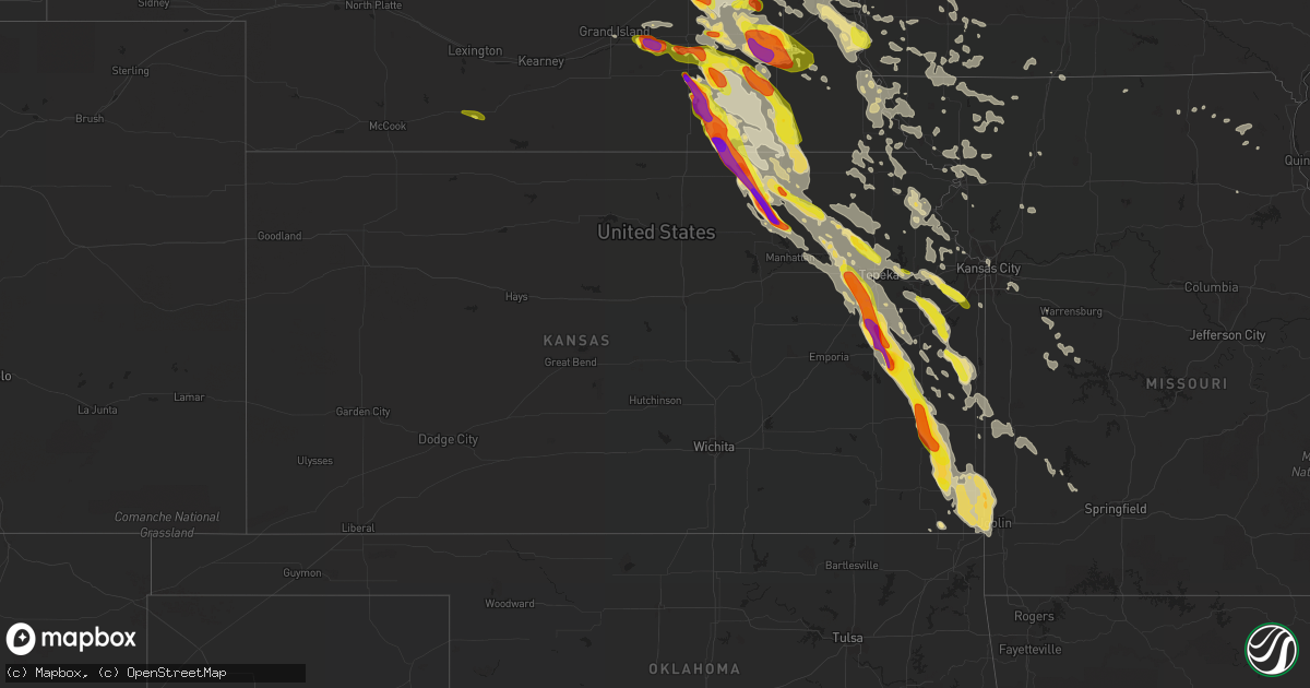
Hail Map in Kansas on June 16, 2017
Get this storm
June 16 map
$229
one time, instant access
Download today. No call, no setup
Keep the $229
Bought the map and want the full workflow? Apply the entire $229 to a subscription within 7 days. None of it is wasted.
Every map, not just this one
This buys you this map. Subscription and you get every map we run, in the markets you choose from a few cities to whole states to nationwide. Plus real-time alerts the moment a storm fires.
Contact data
Name, contact info, occupancy, even credit band for addresses in the footprint. You go from where it hit to who to call.
Become the source they trust
Unlimited branding weather history reports on demand. You already have the documented answer ready for the property owner, and you are the one who showed up with it.
Property data and RoofTrace estimates
Pull up any address you have got, its value and the exact code rules for that jurisdiction, straight from One Click Code. Then RoofTrace estimates the squares, pitch, and roof value, priced the way you price.
Storm reports in Kansas
Kansas
| Date | Description |
|---|---|
| 06/16/20176:46 AM CDT | Large eight inch limbs down and tops blown out of a few trees. |
| 06/16/20176:39 AM CDT | A local report indicates 60 MPH wind near COLUMBUS |
| 06/16/20176:34 AM CDT | Reports of several large limbs down. |
| 06/16/20176:10 AM CDT | Reports of power line down in the 900 block of west 4th street. |
| 06/16/20176:10 AM CDT | Online storm report of large tree limbs/branches down on s chestnut street in pittsburg...ks. |
| 06/16/20175:32 AM CDT | Large tree was reported down blocking north broadway in the 800 block. |
| 06/16/20175:30 AM CDT | Power line reported down at teh intersection of us 69 and leighton street. |
| 06/16/20175:16 AM CDT | Report of a large four inch tree limb snapped off in 400 block of north crawford in frontenac. |
| 06/16/20175:05 AM CDT | A local report indicates 70 MPH wind near MORAN |
| 06/16/20174:48 AM CDT | Estimated 55 to 65 mph winds. |
| 06/16/20174:12 AM CDT | A local report indicates 2.75 inch wind near 5 S WAVERLY |
| 06/16/20173:50 AM CDT | They also had 2.38 of rain. |
| 06/16/20173:38 AM CDT | A large tree was uprooted at 1100 east oak drive and a large limb was downed around 700 national in town. |
| 06/16/20173:35 AM CDT | Time estimated from radar. |
| 06/16/20173:30 AM CDT | A local report indicates 2.50 inch wind near 2 ENE OSAGE CITY |
| 06/16/20173:30 AM CDT | A local report indicates 2.00 inch wind near 1 ENE OSAGE CITY |
| 06/16/20173:30 AM CDT | A local report indicates 2.50 inch wind near LYNDON |
| 06/16/20173:07 AM CDT | A local report indicates 1.00 inch wind near 3 SW AUBURN |
| 06/16/20172:57 AM CDT | Fire department dispatced for large tree down in roadway. |
| 06/16/20172:50 AM CDT | A local report indicates 1.75 inch wind near 2 E DOVER |
| 06/16/20172:46 AM CDT | A local report indicates 1.75 inch wind near LYNDON |
| 06/16/20172:38 AM CDT | A local report indicates 1.00 inch wind near 2 WNW LYNDON |
| 06/16/20171:05 AM CDT | Ixd reported 54 knots. |
| 06/16/20171:04 AM CDT | Ixd reported 50 knots. |
| 06/16/201712:58 AM CDT | Large 4 to 5 inch diameter tree branch snapped off a tree. |
| 06/16/201712:58 AM CDT | 10 inch tree limbs down in 7400 blk sw cannock chase rd. |
| 06/16/201712:56 AM CDT | A local report indicates 1.00 inch wind near 3 E RANDOLPH |
| 06/16/201712:56 AM CDT | 7 inch diameter tree limb snapped... Blocking 2800 blk of sw bingham rd. |
| 06/16/201712:53 AM CDT | A local report indicates 60 MPH wind near 2 ENE CLINTON |
| 06/16/201712:53 AM CDT | 2 inch diameter tree limb down. |
| 06/16/201712:52 AM CDT | Estimated 60 to 70 mph winds gusts. |
| 06/16/201712:44 AM CDT | Via twitter. |
| 06/16/201712:41 AM CDT | A local report indicates 2.75 inch wind near RANDOLPH |
| 06/16/201712:40 AM CDT | Near metcalf ave. And i-435. |
| 06/16/201712:38 AM CDT | A local report indicates 60 MPH wind near 2 NNW LAWRENCE |
| 06/16/201712:35 AM CDT | Large tree limb fell onto car damaging the car on 49th between booth and adams. Time estimated from radar. |
| 06/16/201712:29 AM CDT | A local report indicates 60 MPH wind near LANSING |
| 06/16/201712:28 AM CDT | 60 to 70 mph winds at k-32 and cantrell rd. |
| 06/16/201712:25 AM CDT | 166th st. And stillwell rd. |
| 06/16/201712:23 AM CDT | At the hollywood casino. |
| 06/16/201712:21 AM CDT | Via twitter...considerable tree damage. |
| 06/16/201712:21 AM CDT | A local report indicates 70 MPH wind near 2 E FAIRMOUNT |
| 06/16/201712:18 AM CDT | Power lines down. |
| 06/16/201712:17 AM CDT | A local report indicates 2.75 inch wind near 9 SW WATERVILLE |
| 06/16/201712:16 AM CDT | Power lines down just east of basehor. |
| 06/16/201712:13 AM CDT | 55 to 60 mph. |
| 06/16/201712:13 AM CDT | 55 to 60 mph. |
| 06/16/201712:06 AM CDT | A local report indicates 60 MPH wind near 4 W JARBALO |
| 06/16/201712:04 AM CDT | A local report indicates 1.00 inch wind near 1 W GREENLEAF |
| 06/15/201711:54 PM CDT | Estimated 70 mph winds at marshall rd and k-92. |
| 06/15/201711:53 PM CDT | 6+ inch tree limbs down. |
| 06/15/201711:51 PM CDT | At least 70 mph wind gusts at 134th and us 59. |
| 06/15/201711:47 PM CDT | A local report indicates 2.50 inch wind near 1 SE WASHINGTON |
| 06/15/201711:36 PM CDT | A local report indicates 60 MPH wind near 1 WSW ATCHISON |
| 06/15/201711:35 PM CDT | Nortonville... Ks. |
| 06/15/201711:29 PM CDT | Trees uprooted at 274th and phillips rds. |
| 06/15/201711:24 PM CDT | Windows blown out of storm spotter's truck at kingman and 286th rds. |
| 06/15/201711:23 PM CDT | Via em. |
| 06/15/201711:17 PM CDT | Trees and power lines down in lancaster. |
| 06/15/201711:15 PM CDT | Several 2-4 inch limbs down... Farm equipment blown around. |
| 06/15/201711:15 PM CDT | Several 2 to 4 inch diameter tree branches down... With a few 12 foot long branches down. Estimated 60 mph winds. |
| 06/15/201711:01 PM CDT | Nws storm survey found a short-lived ef-1 tornado from june 16 west of beattie. This tornado tracked to the sse for 2.64 miles and destroyed several outbuilding... Tree |
| 06/15/201710:59 PM CDT | Estimated 60 mph winds and heavy rain reported. Power was reported out in both home city and marysville. |
| 06/15/201710:55 PM CDT | A local report indicates 1.50 inch wind near 8 N MORROWVILLE |
| 06/15/201710:55 PM CDT | A local report indicates 67 MPH wind near 2 NE MARYSVILLE |
| 06/15/201710:53 PM CDT | Power flashes... No power at their location. |
| 06/15/201710:52 PM CDT | Horton lake. 3 rv's blown onto their sides... One blown sideways. Several branches down. Time and speed estimated from radar. |
| 06/15/201710:47 PM CDT | 70 to 75 mph winds with some gusts possibly up to 80 mph. Numerous tree limbs down. |
| 06/15/201710:46 PM CDT | Estimated 60 to 65 mph wind gusts. Numerous tree limbs down... Some 2.5 to 3 inches in diameter. Minor street flooding also reported. |
| 06/15/201710:40 PM CDT | 2 miles w of hwy 77 and state line 2 to 3 sheds have been completely blown down. |
| 06/15/201710:35 PM CDT | Numerous 3+ inch diameter tree limbs down. |
| 06/15/201710:34 PM CDT | A local report indicates 60 MPH wind near 4 NNE BREMEN |
| 06/15/201710:32 PM CDT | A local report indicates 70 MPH wind near 4 SE RESERVE |
| 06/15/201710:21 PM CDT | At 77 highway near the state line. Pulled the hard shell cover of a pickup truck off of the truck. |
All States Impacted by Hail Map on June 16, 2017
Cities Impacted by Hail Map on June 16, 2017
- Mount Ayr, IA
- Kellerton, IA
- Monroe, NE
- Platte Center, NE
- Washington, KS
- Morrowville, KS
- Brandon, MS
- Pearl, MS
- Flowood, MS
- Melvern, KS
- Burlingame, KS
- Osage City, KS
- Scranton, KS
- Vassar, KS
- Lebo, KS
- Lyndon, KS
- Lambert, MS
- Vance, MS
- Stewartville, MN
- Silas, AL
- Bolckow, MO
- Savannah, MO
- Rea, MO
- Rosendale, MO
- West Point, NE
- Wisner, NE
- Beemer, NE
- Marvell, AR
- Louisville, MS
- Pomona, KS
- Alden, IA
- Grove Hill, AL
- Mount Horeb, WI
- Verona, WI
- Morton, MS
- Pulaski, MS
- Aurora, NE
- Hampton, NE
- Jackson, MS
- La Cygne, KS
- Parker, KS
- Centerville, KS
- Osawatomie, KS
- Fontana, KS
- Pleasanton, KS
- Mound City, KS
- Florence, MS
- Braxton, MS
- Gresham, WI
- Fairbury, NE
- Waco, NE
- Dorchester, NE
- Frankfort, KS
- Marysville, KS
- Pickrell, NE
- McCool Junction, NE
- Home, KS
- Milford, NE
- Cordova, NE
- Barneston, NE
- Cortland, NE
- Wymore, NE
- Friend, NE
- Clatonia, NE
- Crete, NE
- York, NE
- Wilber, NE
- Filley, NE
- Oketo, KS
- Exeter, NE
- Western, NE
- Liberty, NE
- Beattie, KS
- Virginia, NE
- Beatrice, NE
- Hallam, NE
- Tobias, NE
- De Witt, NE
- Blue Springs, NE
- Bremen, KS
- Milligan, NE
- Beaver Crossing, NE
- Bay Springs, MS
- West Portsmouth, OH
- Stout, OH
- Saint Joseph, MO
- Faucett, MO
- Agency, MO
- Cameron, NC
- Carthage, NC
- Randolph, KS
- Leonardville, KS
- Waterloo, NE
- Yutan, NE
- Itta Bena, MS
- Sidon, MS
- Baldwin City, KS
- Otterbein, IN
- Shawano, WI
- Lanesboro, MN
- Utica, MN
- Fountain, MN
- Chatfield, MN
- Worden, IL
- Edwardsville, IL
- Cochrane, WI
- Arcadia, WI
- Independence, WI
- Alma, WI
- Greenville, MS
- Macon, MS
- Bern, KS
- Sabetha, KS
- Morrill, KS
- Salem, NE
- Oneida, KS
- Dawson, NE
- Rudolph, WI
- Wisconsin Rapids, WI
- Burlington Junction, MO
- Skidmore, MO
- Raleigh, MS
- Fairchild, WI
- Blair, WI
- Willard, WI
- Humbird, WI
- Strum, WI
- Osseo, WI
- Fountain City, WI
- Whitehall, WI
- Alma Center, WI
- Clemons, IA
- State Center, IA
- McCallsburg, IA
- Saint Anthony, IA
- Zearing, IA
- Radcliffe, IA
- Nemaha, NE
- Huntington, IN
- North Manchester, IN
- Mize, MS
- Mount Olive, MS
- Magee, MS
- Caruthersville, MO
- Fairview, MI
- Curran, MI
- Bellwood, NE
- Genoa, NE
- Columbus, NE
- Silver Creek, NE
- Saint Edward, NE
- Lindsay, NE
- Humphrey, NE
- Mahaska, KS
- Daykin, NE
- Reynolds, NE
- Hanover, KS
- Greenleaf, KS
- Alexandria, NE
- Steuben, WI
- Eastman, WI
- Greenfield, MO
- Everton, MO
- Lane, KS
- Rossville, KS
- Viroqua, WI
- Imogene, IA
- Leland, MS
- Manson, IA
- Somers, IA
- Moorland, IA
- Staplehurst, NE
- Utica, NE
- Seward, NE
- Luxora, AR
- Galena, KS
- Columbus, KS
- Jolley, IA
- Pomeroy, IA
- Fonda, IA
- Strang, NE
- McCune, KS
- Coahoma, MS
- Lyon, MS
- Marks, MS
- Harveyville, KS
- Colony, KS
- Mindenmines, MO
- Westphalia, KS
- Iola, KS
- Paxico, KS
- Elsmore, KS
- Stark, KS
- Girard, KS
- Opolis, KS
- Belvue, KS
- Wakarusa, KS
- Webb City, MO
- Asbury, MO
- Quenemo, KS
- Williamsburg, KS
- Carbondale, KS
- Kincaid, KS
- Welda, KS
- Uniontown, KS
- Eskridge, KS
- Baxter Springs, KS
- Richmond, KS
- Hepler, KS
- Saint Paul, KS
- Garnett, KS
- La Harpe, KS
- Erie, KS
- Walnut, KS
- Waverly, KS
- Scammon, KS
- Oronogo, MO
- Cherokee, KS
- Pittsburg, KS
- Wamego, KS
- Joplin, MO
- Carl Junction, MO
- Topeka, KS
- Savonburg, KS
- Moran, KS
- Auburn, KS
- Riverton, KS
- Saint Marys, KS
- Maple Hill, KS
- Weir, KS
- Frontenac, KS
- Stanton, NE
- Pilger, NE
- Holly Grove, AR
- Spring Valley, MN
- Winona, MN
- Greentop, MO
- Maitland, MO
- Madison, MS
- Canton, MS
- Wabasha, MN
- Kellogg, MN
- Altura, MN
- Emmett, KS
- Soldier, KS
- Mayetta, KS
- Delia, KS
- Tunica, MS
- Marianna, AR
- West Lafayette, IN
- West Helena, AR
- Lexa, AR
- Gunnison, MS
- Shelby, MS
- Stromsburg, NE
- Osceola, NE
- Shelby, NE
- Gresham, NE
- Bruning, NE
- Barnes, KS
- Linn, KS
- Waterville, KS
- Blue Rapids, KS
- Hubbell, NE
- Hebron, NE
- Jansen, NE
- Diller, NE
- Steele City, NE
- Olsburg, KS
- Gilead, NE
- Ohiowa, NE
- Hollenberg, KS
- Onaga, KS
- Westmoreland, KS
- Endicott, NE
- Fairmont, NE
- Geneva, NE
- Clintonville, WI
- Shiocton, WI
- Bonduel, WI
- Pierce, NE
- Winside, NE
- Randolph, NE
- Carroll, NE
- Hoskins, NE
- Ossineke, MI
- Sidney, IA
- Farragut, IA
- Riverton, IA
- Tarkio, MO
- Rougemont, NC
- Oxford, NC
- Roxboro, NC
- Timberlake, NC
- Farmersville, IL
- North Bend, NE
- Schuyler, NE
- Clarkson, NE
- Coffeeville, MS
- Minnesota City, MN
- Plainview, MN
- Houston, MS
- Battle Creek, NE
- Madison, NE
- Neligh, NE
- Brunswick, NE
- Plainview, NE
- Royal, NE
- Leigh, NE
- Tilden, NE
- Orchard, NE
- Meadow Grove, NE
- Norfolk, NE
- Dayton, IA
- Lehigh, IA
- Malcolm, NE
- Pleasant Dale, NE
- Raymond, NE
- Martell, NE
- Denton, NE
- Roca, NE
- Davey, NE
- Lincoln, NE
- Rollingstone, MN
- Saint Charles, MN
- Eupora, MS
- Somerville, TN
- Oregon, WI
- Brooklyn, WI
- Belleville, WI
- Barton City, MI
- South Branch, MI
- Malabar, FL
- Palm Bay, FL
- Chatom, AL
- Millry, AL
- Lexington, MS
- Cruger, MS
- Buffalo Center, IA
- Theodore, AL
- Vandalia, IL
- Ramsey, IL
- Newman Grove, NE
- Meridian, MS
- Wagarville, AL
- Goff, KS
- Green Sea, SC
- Cross Plains, WI
- Coila, MS
- Greenwood, MS
- La Grange, TN
- Truman, MN
- Trimont, MN
- Chetopa, KS
- Havensville, KS
- Hoyt, KS
- Silver Lake, KS
- Durant, MS
- Tchula, MS
- Belzoni, MS
- Robinsonville, MS
- Brickeys, AR
- Hughes, AR
- Falls City, NE
- Calhoun City, MS
- Morse Bluff, NE
- Blytheville, AR
- Beulah, MS
- Benoit, MS
- Arkansas City, AR
- Rohwer, AR
- Watson, AR
- Dermott, AR
- State Line, MS
- Buckatunna, MS
- Dodge, NE
- Waynesboro, MS
- Starkville, MS
- Sturgis, MS
- Villisca, IA
- Elliott, IA
- Kingman, IN
- Covington, IN
- Veedersburg, IN
- Portland, AR
- Hamburg, AR
- Parkdale, AR
- Amboy, MN
- Welcome, MN
- Fairmont, MN
- Stoughton, WI
- Garland, NE
- Water Valley, MS
- Belgrade, MO
- Boscobel, WI
- Collins, IA
- Maxwell, IA
- Corning, IA
- New Century, KS
- Lawrence, KS
- Overbrook, KS
- Princeton, KS
- Brainard, NE
- Berryton, KS
- Bee, NE
- Gardner, KS
- Ozawkie, KS
- Bronson, KS
- West Mineral, KS
- Ottawa, KS
- Eudora, KS
- Duncan, NE
- Saint George, KS
- Dwight, NE
- Bennet, NE
- Arma, KS
- De Soto, KS
- Clarks, NE
- Plymouth, NE
- Walton, NE
- Green, KS
- Meriden, KS
- Franklin, KS
- Elgin, NE
- Tonganoxie, KS
- Petersburg, NE
- Valparaiso, NE
- Odell, NE
- Goehner, NE
- Alma, KS
- Lecompton, KS
- Vermillion, KS
- Surprise, NE
- Tecumseh, KS
- Albion, NE
- Bruno, NE
- Manhattan, KS
- David City, NE
- Rising City, NE
- Fullerton, NE
- Perry, KS
- Weston, NE
- Grantville, KS
- Ulysses, NE
- Oakdale, NE
- Linwood, KS
- Olathe, KS
- Casco, WI
- Luxemburg, WI
- Algoma, WI
- Badger, IA
- Baring, MO
- Amazonia, MO
- Cosby, MO
- Easton, MO
- Murray, NE
- Sarah, MS
- Clarksdale, MS
- Forrest City, AR
- Helena, AR
- Dundee, MS
- Sledge, MS
- Crenshaw, MS
- Preston, MN
- Wykoff, MN
- Peterson, MN
- Philadelphia, MS
- Easton, MN
- Delavan, MN
- Birnamwood, WI
- Grand Island, NE
- Blue River, WI
- Kanawha, IA
- Clinton, MO
- Urich, MO
- Montrose, MO
- Boyle, MS
- Shaw, MS
- Doddsville, MS
- Cleveland, MS
- Ridgeland, MS
- Scheller, IL
- La Belle, MO
- Randolph, MS
- Banner, MS
- Cecil, WI
- Helena, MO
- Union Star, MO
- White Hall, IL
- Proctor, AR
- Heth, AR
- Cape Girardeau, MO
- Marquette, NE
- Essex, IA
- Shenandoah, IA
- Salem, WI
- Greenwood, NE
- Ashland, NE
- Wahoo, NE
- Ceresco, NE
- Thomasville, AL
- Lachine, MI
- Herron, MI
- Alpena, MI
- Hillman, MI
- Tillatoba, MS
- Charleston, MS
- Coldwater, MS
- Crawfordsville, AR
- Black River, MI
- Waldo, WI
- Random Lake, WI
- Leroy, AL
- Millington, TN
- Blue Earth, MN
- Rantoul, KS
- Edgerton, KS
- Paola, KS
- Wellsville, KS
- Allegan, MI
- De Soto, WI
- Madrid, IA
- Osage, IA
- Petal, MS
- Blue Mounds, WI
- Brooksville, MS
- Crawford, MS
- Muscoda, WI
- Wauzeka, WI
- Gays Mills, WI
- Platteville, WI
- Eldora, IA
- Steamboat Rock, IA
- Iowa Falls, IA
- Widener, AR
- Bloomingdale, IN
- Mount Hope, WI
- Lockwood, MO
- Tutwiler, MS
- Sherburn, MN
- Comins, MI
- Chunky, MS
- Spavinaw, OK
- Britt, IA
- Duncombe, IA
- Otho, IA
- Stratford, IA
- Fort Dodge, IA
- Caledonia, MI
- Woden, IA
- Thompson, IA
- Columbia, NC
- Loyal, WI
- Ferryville, WI
- Ames, NE
- Louin, MS
- Lake Mills, IA
- Joice, IA
- Elberon, VA
- Ivor, VA
- Smithfield, VA
- Surry, VA
- Livingston, WI
- Belmont, WI
- Lancaster, WI
- Rogers, NE
- Shelby, IA
- Harlan, IA
- Rosedale, MS
- Randolph, IA
- Lucedale, MS
- McLain, MS
- Camden, SC
- Bishopville, SC
- Barneveld, WI
- Chaseburg, WI
- Westby, WI
- Nehawka, NE
- Collinsville, MS
- Union, MS
- Ethel, MS
- McCool, MS
- Sardis, MS
- Como, MS
- Indianola, MS
- Yazoo City, MS
- Stephenson, MI
- Springfield, NE
- Gretna, NE
- Bristol, WI
- Story City, IA
- Mound Bayou, MS
- Saint Louis, MO
- Oakwood, IL
- Shuqualak, MS
- Mayersville, MS
- Rochester, MN
- Eyota, MN
- Elaine, AR
- Chilhowee, MO
- Blairstown, MO
- Carrollton, MS
- Shubert, NE
- New Providence, IA
- Ellsworth, IA
- Hubbard, IA
- Ceylon, MN
- Rocky Mount, NC
- Moselle, MS
- Ovett, MS
- Ellisville, MS
- Marshalltown, IA
- Welch, OK
- Emerson, NE
- Pattonsburg, MO
- Green Bay, WI
- New Franken, WI
- Forestville, WI
- Brussels, WI
- Winona, MS
- Duck Hill, MS
- McCarley, MS
- Newton, MS
- Lawrence, MS
- Eudora, AR
- Hollandale, MS
- Peru, NE
- Nebraska City, NE
- Mobile, AL
- Lake, MS
- Schlater, MS
- Sunflower, MS
- Cedarbluff, MS
- Pheba, MS
- Polk City, IA
- Roland, IA
- Lake Providence, LA
- Pacific Junction, IA
- Glenwood, IA
- Carmi, IL
- Crossville, IL
- Fairview, KS
- Scribner, NE
- Leland, IA
- Shubuta, MS
- Irondale, MO
- Caledonia, MO
- De Kalb, MS
- Scooba, MS
- Steele, MO
- Fort Scott, KS
- Winnetoon, NE
- Creighton, NE
- Everest, KS
- Denton, KS
- Cummings, KS
- Atchison, KS
- Lancaster, KS
- Sheridan, MO
- Pickering, MO
- Hopkins, MO
- Parnell, MO
- Ravenwood, MO
- Gentry, MO
- Stanberry, MO
- Quitman, MS
- Elizabeth City, NC
- South Mills, NC
- Prescott, IA
- Urbana, IN
- South Whitley, IN
- Wilmer, AL
- Cumberland, IA
- Griswold, IA
- Fowler, IN
- Bahama, NC
- Nortonville, KS
- Pollock, MO
- Unionville, MO
- Lucerne, MO
- Henderson, NE
- Cedar Creek, NE
- Louisville, NE
- Rhodes, IA
- Baxter, IA
- Walnut, IA
- Hancock, IA
- Avoca, IA
- Oakland, IA
- Lewis, IA
- Coon Valley, WI
- Thurston, NE
- Taylorsville, MS
- Circleville, KS
- Corning, KS
- Holton, KS
- Waverly, NE
- Vernon Center, MN
- Granada, MN
- Satartia, MS
- Douglas, NE
- Adams, NE
- Merrillan, WI
- Dover, MN
- Vossburg, MS
- Heidelberg, MS
- Clarinda, IA
- New Market, IA
- Madison, WI
- Middleton, WI
- Collins, MS
- Lillington, NC
- Daggett, MI
- Hubbard Lake, MI
- Krakow, WI
- Pulaski, WI
- Hickory, MS
- Decatur, MS
- Prescott, KS
- Mapleton, KS
- Fulton, KS
- Richards, MO
- Hume, MO
- Greeley, KS
- Stewart, MS
- Stilwell, KS
- Rolling Fork, MS
- Isola, MS
- Lansing, KS
- Leavenworth, KS
- Jackson, MO
- Altenburg, MO
- Bowler, WI
- Hopkinton, IA
- Ryan, IA
- Hertford, NC
- Covington, TN
- Holden, MO
- Nodaway, IA
- Verdon, NE
- Rock Port, MO
- Julian, NE
- Fairfax, MO
- Watson, MO
- Stella, NE
- Auburn, NE
- Brock, NE
- Westboro, MO
- Brownville, NE
- Union, NE
- Plattsmouth, NE
- Edina, MO
- Whatley, AL
- Lake Worth, FL
- West Palm Beach, FL
- Oakland, MS
- Richton, MS
- Linwood, NE
- Bartlett, KS
- Knox City, MO
- Osceola, AR
- Little Rock, MS
- McLouth, KS
- Winchester, KS
- Easton, KS
- Cedar Falls, IA
- Afton, OK
- Vinita, OK
- Salisbury, NC
- Mocksville, NC
- Lakota, IA
- Decorah, IA
- Dorchester, IA
- Gallatin, MO
- Jameson, MO
- Kilmichael, MS
- Inverness, MS
- Lake Village, AR
- Titonka, IA
- Alpha, MN
- Spirit Lake, IA
- Jackson, MN
- Estherville, IA
- Hickory Valley, TN
- Whiteville, TN
- Ames, IA
- Palmyra, NE
- Eagle, NE
- Bluffton, IN
- Wayne, NE
- Osmond, NE
- Nickerson, NE
- Fremont, NE
- Hooper, NE
- Denver, MO
- Lena, MS
- Giltner, NE
- Pembine, WI
- Wakefield, NE
- Earle, AR
- Novinger, MO
- Kirksville, MO
- Mikado, MI
- Glennie, MI
- Marion, WI
- Pelahatchie, MS
- Hiawatha, KS
- Horton, KS
- Rushford, MN
- Mound City, MO
- Craig, MO
- Dakota, MN
- Arlington, NE
- Gravity, IA
- Bedford, IA
- Melbourne, IA
- Haverhill, IA
- Union, IA
- Colo, IA
- Albion, IA
- Jewell, IA
- Ripley, TN
- Minden, IA
- Neola, IA
- Neillsville, WI
- Woodward, IA
- Ackerman, MS
- Kosciusko, MS
- Carthage, MS
- Malvern, IA
- Unity, WI
- Spencer, WI
- Greenwood, WI
- Conway, NC
- Troy, TN
- Northwood, IA
- Scarville, IA
- Woodbine, IA
- Pisgah, IA
- Unadilla, NE
- Guilford, MO
- Darlington, MO
- Albany, MO
- Union City, TN
- Denison, KS
- Valley Falls, KS
- Lenox, IA
- Zebulon, NC
- Middlesex, NC
- Logan, IA
- Portsmouth, IA
- Persia, IA
- Emerson, IA
- Hastings, IA
- Oaktown, IN
- Hixton, WI
- Bradshaw, NE
- Burlington, WI
- Champaign, IL
- Walls, MS
- Wolcott, IN
- Brookston, IN
- Remington, IN
- Flora, MS
- Dunnell, MN
- Monroeville, AL
- Lathrop, MO
- South Haven, MI
- Aurora, NC
- Rulo, NE
- Batesville, MS
- Bailey, MS
- Quapaw, OK
- Picher, OK
- Byron Center, MI
- Dorr, MI
- Wayland, MI
- Dyer, TN
- Sturgeon Bay, WI
- Stoddard, WI
- Genoa, WI
- Wetmore, KS
- Powhattan, KS
- Carlisle, IN
- Hopkins, MI
- Otsego, MI
- Martin, MI
- Kansas City, MO
- Kansas City, KS
- Vardaman, MS
- Swanton, NE
- Baileys Harbor, WI
- Keshena, WI
- Effingham, KS
- West Olive, MI
- Lake Cormorant, MS
- Troy, KS
- Conception Junction, MO
- Conception, MO
- Clyde, MO
- Houlka, MS
- Marshall, IN
- Deerfield, MO
- Nevada, MO
- Moundville, MO
- Clinton, MS
- Sainte Genevieve, MO
- Ettrick, WI
- Galesville, WI
- Trempealeau, WI
- Dodge, WI
- Stanhope, IA
- Mississippi State, MS
- Seneca, KS
- Charles City, IA
- Racine, MN
- Oblong, IL
- Sumner, IL
- Blue Mound, KS
- Moorhead, MS
- Weeping Water, NE
- Finleyville, PA
- Clairton, PA
- Onawa, IA
- Blencoe, IA
- Elkhorn, NE
- Avoca, NE
- Colon, NE
- La Vista, NE
- South Bend, NE
- Percival, IA
- Offutt Afb, NE
- Manley, NE
- Papillion, NE
- Omaha, NE
- Dunbar, NE
- Bellevue, NE
- Murdock, NE
- Valley, NE
- Mead, NE
- Thurman, IA
- Otoe, NE
- Fuquay Varina, NC
- Brownsville, TN
- Valley Park, MS
- Bruce, MS
- Lees Summit, MO
- Walthill, NE
- Pender, NE
- Winnebago, NE
- Cook, NE
- Mantee, MS
- Hickman, KY
- Albert Lea, MN
- Glenville, MN
- Hayward, MN
- Kansasville, WI
- Jerico Springs, MO
- Arcola, MO
- Gore Springs, MS
- Delhi, IA
- Sweet Water, AL
- Merigold, MS
- Davis City, IA
- Blythedale, MO
- Bennington, NE
- Kennard, NE
- Eight Mile, AL
- Apex, NC
- Holly Springs, NC
- Renwick, IA
- Belleview, MO
- Oxford, MS
- Holland, MI
- Bellefontaine, MS
- Forest City, IA
- Oxford, NE
- Edison, NE
- Howells, NE
- Cedar Bluffs, NE
- Prague, NE
- Malmo, NE
- Page, NE
- Creston, NE
- Clearwater, NE
- Toxey, AL
- Gilbertown, AL
- Spring Lake, NC
- Export, PA
- Clearmont, MO
- Yorktown, IA
- Coin, IA
- College Springs, IA
- Blanchard, IA
- Braddyville, IA
- Elmo, MO
- Mclean, NE
- Benton, MS
- Dendron, VA
- Williamsburg, VA
- Windsor, VA
- Spring Grove, VA
- Elmore, MN
- Redwood, MS
- Butler, AL
- Council Bluffs, IA
- Syracuse, NE
- Burr, NE
- Fillmore, MO
- Oregon, MO
- Luther, IA
- Boone, IA
- Black River Falls, WI
- Frankville, AL
- Robinson, KS
- Willow Hill, IL
- Fort Stockton, TX
- Emelle, AL
- Tabor, IA
- Sheldon, MO
- Milo, MO
- Lamar, MO
- Atlanta, MI
- Blue Springs, MO
- Red Oak, IA
- Needham, AL
- Oostburg, WI
- Decatur, NE
- Macy, NE
- Woodland, MS
- Rosalie, NE
- Augusta, MO
- Marthasville, MO
- Roper, NC
- Augusta, WI
- Colby, WI
- Jackson, AL
- Ahoskie, NC
- Polo, MO
- Lawson, MO
- Grayville, IL
- Shelbina, MO
- Lamoni, IA
- Palmer, IA
- Orchard, IA
- Saint Ansgar, IA
- Carpenter, IA
- Lumberton, MS
- Chesapeake, VA
- Milford, IL
- Van Wert, OH
- Bluejacket, OK
- King City, MO
- Hernando, MS
- Willow Spring, NC
- Angier, NC
- Webster City, IA
- Arapahoe, NE
- Phillips, NE
- Burchard, NE
- Hickman, NE
- Haddam, KS
- Belvidere, NE
- Spring Hill, KS


