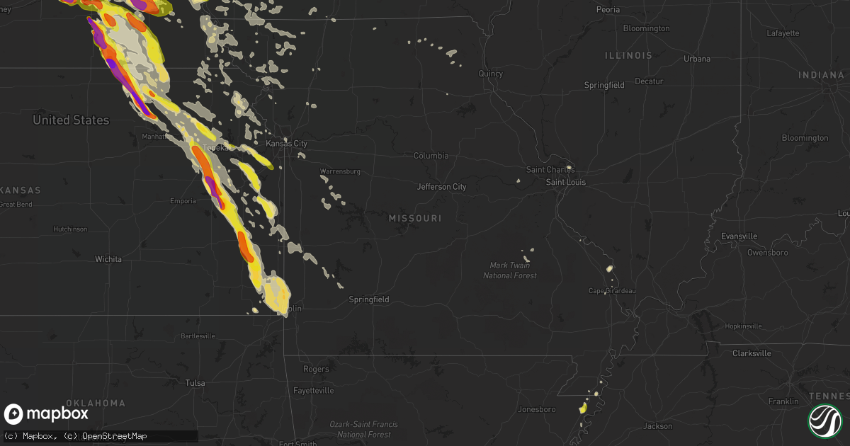
Hail Map in Missouri on June 16, 2017
Get this storm
June 16 map
$229
one time, instant access
Download today. No call, no setup
Keep the $229
Bought the map and want the full workflow? Apply the entire $229 to a subscription within 7 days. None of it is wasted.
Every map, not just this one
This buys you this map. Subscription and you get every map we run, in the markets you choose from a few cities to whole states to nationwide. Plus real-time alerts the moment a storm fires.
Contact data
Name, contact info, occupancy, even credit band for addresses in the footprint. You go from where it hit to who to call.
Become the source they trust
Unlimited branding weather history reports on demand. You already have the documented answer ready for the property owner, and you are the one who showed up with it.
Property data and RoofTrace estimates
Pull up any address you have got, its value and the exact code rules for that jurisdiction, straight from One Click Code. Then RoofTrace estimates the squares, pitch, and roof value, priced the way you price.
Storm reports in Missouri
Missouri
| Date | Description |
|---|---|
| 06/16/20175:55 AM CDT | Tree down on fountain road. |
| 06/16/20173:59 AM CDT | Tree down blocking delaware ave and prairie creek drive. |
| 06/16/20173:41 AM CDT | Reports of several trees and power poles blown down or broken. Some minor damage to a few barns also reported. |
| 06/16/20173:00 AM CDT | Tree down partially blocking the roadway near nemo on state highway nn. |
| 06/16/20172:20 AM CDT | Multiple trees down in the city of clinton. |
| 06/16/20172:17 AM CDT | Limbs down hwy a. |
| 06/16/20172:00 AM CDT | Trees down of unknown size throughout morgan county per dispatch. |
| 06/16/20171:00 AM CDT | 38 customers without power and a few trees down in sedalia. Winds were around 8mph at the airport but ema spotter reported 54mph in la monte about 10 minutes prior. |
| 06/16/201712:30 AM CDT | Mci reported 56 knots. |
| 06/16/201712:24 AM CDT | Mci reported 55 knots. |
| 06/16/201712:07 AM CDT | 1.5 ft diameter hollowed tree snapped... Numerous other smaller branches downed. |
| 06/16/201712:00 AM CDT | Structural damage to school and crops. |
| 06/15/201711:58 PM CDT | Approximately two foot branch snapped off and pushed against north exterior wall of lafayette regional health center. No damage reported to hospital. Multiple lines dow |
| 06/15/201711:47 PM CDT | Em relayed report of tree down blocking the road near hwy 59 and dd in country club village. |
| 06/15/201711:45 PM CDT | Via twitter...very large tree down. |
| 06/15/201711:29 PM CDT | A local report indicates 65 MPH wind near 3 E TURNEY |
| 06/15/201711:22 PM CDT | Reported damage to a house near nw 296th st. And nw hwy y. |
| 06/15/201711:22 PM CDT | Est. 65 to 70 mph winds. |
| 06/15/201711:17 PM CDT | Hwy 33 north of 280th st is blocked due to a large tree down. |
| 06/15/201711:17 PM CDT | Damage to a fertilizer structure reported at sur-gro. |
| 06/15/201711:17 PM CDT | Hwy 116 near birch st. Closed due to live powerline across the road... Along with numerous trees and limbs down throughout the city. |
| 06/15/201711:14 PM CDT | Relayed via broadcast media. |
| 06/15/201711:10 PM CDT | 55-60mph near hwy 33 and 305th st. |
| 06/15/201711:02 PM CDT | 50 to 60 mph winds estimated 3 miles west of stewartsville. |
| 06/15/201710:56 PM CDT | Estimated 50 to 60 mph winds per firefighter. |
| 06/15/201710:53 PM CDT | A local report indicates 70 MPH wind near GILMAN CITY |
| 06/15/201710:51 PM CDT | Tree across cook rd east of i-29. |
| 06/15/201710:48 PM CDT | Estimated time. Recorded at a wind farm about 3 miles south of the mo/ia border. No estimation on the height of the measurement. |
| 06/15/201710:47 PM CDT | 66 knots reported at stj. |
| 06/15/201710:47 PM CDT | Numerous trees and power lines down in the city. |
| 06/15/201710:40 PM CDT | 60 to 70 mph winds reported in rosendale per emd. |
| 06/15/201710:26 PM CDT | 75-80 mph winds reported from south holt fire in oregon. |
| 06/15/201710:13 PM CDT | Large tree blocking the road on henley st. In albany. |
| 06/15/201710:00 PM CDT | A local report indicates 70 MPH wind near GRANT CITY |
| 06/15/20179:49 PM CDT | Camper blown into mozingo lake with a possible occupant inside. |
| 06/15/20179:40 PM CDT | Trees down in tarkio. |
All States Impacted by Hail Map on June 16, 2017
Cities Impacted by Hail Map on June 16, 2017
- Mount Ayr, IA
- Kellerton, IA
- Monroe, NE
- Platte Center, NE
- Washington, KS
- Morrowville, KS
- Brandon, MS
- Pearl, MS
- Flowood, MS
- Melvern, KS
- Burlingame, KS
- Osage City, KS
- Scranton, KS
- Vassar, KS
- Lebo, KS
- Lyndon, KS
- Lambert, MS
- Vance, MS
- Stewartville, MN
- Silas, AL
- Bolckow, MO
- Savannah, MO
- Rea, MO
- Rosendale, MO
- West Point, NE
- Wisner, NE
- Beemer, NE
- Marvell, AR
- Louisville, MS
- Pomona, KS
- Alden, IA
- Grove Hill, AL
- Mount Horeb, WI
- Verona, WI
- Morton, MS
- Pulaski, MS
- Aurora, NE
- Hampton, NE
- Jackson, MS
- La Cygne, KS
- Parker, KS
- Centerville, KS
- Osawatomie, KS
- Fontana, KS
- Pleasanton, KS
- Mound City, KS
- Florence, MS
- Braxton, MS
- Gresham, WI
- Fairbury, NE
- Waco, NE
- Dorchester, NE
- Frankfort, KS
- Marysville, KS
- Pickrell, NE
- McCool Junction, NE
- Home, KS
- Milford, NE
- Cordova, NE
- Barneston, NE
- Cortland, NE
- Wymore, NE
- Friend, NE
- Clatonia, NE
- Crete, NE
- York, NE
- Wilber, NE
- Filley, NE
- Oketo, KS
- Exeter, NE
- Western, NE
- Liberty, NE
- Beattie, KS
- Virginia, NE
- Beatrice, NE
- Hallam, NE
- Tobias, NE
- De Witt, NE
- Blue Springs, NE
- Bremen, KS
- Milligan, NE
- Beaver Crossing, NE
- Bay Springs, MS
- West Portsmouth, OH
- Stout, OH
- Saint Joseph, MO
- Faucett, MO
- Agency, MO
- Cameron, NC
- Carthage, NC
- Randolph, KS
- Leonardville, KS
- Waterloo, NE
- Yutan, NE
- Itta Bena, MS
- Sidon, MS
- Baldwin City, KS
- Otterbein, IN
- Shawano, WI
- Lanesboro, MN
- Utica, MN
- Fountain, MN
- Chatfield, MN
- Worden, IL
- Edwardsville, IL
- Cochrane, WI
- Arcadia, WI
- Independence, WI
- Alma, WI
- Greenville, MS
- Macon, MS
- Bern, KS
- Sabetha, KS
- Morrill, KS
- Salem, NE
- Oneida, KS
- Dawson, NE
- Rudolph, WI
- Wisconsin Rapids, WI
- Burlington Junction, MO
- Skidmore, MO
- Raleigh, MS
- Fairchild, WI
- Blair, WI
- Willard, WI
- Humbird, WI
- Strum, WI
- Osseo, WI
- Fountain City, WI
- Whitehall, WI
- Alma Center, WI
- Clemons, IA
- State Center, IA
- McCallsburg, IA
- Saint Anthony, IA
- Zearing, IA
- Radcliffe, IA
- Nemaha, NE
- Huntington, IN
- North Manchester, IN
- Mize, MS
- Mount Olive, MS
- Magee, MS
- Caruthersville, MO
- Fairview, MI
- Curran, MI
- Bellwood, NE
- Genoa, NE
- Columbus, NE
- Silver Creek, NE
- Saint Edward, NE
- Lindsay, NE
- Humphrey, NE
- Mahaska, KS
- Daykin, NE
- Reynolds, NE
- Hanover, KS
- Greenleaf, KS
- Alexandria, NE
- Steuben, WI
- Eastman, WI
- Greenfield, MO
- Everton, MO
- Lane, KS
- Rossville, KS
- Viroqua, WI
- Imogene, IA
- Leland, MS
- Manson, IA
- Somers, IA
- Moorland, IA
- Staplehurst, NE
- Utica, NE
- Seward, NE
- Luxora, AR
- Galena, KS
- Columbus, KS
- Jolley, IA
- Pomeroy, IA
- Fonda, IA
- Strang, NE
- McCune, KS
- Coahoma, MS
- Lyon, MS
- Marks, MS
- Harveyville, KS
- Colony, KS
- Mindenmines, MO
- Westphalia, KS
- Iola, KS
- Paxico, KS
- Elsmore, KS
- Stark, KS
- Girard, KS
- Opolis, KS
- Belvue, KS
- Wakarusa, KS
- Webb City, MO
- Asbury, MO
- Quenemo, KS
- Williamsburg, KS
- Carbondale, KS
- Kincaid, KS
- Welda, KS
- Uniontown, KS
- Eskridge, KS
- Baxter Springs, KS
- Richmond, KS
- Hepler, KS
- Saint Paul, KS
- Garnett, KS
- La Harpe, KS
- Erie, KS
- Walnut, KS
- Waverly, KS
- Scammon, KS
- Oronogo, MO
- Cherokee, KS
- Pittsburg, KS
- Wamego, KS
- Joplin, MO
- Carl Junction, MO
- Topeka, KS
- Savonburg, KS
- Moran, KS
- Auburn, KS
- Riverton, KS
- Saint Marys, KS
- Maple Hill, KS
- Weir, KS
- Frontenac, KS
- Stanton, NE
- Pilger, NE
- Holly Grove, AR
- Spring Valley, MN
- Winona, MN
- Greentop, MO
- Maitland, MO
- Madison, MS
- Canton, MS
- Wabasha, MN
- Kellogg, MN
- Altura, MN
- Emmett, KS
- Soldier, KS
- Mayetta, KS
- Delia, KS
- Tunica, MS
- Marianna, AR
- West Lafayette, IN
- West Helena, AR
- Lexa, AR
- Gunnison, MS
- Shelby, MS
- Stromsburg, NE
- Osceola, NE
- Shelby, NE
- Gresham, NE
- Bruning, NE
- Barnes, KS
- Linn, KS
- Waterville, KS
- Blue Rapids, KS
- Hubbell, NE
- Hebron, NE
- Jansen, NE
- Diller, NE
- Steele City, NE
- Olsburg, KS
- Gilead, NE
- Ohiowa, NE
- Hollenberg, KS
- Onaga, KS
- Westmoreland, KS
- Endicott, NE
- Fairmont, NE
- Geneva, NE
- Clintonville, WI
- Shiocton, WI
- Bonduel, WI
- Pierce, NE
- Winside, NE
- Randolph, NE
- Carroll, NE
- Hoskins, NE
- Ossineke, MI
- Sidney, IA
- Farragut, IA
- Riverton, IA
- Tarkio, MO
- Rougemont, NC
- Oxford, NC
- Roxboro, NC
- Timberlake, NC
- Farmersville, IL
- North Bend, NE
- Schuyler, NE
- Clarkson, NE
- Coffeeville, MS
- Minnesota City, MN
- Plainview, MN
- Houston, MS
- Battle Creek, NE
- Madison, NE
- Neligh, NE
- Brunswick, NE
- Plainview, NE
- Royal, NE
- Leigh, NE
- Tilden, NE
- Orchard, NE
- Meadow Grove, NE
- Norfolk, NE
- Dayton, IA
- Lehigh, IA
- Malcolm, NE
- Pleasant Dale, NE
- Raymond, NE
- Martell, NE
- Denton, NE
- Roca, NE
- Davey, NE
- Lincoln, NE
- Rollingstone, MN
- Saint Charles, MN
- Eupora, MS
- Somerville, TN
- Oregon, WI
- Brooklyn, WI
- Belleville, WI
- Barton City, MI
- South Branch, MI
- Malabar, FL
- Palm Bay, FL
- Chatom, AL
- Millry, AL
- Lexington, MS
- Cruger, MS
- Buffalo Center, IA
- Theodore, AL
- Vandalia, IL
- Ramsey, IL
- Newman Grove, NE
- Meridian, MS
- Wagarville, AL
- Goff, KS
- Green Sea, SC
- Cross Plains, WI
- Coila, MS
- Greenwood, MS
- La Grange, TN
- Truman, MN
- Trimont, MN
- Chetopa, KS
- Havensville, KS
- Hoyt, KS
- Silver Lake, KS
- Durant, MS
- Tchula, MS
- Belzoni, MS
- Robinsonville, MS
- Brickeys, AR
- Hughes, AR
- Falls City, NE
- Calhoun City, MS
- Morse Bluff, NE
- Blytheville, AR
- Beulah, MS
- Benoit, MS
- Arkansas City, AR
- Rohwer, AR
- Watson, AR
- Dermott, AR
- State Line, MS
- Buckatunna, MS
- Dodge, NE
- Waynesboro, MS
- Starkville, MS
- Sturgis, MS
- Villisca, IA
- Elliott, IA
- Kingman, IN
- Covington, IN
- Veedersburg, IN
- Portland, AR
- Hamburg, AR
- Parkdale, AR
- Amboy, MN
- Welcome, MN
- Fairmont, MN
- Stoughton, WI
- Garland, NE
- Water Valley, MS
- Belgrade, MO
- Boscobel, WI
- Collins, IA
- Maxwell, IA
- Corning, IA
- New Century, KS
- Lawrence, KS
- Overbrook, KS
- Princeton, KS
- Brainard, NE
- Berryton, KS
- Bee, NE
- Gardner, KS
- Ozawkie, KS
- Bronson, KS
- West Mineral, KS
- Ottawa, KS
- Eudora, KS
- Duncan, NE
- Saint George, KS
- Dwight, NE
- Bennet, NE
- Arma, KS
- De Soto, KS
- Clarks, NE
- Plymouth, NE
- Walton, NE
- Green, KS
- Meriden, KS
- Franklin, KS
- Elgin, NE
- Tonganoxie, KS
- Petersburg, NE
- Valparaiso, NE
- Odell, NE
- Goehner, NE
- Alma, KS
- Lecompton, KS
- Vermillion, KS
- Surprise, NE
- Tecumseh, KS
- Albion, NE
- Bruno, NE
- Manhattan, KS
- David City, NE
- Rising City, NE
- Fullerton, NE
- Perry, KS
- Weston, NE
- Grantville, KS
- Ulysses, NE
- Oakdale, NE
- Linwood, KS
- Olathe, KS
- Casco, WI
- Luxemburg, WI
- Algoma, WI
- Badger, IA
- Baring, MO
- Amazonia, MO
- Cosby, MO
- Easton, MO
- Murray, NE
- Sarah, MS
- Clarksdale, MS
- Forrest City, AR
- Helena, AR
- Dundee, MS
- Sledge, MS
- Crenshaw, MS
- Preston, MN
- Wykoff, MN
- Peterson, MN
- Philadelphia, MS
- Easton, MN
- Delavan, MN
- Birnamwood, WI
- Grand Island, NE
- Blue River, WI
- Kanawha, IA
- Clinton, MO
- Urich, MO
- Montrose, MO
- Boyle, MS
- Shaw, MS
- Doddsville, MS
- Cleveland, MS
- Ridgeland, MS
- Scheller, IL
- La Belle, MO
- Randolph, MS
- Banner, MS
- Cecil, WI
- Helena, MO
- Union Star, MO
- White Hall, IL
- Proctor, AR
- Heth, AR
- Cape Girardeau, MO
- Marquette, NE
- Essex, IA
- Shenandoah, IA
- Salem, WI
- Greenwood, NE
- Ashland, NE
- Wahoo, NE
- Ceresco, NE
- Thomasville, AL
- Lachine, MI
- Herron, MI
- Alpena, MI
- Hillman, MI
- Tillatoba, MS
- Charleston, MS
- Coldwater, MS
- Crawfordsville, AR
- Black River, MI
- Waldo, WI
- Random Lake, WI
- Leroy, AL
- Millington, TN
- Blue Earth, MN
- Rantoul, KS
- Edgerton, KS
- Paola, KS
- Wellsville, KS
- Allegan, MI
- De Soto, WI
- Madrid, IA
- Osage, IA
- Petal, MS
- Blue Mounds, WI
- Brooksville, MS
- Crawford, MS
- Muscoda, WI
- Wauzeka, WI
- Gays Mills, WI
- Platteville, WI
- Eldora, IA
- Steamboat Rock, IA
- Iowa Falls, IA
- Widener, AR
- Bloomingdale, IN
- Mount Hope, WI
- Lockwood, MO
- Tutwiler, MS
- Sherburn, MN
- Comins, MI
- Chunky, MS
- Spavinaw, OK
- Britt, IA
- Duncombe, IA
- Otho, IA
- Stratford, IA
- Fort Dodge, IA
- Caledonia, MI
- Woden, IA
- Thompson, IA
- Columbia, NC
- Loyal, WI
- Ferryville, WI
- Ames, NE
- Louin, MS
- Lake Mills, IA
- Joice, IA
- Elberon, VA
- Ivor, VA
- Smithfield, VA
- Surry, VA
- Livingston, WI
- Belmont, WI
- Lancaster, WI
- Rogers, NE
- Shelby, IA
- Harlan, IA
- Rosedale, MS
- Randolph, IA
- Lucedale, MS
- McLain, MS
- Camden, SC
- Bishopville, SC
- Barneveld, WI
- Chaseburg, WI
- Westby, WI
- Nehawka, NE
- Collinsville, MS
- Union, MS
- Ethel, MS
- McCool, MS
- Sardis, MS
- Como, MS
- Indianola, MS
- Yazoo City, MS
- Stephenson, MI
- Springfield, NE
- Gretna, NE
- Bristol, WI
- Story City, IA
- Mound Bayou, MS
- Saint Louis, MO
- Oakwood, IL
- Shuqualak, MS
- Mayersville, MS
- Rochester, MN
- Eyota, MN
- Elaine, AR
- Chilhowee, MO
- Blairstown, MO
- Carrollton, MS
- Shubert, NE
- New Providence, IA
- Ellsworth, IA
- Hubbard, IA
- Ceylon, MN
- Rocky Mount, NC
- Moselle, MS
- Ovett, MS
- Ellisville, MS
- Marshalltown, IA
- Welch, OK
- Emerson, NE
- Pattonsburg, MO
- Green Bay, WI
- New Franken, WI
- Forestville, WI
- Brussels, WI
- Winona, MS
- Duck Hill, MS
- McCarley, MS
- Newton, MS
- Lawrence, MS
- Eudora, AR
- Hollandale, MS
- Peru, NE
- Nebraska City, NE
- Mobile, AL
- Lake, MS
- Schlater, MS
- Sunflower, MS
- Cedarbluff, MS
- Pheba, MS
- Polk City, IA
- Roland, IA
- Lake Providence, LA
- Pacific Junction, IA
- Glenwood, IA
- Carmi, IL
- Crossville, IL
- Fairview, KS
- Scribner, NE
- Leland, IA
- Shubuta, MS
- Irondale, MO
- Caledonia, MO
- De Kalb, MS
- Scooba, MS
- Steele, MO
- Fort Scott, KS
- Winnetoon, NE
- Creighton, NE
- Everest, KS
- Denton, KS
- Cummings, KS
- Atchison, KS
- Lancaster, KS
- Sheridan, MO
- Pickering, MO
- Hopkins, MO
- Parnell, MO
- Ravenwood, MO
- Gentry, MO
- Stanberry, MO
- Quitman, MS
- Elizabeth City, NC
- South Mills, NC
- Prescott, IA
- Urbana, IN
- South Whitley, IN
- Wilmer, AL
- Cumberland, IA
- Griswold, IA
- Fowler, IN
- Bahama, NC
- Nortonville, KS
- Pollock, MO
- Unionville, MO
- Lucerne, MO
- Henderson, NE
- Cedar Creek, NE
- Louisville, NE
- Rhodes, IA
- Baxter, IA
- Walnut, IA
- Hancock, IA
- Avoca, IA
- Oakland, IA
- Lewis, IA
- Coon Valley, WI
- Thurston, NE
- Taylorsville, MS
- Circleville, KS
- Corning, KS
- Holton, KS
- Waverly, NE
- Vernon Center, MN
- Granada, MN
- Satartia, MS
- Douglas, NE
- Adams, NE
- Merrillan, WI
- Dover, MN
- Vossburg, MS
- Heidelberg, MS
- Clarinda, IA
- New Market, IA
- Madison, WI
- Middleton, WI
- Collins, MS
- Lillington, NC
- Daggett, MI
- Hubbard Lake, MI
- Krakow, WI
- Pulaski, WI
- Hickory, MS
- Decatur, MS
- Prescott, KS
- Mapleton, KS
- Fulton, KS
- Richards, MO
- Hume, MO
- Greeley, KS
- Stewart, MS
- Stilwell, KS
- Rolling Fork, MS
- Isola, MS
- Lansing, KS
- Leavenworth, KS
- Jackson, MO
- Altenburg, MO
- Bowler, WI
- Hopkinton, IA
- Ryan, IA
- Hertford, NC
- Covington, TN
- Holden, MO
- Nodaway, IA
- Verdon, NE
- Rock Port, MO
- Julian, NE
- Fairfax, MO
- Watson, MO
- Stella, NE
- Auburn, NE
- Brock, NE
- Westboro, MO
- Brownville, NE
- Union, NE
- Plattsmouth, NE
- Edina, MO
- Whatley, AL
- Lake Worth, FL
- West Palm Beach, FL
- Oakland, MS
- Richton, MS
- Linwood, NE
- Bartlett, KS
- Knox City, MO
- Osceola, AR
- Little Rock, MS
- McLouth, KS
- Winchester, KS
- Easton, KS
- Cedar Falls, IA
- Afton, OK
- Vinita, OK
- Salisbury, NC
- Mocksville, NC
- Lakota, IA
- Decorah, IA
- Dorchester, IA
- Gallatin, MO
- Jameson, MO
- Kilmichael, MS
- Inverness, MS
- Lake Village, AR
- Titonka, IA
- Alpha, MN
- Spirit Lake, IA
- Jackson, MN
- Estherville, IA
- Hickory Valley, TN
- Whiteville, TN
- Ames, IA
- Palmyra, NE
- Eagle, NE
- Bluffton, IN
- Wayne, NE
- Osmond, NE
- Nickerson, NE
- Fremont, NE
- Hooper, NE
- Denver, MO
- Lena, MS
- Giltner, NE
- Pembine, WI
- Wakefield, NE
- Earle, AR
- Novinger, MO
- Kirksville, MO
- Mikado, MI
- Glennie, MI
- Marion, WI
- Pelahatchie, MS
- Hiawatha, KS
- Horton, KS
- Rushford, MN
- Mound City, MO
- Craig, MO
- Dakota, MN
- Arlington, NE
- Gravity, IA
- Bedford, IA
- Melbourne, IA
- Haverhill, IA
- Union, IA
- Colo, IA
- Albion, IA
- Jewell, IA
- Ripley, TN
- Minden, IA
- Neola, IA
- Neillsville, WI
- Woodward, IA
- Ackerman, MS
- Kosciusko, MS
- Carthage, MS
- Malvern, IA
- Unity, WI
- Spencer, WI
- Greenwood, WI
- Conway, NC
- Troy, TN
- Northwood, IA
- Scarville, IA
- Woodbine, IA
- Pisgah, IA
- Unadilla, NE
- Guilford, MO
- Darlington, MO
- Albany, MO
- Union City, TN
- Denison, KS
- Valley Falls, KS
- Lenox, IA
- Zebulon, NC
- Middlesex, NC
- Logan, IA
- Portsmouth, IA
- Persia, IA
- Emerson, IA
- Hastings, IA
- Oaktown, IN
- Hixton, WI
- Bradshaw, NE
- Burlington, WI
- Champaign, IL
- Walls, MS
- Wolcott, IN
- Brookston, IN
- Remington, IN
- Flora, MS
- Dunnell, MN
- Monroeville, AL
- Lathrop, MO
- South Haven, MI
- Aurora, NC
- Rulo, NE
- Batesville, MS
- Bailey, MS
- Quapaw, OK
- Picher, OK
- Byron Center, MI
- Dorr, MI
- Wayland, MI
- Dyer, TN
- Sturgeon Bay, WI
- Stoddard, WI
- Genoa, WI
- Wetmore, KS
- Powhattan, KS
- Carlisle, IN
- Hopkins, MI
- Otsego, MI
- Martin, MI
- Kansas City, MO
- Kansas City, KS
- Vardaman, MS
- Swanton, NE
- Baileys Harbor, WI
- Keshena, WI
- Effingham, KS
- West Olive, MI
- Lake Cormorant, MS
- Troy, KS
- Conception Junction, MO
- Conception, MO
- Clyde, MO
- Houlka, MS
- Marshall, IN
- Deerfield, MO
- Nevada, MO
- Moundville, MO
- Clinton, MS
- Sainte Genevieve, MO
- Ettrick, WI
- Galesville, WI
- Trempealeau, WI
- Dodge, WI
- Stanhope, IA
- Mississippi State, MS
- Seneca, KS
- Charles City, IA
- Racine, MN
- Oblong, IL
- Sumner, IL
- Blue Mound, KS
- Moorhead, MS
- Weeping Water, NE
- Finleyville, PA
- Clairton, PA
- Onawa, IA
- Blencoe, IA
- Elkhorn, NE
- Avoca, NE
- Colon, NE
- La Vista, NE
- South Bend, NE
- Percival, IA
- Offutt Afb, NE
- Manley, NE
- Papillion, NE
- Omaha, NE
- Dunbar, NE
- Bellevue, NE
- Murdock, NE
- Valley, NE
- Mead, NE
- Thurman, IA
- Otoe, NE
- Fuquay Varina, NC
- Brownsville, TN
- Valley Park, MS
- Bruce, MS
- Lees Summit, MO
- Walthill, NE
- Pender, NE
- Winnebago, NE
- Cook, NE
- Mantee, MS
- Hickman, KY
- Albert Lea, MN
- Glenville, MN
- Hayward, MN
- Kansasville, WI
- Jerico Springs, MO
- Arcola, MO
- Gore Springs, MS
- Delhi, IA
- Sweet Water, AL
- Merigold, MS
- Davis City, IA
- Blythedale, MO
- Bennington, NE
- Kennard, NE
- Eight Mile, AL
- Apex, NC
- Holly Springs, NC
- Renwick, IA
- Belleview, MO
- Oxford, MS
- Holland, MI
- Bellefontaine, MS
- Forest City, IA
- Oxford, NE
- Edison, NE
- Howells, NE
- Cedar Bluffs, NE
- Prague, NE
- Malmo, NE
- Page, NE
- Creston, NE
- Clearwater, NE
- Toxey, AL
- Gilbertown, AL
- Spring Lake, NC
- Export, PA
- Clearmont, MO
- Yorktown, IA
- Coin, IA
- College Springs, IA
- Blanchard, IA
- Braddyville, IA
- Elmo, MO
- Mclean, NE
- Benton, MS
- Dendron, VA
- Williamsburg, VA
- Windsor, VA
- Spring Grove, VA
- Elmore, MN
- Redwood, MS
- Butler, AL
- Council Bluffs, IA
- Syracuse, NE
- Burr, NE
- Fillmore, MO
- Oregon, MO
- Luther, IA
- Boone, IA
- Black River Falls, WI
- Frankville, AL
- Robinson, KS
- Willow Hill, IL
- Fort Stockton, TX
- Emelle, AL
- Tabor, IA
- Sheldon, MO
- Milo, MO
- Lamar, MO
- Atlanta, MI
- Blue Springs, MO
- Red Oak, IA
- Needham, AL
- Oostburg, WI
- Decatur, NE
- Macy, NE
- Woodland, MS
- Rosalie, NE
- Augusta, MO
- Marthasville, MO
- Roper, NC
- Augusta, WI
- Colby, WI
- Jackson, AL
- Ahoskie, NC
- Polo, MO
- Lawson, MO
- Grayville, IL
- Shelbina, MO
- Lamoni, IA
- Palmer, IA
- Orchard, IA
- Saint Ansgar, IA
- Carpenter, IA
- Lumberton, MS
- Chesapeake, VA
- Milford, IL
- Van Wert, OH
- Bluejacket, OK
- King City, MO
- Hernando, MS
- Willow Spring, NC
- Angier, NC
- Webster City, IA
- Arapahoe, NE
- Phillips, NE
- Burchard, NE
- Hickman, NE
- Haddam, KS
- Belvidere, NE
- Spring Hill, KS


