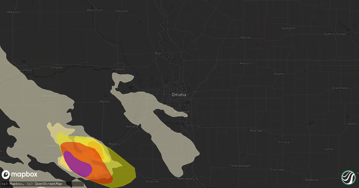
Hail Map in Omaha, NE on June 16, 2017
Get this storm
June 16 map
$229
one time, instant access
Download today. No call, no setup
Keep the $229
Bought the map and want the full workflow? Apply the entire $229 to a subscription within 7 days. None of it is wasted.
Every map, not just this one
This buys you this map. Subscription and you get every map we run, in the markets you choose from a few cities to whole states to nationwide. Plus real-time alerts the moment a storm fires.
Contact data
Name, contact info, occupancy, even credit band for addresses in the footprint. You go from where it hit to who to call.
Become the source they trust
Unlimited branding weather history reports on demand. You already have the documented answer ready for the property owner, and you are the one who showed up with it.
Property data and RoofTrace estimates
Pull up any address you have got, its value and the exact code rules for that jurisdiction, straight from One Click Code. Then RoofTrace estimates the squares, pitch, and roof value, priced the way you price.
Storm reports in Omaha, NE
Omaha, NE
| Date | Description |
|---|---|
| 06/15/20178:04 PM CDT | At omaha airport. |
| 06/15/20177:59 PM CDT | 132nd and cornhusker |
| 06/15/20177:55 PM CDT | 132nd and harrison area. Big trees down along with several fences in the neighbood. |
| 06/15/20177:50 PM CDT | Trees down. |
| 06/15/20177:48 PM CDT | A local report indicates 85 MPH wind near 3 NNE GRETNA |
| 06/15/20177:35 PM CDT | 173rd and f. Numerous trees down and transformers |
All States Impacted by Hail Map on June 16, 2017
All Cities Impacted by Hail Map on June 16, 2017
- Mount Ayr, IA
- Kellerton, IA
- Monroe, NE
- Platte Center, NE
- Washington, KS
- Morrowville, KS
- Brandon, MS
- Pearl, MS
- Flowood, MS
- Melvern, KS
- Burlingame, KS
- Osage City, KS
- Scranton, KS
- Vassar, KS
- Lebo, KS
- Lyndon, KS
- Lambert, MS
- Vance, MS
- Stewartville, MN
- Silas, AL
- Bolckow, MO
- Savannah, MO
- Rea, MO
- Rosendale, MO
- West Point, NE
- Wisner, NE
- Beemer, NE
- Marvell, AR
- Louisville, MS
- Pomona, KS
- Alden, IA
- Grove Hill, AL
- Mount Horeb, WI
- Verona, WI
- Morton, MS
- Pulaski, MS
- Aurora, NE
- Hampton, NE
- Jackson, MS
- La Cygne, KS
- Parker, KS
- Centerville, KS
- Osawatomie, KS
- Fontana, KS
- Pleasanton, KS
- Mound City, KS
- Florence, MS
- Braxton, MS
- Gresham, WI
- Fairbury, NE
- Waco, NE
- Dorchester, NE
- Frankfort, KS
- Marysville, KS
- Pickrell, NE
- McCool Junction, NE
- Home, KS
- Milford, NE
- Cordova, NE
- Barneston, NE
- Cortland, NE
- Wymore, NE
- Friend, NE
- Clatonia, NE
- Crete, NE
- York, NE
- Wilber, NE
- Filley, NE
- Oketo, KS
- Exeter, NE
- Western, NE
- Liberty, NE
- Beattie, KS
- Virginia, NE
- Beatrice, NE
- Hallam, NE
- Tobias, NE
- De Witt, NE
- Blue Springs, NE
- Bremen, KS
- Milligan, NE
- Beaver Crossing, NE
- Bay Springs, MS
- West Portsmouth, OH
- Stout, OH
- Saint Joseph, MO
- Faucett, MO
- Agency, MO
- Cameron, NC
- Carthage, NC
- Randolph, KS
- Leonardville, KS
- Waterloo, NE
- Yutan, NE
- Itta Bena, MS
- Sidon, MS
- Baldwin City, KS
- Otterbein, IN
- Shawano, WI
- Lanesboro, MN
- Utica, MN
- Fountain, MN
- Chatfield, MN
- Worden, IL
- Edwardsville, IL
- Cochrane, WI
- Arcadia, WI
- Independence, WI
- Alma, WI
- Greenville, MS
- Macon, MS
- Bern, KS
- Sabetha, KS
- Morrill, KS
- Salem, NE
- Oneida, KS
- Dawson, NE
- Rudolph, WI
- Wisconsin Rapids, WI
- Burlington Junction, MO
- Skidmore, MO
- Raleigh, MS
- Fairchild, WI
- Blair, WI
- Willard, WI
- Humbird, WI
- Strum, WI
- Osseo, WI
- Fountain City, WI
- Whitehall, WI
- Alma Center, WI
- Clemons, IA
- State Center, IA
- McCallsburg, IA
- Saint Anthony, IA
- Zearing, IA
- Radcliffe, IA
- Nemaha, NE
- Huntington, IN
- North Manchester, IN
- Mize, MS
- Mount Olive, MS
- Magee, MS
- Caruthersville, MO
- Fairview, MI
- Curran, MI
- Bellwood, NE
- Genoa, NE
- Columbus, NE
- Silver Creek, NE
- Saint Edward, NE
- Lindsay, NE
- Humphrey, NE
- Mahaska, KS
- Daykin, NE
- Reynolds, NE
- Hanover, KS
- Greenleaf, KS
- Alexandria, NE
- Steuben, WI
- Eastman, WI
- Greenfield, MO
- Everton, MO
- Lane, KS
- Rossville, KS
- Viroqua, WI
- Imogene, IA
- Leland, MS
- Manson, IA
- Somers, IA
- Moorland, IA
- Staplehurst, NE
- Utica, NE
- Seward, NE
- Luxora, AR
- Galena, KS
- Columbus, KS
- Jolley, IA
- Pomeroy, IA
- Fonda, IA
- Strang, NE
- McCune, KS
- Coahoma, MS
- Lyon, MS
- Marks, MS
- Harveyville, KS
- Colony, KS
- Mindenmines, MO
- Westphalia, KS
- Iola, KS
- Paxico, KS
- Elsmore, KS
- Stark, KS
- Girard, KS
- Opolis, KS
- Belvue, KS
- Wakarusa, KS
- Webb City, MO
- Asbury, MO
- Quenemo, KS
- Williamsburg, KS
- Carbondale, KS
- Kincaid, KS
- Welda, KS
- Uniontown, KS
- Eskridge, KS
- Baxter Springs, KS
- Richmond, KS
- Hepler, KS
- Saint Paul, KS
- Garnett, KS
- La Harpe, KS
- Erie, KS
- Walnut, KS
- Waverly, KS
- Scammon, KS
- Oronogo, MO
- Cherokee, KS
- Pittsburg, KS
- Wamego, KS
- Joplin, MO
- Carl Junction, MO
- Topeka, KS
- Savonburg, KS
- Moran, KS
- Auburn, KS
- Riverton, KS
- Saint Marys, KS
- Maple Hill, KS
- Weir, KS
- Frontenac, KS
- Stanton, NE
- Pilger, NE
- Holly Grove, AR
- Spring Valley, MN
- Winona, MN
- Greentop, MO
- Maitland, MO
- Madison, MS
- Canton, MS
- Wabasha, MN
- Kellogg, MN
- Altura, MN
- Emmett, KS
- Soldier, KS
- Mayetta, KS
- Delia, KS
- Tunica, MS
- Marianna, AR
- West Lafayette, IN
- West Helena, AR
- Lexa, AR
- Gunnison, MS
- Shelby, MS
- Stromsburg, NE
- Osceola, NE
- Shelby, NE
- Gresham, NE
- Bruning, NE
- Barnes, KS
- Linn, KS
- Waterville, KS
- Blue Rapids, KS
- Hubbell, NE
- Hebron, NE
- Jansen, NE
- Diller, NE
- Steele City, NE
- Olsburg, KS
- Gilead, NE
- Ohiowa, NE
- Hollenberg, KS
- Onaga, KS
- Westmoreland, KS
- Endicott, NE
- Fairmont, NE
- Geneva, NE
- Clintonville, WI
- Shiocton, WI
- Bonduel, WI
- Pierce, NE
- Winside, NE
- Randolph, NE
- Carroll, NE
- Hoskins, NE
- Ossineke, MI
- Sidney, IA
- Farragut, IA
- Riverton, IA
- Tarkio, MO
- Rougemont, NC
- Oxford, NC
- Roxboro, NC
- Timberlake, NC
- Farmersville, IL
- North Bend, NE
- Schuyler, NE
- Clarkson, NE
- Coffeeville, MS
- Minnesota City, MN
- Plainview, MN
- Houston, MS
- Battle Creek, NE
- Madison, NE
- Neligh, NE
- Brunswick, NE
- Plainview, NE
- Royal, NE
- Leigh, NE
- Tilden, NE
- Orchard, NE
- Meadow Grove, NE
- Norfolk, NE
- Dayton, IA
- Lehigh, IA
- Malcolm, NE
- Pleasant Dale, NE
- Raymond, NE
- Martell, NE
- Denton, NE
- Roca, NE
- Davey, NE
- Lincoln, NE
- Rollingstone, MN
- Saint Charles, MN
- Eupora, MS
- Somerville, TN
- Oregon, WI
- Brooklyn, WI
- Belleville, WI
- Barton City, MI
- South Branch, MI
- Malabar, FL
- Palm Bay, FL
- Chatom, AL
- Millry, AL
- Lexington, MS
- Cruger, MS
- Buffalo Center, IA
- Theodore, AL
- Vandalia, IL
- Ramsey, IL
- Newman Grove, NE
- Meridian, MS
- Wagarville, AL
- Goff, KS
- Green Sea, SC
- Cross Plains, WI
- Coila, MS
- Greenwood, MS
- La Grange, TN
- Truman, MN
- Trimont, MN
- Chetopa, KS
- Havensville, KS
- Hoyt, KS
- Silver Lake, KS
- Durant, MS
- Tchula, MS
- Belzoni, MS
- Robinsonville, MS
- Brickeys, AR
- Hughes, AR
- Falls City, NE
- Calhoun City, MS
- Morse Bluff, NE
- Blytheville, AR
- Beulah, MS
- Benoit, MS
- Arkansas City, AR
- Rohwer, AR
- Watson, AR
- Dermott, AR
- State Line, MS
- Buckatunna, MS
- Dodge, NE
- Waynesboro, MS
- Starkville, MS
- Sturgis, MS
- Villisca, IA
- Elliott, IA
- Kingman, IN
- Covington, IN
- Veedersburg, IN
- Portland, AR
- Hamburg, AR
- Parkdale, AR
- Amboy, MN
- Welcome, MN
- Fairmont, MN
- Stoughton, WI
- Garland, NE
- Water Valley, MS
- Belgrade, MO
- Boscobel, WI
- Collins, IA
- Maxwell, IA
- Corning, IA
- New Century, KS
- Lawrence, KS
- Overbrook, KS
- Princeton, KS
- Brainard, NE
- Berryton, KS
- Bee, NE
- Gardner, KS
- Ozawkie, KS
- Bronson, KS
- West Mineral, KS
- Ottawa, KS
- Eudora, KS
- Duncan, NE
- Saint George, KS
- Dwight, NE
- Bennet, NE
- Arma, KS
- De Soto, KS
- Clarks, NE
- Plymouth, NE
- Walton, NE
- Green, KS
- Meriden, KS
- Franklin, KS
- Elgin, NE
- Tonganoxie, KS
- Petersburg, NE
- Valparaiso, NE
- Odell, NE
- Goehner, NE
- Alma, KS
- Lecompton, KS
- Vermillion, KS
- Surprise, NE
- Tecumseh, KS
- Albion, NE
- Bruno, NE
- Manhattan, KS
- David City, NE
- Rising City, NE
- Fullerton, NE
- Perry, KS
- Weston, NE
- Grantville, KS
- Ulysses, NE
- Oakdale, NE
- Linwood, KS
- Olathe, KS
- Casco, WI
- Luxemburg, WI
- Algoma, WI
- Badger, IA
- Baring, MO
- Amazonia, MO
- Cosby, MO
- Easton, MO
- Murray, NE
- Sarah, MS
- Clarksdale, MS
- Forrest City, AR
- Helena, AR
- Dundee, MS
- Sledge, MS
- Crenshaw, MS
- Preston, MN
- Wykoff, MN
- Peterson, MN
- Philadelphia, MS
- Easton, MN
- Delavan, MN
- Birnamwood, WI
- Grand Island, NE
- Blue River, WI
- Kanawha, IA
- Clinton, MO
- Urich, MO
- Montrose, MO
- Boyle, MS
- Shaw, MS
- Doddsville, MS
- Cleveland, MS
- Ridgeland, MS
- Scheller, IL
- La Belle, MO
- Randolph, MS
- Banner, MS
- Cecil, WI
- Helena, MO
- Union Star, MO
- White Hall, IL
- Proctor, AR
- Heth, AR
- Cape Girardeau, MO
- Marquette, NE
- Essex, IA
- Shenandoah, IA
- Salem, WI
- Greenwood, NE
- Ashland, NE
- Wahoo, NE
- Ceresco, NE
- Thomasville, AL
- Lachine, MI
- Herron, MI
- Alpena, MI
- Hillman, MI
- Tillatoba, MS
- Charleston, MS
- Coldwater, MS
- Crawfordsville, AR
- Black River, MI
- Waldo, WI
- Random Lake, WI
- Leroy, AL
- Millington, TN
- Blue Earth, MN
- Rantoul, KS
- Edgerton, KS
- Paola, KS
- Wellsville, KS
- Allegan, MI
- De Soto, WI
- Madrid, IA
- Osage, IA
- Petal, MS
- Blue Mounds, WI
- Brooksville, MS
- Crawford, MS
- Muscoda, WI
- Wauzeka, WI
- Gays Mills, WI
- Platteville, WI
- Eldora, IA
- Steamboat Rock, IA
- Iowa Falls, IA
- Widener, AR
- Bloomingdale, IN
- Mount Hope, WI
- Lockwood, MO
- Tutwiler, MS
- Sherburn, MN
- Comins, MI
- Chunky, MS
- Spavinaw, OK
- Britt, IA
- Duncombe, IA
- Otho, IA
- Stratford, IA
- Fort Dodge, IA
- Caledonia, MI
- Woden, IA
- Thompson, IA
- Columbia, NC
- Loyal, WI
- Ferryville, WI
- Ames, NE
- Louin, MS
- Lake Mills, IA
- Joice, IA
- Elberon, VA
- Ivor, VA
- Smithfield, VA
- Surry, VA
- Livingston, WI
- Belmont, WI
- Lancaster, WI
- Rogers, NE
- Shelby, IA
- Harlan, IA
- Rosedale, MS
- Randolph, IA
- Lucedale, MS
- McLain, MS
- Camden, SC
- Bishopville, SC
- Barneveld, WI
- Chaseburg, WI
- Westby, WI
- Nehawka, NE
- Collinsville, MS
- Union, MS
- Ethel, MS
- McCool, MS
- Sardis, MS
- Como, MS
- Indianola, MS
- Yazoo City, MS
- Stephenson, MI
- Springfield, NE
- Gretna, NE
- Bristol, WI
- Story City, IA
- Mound Bayou, MS
- Saint Louis, MO
- Oakwood, IL
- Shuqualak, MS
- Mayersville, MS
- Rochester, MN
- Eyota, MN
- Elaine, AR
- Chilhowee, MO
- Blairstown, MO
- Carrollton, MS
- Shubert, NE
- New Providence, IA
- Ellsworth, IA
- Hubbard, IA
- Ceylon, MN
- Rocky Mount, NC
- Moselle, MS
- Ovett, MS
- Ellisville, MS
- Marshalltown, IA
- Welch, OK
- Emerson, NE
- Pattonsburg, MO
- Green Bay, WI
- New Franken, WI
- Forestville, WI
- Brussels, WI
- Winona, MS
- Duck Hill, MS
- McCarley, MS
- Newton, MS
- Lawrence, MS
- Eudora, AR
- Hollandale, MS
- Peru, NE
- Nebraska City, NE
- Mobile, AL
- Lake, MS
- Schlater, MS
- Sunflower, MS
- Cedarbluff, MS
- Pheba, MS
- Polk City, IA
- Roland, IA
- Lake Providence, LA
- Pacific Junction, IA
- Glenwood, IA
- Carmi, IL
- Crossville, IL
- Fairview, KS
- Scribner, NE
- Leland, IA
- Shubuta, MS
- Irondale, MO
- Caledonia, MO
- De Kalb, MS
- Scooba, MS
- Steele, MO
- Fort Scott, KS
- Winnetoon, NE
- Creighton, NE
- Everest, KS
- Denton, KS
- Cummings, KS
- Atchison, KS
- Lancaster, KS
- Sheridan, MO
- Pickering, MO
- Hopkins, MO
- Parnell, MO
- Ravenwood, MO
- Gentry, MO
- Stanberry, MO
- Quitman, MS
- Elizabeth City, NC
- South Mills, NC
- Prescott, IA
- Urbana, IN
- South Whitley, IN
- Wilmer, AL
- Cumberland, IA
- Griswold, IA
- Fowler, IN
- Bahama, NC
- Nortonville, KS
- Pollock, MO
- Unionville, MO
- Lucerne, MO
- Henderson, NE
- Cedar Creek, NE
- Louisville, NE
- Rhodes, IA
- Baxter, IA
- Walnut, IA
- Hancock, IA
- Avoca, IA
- Oakland, IA
- Lewis, IA
- Coon Valley, WI
- Thurston, NE
- Taylorsville, MS
- Circleville, KS
- Corning, KS
- Holton, KS
- Waverly, NE
- Vernon Center, MN
- Granada, MN
- Satartia, MS
- Douglas, NE
- Adams, NE
- Merrillan, WI
- Dover, MN
- Vossburg, MS
- Heidelberg, MS
- Clarinda, IA
- New Market, IA
- Madison, WI
- Middleton, WI
- Collins, MS
- Lillington, NC
- Daggett, MI
- Hubbard Lake, MI
- Krakow, WI
- Pulaski, WI
- Hickory, MS
- Decatur, MS
- Prescott, KS
- Mapleton, KS
- Fulton, KS
- Richards, MO
- Hume, MO
- Greeley, KS
- Stewart, MS
- Stilwell, KS
- Rolling Fork, MS
- Isola, MS
- Lansing, KS
- Leavenworth, KS
- Jackson, MO
- Altenburg, MO
- Bowler, WI
- Hopkinton, IA
- Ryan, IA
- Hertford, NC
- Covington, TN
- Holden, MO
- Nodaway, IA
- Verdon, NE
- Rock Port, MO
- Julian, NE
- Fairfax, MO
- Watson, MO
- Stella, NE
- Auburn, NE
- Brock, NE
- Westboro, MO
- Brownville, NE
- Union, NE
- Plattsmouth, NE
- Edina, MO
- Whatley, AL
- Lake Worth, FL
- West Palm Beach, FL
- Oakland, MS
- Richton, MS
- Linwood, NE
- Bartlett, KS
- Knox City, MO
- Osceola, AR
- Little Rock, MS
- McLouth, KS
- Winchester, KS
- Easton, KS
- Cedar Falls, IA
- Afton, OK
- Vinita, OK
- Salisbury, NC
- Mocksville, NC
- Lakota, IA
- Decorah, IA
- Dorchester, IA
- Gallatin, MO
- Jameson, MO
- Kilmichael, MS
- Inverness, MS
- Lake Village, AR
- Titonka, IA
- Alpha, MN
- Spirit Lake, IA
- Jackson, MN
- Estherville, IA
- Hickory Valley, TN
- Whiteville, TN
- Ames, IA
- Palmyra, NE
- Eagle, NE
- Bluffton, IN
- Wayne, NE
- Osmond, NE
- Nickerson, NE
- Fremont, NE
- Hooper, NE
- Denver, MO
- Lena, MS
- Giltner, NE
- Pembine, WI
- Wakefield, NE
- Earle, AR
- Novinger, MO
- Kirksville, MO
- Mikado, MI
- Glennie, MI
- Marion, WI
- Pelahatchie, MS
- Hiawatha, KS
- Horton, KS
- Rushford, MN
- Mound City, MO
- Craig, MO
- Dakota, MN
- Arlington, NE
- Gravity, IA
- Bedford, IA
- Melbourne, IA
- Haverhill, IA
- Union, IA
- Colo, IA
- Albion, IA
- Jewell, IA
- Ripley, TN
- Minden, IA
- Neola, IA
- Neillsville, WI
- Woodward, IA
- Ackerman, MS
- Kosciusko, MS
- Carthage, MS
- Malvern, IA
- Unity, WI
- Spencer, WI
- Greenwood, WI
- Conway, NC
- Troy, TN
- Northwood, IA
- Scarville, IA
- Woodbine, IA
- Pisgah, IA
- Unadilla, NE
- Guilford, MO
- Darlington, MO
- Albany, MO
- Union City, TN
- Denison, KS
- Valley Falls, KS
- Lenox, IA
- Zebulon, NC
- Middlesex, NC
- Logan, IA
- Portsmouth, IA
- Persia, IA
- Emerson, IA
- Hastings, IA
- Oaktown, IN
- Hixton, WI
- Bradshaw, NE
- Burlington, WI
- Champaign, IL
- Walls, MS
- Wolcott, IN
- Brookston, IN
- Remington, IN
- Flora, MS
- Dunnell, MN
- Monroeville, AL
- Lathrop, MO
- South Haven, MI
- Aurora, NC
- Rulo, NE
- Batesville, MS
- Bailey, MS
- Quapaw, OK
- Picher, OK
- Byron Center, MI
- Dorr, MI
- Wayland, MI
- Dyer, TN
- Sturgeon Bay, WI
- Stoddard, WI
- Genoa, WI
- Wetmore, KS
- Powhattan, KS
- Carlisle, IN
- Hopkins, MI
- Otsego, MI
- Martin, MI
- Kansas City, MO
- Kansas City, KS
- Vardaman, MS
- Swanton, NE
- Baileys Harbor, WI
- Keshena, WI
- Effingham, KS
- West Olive, MI
- Lake Cormorant, MS
- Troy, KS
- Conception Junction, MO
- Conception, MO
- Clyde, MO
- Houlka, MS
- Marshall, IN
- Deerfield, MO
- Nevada, MO
- Moundville, MO
- Clinton, MS
- Sainte Genevieve, MO
- Ettrick, WI
- Galesville, WI
- Trempealeau, WI
- Dodge, WI
- Stanhope, IA
- Mississippi State, MS
- Seneca, KS
- Charles City, IA
- Racine, MN
- Oblong, IL
- Sumner, IL
- Blue Mound, KS
- Moorhead, MS
- Weeping Water, NE
- Finleyville, PA
- Clairton, PA
- Onawa, IA
- Blencoe, IA
- Elkhorn, NE
- Avoca, NE
- Colon, NE
- La Vista, NE
- South Bend, NE
- Percival, IA
- Offutt Afb, NE
- Manley, NE
- Papillion, NE
- Omaha, NE
- Dunbar, NE
- Bellevue, NE
- Murdock, NE
- Valley, NE
- Mead, NE
- Thurman, IA
- Otoe, NE
- Fuquay Varina, NC
- Brownsville, TN
- Valley Park, MS
- Bruce, MS
- Lees Summit, MO
- Walthill, NE
- Pender, NE
- Winnebago, NE
- Cook, NE
- Mantee, MS
- Hickman, KY
- Albert Lea, MN
- Glenville, MN
- Hayward, MN
- Kansasville, WI
- Jerico Springs, MO
- Arcola, MO
- Gore Springs, MS
- Delhi, IA
- Sweet Water, AL
- Merigold, MS
- Davis City, IA
- Blythedale, MO
- Bennington, NE
- Kennard, NE
- Eight Mile, AL
- Apex, NC
- Holly Springs, NC
- Renwick, IA
- Belleview, MO
- Oxford, MS
- Holland, MI
- Bellefontaine, MS
- Forest City, IA
- Oxford, NE
- Edison, NE
- Howells, NE
- Cedar Bluffs, NE
- Prague, NE
- Malmo, NE
- Page, NE
- Creston, NE
- Clearwater, NE
- Toxey, AL
- Gilbertown, AL
- Spring Lake, NC
- Export, PA
- Clearmont, MO
- Yorktown, IA
- Coin, IA
- College Springs, IA
- Blanchard, IA
- Braddyville, IA
- Elmo, MO
- Mclean, NE
- Benton, MS
- Dendron, VA
- Williamsburg, VA
- Windsor, VA
- Spring Grove, VA
- Elmore, MN
- Redwood, MS
- Butler, AL
- Council Bluffs, IA
- Syracuse, NE
- Burr, NE
- Fillmore, MO
- Oregon, MO
- Luther, IA
- Boone, IA
- Black River Falls, WI
- Frankville, AL
- Robinson, KS
- Willow Hill, IL
- Fort Stockton, TX
- Emelle, AL
- Tabor, IA
- Sheldon, MO
- Milo, MO
- Lamar, MO
- Atlanta, MI
- Blue Springs, MO
- Red Oak, IA
- Needham, AL
- Oostburg, WI
- Decatur, NE
- Macy, NE
- Woodland, MS
- Rosalie, NE
- Augusta, MO
- Marthasville, MO
- Roper, NC
- Augusta, WI
- Colby, WI
- Jackson, AL
- Ahoskie, NC
- Polo, MO
- Lawson, MO
- Grayville, IL
- Shelbina, MO
- Lamoni, IA
- Palmer, IA
- Orchard, IA
- Saint Ansgar, IA
- Carpenter, IA
- Lumberton, MS
- Chesapeake, VA
- Milford, IL
- Van Wert, OH
- Bluejacket, OK
- King City, MO
- Hernando, MS
- Willow Spring, NC
- Angier, NC
- Webster City, IA
- Arapahoe, NE
- Phillips, NE
- Burchard, NE
- Hickman, NE
- Haddam, KS
- Belvidere, NE
- Spring Hill, KS


