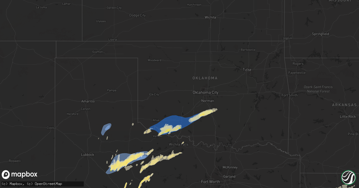
Hail Map in Oklahoma on April 9, 2024
Get this storm
April 9 map
$229
one time, instant access
Download today. No call, no setup
Keep the $229
Bought the map and want the full workflow? Apply the entire $229 to a subscription within 7 days. None of it is wasted.
Every map, not just this one
This buys you this map. Subscription and you get every map we run, in the markets you choose from a few cities to whole states to nationwide. Plus real-time alerts the moment a storm fires.
Contact data
Name, contact info, occupancy, even credit band for addresses in the footprint. You go from where it hit to who to call.
Become the source they trust
Unlimited branding weather history reports on demand. You already have the documented answer ready for the property owner, and you are the one who showed up with it.
Property data and RoofTrace estimates
Pull up any address you have got, its value and the exact code rules for that jurisdiction, straight from One Click Code. Then RoofTrace estimates the squares, pitch, and roof value, priced the way you price.
Storm reports in Oklahoma
Oklahoma
| Date | Description |
|---|---|
| 04/08/202411:23 PM CDT | Location estimated from radar. |
| 04/08/20249:46 PM CDT | Power outages reported near intersection of highway 36 and highway 5. |
| 04/08/20249:30 PM CDT | Estimated by storm spotter. |
| 04/08/20249:28 PM CDT | A local report indicates 1.25 inch wind near 3 S Hollister |
| 04/08/20249:21 PM CDT | A local report indicates 58 MPH wind near 3 SE Davidson |
| 04/08/20249:15 PM CDT | Power pole downed... Time estimate from radar. |
| 04/08/20249:10 PM CDT | A local report indicates 1.00 inch wind near Davidson |
All States Impacted by Hail Map on April 9, 2024
Cities Impacted by Hail Map on April 9, 2024
- Snyder, TX
- Justiceburg, TX
- Girard, TX
- Frankston, TX
- Palestine, TX
- Jayton, TX
- Spur, TX
- Aspermont, TX
- Dickens, TX
- Stonewall, LA
- Frierson, LA
- Shreveport, LA
- Old Glory, TX
- Paducah, TX
- Elgin, TX
- Austin, TX
- Roscoe, TX
- Seymour, TX
- Thrall, TX
- Sweetwater, TX
- Thorndale, TX
- Lexington, TX
- Buckholts, TX
- Cameron, TX
- Davilla, TX
- Rockdale, TX
- Hutto, TX
- Taylor, TX
- Georgetown, TX
- Round Rock, TX
- Pflugerville, TX
- Roby, TX
- Granger, TX
- Merkel, TX
- Benjamin, TX
- Munday, TX
- Knox City, TX
- Lott, TX
- Jarrell, TX
- Bartlett, TX
- Salado, TX
- Anson, TX
- Rule, TX
- Stamford, TX
- Sylvester, TX
- Hawley, TX
- Rochester, TX
- Belton, TX
- Lampasas, TX
- Burnet, TX
- Chilton, TX
- Eddy, TX
- Moody, TX
- Troy, TX
- Temple, TX
- Haskell, TX
- Llano, TX
- Lorena, TX
- O'Brien, TX
- McCaulley, TX
- Weinert, TX
- McGregor, TX
- Abilene, TX
- Avoca, TX
- Kingsland, TX
- Mount Calm, TX
- Axtell, TX
- Lueders, TX
- Goree, TX
- Marble Falls, TX
- Throckmorton, TX
- Riesel, TX
- Killeen, TX
- Mart, TX
- Albany, TX
- Harker Heights, TX
- Lockney, TX
- Trinidad, TX
- Kerens, TX
- Malakoff, TX
- Corsicana, TX
- Bertram, TX
- Athens, TX
- Bruceville, TX
- Woodway, TX
- Maryneal, TX
- Robert Lee, TX
- Mabank, TX
- Eustace, TX
- Blackwell, TX
- Olney, TX
- Holliday, TX
- Wichita Falls, TX
- Lometa, TX
- Windthorst, TX
- Archer City, TX
- Scotland, TX
- Silverton, TX
- Quitaque, TX
- Clarendon, TX
- Gatesville, TX
- Evant, TX
- Henrietta, TX
- Floydada, TX
- Hamilton, TX
- Purmela, TX
- Jonesboro, TX
- Laneville, TX
- Mount Enterprise, TX
- Henderson, TX
- Long Branch, TX
- Carthage, TX
- Gary, TX
- Garrison, TX
- Timpson, TX
- Beckville, TX
- Keatchie, LA
- Grand Cane, LA
- Logansport, LA
- Gloster, LA
- Mansfield, LA
- Brady, TX
- Elm Grove, LA
- Bossier City, LA
- Shelbyville, TX
- Mason, TX
- Voca, TX
- Converse, LA
- Ringgold, LA
- Fredonia, TX
- San Saba, TX
- Pleasant Hill, LA
- Pelican, LA
- Heflin, LA
- Manor, TX
- Pontotoc, TX
- Cherokee, TX
- Bienville, LA
- Coushatta, LA
- Marthaville, LA
- Jamestown, LA
- Castor, LA
- Valley Spring, TX
- Saline, LA
- Campti, LA
- Simsboro, LA
- Arcadia, LA
- Ruston, LA
- Quitman, LA
- Art, TX
- Goldonna, LA
- Choudrant, LA
- Grambling, LA
- Tow, TX
- Calhoun, LA
- Downsville, LA
- Coupland, TX
- Eros, LA
- West Monroe, LA
- Dodson, LA
- Dripping Springs, TX
- Bluffton, TX
- Monroe, LA
- Rayville, LA
- Sikes, LA
- Fredericksburg, TX
- Olla, LA
- Oak Ridge, LA
- Columbia, LA
- Doss, TX
- Grayson, LA
- Kempner, TX
- Briggs, TX
- Woodville, TX
- Kelly, LA
- Round Mountain, TX
- Spicewood, TX
- Willow City, TX
- Leander, TX
- Nacogdoches, TX
- Colmesneil, TX
- Childress, TX
- Robeline, LA
- Doyline, LA
- Florence, TX
- Vicksburg, MS
- Sterlington, LA
- Horseshoe Bay, TX
- Jasper, TX
- Valley Park, MS
- Livingston, TX
- Liberty, TX
- Redwood, MS
- Tallulah, LA
- Johnson City, TX
- Liberty Hill, TX
- Warren, TX
- Hye, TX
- Cleveland, TX
- Broaddus, TX
- Bolton, MS
- Edwards, MS
- Quanah, TX
- Chester, TX
- Satartia, MS
- Bronson, TX
- Pineland, TX
- Cedar Park, TX
- Raymond, MS
- Flora, MS
- Bentonia, MS
- Chillicothe, TX
- Holland, TX
- Blanco, TX
- Boerne, TX
- Saratoga, TX
- Rogers, TX
- Little River Academy, TX
- Jackson, MS
- Madison, MS
- Clinton, MS
- Kendalia, TX
- Hull, TX
- Ridgeland, MS
- Yazoo City, MS
- Driftwood, TX
- Florien, LA
- Manchaca, TX
- Buda, TX
- Fred, TX
- Hillister, TX
- Canton, MS
- Kountze, TX
- Belmont, LA
- Batson, TX
- Tougaloo, MS
- Brandon, MS
- Davidson, OK
- Frederick, OK
- Elmer, OK
- Vernon, TX
- Odell, TX
- Tipton, OK
- Eldorado, OK
- Del Valle, TX
- Olustee, OK
- Wimberley, TX
- Pearl, MS
- Flowood, MS
- Burlington, TX
- Hondo, TX
- D Hanis, TX
- Haughton, LA
- Headrick, OK
- Altus, OK
- Hollister, OK
- Cedar Creek, TX
- Bergheim, TX
- Spring Branch, TX
- Bulverde, TX
- Sabinal, TX
- Pelahatchie, MS
- Lena, MS
- Rosebud, TX
- Bastrop, TX
- Harrold, TX
- Loveland, OK
- Grandfield, OK
- Snyder, OK
- Morton, MS
- Chattanooga, OK
- Walters, OK
- Mountain Park, OK
- Indiahoma, OK
- Batesville, TX
- Spurger, TX
- Castroville, TX
- Paige, TX
- Devol, OK
- Forest, MS
- Smithville, TX
- Carthage, MS
- Faxon, OK
- Cache, OK
- Canyon Lake, TX
- Florence, MS
- Rio Medina, TX
- Mico, TX
- San Antonio, TX
- Helotes, TX
- Braxton, MS
- McDade, TX
- Big Wells, TX
- Asherton, TX
- Carrizo Springs, TX
- Laredo, TX
- Yancey, TX
- Lawton, OK
- Geronimo, OK
- Encinal, TX
- Walnut Grove, MS
- Philadelphia, MS
- Union, MS
- Sebastopol, MS
- Cotulla, TX
- Catarina, TX
- Kirbyville, TX
- Call, TX
- Devine, TX
- Conehatta, MS
- Fort Sill, OK
- Medicine Park, OK
- Moore, TX
- Bon Wier, TX
- Bremond, TX
- Jbsa Lackland, TX
- La Coste, TX
- Reagan, TX
- Newton, TX
- Pearsall, TX
- Pulaski, MS
- Caldwell, TX
- Dime Box, TX
- Elgin, OK
- Marlow, OK
- Rush Springs, OK
- Duncan, OK
- Fletcher, OK
- Marlin, TX
- Natalia, TX
- Poteet, TX
- Lytle, TX
- Merryville, LA
- Lincoln, TX
- Crystal City, TX
- Somerville, TX
- Lake, MS
- Moscow, TX
- Corrigan, TX
- Converse, TX
- Somerset, TX
- Kosse, TX
- Burkeville, TX
- Adkins, TX
- Lawrence, MS
- Jbsa Ft Sam Houston, TX
- Von Ormy, TX
- Schertz, TX
- Universal City, TX
- Jbsa Randolph, TX
- Saint Hedwig, TX
- Cibolo, TX
- Seguin, TX
- Marion, TX
- New Braunfels, TX
- McQueeney, TX
- Bradley, OK
- Lindsay, OK
- Franklin, TX
- Decatur, MS
- Dilley, TX
- La Vernia, TX
- Thornton, TX
- Evans, LA
- Deridder, LA
- Lyons, TX
- Kingsbury, TX
- Fowlerton, TX
- Snook, TX
- Pleasanton, TX
- Elmendorf, TX
- Floresville, TX
- Jewett, TX
- Marquez, TX
- Charlotte, TX
- Diboll, TX
- Lufkin, TX
- Maysville, OK
- Wayne, OK
- Tilden, TX
- Pauls Valley, OK
- Giddings, TX
- Navasota, TX
- College Station, TX
- Jourdanton, TX
- Luling, TX
- Donie, TX
- Paoli, OK
- Leesville, TX
- Nixon, TX
- Purcell, OK
- Buffalo, TX
- Wanette, OK
- Byars, OK
- Lexington, OK
- Calliham, TX
- Gonzales, TX
- Cost, TX
- Whitsett, TX
- Three Rivers, TX
- Karnes City, TX
- Moulton, TX
- Leesville, LA
- Smiley, TX
- Westhoff, TX
- Hobson, TX
- Huntington, TX
- Zavalla, TX
- Cuero, TX
- New Llano, LA
- Flatonia, TX
- Schulenburg, TX
- Fort Polk, LA
- Weimar, TX
- Yoakum, TX
- East Bernard, TX
- La Grange, TX
- Edna, TX
- Louise, TX
- El Campo, TX
- Wallis, TX
- Fayetteville, TX
- Eagle Lake, TX
- Fulshear, TX
- Brookshire, TX
- Katy, TX
- Wharton, TX
- Mayersville, MS
- Sondheimer, LA
- Cypress, TX
- Newellton, LA
- Rolling Fork, MS
- Tomball, TX
- Copperas Cove, TX
- Houston, TX
- Onalaska, TX
- Crosby, TX
- Humble, TX
- Huffman, TX
- Ragley, LA
- Reeves, LA
- Kinder, LA
- Dry Creek, LA
- Napoleonville, LA
- Erath, LA
- Mittie, LA
- Oberlin, LA
- New Iberia, LA
- Delcambre, LA
- Pitkin, LA
- Youngsville, LA
- Abbeville, LA
- Broussard, LA
- Lafayette, LA
- Breaux Bridge, LA
- Saint Martinville, LA
- Crowley, LA
- Morse, LA
- Estherwood, LA
- Oakdale, LA
- Buna, TX
- Bandera, TX
- Rayne, LA
- Iota, LA
- Branch, LA
- Church Point, LA
- Egan, LA
- Eunice, LA
- Anahuac, TX
- Port Bolivar, TX
- Port Arthur, TX
- Winnie, TX
- Sabine Pass, TX
- Beaumont, TX
- Cameron, LA
- Groves, TX
- Bridge City, TX
- Vinton, LA
- Hackberry, LA
- Sulphur, LA
- Dequincy, LA
- Orange, TX
- Starks, LA
- Deweyville, TX
- Vidor, TX
- Port Neches, TX
- China, TX
- Lumberton, TX
- Nederland, TX
- Hamshire, TX
- Opelousas, LA
- Ville Platte, LA
- Lake Charles, LA
- Westlake, LA
- Grosse Tete, LA
- Maringouin, LA
- Bell City, LA
- Lacassine, LA
- Iowa, LA
- Jennings, LA
- Lake Arthur, LA
- Elton, LA
- Welsh, LA
- Rosedale, LA
- Washington, LA
- Richmond, TX
- Spring, TX
- Porter, TX
- Conroe, TX
- Damon, TX
- Rosharon, TX
- Alvin, TX
- Santa Fe, TX
- Dickinson, TX
- Texas City, TX
- La Marque, TX
- Bacliff, TX
- League City, TX
- Missouri City, TX
- Manvel, TX
- Pearland, TX
- Friendswood, TX
- Webster, TX
- Devers, TX
- Sour Lake, TX
- Silsbee, TX
- Nome, TX


