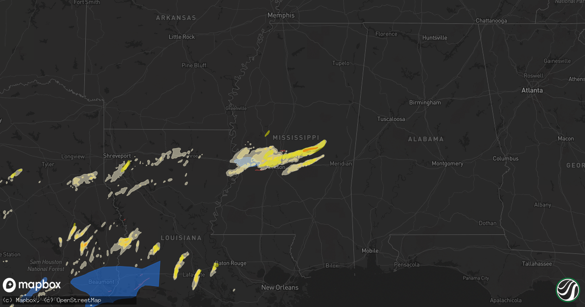
Hail Map on April 9, 2024
Get this storm
April 9 map
$229
one time, instant access
Download today. No call, no setup
Keep the $229
Bought the map and want the full workflow? Apply the entire $229 to a subscription within 7 days. None of it is wasted.
Every map, not just this one
This buys you this map. Subscription and you get every map we run, in the markets you choose from a few cities to whole states to nationwide. Plus real-time alerts the moment a storm fires.
Contact data
Name, contact info, occupancy, even credit band for addresses in the footprint. You go from where it hit to who to call.
Become the source they trust
Unlimited branding weather history reports on demand. You already have the documented answer ready for the property owner, and you are the one who showed up with it.
Property data and RoofTrace estimates
Pull up any address you have got, its value and the exact code rules for that jurisdiction, straight from One Click Code. Then RoofTrace estimates the squares, pitch, and roof value, priced the way you price.
States Impacted by Hail Map on April 9, 2024
Storm reports
Louisiana
| Date | Description |
|---|---|
| 04/09/20246:45 PM CDT | Trees and line down around rayville... Also on davis lake road. |
| 04/09/20246:38 PM CDT | Tree downed across us 425 south of mer rouge. |
| 04/09/20246:34 PM CDT | A few trees down on crew lake road and collins road. |
| 04/09/20246:28 PM CDT | Trees downed along la 139 between dewey brown rd and the parish line. |
| 04/09/20246:23 PM CDT | Kmlu metar measured a wind gust of 62 mph. |
| 04/09/20246:10 PM CDT | Trees down... Some snapped on the campus of the university of louisiana monroe. |
| 04/09/20246:00 PM CDT | Trees were downed across i-20 eastbound at mile marker 101 in calhoun... Forcing the closure of the interstate for a few hours. |
| 04/09/20245:30 PM CDT | Trees down blocking the 500 block of highway 479 near chestnut. |
| 04/09/20245:25 PM CDT | Trees were downed across the 500 block of highway 120 in marthaville. Numerous other trees were downed across multiple other locations across central and northern natch |
| 04/09/20245:00 PM CDT | Tree down on hwy 71 near coushatta. |
| 04/09/20244:41 PM CDT | Observed large branches down along us hwy 71 se of atkins... La. Measured a 64mph wind gust near mary magdalene cemetary along us 71. |
| 04/09/20244:30 PM CDT | Tree down on corner of poinsetta and crabapple. |
| 04/09/20246:54 AM CDT | Awos station kcwf chenault lk chas. |
| 04/09/20246:49 AM CDT | M |
| 04/09/20246:49 AM CDT | Mesonet stat |
| 04/09/20246:49 AM CDT | Mesonet station hakl1 sabine. |
| 04/09/20246:40 AM CDT | So reported tornado. |
| 04/09/20246:40 AM CDT | Possible tornado on ryan st. At library riot. |
| 04/09/20246:39 AM CDT | Nws employee reports multiple manufactured sheds blown into the road. |
| 04/09/20246:39 AM CDT | Trees snapped off. |
| 04/09/20246:38 AM CDT | An ef 2 tornado with max winds of 115 mph touched down near vernon road on the eastern side of mcneese state university and crossed common... Center... Harvard and kirk |
| 04/09/20246:37 AM CDT | Asos station klch lake charles. |
| 04/09/20246:31 AM CDT | The tornado touched down to the south of la-384 near honore lane... Damaging trees as it headed northeast toward the intracoastal waterway. The tornado continued throug |
| 04/09/20246:30 AM CDT | The tornado began near the intersection of herbert camp rd and big pasture road... Resulting in ef0-ef1 tree damage as it headed northeast. Surging winds to the south o |
| 04/09/20246:20 AM CDT | A large tree snapped and was completely blocking the road at this location. Photos received via facebook. |
| 04/09/20246:03 AM CDT | Report from mping: 1-inch tree limbs broken; shingles blown off. |
| 04/08/202411:30 PM CDT | Report of large trees down on hwy 464 ne of merryville. |
| 04/08/20248:53 PM CDT | Multiple trees and power lines down at kites marina. |
| 04/08/20247:23 PM CDT | Numerous trees down around town... Several power lines down. Gas station awning blown off. |
| 04/08/20247:00 PM CDT | Multiple trees downed in franklin parish. |
Mississippi
| Date | Description |
|---|---|
| 04/09/20244:39 AM CDT | Tree downed on a house in the ashbrooke subdivision. |
| 04/09/20244:39 AM CDT | Several trees down and some damage to homes around lake caroline and stribling rd. Possible tornado. |
| 04/09/20243:30 AM CDT | Multiple reports of trees downed on houses; bell island rd... Hanging moss rd... Sea island dr... Douglass rd... Hill dale dr... Etc... |
| 04/08/202411:00 PM CDT | Tree downed on roof. |
| 04/08/202410:55 PM CDT | Multiple trees downed on roads; hugh mitchell rd... Hoye pace rd... |
| 04/08/202410:42 PM CDT | *** 2 inj *** mobile homes rolled and damaged and trees down along johnson town rd. |
| 04/08/202410:30 PM CDT | A metal barn was collapsed in the good hope community. |
| 04/08/202410:20 PM CDT | Several trees downed in the dixon area... With trees downed on houses in the dixon community and the hope community. |
| 04/08/202410:05 PM CDT | Reports of multiple trees downed on roads; russsell community rd... Old hwy 80... Salem rd... Etc... |
| 04/08/202410:00 PM CDT | Quarter-sized hail was reported in lena... Ms. |
| 04/08/202410:00 PM CDT | Multiple trees downed on roads; sunnyside dr... Grand ave... Etc... |
| 04/08/20249:51 PM CDT | Dime to quarter size hail reported near the ludlow fire station. |
| 04/08/20249:40 PM CDT | Multiple trees down along hwy 483 between the ludlow fire station and first baptist church. |
| 04/08/20249:06 PM CDT | Trees and fences were downed in numerous locations within gluckstadt including clarkdell road and stout road. |
| 04/08/20249:03 PM CDT | Power line down blocking hwy 51. |
| 04/08/20249:02 PM CDT | Trees down on rice rd. |
| 04/08/20249:02 PM CDT | Hail up to the size of quarters fell in ridgeland. Report relayed via spotter network. |
| 04/08/20249:00 PM CDT | Multiple trees down and damage to a roof in the sheffield area of jackson. |
| 04/08/20248:59 PM CDT | A tree was blown down in the providence subdivision in gluckstadt. |
| 04/08/20248:56 PM CDT | Multiple trees down in madison on bozeman rd. |
| 04/08/20248:46 PM CDT | A local report indicates 1.00 inch wind near Pocahontas |
| 04/08/20248:41 PM CDT | Several trees down near hidden lake rd. |
| 04/08/20248:41 PM CDT | Quarter size hail reported. |
| 04/08/20248:38 PM CDT | Tree down on a car. |
| 04/08/20248:27 PM CDT | Trees and lines down on bill downing rd... Possible tornado. |
| 04/08/20248:23 PM CDT | Trees down. |
| 04/08/20248:22 PM CDT | Tree down on old port gibson rd. |
| 04/08/20248:16 PM CDT | Quarter size hail reported near eden. |
| 04/08/20247:55 PM CDT | Report of quarter sized hail. |
| 04/08/20247:53 PM CDT | Several trees down in the redwood and oak ridge areas. |
| 04/08/20247:52 PM CDT | Tree down across forest hill circle. |
| 04/08/20247:52 PM CDT | Numerous trees were blown down on multiple vehicles along interstate 20 east. Report relayed via spotter network. |
| 04/08/20247:50 PM CDT | Widespread downed trees and numerous power lines down in vicksburg. |
| 04/08/20247:42 PM CDT | Corrects previous tstm wnd dmg report from 10 nw kings. Multiple reports of trees downed on houses; bell island rd... Hanging moss rd... Sea island dr... Douglass rd... |
| 04/08/20247:40 PM CDT | Roof damage to a home on eagle lake. |
Oklahoma
| Date | Description |
|---|---|
| 04/08/202411:23 PM CDT | Location estimated from radar. |
| 04/08/20249:46 PM CDT | Power outages reported near intersection of highway 36 and highway 5. |
| 04/08/20249:30 PM CDT | Estimated by storm spotter. |
| 04/08/20249:28 PM CDT | A local report indicates 1.25 inch wind near 3 S Hollister |
| 04/08/20249:21 PM CDT | A local report indicates 58 MPH wind near 3 SE Davidson |
| 04/08/20249:15 PM CDT | Power pole downed... Time estimate from radar. |
| 04/08/20249:10 PM CDT | A local report indicates 1.00 inch wind near Davidson |
Texas
| Date | Description |
|---|---|
| 04/09/20246:52 PM CDT | Cocorahs observer reports hail ranging in size from pea to half dollar. Hail duration of 13 minutes. |
| 04/09/20246:46 PM CDT | Em gave report of golf ball size hail in this location. |
| 04/09/20246:43 PM CDT | Amateur radio report of 2 inch diameter hail in lake victor. |
| 04/09/20246:40 PM CDT | Delayed report: pictures and video of tennis ball size hail south of lampasas. Time estimated via radar. |
| 04/09/20246:38 PM CDT | Picture of softball size hail a quarter mile east of highway 281 in burnet county. Time estimated via radar. |
| 04/09/20246:35 PM CDT | Broadcast media relayed a photo from the public showing a measured hailstone with a diameter of 4 inches. Time estimated by radar. |
| 04/09/20246:25 PM CDT | A local report indicates 2.00 inch wind near Loyal Valley |
| 04/09/20246:20 PM CDT | Cocorahs observer reports hail ranging in size from 1.5 inches to 3 inches in diameter. |
| 04/09/20246:11 PM CDT | Report from mping hen egg |
| 04/09/20245:28 PM CDT | Report from mping quarter |
| 04/09/20245:11 PM CDT | A local report indicates 1.50 inch wind near 6 S Wells Branch |
| 04/09/20245:10 PM CDT | Corrects previous hail report from 5 sw pflugerville. Report from mping quarter |
| 04/09/20245:06 PM CDT | Pictures on x of egg size hail in the allandale neighborhood of austin. |
| 04/09/20245:05 PM CDT | Delayed report: corner of brownie drive and grady drive. Time estimated via radar. |
| 04/09/20245:05 PM CDT | Pictures on x of hail up to tennis ball size near mopac and far west blvd in nw austin. |
| 04/09/20245:04 PM CDT | Report from mping ping pong ball |
| 04/09/20245:03 PM CDT | Picture of 2 inch diameter hail forwarded via media. |
| 04/09/20245:03 PM CDT | Forwarded by media. Oblong shaped... With max width of 3.25 inches. |
| 04/09/20245:01 PM CDT | Report from mping golf ball |
| 04/09/20245:00 PM CDT | Estimated hail up to 1.5. |
| 04/09/20245:00 PM CDT | Report from mping hen egg |
| 04/09/20244:59 PM CDT | Report from mping golf ball |
| 04/09/20244:55 PM CDT | Gold ball size hail at kvue studios in north austin. |
| 04/09/20243:06 PM CDT | Trees uprooted or snapped and roof blown off. |
| 04/09/20242:56 PM CDT | Corrects previous tstm wnd dmg report from 1 n henderson. A tree was blown across longview drive in henderson. |
| 04/09/20242:52 PM CDT | A tree was blown across a driveway at henderson high school along highway 64. |
| 04/09/20242:48 PM CDT | Trees down along hwy 1798. |
| 04/09/20241:56 PM CDT | A tree was blown across longview drive in henderson. |
| 04/09/202411:29 AM CDT | Severe gust continued through 11:30 am with a gust to 86. Winds dropped off after that. |
| 04/09/202410:59 AM CDT | Trees down near the intersection of fm 753 and fm 2494 southwest of athens. Trees were on at least one house. |
| 04/09/202410:21 AM CDT | Report from mping: quarter |
| 04/09/20249:38 AM CDT | Quarter size hail reported by cocorahs observer in granite shoals. Time estimated by radar. |
| 04/09/20249:22 AM CDT | Report from mping: quarter |
| 04/09/20248:41 AM CDT | Knox city |
| 04/09/20247:31 AM CDT | A local report indicates 59 MPH wind near 1 W Spur |
| 04/09/20246:00 AM CDT | Buoy station txpt2 texas point... Tx. |
| 04/09/20246:00 AM CDT | Buoy station port2 port arthur... Tx. |
| 04/09/20245:56 AM CDT | Broadcast media sent video of significant damage to commercial buildings and power infrastructure. Time estimated by radar. |
| 04/09/20245:48 AM CDT | Public sent photos of several uprooted oak trees in vidor... Tx. |
| 04/09/20245:05 AM CDT | Marine thunderstorm wind gust occurred at the kahla drive tempest weather system site. |
| 04/09/20244:35 AM CDT | Power lines downed along fm 2354 |
| 04/09/20244:25 AM CDT | Some thunderstorm wind damage reported in the san leon and bacliff areas. |
| 04/09/20244:22 AM CDT | Multiple trees were downed by strong thunderstorm winds along fm 517 and in the area of dickinson high school. Siding was also ripped off of a nearby apartment building |
| 04/09/20244:19 AM CDT | Trees were downed by strong thunderstorm winds just north of fm 518 near clear creek in league city. |
| 04/09/20244:19 AM CDT | Measured by weather station. |
| 04/09/20244:15 AM CDT | Numerous power lines were down... Poles were snapped... Trees were down... And there was damage to structures in and around the dickinson area intersection of hill aven |
| 04/09/20244:15 AM CDT | Nws storm survey has preliminarily found evidence of an ef-1 tornado. Survey is ongoing. |
| 04/09/20244:06 AM CDT | Trees down pine valley at broadway. |
| 04/09/20244:02 AM CDT | Strong thunderstorm winds resulted in widespread power line damage in the vicinity of sh 288 and fm 1462. A tractor trailer was also flipped on its side. Time was estim |
| 04/09/20244:00 AM CDT | Trees downed. |
| 04/09/20243:46 AM CDT | Strong thunderstorm winds resulted in downed trees onto power lines... Resulting in a power outage in the neighborhood around witcher ln. Time estimated based on radar |
| 04/09/20243:40 AM CDT | Campers flipped... Damage to metal roof... Rv storage facility. |
| 04/09/20243:30 AM CDT | Numerous trees downed. |
| 04/09/20243:26 AM CDT | A local report indicates 62 MPH wind near Hooks Airport |
| 04/09/20243:05 AM CDT | Several trees down in jersey village. |
| 04/09/20242:58 AM CDT | Trees down... Cypress mill park subdivision. |
| 04/09/20242:45 AM CDT | Severe thunderstorm wind gusts damaged some buildings and also downed utility lines and some business signs in and around the south mason road and kingsland blvd inters |
| 04/09/20242:40 AM CDT | Wind gust occurred at a tempest weather system site. |
| 04/08/202411:41 PM CDT | Multiple homes within the meadows neighborhood missing siding and shingles. |
| 04/08/202411:30 PM CDT | 1 inch hail reported near the 2700 block of n guadalupe street. |
| 04/08/202411:27 PM CDT | Seguin near highway 46. Time estimated via radar. |
| 04/08/202411:00 PM CDT | Quarter sized hail was observed. |
| 04/08/202410:53 PM CDT | Large downed tree/tree limb in universal city. Time estimated via radar. |
| 04/08/202410:50 PM CDT | Power cables damaged... Trees down... And roofs damaged throughout the town. |
| 04/08/202410:50 PM CDT | Measured at krnd. |
| 04/08/202410:50 PM CDT | Trained spotter reported quarter size hail. |
| 04/08/202410:50 PM CDT | Chain fencing blown down at the tx dot facility. |
| 04/08/202410:45 PM CDT | Corrects previous tstm wnd dmg report from 1 nw cotulla. Chain fencing blown down at the tx dot facility. 10:45 pm - 11:00 pm radar estimated timing. |
| 04/08/202410:40 PM CDT | Measured at ksat. |
| 04/08/202410:40 PM CDT | Wind gusts to 62 mph at the san antonio international airport. |
| 04/08/202410:35 PM CDT | Wind gust to 58 mph at kelly field. |
| 04/08/202410:30 PM CDT | Golf ball sized hail reported by cactus jack ranch resident. Damage reported to vehicles and roofs. |
| 04/08/202410:30 PM CDT | Delayed report: downed tree limbs of around or in excess of 3 inches in diameter on cr 6716 in natalia. Time estimated via radar. |
| 04/08/202410:24 PM CDT | Report from mping quarter. |
| 04/08/202410:22 PM CDT | A local report indicates 1.00 inch wind near 6 WSW Sea World |
| 04/08/202410:13 PM CDT | Report from mping quarter. |
| 04/08/202410:04 PM CDT | Measured wind gust at a personal weather station. |
| 04/08/202410:02 PM CDT | Up to 1 inch in diameter hail on redbird ranch northeast of castroville. Time estimated via radar. |
| 04/08/20249:57 PM CDT | A local report indicates 1.00 inch wind near 1 S Bastrop State Park |
| 04/08/20249:50 PM CDT | Delayed report. Ping pong size hail in bastrop in riverside grove neighborhood behind heb. Time estimated via radar. |
| 04/08/20249:49 PM CDT | Report from mping quarter |
| 04/08/20249:43 PM CDT | Public report of hail ranging in size from 1 inch in diameter to 2 inches in diameter. |
| 04/08/20249:36 PM CDT | Trained spotter reports quarter sized hail. |
| 04/08/20249:30 PM CDT | A local report indicates 1.50 inch wind near 3 ESE Guadalupe River S |
| 04/08/20249:25 PM CDT | A local report indicates 1.00 inch wind near 4 N Bulverde |
| 04/08/20249:22 PM CDT | City of taylor emergency management reports golf ball sized hail. |
| 04/08/20249:12 PM CDT | Public report of 1 inch diameter hail at slaughter lane and interstate 35. |
| 04/08/20249:11 PM CDT | Report from mping quarter. |
| 04/08/20249:10 PM CDT | City of hutto emergency management reports quarter sized hail. |
| 04/08/20249:09 PM CDT | Quarter-size hail reported in little-river academy. |
| 04/08/20249:04 PM CDT | 10 minute duration. |
| 04/08/20249:00 PM CDT | A local report indicates 69 MPH wind near 4 ENE Odell |
| 04/08/20248:45 PM CDT | Report from mping quarter |
| 04/08/20248:42 PM CDT | Report from mping quarter |
| 04/08/20248:38 PM CDT | 70 mph wind gust confirmed in holland. |
| 04/08/20248:27 PM CDT | A local report indicates 1.00 inch wind near 3 SW Leander |
| 04/08/20248:24 PM CDT | Amateur radio report of quarter sized hail on the west side of cedar park. |
| 04/08/20248:22 PM CDT | Report from mping quarter. |
| 04/08/20248:20 PM CDT | Baseball size hail reported in salado. |
| 04/08/20248:18 PM CDT | Quarter to golf ball sized hail on the north side of elgin. |
| 04/08/20248:18 PM CDT | Report from mping ping pong ball. |
| 04/08/20248:12 PM CDT | Report from mping half dollar. |
| 04/08/20248:11 PM CDT | Report from mping quarter. |
| 04/08/20248:11 PM CDT | Quarter size hail falling 6.5 wsw of salado. |
| 04/08/20248:05 PM CDT | 3 miles east of marble falls on 1431. |
| 04/08/20248:02 PM CDT | Quarter sized hail on the north side of elgin. |
| 04/08/20247:34 PM CDT | Report from mping ping pong ball |
| 04/08/20247:33 PM CDT | Report from mping quarter |
| 04/08/20247:33 PM CDT | Report from mping baseball |
| 04/08/20247:30 PM CDT | Report from mping baseball |
| 04/08/20247:27 PM CDT | Report from mping hen egg |
| 04/08/20247:25 PM CDT | Amateur radio relayed multiple reports of hail up to 2 inches in diameter between horseshoe bay... Cottonwood shores and meadowlakes. |
| 04/08/20247:25 PM CDT | Report from mping half dollar |
| 04/08/20247:25 PM CDT | Amateur radio reports hail of 2 inches in marble falls. |
| 04/08/20247:23 PM CDT | Report from mping quarter |
| 04/08/20247:21 PM CDT | Llano county em reports baseball sized hail in horseshoe bay. |
| 04/08/20247:21 PM CDT | Llano county em reports baseball sized hail in |
| 04/08/20247:12 PM CDT | A local report indicates 1.50 inch wind near 5 S Jollyville |
| 04/08/20247:02 PM CDT | Delayed report: picture on social media near briggs of a measured hail stone larger than softball size. Time and location estimated via radar. |
Cities Impacted by Hail Map on April 9, 2024
- Snyder, TX
- Justiceburg, TX
- Girard, TX
- Frankston, TX
- Palestine, TX
- Jayton, TX
- Spur, TX
- Aspermont, TX
- Dickens, TX
- Stonewall, LA
- Frierson, LA
- Shreveport, LA
- Old Glory, TX
- Paducah, TX
- Elgin, TX
- Austin, TX
- Roscoe, TX
- Seymour, TX
- Thrall, TX
- Sweetwater, TX
- Thorndale, TX
- Lexington, TX
- Buckholts, TX
- Cameron, TX
- Davilla, TX
- Rockdale, TX
- Hutto, TX
- Taylor, TX
- Georgetown, TX
- Round Rock, TX
- Pflugerville, TX
- Roby, TX
- Granger, TX
- Merkel, TX
- Benjamin, TX
- Munday, TX
- Knox City, TX
- Lott, TX
- Jarrell, TX
- Bartlett, TX
- Salado, TX
- Anson, TX
- Rule, TX
- Stamford, TX
- Sylvester, TX
- Hawley, TX
- Rochester, TX
- Belton, TX
- Lampasas, TX
- Burnet, TX
- Chilton, TX
- Eddy, TX
- Moody, TX
- Troy, TX
- Temple, TX
- Haskell, TX
- Llano, TX
- Lorena, TX
- O'Brien, TX
- McCaulley, TX
- Weinert, TX
- McGregor, TX
- Abilene, TX
- Avoca, TX
- Kingsland, TX
- Mount Calm, TX
- Axtell, TX
- Lueders, TX
- Goree, TX
- Marble Falls, TX
- Throckmorton, TX
- Riesel, TX
- Killeen, TX
- Mart, TX
- Albany, TX
- Harker Heights, TX
- Lockney, TX
- Trinidad, TX
- Kerens, TX
- Malakoff, TX
- Corsicana, TX
- Bertram, TX
- Athens, TX
- Bruceville, TX
- Woodway, TX
- Maryneal, TX
- Robert Lee, TX
- Mabank, TX
- Eustace, TX
- Blackwell, TX
- Olney, TX
- Holliday, TX
- Wichita Falls, TX
- Lometa, TX
- Windthorst, TX
- Archer City, TX
- Scotland, TX
- Silverton, TX
- Quitaque, TX
- Clarendon, TX
- Gatesville, TX
- Evant, TX
- Henrietta, TX
- Floydada, TX
- Hamilton, TX
- Purmela, TX
- Jonesboro, TX
- Laneville, TX
- Mount Enterprise, TX
- Henderson, TX
- Long Branch, TX
- Carthage, TX
- Gary, TX
- Garrison, TX
- Timpson, TX
- Beckville, TX
- Keatchie, LA
- Grand Cane, LA
- Logansport, LA
- Gloster, LA
- Mansfield, LA
- Brady, TX
- Elm Grove, LA
- Bossier City, LA
- Shelbyville, TX
- Mason, TX
- Voca, TX
- Converse, LA
- Ringgold, LA
- Fredonia, TX
- San Saba, TX
- Pleasant Hill, LA
- Pelican, LA
- Heflin, LA
- Manor, TX
- Pontotoc, TX
- Cherokee, TX
- Bienville, LA
- Coushatta, LA
- Marthaville, LA
- Jamestown, LA
- Castor, LA
- Valley Spring, TX
- Saline, LA
- Campti, LA
- Simsboro, LA
- Arcadia, LA
- Ruston, LA
- Quitman, LA
- Art, TX
- Goldonna, LA
- Choudrant, LA
- Grambling, LA
- Tow, TX
- Calhoun, LA
- Downsville, LA
- Coupland, TX
- Eros, LA
- West Monroe, LA
- Dodson, LA
- Dripping Springs, TX
- Bluffton, TX
- Monroe, LA
- Rayville, LA
- Sikes, LA
- Fredericksburg, TX
- Olla, LA
- Oak Ridge, LA
- Columbia, LA
- Doss, TX
- Grayson, LA
- Kempner, TX
- Briggs, TX
- Woodville, TX
- Kelly, LA
- Round Mountain, TX
- Spicewood, TX
- Willow City, TX
- Leander, TX
- Nacogdoches, TX
- Colmesneil, TX
- Childress, TX
- Robeline, LA
- Doyline, LA
- Florence, TX
- Vicksburg, MS
- Sterlington, LA
- Horseshoe Bay, TX
- Jasper, TX
- Valley Park, MS
- Livingston, TX
- Liberty, TX
- Redwood, MS
- Tallulah, LA
- Johnson City, TX
- Liberty Hill, TX
- Warren, TX
- Hye, TX
- Cleveland, TX
- Broaddus, TX
- Bolton, MS
- Edwards, MS
- Quanah, TX
- Chester, TX
- Satartia, MS
- Bronson, TX
- Pineland, TX
- Cedar Park, TX
- Raymond, MS
- Flora, MS
- Bentonia, MS
- Chillicothe, TX
- Holland, TX
- Blanco, TX
- Boerne, TX
- Saratoga, TX
- Rogers, TX
- Little River Academy, TX
- Jackson, MS
- Madison, MS
- Clinton, MS
- Kendalia, TX
- Hull, TX
- Ridgeland, MS
- Yazoo City, MS
- Driftwood, TX
- Florien, LA
- Manchaca, TX
- Buda, TX
- Fred, TX
- Hillister, TX
- Canton, MS
- Kountze, TX
- Belmont, LA
- Batson, TX
- Tougaloo, MS
- Brandon, MS
- Davidson, OK
- Frederick, OK
- Elmer, OK
- Vernon, TX
- Odell, TX
- Tipton, OK
- Eldorado, OK
- Del Valle, TX
- Olustee, OK
- Wimberley, TX
- Pearl, MS
- Flowood, MS
- Burlington, TX
- Hondo, TX
- D Hanis, TX
- Haughton, LA
- Headrick, OK
- Altus, OK
- Hollister, OK
- Cedar Creek, TX
- Bergheim, TX
- Spring Branch, TX
- Bulverde, TX
- Sabinal, TX
- Pelahatchie, MS
- Lena, MS
- Rosebud, TX
- Bastrop, TX
- Harrold, TX
- Loveland, OK
- Grandfield, OK
- Snyder, OK
- Morton, MS
- Chattanooga, OK
- Walters, OK
- Mountain Park, OK
- Indiahoma, OK
- Batesville, TX
- Spurger, TX
- Castroville, TX
- Paige, TX
- Devol, OK
- Forest, MS
- Smithville, TX
- Carthage, MS
- Faxon, OK
- Cache, OK
- Canyon Lake, TX
- Florence, MS
- Rio Medina, TX
- Mico, TX
- San Antonio, TX
- Helotes, TX
- Braxton, MS
- McDade, TX
- Big Wells, TX
- Asherton, TX
- Carrizo Springs, TX
- Laredo, TX
- Yancey, TX
- Lawton, OK
- Geronimo, OK
- Encinal, TX
- Walnut Grove, MS
- Philadelphia, MS
- Union, MS
- Sebastopol, MS
- Cotulla, TX
- Catarina, TX
- Kirbyville, TX
- Call, TX
- Devine, TX
- Conehatta, MS
- Fort Sill, OK
- Medicine Park, OK
- Moore, TX
- Bon Wier, TX
- Bremond, TX
- Jbsa Lackland, TX
- La Coste, TX
- Reagan, TX
- Newton, TX
- Pearsall, TX
- Pulaski, MS
- Caldwell, TX
- Dime Box, TX
- Elgin, OK
- Marlow, OK
- Rush Springs, OK
- Duncan, OK
- Fletcher, OK
- Marlin, TX
- Natalia, TX
- Poteet, TX
- Lytle, TX
- Merryville, LA
- Lincoln, TX
- Crystal City, TX
- Somerville, TX
- Lake, MS
- Moscow, TX
- Corrigan, TX
- Converse, TX
- Somerset, TX
- Kosse, TX
- Burkeville, TX
- Adkins, TX
- Lawrence, MS
- Jbsa Ft Sam Houston, TX
- Von Ormy, TX
- Schertz, TX
- Universal City, TX
- Jbsa Randolph, TX
- Saint Hedwig, TX
- Cibolo, TX
- Seguin, TX
- Marion, TX
- New Braunfels, TX
- McQueeney, TX
- Bradley, OK
- Lindsay, OK
- Franklin, TX
- Decatur, MS
- Dilley, TX
- La Vernia, TX
- Thornton, TX
- Evans, LA
- Deridder, LA
- Lyons, TX
- Kingsbury, TX
- Fowlerton, TX
- Snook, TX
- Pleasanton, TX
- Elmendorf, TX
- Floresville, TX
- Jewett, TX
- Marquez, TX
- Charlotte, TX
- Diboll, TX
- Lufkin, TX
- Maysville, OK
- Wayne, OK
- Tilden, TX
- Pauls Valley, OK
- Giddings, TX
- Navasota, TX
- College Station, TX
- Jourdanton, TX
- Luling, TX
- Donie, TX
- Paoli, OK
- Leesville, TX
- Nixon, TX
- Purcell, OK
- Buffalo, TX
- Wanette, OK
- Byars, OK
- Lexington, OK
- Calliham, TX
- Gonzales, TX
- Cost, TX
- Whitsett, TX
- Three Rivers, TX
- Karnes City, TX
- Moulton, TX
- Leesville, LA
- Smiley, TX
- Westhoff, TX
- Hobson, TX
- Huntington, TX
- Zavalla, TX
- Cuero, TX
- New Llano, LA
- Flatonia, TX
- Schulenburg, TX
- Fort Polk, LA
- Weimar, TX
- Yoakum, TX
- East Bernard, TX
- La Grange, TX
- Edna, TX
- Louise, TX
- El Campo, TX
- Wallis, TX
- Fayetteville, TX
- Eagle Lake, TX
- Fulshear, TX
- Brookshire, TX
- Katy, TX
- Wharton, TX
- Mayersville, MS
- Sondheimer, LA
- Cypress, TX
- Newellton, LA
- Rolling Fork, MS
- Tomball, TX
- Copperas Cove, TX
- Houston, TX
- Onalaska, TX
- Crosby, TX
- Humble, TX
- Huffman, TX
- Ragley, LA
- Reeves, LA
- Kinder, LA
- Dry Creek, LA
- Napoleonville, LA
- Erath, LA
- Mittie, LA
- Oberlin, LA
- New Iberia, LA
- Delcambre, LA
- Pitkin, LA
- Youngsville, LA
- Abbeville, LA
- Broussard, LA
- Lafayette, LA
- Breaux Bridge, LA
- Saint Martinville, LA
- Crowley, LA
- Morse, LA
- Estherwood, LA
- Oakdale, LA
- Buna, TX
- Bandera, TX
- Rayne, LA
- Iota, LA
- Branch, LA
- Church Point, LA
- Egan, LA
- Eunice, LA
- Anahuac, TX
- Port Bolivar, TX
- Port Arthur, TX
- Winnie, TX
- Sabine Pass, TX
- Beaumont, TX
- Cameron, LA
- Groves, TX
- Bridge City, TX
- Vinton, LA
- Hackberry, LA
- Sulphur, LA
- Dequincy, LA
- Orange, TX
- Starks, LA
- Deweyville, TX
- Vidor, TX
- Port Neches, TX
- China, TX
- Lumberton, TX
- Nederland, TX
- Hamshire, TX
- Opelousas, LA
- Ville Platte, LA
- Lake Charles, LA
- Westlake, LA
- Grosse Tete, LA
- Maringouin, LA
- Bell City, LA
- Lacassine, LA
- Iowa, LA
- Jennings, LA
- Lake Arthur, LA
- Elton, LA
- Welsh, LA
- Rosedale, LA
- Washington, LA
- Richmond, TX
- Spring, TX
- Porter, TX
- Conroe, TX
- Damon, TX
- Rosharon, TX
- Alvin, TX
- Santa Fe, TX
- Dickinson, TX
- Texas City, TX
- La Marque, TX
- Bacliff, TX
- League City, TX
- Missouri City, TX
- Manvel, TX
- Pearland, TX
- Friendswood, TX
- Webster, TX
- Devers, TX
- Sour Lake, TX
- Silsbee, TX
- Nome, TX