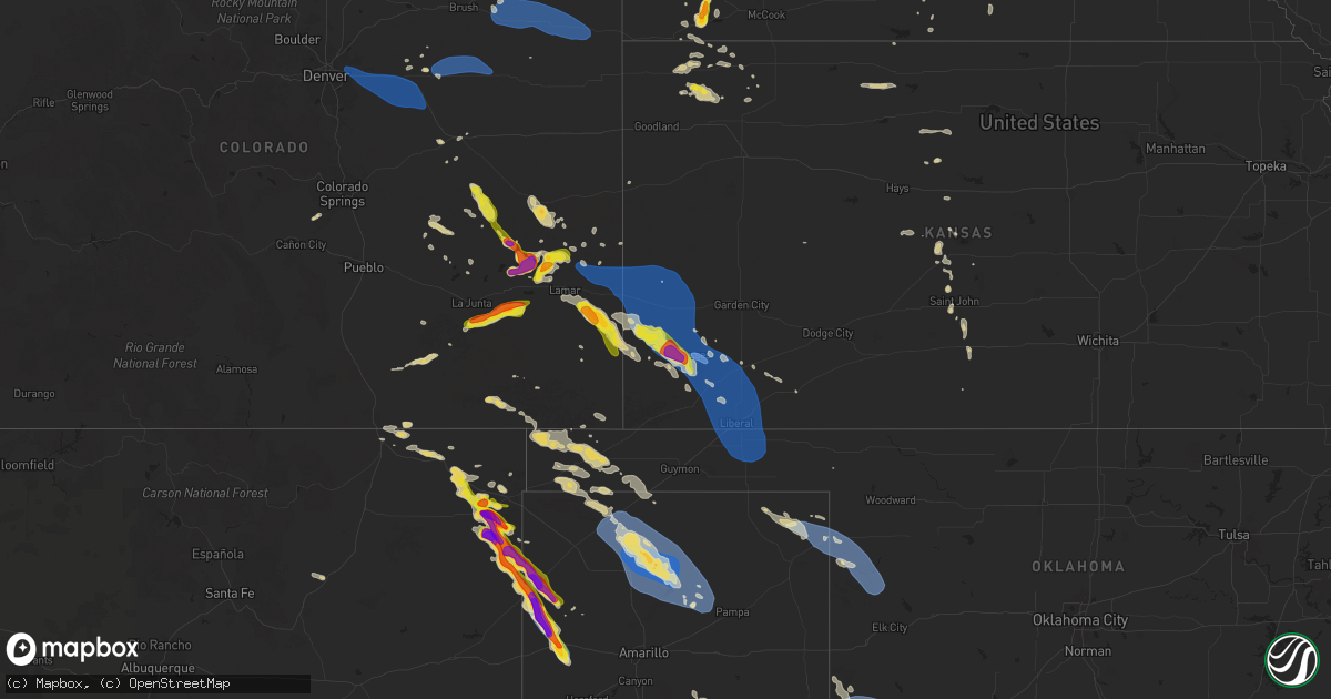
Hail Map on August 2, 2025
Get this storm
August 2 map
$229
one time, instant access
Download today. No call, no setup
Keep the $229
Bought the map and want the full workflow? Apply the entire $229 to a subscription within 7 days. None of it is wasted.
Every map, not just this one
This buys you this map. Subscription and you get every map we run, in the markets you choose from a few cities to whole states to nationwide. Plus real-time alerts the moment a storm fires.
Contact data
Name, contact info, occupancy, even credit band for addresses in the footprint. You go from where it hit to who to call.
Become the source they trust
Unlimited branding weather history reports on demand. You already have the documented answer ready for the property owner, and you are the one who showed up with it.
Property data and RoofTrace estimates
Pull up any address you have got, its value and the exact code rules for that jurisdiction, straight from One Click Code. Then RoofTrace estimates the squares, pitch, and roof value, priced the way you price.
States Impacted by Hail Map on August 2, 2025
Storm reports
Utah
| Date | Description |
|---|---|
| 08/02/20255:30 PM CDT | Mesonet station pc358 hansel valley. |
Oklahoma
| Date | Description |
|---|---|
| 08/02/20256:25 AM CDT | Oklahoma mesonet site. |
| 08/02/20255:55 AM CDT | Personal weather station. |
| 08/02/20255:47 AM CDT | Klts observation. |
| 08/02/20251:29 AM CDT | Report of the roof of a barn blown off on east-west 16 road. |
Idaho
| Date | Description |
|---|---|
| 08/02/20256:00 PM CDT | Mesonet station 8433 d5 franklin us-91. |
| 08/02/20255:30 PM CDT | Mesonet station itde3 d6 camas i-15. |
| 08/02/20255:25 PM CDT | Mesonet station ham 1 wnw camas. |
| 08/01/20258:55 PM CDT | Mesonet station lof inl specific manufacturing. |
Wyoming
| Date | Description |
|---|---|
| 08/02/20256:56 PM CDT | Mesonet station wy27 14.5 sw bosler |
| 08/02/20256:26 PM CDT | Corrects previous non-tstm wnd gst report from 3 nw arlington. Mesonet station wy22 2.7 nw arlington |
| 08/02/20256:12 PM CDT | Corrects previous non-tstm wnd gst report from 7 nw elk mountain. Mesonet station wy18 halleck ridge |
| 08/02/20255:30 PM CDT | Mesonet station pc457 hidden dome. |
| 08/02/20255:28 PM CDT | Asos station krwl 1 ene rawlins. |
| 08/02/20255:17 PM CDT | Mesonet station psdw4 worland 10 sse. |
| 08/02/20254:20 PM CDT | Picture of 3-inch diameter cottonwood tree branches down at hot springs state park. |
| 08/02/20254:20 PM CDT | Mesonet station pc397 warm springs. |
| 08/02/20254:15 PM CDT | Mesonet station cw8386 thermopolis. |
| 08/02/20253:18 PM CDT | Asos station krks rock springs airport. |
| 08/01/20257:36 PM CDT | Mesonet station up203 2.0 w buford |
| 08/01/20257:36 PM CDT | Mesonet station ur535 sherws. |
| 08/01/20257:30 PM CDT | Corrects previous non-tstm wnd gst report from 7 e laramie. Mesonet station pc236 pilot hill. |
New Mexico
| Date | Description |
|---|---|
| 08/01/202510:50 PM CDT | Time estimated via radar. |
| 08/01/202510:30 PM CDT | Hail caused broken windows... Dents in cars... And resulted in the death of at least 27 birds. |
| 08/01/202510:00 PM CDT | Hayden ziamet station. |
| 08/01/20258:42 PM CDT | Lasted until 8 pm or so. |
| 08/01/20257:40 PM CDT | A local report indicates 2.00 inch wind near 10 NW Sedan |
| 08/01/20257:30 PM CDT | A local report indicates 1.00 inch wind near 10 NW Sedan |
| 08/01/20257:25 PM CDT | A local report indicates 1.75 inch wind near 13 NW Sedan |
| 08/01/20257:14 PM CDT | A local report indicates 1.00 inch wind near 13 NW Sedan |
Kansas
| Date | Description |
|---|---|
| 08/02/202512:47 AM CDT | Mesonet ur350. |
| 08/02/202512:42 AM CDT | Corrects previous tstm wnd dmg report from 8 nw kismet. Seward county em reported17 power poles down roughly 3 miles east of the us-160 and us-83 intersection. Time est |
| 08/02/202512:42 AM CDT | Seward county em sent a picture of power poles down roughly 3 miles east of the us-160 and us-83 intersection. Time estimated from radar. |
| 08/02/202512:38 AM CDT | Mesonet up407. |
| 08/02/202512:32 AM CDT | Em reported tin roof peeled back on an outbuilding and light post leaning. |
| 08/02/202512:29 AM CDT | Semi blown over from thunderstorm wind. Time estimated via radar. |
| 08/02/202512:29 AM CDT | Seward county em reported estimated 60 mph wind gusts at us-160 and us-83. |
| 08/02/202512:28 AM CDT | Mesonet station up407 0.6 sw hayne |
| 08/02/202512:04 AM CDT | Kansas state mesonet in satanta. |
| 08/01/202511:00 PM CDT | Electrical poles broken and down. Report via social media. |
| 08/01/202510:58 PM CDT | Ambient weather network site: videra weather. |
| 08/01/202510:32 PM CDT | Kjhn reported wind gust 94 mph. |
| 08/01/202510:30 PM CDT | Estimated 50-60 mph wi |
| 08/01/202510:30 PM CDT | Estimated 50-60 mph winds were also reported at the same location at this time. The time was estimated by radar. |
| 08/01/202510:20 PM CDT | Public reported up to 6 inch tree limbs broken. Time estimated via radar. |
| 08/01/202510:20 PM CDT | Public reported quarter size hail. |
| 08/01/202510:10 PM CDT | Estimated 50 to 60 mph wind gusts. Quarter sized hail was also reported at the same time and location. Time was estimated by radar. |
Georgia
| Date | Description |
|---|---|
| 08/02/20253:50 PM CDT | Tree reported down on fort mcallister road near whitehall lane. Time estimated from radar. |
Texas
| Date | Description |
|---|---|
| 08/02/20252:59 PM CDT | Trained spotter reported a 60 mph wind gust with a handheld anemometer in morgans point. |
| 08/02/20253:17 AM CDT | Reports via social media of 6 to 7 inch diameter tree branches down in the area. |
| 08/02/20253:12 AM CDT | A local report indicates 68 MPH wind near 2 WNW Fritch |
| 08/02/20252:31 AM CDT | A local report indicates 60 MPH wind near 3 SE Dumas |
| 08/02/20252:30 AM CDT | Emergency manager got reports of power out in sunray and multiple reports of damage... From downed buildings... To power poles snapped in half... Trees down bloacking r |
| 08/02/20252:28 AM CDT | A local report indicates 64 MPH wind near 8 W Lipscomb |
| 08/02/202512:34 AM CDT | Timing for report was based off radar estimate. |
| 08/01/202511:50 PM CDT | A local report indicates 74 MPH wind near 11 S Romero |
| 08/01/202511:10 PM CDT | A local report indicates 1.25 inch wind near Romero |
Colorado
| Date | Description |
|---|---|
| 08/02/20256:46 PM CDT | Awos station kako akron. |
| 08/02/20255:48 PM CDT | Report from mping: quarter |
| 08/02/20255:41 PM CDT | Report from mping: quarter |
| 08/02/20255:35 PM CDT | Mesonet station csu71. |
| 08/02/20255:23 PM CDT | Mesonet station co |
| 08/02/20255:23 PM CDT | Mesonet station co198 aurora i-70/airport blvd. |
| 08/01/20258:45 PM CDT | Mesonet station hly02 holly no. 2. |
| 08/01/20257:46 PM CDT | Report from mping: ping pong ball |
| 08/01/20257:02 PM CDT | Station name yuma dairy. |
Nebraska
| Date | Description |
|---|---|
| 08/01/20258:55 PM CDT | Personal weather station on the west side of benkelman. |
| 08/01/20258:40 PM CDT | A local report indicates 1.50 inch wind near 5 NW Stratton |
Cities Impacted by Hail Map on August 2, 2025
- Mud Butte, SD
- Union Center, SD
- Buffalo, MT
- Alma, GA
- Blackshear, GA
- McRae Helena, GA
- Baxley, GA
- Roosevelt, TX
- Trinchera, CO
- Rocksprings, TX
- Opelika, AL
- Phenix City, AL
- Junction, TX
- Sonora, TX
- Salem, AL
- Surrency, GA
- Moody, TX
- Gatesville, TX
- Lorida, FL
- Round Mountain, TX
- Spicewood, TX
- Jewett, TX
- Caldwell, TX
- Temple, TX
- Belton, TX
- Chester, MT
- Hunt, TX
- Marquez, TX
- Little River Academy, TX
- Holland, TX
- Rogers, TX
- Ocate, NM
- Thorndale, TX
- Lexington, TX
- Fredericksburg, TX
- Watrous, NM
- Paige, TX
- Giddings, TX
- Burton, TX
- Brenham, TX
- Vanderpool, TX
- Burns, WY
- Cheyenne, WY
- Albin, WY
- Buckholts, TX
- Rockdale, TX
- San Saba, TX
- Eldorado, TX
- Ozona, TX
- Lolita, TX
- Kim, CO
- Pine Bluffs, WY
- Arenas Valley, NM
- Uvalde, TX
- La Grange, TX
- Limon, CO
- Grenville, NM
- Clayton, NM
- Byers, CO
- Harrison, NE
- Strasburg, CO
- Aurora, CO
- Watkins, CO
- Bennett, CO
- Deer Trail, CO
- Agate, CO
- Briggsdale, CO
- Rush, CO
- Model, CO
- Trinidad, CO
- Raton, NM
- Hugo, CO
- Karval, CO
- Fort Morgan, CO
- Ordway, CO
- New Raymer, CO
- Woodrow, CO
- Lindon, CO
- Stoneham, CO
- Alliance, NE
- Socorro, NM
- Goliad, TX
- Bridger, MT
- Carrizo Springs, TX
- La Junta, CO
- Akron, CO
- Merino, CO
- Penrose, CO
- Canon City, CO
- Capulin, NM
- Kit Carson, CO
- Las Animas, CO
- Lodge Grass, MT
- Florissant, CO
- Des Moines, NM
- Sterling, CO
- Three Rivers, TX
- George West, TX
- Haswell, CO
- Folsom, NM
- Rushville, NE
- Hasty, CO
- Calliham, TX
- Tilden, TX
- Eads, CO
- Utopia, TX
- Big Wells, TX
- Otis, CO
- Yuma, CO
- Wray, CO
- Eckley, CO
- McClave, CO
- Winnett, MT
- Freer, TX
- Sedan, NM
- Wiley, CO
- San Diego, TX
- Lambert, MT
- Sheridan Lake, CO
- Weskan, KS
- Olney Springs, CO
- Roundup, MT
- Realitos, TX
- Stratton, NE
- Whitetail, MT
- Venango, NE
- Palisade, NE
- Pine Ridge, SD
- Scobey, MT
- Holly, CO
- Syracuse, KS
- Tribune, KS
- Wounded Knee, SD
- Benkelman, NE
- Max, NE
- Flaxville, MT
- McDonald, KS
- Coolidge, KS
- Kendall, KS
- Pritchett, CO
- Bird City, KS
- Atwood, KS
- Johnson, KS
- Lakin, KS
- Amistad, NM
- Lamar, CO
- Ulysses, KS
- Manter, KS
- Dalhart, TX
- Granada, CO
- Torrington, WY
- Nara Visa, NM
- Fayetteville, TX
- Colby, KS
- Outlook, MT
- Levant, KS
- Raymond, MT
- Hartley, TX
- Milan, GA
- Channing, TX
- Kenton, OK
- Satanta, KS
- Sublette, KS
- Moscow, KS
- Hugoton, KS
- Kismet, KS
- Reserve, MT
- Adrian, TX
- Boise City, OK
- Liberal, KS
- Walsh, CO
- Lenora, KS
- Plentywood, MT
- Vega, TX
- Logan, NM
- Ludell, KS
- Keyes, OK
- Logan, KS
- Prairie View, KS
- Plains, KS
- Broadus, MT
- Hooker, OK
- Tyrone, OK
- Turpin, OK
- Forgan, OK
- La Crosse, KS
- Phillipsburg, KS
- Natoma, KS
- Glade, KS
- Bison, KS
- Woodston, KS
- Texhoma, OK
- Naponee, NE
- Hildreth, NE
- Bloomfield, NE
- Paradise, KS
- Felt, OK
- Bloomington, NE
- Franklin, NE
- Great Bend, KS
- Meade, KS
- Hereford, TX
- Alton, KS
- Albert, KS
- Beaver, OK
- Balko, OK
- St John, KS
- Hoisington, KS
- Pawnee Rock, KS
- Russell, KS
- Stratford, TX
- Waldo, KS
- Macksville, KS
- Dumas, TX
- Cactus, TX
- Sunray, TX
- Blue Hill, NE
- Stafford, KS
- Turon, KS
- Iuka, KS
- Perryton, TX
- Ellinwood, KS
- Pratt, KS
- Booker, TX
- Gruver, TX
- Morse, TX
- Stinnett, TX
- Follett, TX
- Sawyer, KS
- Higgins, TX
- Canadian, TX
- Lipscomb, TX
- Medicine Lodge, KS
- Masterson, TX
- Arnett, OK
- Fritch, TX
- Borger, TX
- Panhandle, TX
- Skellytown, TX
- Durham, OK
- Crawford, OK
- Cheyenne, OK
- Hammon, OK
- Leedey, OK
- Campo, CO
- Hollis, OK
- Vinson, OK
- Goodwell, OK
- Claude, TX
- Altus, OK
- Olustee, OK
- Gould, OK
- Duke, OK
- Blair, OK
- Mangum, OK
- Elmer, OK
- Altus Afb, OK
- Eldorado, OK
- Quanah, TX
- Headrick, OK
- Chillicothe, TX
- Tipton, OK
- Quitaque, TX
- Vernon, TX
- Odell, TX
- Frederick, OK
- Davidson, OK
- Denver, CO
- Otis, KS
- Guide Rock, NE
- Osborne, KS
- Oklaunion, TX
- Harrold, TX
- Hollister, OK
- Loveland, OK
- Crowell, TX