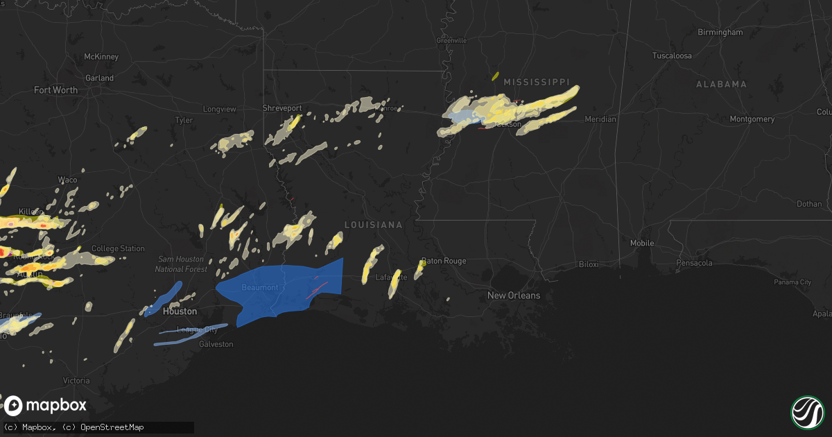
Hail Map in Louisiana on April 9, 2024
Get this storm
April 9 map
$229
one time, instant access
Download today. No call, no setup
Keep the $229
Bought the map and want the full workflow? Apply the entire $229 to a subscription within 7 days. None of it is wasted.
Every map, not just this one
This buys you this map. Subscription and you get every map we run, in the markets you choose from a few cities to whole states to nationwide. Plus real-time alerts the moment a storm fires.
Contact data
Name, contact info, occupancy, even credit band for addresses in the footprint. You go from where it hit to who to call.
Become the source they trust
Unlimited branding weather history reports on demand. You already have the documented answer ready for the property owner, and you are the one who showed up with it.
Property data and RoofTrace estimates
Pull up any address you have got, its value and the exact code rules for that jurisdiction, straight from One Click Code. Then RoofTrace estimates the squares, pitch, and roof value, priced the way you price.
Storm reports in Louisiana
Louisiana
| Date | Description |
|---|---|
| 04/09/20246:45 PM CDT | Trees and line down around rayville... Also on davis lake road. |
| 04/09/20246:38 PM CDT | Tree downed across us 425 south of mer rouge. |
| 04/09/20246:34 PM CDT | A few trees down on crew lake road and collins road. |
| 04/09/20246:28 PM CDT | Trees downed along la 139 between dewey brown rd and the parish line. |
| 04/09/20246:23 PM CDT | Kmlu metar measured a wind gust of 62 mph. |
| 04/09/20246:10 PM CDT | Trees down... Some snapped on the campus of the university of louisiana monroe. |
| 04/09/20246:00 PM CDT | Trees were downed across i-20 eastbound at mile marker 101 in calhoun... Forcing the closure of the interstate for a few hours. |
| 04/09/20245:30 PM CDT | Trees down blocking the 500 block of highway 479 near chestnut. |
| 04/09/20245:25 PM CDT | Trees were downed across the 500 block of highway 120 in marthaville. Numerous other trees were downed across multiple other locations across central and northern natch |
| 04/09/20245:00 PM CDT | Tree down on hwy 71 near coushatta. |
| 04/09/20244:41 PM CDT | Observed large branches down along us hwy 71 se of atkins... La. Measured a 64mph wind gust near mary magdalene cemetary along us 71. |
| 04/09/20244:30 PM CDT | Tree down on corner of poinsetta and crabapple. |
| 04/09/20246:54 AM CDT | Awos station kcwf chenault lk chas. |
| 04/09/20246:49 AM CDT | Mesonet stat |
| 04/09/20246:49 AM CDT | M |
| 04/09/20246:49 AM CDT | Mesonet station hakl1 sabine. |
| 04/09/20246:40 AM CDT | Possible tornado on ryan st. At library riot. |
| 04/09/20246:40 AM CDT | So reported tornado. |
| 04/09/20246:39 AM CDT | Nws employee reports multiple manufactured sheds blown into the road. |
| 04/09/20246:39 AM CDT | Trees snapped off. |
| 04/09/20246:38 AM CDT | An ef 2 tornado with max winds of 115 mph touched down near vernon road on the eastern side of mcneese state university and crossed common... Center... Harvard and kirk |
| 04/09/20246:37 AM CDT | Asos station klch lake charles. |
| 04/09/20246:31 AM CDT | The tornado touched down to the south of la-384 near honore lane... Damaging trees as it headed northeast toward the intracoastal waterway. The tornado continued throug |
| 04/09/20246:30 AM CDT | The tornado began near the intersection of herbert camp rd and big pasture road... Resulting in ef0-ef1 tree damage as it headed northeast. Surging winds to the south o |
| 04/09/20246:20 AM CDT | A large tree snapped and was completely blocking the road at this location. Photos received via facebook. |
| 04/09/20246:03 AM CDT | Report from mping: 1-inch tree limbs broken; shingles blown off. |
| 04/08/202411:30 PM CDT | Report of large trees down on hwy 464 ne of merryville. |
| 04/08/20248:53 PM CDT | Multiple trees and power lines down at kites marina. |
| 04/08/20247:23 PM CDT | Numerous trees down around town... Several power lines down. Gas station awning blown off. |
| 04/08/20247:00 PM CDT | Multiple trees downed in franklin parish. |
All States Impacted by Hail Map on April 9, 2024
Cities Impacted by Hail Map on April 9, 2024
- Snyder, TX
- Justiceburg, TX
- Girard, TX
- Frankston, TX
- Palestine, TX
- Jayton, TX
- Spur, TX
- Aspermont, TX
- Dickens, TX
- Stonewall, LA
- Frierson, LA
- Shreveport, LA
- Old Glory, TX
- Paducah, TX
- Elgin, TX
- Austin, TX
- Roscoe, TX
- Seymour, TX
- Thrall, TX
- Sweetwater, TX
- Thorndale, TX
- Lexington, TX
- Buckholts, TX
- Cameron, TX
- Davilla, TX
- Rockdale, TX
- Hutto, TX
- Taylor, TX
- Georgetown, TX
- Round Rock, TX
- Pflugerville, TX
- Roby, TX
- Granger, TX
- Merkel, TX
- Benjamin, TX
- Munday, TX
- Knox City, TX
- Lott, TX
- Jarrell, TX
- Bartlett, TX
- Salado, TX
- Anson, TX
- Rule, TX
- Stamford, TX
- Sylvester, TX
- Hawley, TX
- Rochester, TX
- Belton, TX
- Lampasas, TX
- Burnet, TX
- Chilton, TX
- Eddy, TX
- Moody, TX
- Troy, TX
- Temple, TX
- Haskell, TX
- Llano, TX
- Lorena, TX
- O'Brien, TX
- McCaulley, TX
- Weinert, TX
- McGregor, TX
- Abilene, TX
- Avoca, TX
- Kingsland, TX
- Mount Calm, TX
- Axtell, TX
- Lueders, TX
- Goree, TX
- Marble Falls, TX
- Throckmorton, TX
- Riesel, TX
- Killeen, TX
- Mart, TX
- Albany, TX
- Harker Heights, TX
- Lockney, TX
- Trinidad, TX
- Kerens, TX
- Malakoff, TX
- Corsicana, TX
- Bertram, TX
- Athens, TX
- Bruceville, TX
- Woodway, TX
- Maryneal, TX
- Robert Lee, TX
- Mabank, TX
- Eustace, TX
- Blackwell, TX
- Olney, TX
- Holliday, TX
- Wichita Falls, TX
- Lometa, TX
- Windthorst, TX
- Archer City, TX
- Scotland, TX
- Silverton, TX
- Quitaque, TX
- Clarendon, TX
- Gatesville, TX
- Evant, TX
- Henrietta, TX
- Floydada, TX
- Hamilton, TX
- Purmela, TX
- Jonesboro, TX
- Laneville, TX
- Mount Enterprise, TX
- Henderson, TX
- Long Branch, TX
- Carthage, TX
- Gary, TX
- Garrison, TX
- Timpson, TX
- Beckville, TX
- Keatchie, LA
- Grand Cane, LA
- Logansport, LA
- Gloster, LA
- Mansfield, LA
- Brady, TX
- Elm Grove, LA
- Bossier City, LA
- Shelbyville, TX
- Mason, TX
- Voca, TX
- Converse, LA
- Ringgold, LA
- Fredonia, TX
- San Saba, TX
- Pleasant Hill, LA
- Pelican, LA
- Heflin, LA
- Manor, TX
- Pontotoc, TX
- Cherokee, TX
- Bienville, LA
- Coushatta, LA
- Marthaville, LA
- Jamestown, LA
- Castor, LA
- Valley Spring, TX
- Saline, LA
- Campti, LA
- Simsboro, LA
- Arcadia, LA
- Ruston, LA
- Quitman, LA
- Art, TX
- Goldonna, LA
- Choudrant, LA
- Grambling, LA
- Tow, TX
- Calhoun, LA
- Downsville, LA
- Coupland, TX
- Eros, LA
- West Monroe, LA
- Dodson, LA
- Dripping Springs, TX
- Bluffton, TX
- Monroe, LA
- Rayville, LA
- Sikes, LA
- Fredericksburg, TX
- Olla, LA
- Oak Ridge, LA
- Columbia, LA
- Doss, TX
- Grayson, LA
- Kempner, TX
- Briggs, TX
- Woodville, TX
- Kelly, LA
- Round Mountain, TX
- Spicewood, TX
- Willow City, TX
- Leander, TX
- Nacogdoches, TX
- Colmesneil, TX
- Childress, TX
- Robeline, LA
- Doyline, LA
- Florence, TX
- Vicksburg, MS
- Sterlington, LA
- Horseshoe Bay, TX
- Jasper, TX
- Valley Park, MS
- Livingston, TX
- Liberty, TX
- Redwood, MS
- Tallulah, LA
- Johnson City, TX
- Liberty Hill, TX
- Warren, TX
- Hye, TX
- Cleveland, TX
- Broaddus, TX
- Bolton, MS
- Edwards, MS
- Quanah, TX
- Chester, TX
- Satartia, MS
- Bronson, TX
- Pineland, TX
- Cedar Park, TX
- Raymond, MS
- Flora, MS
- Bentonia, MS
- Chillicothe, TX
- Holland, TX
- Blanco, TX
- Boerne, TX
- Saratoga, TX
- Rogers, TX
- Little River Academy, TX
- Jackson, MS
- Madison, MS
- Clinton, MS
- Kendalia, TX
- Hull, TX
- Ridgeland, MS
- Yazoo City, MS
- Driftwood, TX
- Florien, LA
- Manchaca, TX
- Buda, TX
- Fred, TX
- Hillister, TX
- Canton, MS
- Kountze, TX
- Belmont, LA
- Batson, TX
- Tougaloo, MS
- Brandon, MS
- Davidson, OK
- Frederick, OK
- Elmer, OK
- Vernon, TX
- Odell, TX
- Tipton, OK
- Eldorado, OK
- Del Valle, TX
- Olustee, OK
- Wimberley, TX
- Pearl, MS
- Flowood, MS
- Burlington, TX
- Hondo, TX
- D Hanis, TX
- Haughton, LA
- Headrick, OK
- Altus, OK
- Hollister, OK
- Cedar Creek, TX
- Bergheim, TX
- Spring Branch, TX
- Bulverde, TX
- Sabinal, TX
- Pelahatchie, MS
- Lena, MS
- Rosebud, TX
- Bastrop, TX
- Harrold, TX
- Loveland, OK
- Grandfield, OK
- Snyder, OK
- Morton, MS
- Chattanooga, OK
- Walters, OK
- Mountain Park, OK
- Indiahoma, OK
- Batesville, TX
- Spurger, TX
- Castroville, TX
- Paige, TX
- Devol, OK
- Forest, MS
- Smithville, TX
- Carthage, MS
- Faxon, OK
- Cache, OK
- Canyon Lake, TX
- Florence, MS
- Rio Medina, TX
- Mico, TX
- San Antonio, TX
- Helotes, TX
- Braxton, MS
- McDade, TX
- Big Wells, TX
- Asherton, TX
- Carrizo Springs, TX
- Laredo, TX
- Yancey, TX
- Lawton, OK
- Geronimo, OK
- Encinal, TX
- Walnut Grove, MS
- Philadelphia, MS
- Union, MS
- Sebastopol, MS
- Cotulla, TX
- Catarina, TX
- Kirbyville, TX
- Call, TX
- Devine, TX
- Conehatta, MS
- Fort Sill, OK
- Medicine Park, OK
- Moore, TX
- Bon Wier, TX
- Bremond, TX
- Jbsa Lackland, TX
- La Coste, TX
- Reagan, TX
- Newton, TX
- Pearsall, TX
- Pulaski, MS
- Caldwell, TX
- Dime Box, TX
- Elgin, OK
- Marlow, OK
- Rush Springs, OK
- Duncan, OK
- Fletcher, OK
- Marlin, TX
- Natalia, TX
- Poteet, TX
- Lytle, TX
- Merryville, LA
- Lincoln, TX
- Crystal City, TX
- Somerville, TX
- Lake, MS
- Moscow, TX
- Corrigan, TX
- Converse, TX
- Somerset, TX
- Kosse, TX
- Burkeville, TX
- Adkins, TX
- Lawrence, MS
- Jbsa Ft Sam Houston, TX
- Von Ormy, TX
- Schertz, TX
- Universal City, TX
- Jbsa Randolph, TX
- Saint Hedwig, TX
- Cibolo, TX
- Seguin, TX
- Marion, TX
- New Braunfels, TX
- McQueeney, TX
- Bradley, OK
- Lindsay, OK
- Franklin, TX
- Decatur, MS
- Dilley, TX
- La Vernia, TX
- Thornton, TX
- Evans, LA
- Deridder, LA
- Lyons, TX
- Kingsbury, TX
- Fowlerton, TX
- Snook, TX
- Pleasanton, TX
- Elmendorf, TX
- Floresville, TX
- Jewett, TX
- Marquez, TX
- Charlotte, TX
- Diboll, TX
- Lufkin, TX
- Maysville, OK
- Wayne, OK
- Tilden, TX
- Pauls Valley, OK
- Giddings, TX
- Navasota, TX
- College Station, TX
- Jourdanton, TX
- Luling, TX
- Donie, TX
- Paoli, OK
- Leesville, TX
- Nixon, TX
- Purcell, OK
- Buffalo, TX
- Wanette, OK
- Byars, OK
- Lexington, OK
- Calliham, TX
- Gonzales, TX
- Cost, TX
- Whitsett, TX
- Three Rivers, TX
- Karnes City, TX
- Moulton, TX
- Leesville, LA
- Smiley, TX
- Westhoff, TX
- Hobson, TX
- Huntington, TX
- Zavalla, TX
- Cuero, TX
- New Llano, LA
- Flatonia, TX
- Schulenburg, TX
- Fort Polk, LA
- Weimar, TX
- Yoakum, TX
- East Bernard, TX
- La Grange, TX
- Edna, TX
- Louise, TX
- El Campo, TX
- Wallis, TX
- Fayetteville, TX
- Eagle Lake, TX
- Fulshear, TX
- Brookshire, TX
- Katy, TX
- Wharton, TX
- Mayersville, MS
- Sondheimer, LA
- Cypress, TX
- Newellton, LA
- Rolling Fork, MS
- Tomball, TX
- Copperas Cove, TX
- Houston, TX
- Onalaska, TX
- Crosby, TX
- Humble, TX
- Huffman, TX
- Ragley, LA
- Reeves, LA
- Kinder, LA
- Dry Creek, LA
- Napoleonville, LA
- Erath, LA
- Mittie, LA
- Oberlin, LA
- New Iberia, LA
- Delcambre, LA
- Pitkin, LA
- Youngsville, LA
- Abbeville, LA
- Broussard, LA
- Lafayette, LA
- Breaux Bridge, LA
- Saint Martinville, LA
- Crowley, LA
- Morse, LA
- Estherwood, LA
- Oakdale, LA
- Buna, TX
- Bandera, TX
- Rayne, LA
- Iota, LA
- Branch, LA
- Church Point, LA
- Egan, LA
- Eunice, LA
- Anahuac, TX
- Port Bolivar, TX
- Port Arthur, TX
- Winnie, TX
- Sabine Pass, TX
- Beaumont, TX
- Cameron, LA
- Groves, TX
- Bridge City, TX
- Vinton, LA
- Hackberry, LA
- Sulphur, LA
- Dequincy, LA
- Orange, TX
- Starks, LA
- Deweyville, TX
- Vidor, TX
- Port Neches, TX
- China, TX
- Lumberton, TX
- Nederland, TX
- Hamshire, TX
- Opelousas, LA
- Ville Platte, LA
- Lake Charles, LA
- Westlake, LA
- Grosse Tete, LA
- Maringouin, LA
- Bell City, LA
- Lacassine, LA
- Iowa, LA
- Jennings, LA
- Lake Arthur, LA
- Elton, LA
- Welsh, LA
- Rosedale, LA
- Washington, LA
- Richmond, TX
- Spring, TX
- Porter, TX
- Conroe, TX
- Damon, TX
- Rosharon, TX
- Alvin, TX
- Santa Fe, TX
- Dickinson, TX
- Texas City, TX
- La Marque, TX
- Bacliff, TX
- League City, TX
- Missouri City, TX
- Manvel, TX
- Pearland, TX
- Friendswood, TX
- Webster, TX
- Devers, TX
- Sour Lake, TX
- Silsbee, TX
- Nome, TX


