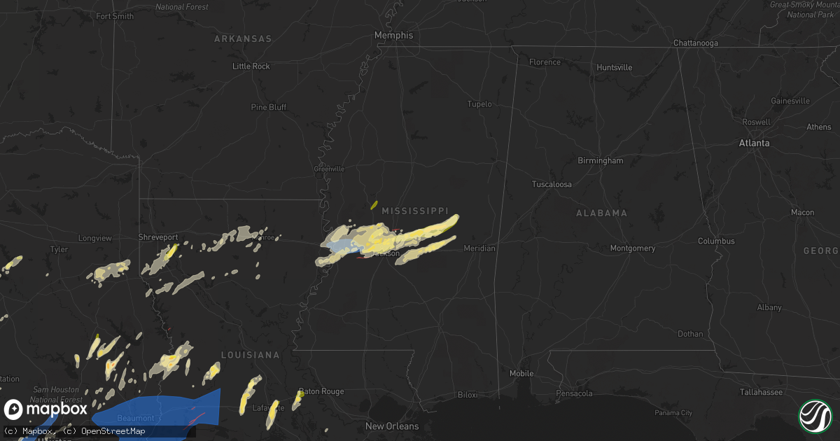
Hail Map in Mississippi on April 9, 2024
Get this storm
April 9 map
$229
one time, instant access
Download today. No call, no setup
Keep the $229
Bought the map and want the full workflow? Apply the entire $229 to a subscription within 7 days. None of it is wasted.
Every map, not just this one
This buys you this map. Subscription and you get every map we run, in the markets you choose from a few cities to whole states to nationwide. Plus real-time alerts the moment a storm fires.
Contact data
Name, contact info, occupancy, even credit band for addresses in the footprint. You go from where it hit to who to call.
Become the source they trust
Unlimited branding weather history reports on demand. You already have the documented answer ready for the property owner, and you are the one who showed up with it.
Property data and RoofTrace estimates
Pull up any address you have got, its value and the exact code rules for that jurisdiction, straight from One Click Code. Then RoofTrace estimates the squares, pitch, and roof value, priced the way you price.
Storm reports in Mississippi
Mississippi
| Date | Description |
|---|---|
| 04/09/20244:39 AM CDT | Tree downed on a house in the ashbrooke subdivision. |
| 04/09/20244:39 AM CDT | Several trees down and some damage to homes around lake caroline and stribling rd. Possible tornado. |
| 04/09/20243:30 AM CDT | Multiple reports of trees downed on houses; bell island rd... Hanging moss rd... Sea island dr... Douglass rd... Hill dale dr... Etc... |
| 04/08/202411:00 PM CDT | Tree downed on roof. |
| 04/08/202410:55 PM CDT | Multiple trees downed on roads; hugh mitchell rd... Hoye pace rd... |
| 04/08/202410:42 PM CDT | *** 2 inj *** mobile homes rolled and damaged and trees down along johnson town rd. |
| 04/08/202410:30 PM CDT | A metal barn was collapsed in the good hope community. |
| 04/08/202410:20 PM CDT | Several trees downed in the dixon area... With trees downed on houses in the dixon community and the hope community. |
| 04/08/202410:05 PM CDT | Reports of multiple trees downed on roads; russsell community rd... Old hwy 80... Salem rd... Etc... |
| 04/08/202410:00 PM CDT | Quarter-sized hail was reported in lena... Ms. |
| 04/08/202410:00 PM CDT | Multiple trees downed on roads; sunnyside dr... Grand ave... Etc... |
| 04/08/20249:51 PM CDT | Dime to quarter size hail reported near the ludlow fire station. |
| 04/08/20249:40 PM CDT | Multiple trees down along hwy 483 between the ludlow fire station and first baptist church. |
| 04/08/20249:06 PM CDT | Trees and fences were downed in numerous locations within gluckstadt including clarkdell road and stout road. |
| 04/08/20249:03 PM CDT | Power line down blocking hwy 51. |
| 04/08/20249:02 PM CDT | Trees down on rice rd. |
| 04/08/20249:02 PM CDT | Hail up to the size of quarters fell in ridgeland. Report relayed via spotter network. |
| 04/08/20249:00 PM CDT | Multiple trees down and damage to a roof in the sheffield area of jackson. |
| 04/08/20248:59 PM CDT | A tree was blown down in the providence subdivision in gluckstadt. |
| 04/08/20248:56 PM CDT | Multiple trees down in madison on bozeman rd. |
| 04/08/20248:46 PM CDT | A local report indicates 1.00 inch wind near Pocahontas |
| 04/08/20248:41 PM CDT | Quarter size hail reported. |
| 04/08/20248:41 PM CDT | Several trees down near hidden lake rd. |
| 04/08/20248:38 PM CDT | Tree down on a car. |
| 04/08/20248:27 PM CDT | Trees and lines down on bill downing rd... Possible tornado. |
| 04/08/20248:23 PM CDT | Trees down. |
| 04/08/20248:22 PM CDT | Tree down on old port gibson rd. |
| 04/08/20248:16 PM CDT | Quarter size hail reported near eden. |
| 04/08/20247:55 PM CDT | Report of quarter sized hail. |
| 04/08/20247:53 PM CDT | Several trees down in the redwood and oak ridge areas. |
| 04/08/20247:52 PM CDT | Numerous trees were blown down on multiple vehicles along interstate 20 east. Report relayed via spotter network. |
| 04/08/20247:52 PM CDT | Tree down across forest hill circle. |
| 04/08/20247:50 PM CDT | Widespread downed trees and numerous power lines down in vicksburg. |
| 04/08/20247:42 PM CDT | Corrects previous tstm wnd dmg report from 10 nw kings. Multiple reports of trees downed on houses; bell island rd... Hanging moss rd... Sea island dr... Douglass rd... |
| 04/08/20247:40 PM CDT | Roof damage to a home on eagle lake. |
All States Impacted by Hail Map on April 9, 2024
Cities Impacted by Hail Map on April 9, 2024
- Snyder, TX
- Justiceburg, TX
- Girard, TX
- Frankston, TX
- Palestine, TX
- Jayton, TX
- Spur, TX
- Aspermont, TX
- Dickens, TX
- Stonewall, LA
- Frierson, LA
- Shreveport, LA
- Old Glory, TX
- Paducah, TX
- Elgin, TX
- Austin, TX
- Roscoe, TX
- Seymour, TX
- Thrall, TX
- Sweetwater, TX
- Thorndale, TX
- Lexington, TX
- Buckholts, TX
- Cameron, TX
- Davilla, TX
- Rockdale, TX
- Hutto, TX
- Taylor, TX
- Georgetown, TX
- Round Rock, TX
- Pflugerville, TX
- Roby, TX
- Granger, TX
- Merkel, TX
- Benjamin, TX
- Munday, TX
- Knox City, TX
- Lott, TX
- Jarrell, TX
- Bartlett, TX
- Salado, TX
- Anson, TX
- Rule, TX
- Stamford, TX
- Sylvester, TX
- Hawley, TX
- Rochester, TX
- Belton, TX
- Lampasas, TX
- Burnet, TX
- Chilton, TX
- Eddy, TX
- Moody, TX
- Troy, TX
- Temple, TX
- Haskell, TX
- Llano, TX
- Lorena, TX
- O'Brien, TX
- McCaulley, TX
- Weinert, TX
- McGregor, TX
- Abilene, TX
- Avoca, TX
- Kingsland, TX
- Mount Calm, TX
- Axtell, TX
- Lueders, TX
- Goree, TX
- Marble Falls, TX
- Throckmorton, TX
- Riesel, TX
- Killeen, TX
- Mart, TX
- Albany, TX
- Harker Heights, TX
- Lockney, TX
- Trinidad, TX
- Kerens, TX
- Malakoff, TX
- Corsicana, TX
- Bertram, TX
- Athens, TX
- Bruceville, TX
- Woodway, TX
- Maryneal, TX
- Robert Lee, TX
- Mabank, TX
- Eustace, TX
- Blackwell, TX
- Olney, TX
- Holliday, TX
- Wichita Falls, TX
- Lometa, TX
- Windthorst, TX
- Archer City, TX
- Scotland, TX
- Silverton, TX
- Quitaque, TX
- Clarendon, TX
- Gatesville, TX
- Evant, TX
- Henrietta, TX
- Floydada, TX
- Hamilton, TX
- Purmela, TX
- Jonesboro, TX
- Laneville, TX
- Mount Enterprise, TX
- Henderson, TX
- Long Branch, TX
- Carthage, TX
- Gary, TX
- Garrison, TX
- Timpson, TX
- Beckville, TX
- Keatchie, LA
- Grand Cane, LA
- Logansport, LA
- Gloster, LA
- Mansfield, LA
- Brady, TX
- Elm Grove, LA
- Bossier City, LA
- Shelbyville, TX
- Mason, TX
- Voca, TX
- Converse, LA
- Ringgold, LA
- Fredonia, TX
- San Saba, TX
- Pleasant Hill, LA
- Pelican, LA
- Heflin, LA
- Manor, TX
- Pontotoc, TX
- Cherokee, TX
- Bienville, LA
- Coushatta, LA
- Marthaville, LA
- Jamestown, LA
- Castor, LA
- Valley Spring, TX
- Saline, LA
- Campti, LA
- Simsboro, LA
- Arcadia, LA
- Ruston, LA
- Quitman, LA
- Art, TX
- Goldonna, LA
- Choudrant, LA
- Grambling, LA
- Tow, TX
- Calhoun, LA
- Downsville, LA
- Coupland, TX
- Eros, LA
- West Monroe, LA
- Dodson, LA
- Dripping Springs, TX
- Bluffton, TX
- Monroe, LA
- Rayville, LA
- Sikes, LA
- Fredericksburg, TX
- Olla, LA
- Oak Ridge, LA
- Columbia, LA
- Doss, TX
- Grayson, LA
- Kempner, TX
- Briggs, TX
- Woodville, TX
- Kelly, LA
- Round Mountain, TX
- Spicewood, TX
- Willow City, TX
- Leander, TX
- Nacogdoches, TX
- Colmesneil, TX
- Childress, TX
- Robeline, LA
- Doyline, LA
- Florence, TX
- Vicksburg, MS
- Sterlington, LA
- Horseshoe Bay, TX
- Jasper, TX
- Valley Park, MS
- Livingston, TX
- Liberty, TX
- Redwood, MS
- Tallulah, LA
- Johnson City, TX
- Liberty Hill, TX
- Warren, TX
- Hye, TX
- Cleveland, TX
- Broaddus, TX
- Bolton, MS
- Edwards, MS
- Quanah, TX
- Chester, TX
- Satartia, MS
- Bronson, TX
- Pineland, TX
- Cedar Park, TX
- Raymond, MS
- Flora, MS
- Bentonia, MS
- Chillicothe, TX
- Holland, TX
- Blanco, TX
- Boerne, TX
- Saratoga, TX
- Rogers, TX
- Little River Academy, TX
- Jackson, MS
- Madison, MS
- Clinton, MS
- Kendalia, TX
- Hull, TX
- Ridgeland, MS
- Yazoo City, MS
- Driftwood, TX
- Florien, LA
- Manchaca, TX
- Buda, TX
- Fred, TX
- Hillister, TX
- Canton, MS
- Kountze, TX
- Belmont, LA
- Batson, TX
- Tougaloo, MS
- Brandon, MS
- Davidson, OK
- Frederick, OK
- Elmer, OK
- Vernon, TX
- Odell, TX
- Tipton, OK
- Eldorado, OK
- Del Valle, TX
- Olustee, OK
- Wimberley, TX
- Pearl, MS
- Flowood, MS
- Burlington, TX
- Hondo, TX
- D Hanis, TX
- Haughton, LA
- Headrick, OK
- Altus, OK
- Hollister, OK
- Cedar Creek, TX
- Bergheim, TX
- Spring Branch, TX
- Bulverde, TX
- Sabinal, TX
- Pelahatchie, MS
- Lena, MS
- Rosebud, TX
- Bastrop, TX
- Harrold, TX
- Loveland, OK
- Grandfield, OK
- Snyder, OK
- Morton, MS
- Chattanooga, OK
- Walters, OK
- Mountain Park, OK
- Indiahoma, OK
- Batesville, TX
- Spurger, TX
- Castroville, TX
- Paige, TX
- Devol, OK
- Forest, MS
- Smithville, TX
- Carthage, MS
- Faxon, OK
- Cache, OK
- Canyon Lake, TX
- Florence, MS
- Rio Medina, TX
- Mico, TX
- San Antonio, TX
- Helotes, TX
- Braxton, MS
- McDade, TX
- Big Wells, TX
- Asherton, TX
- Carrizo Springs, TX
- Laredo, TX
- Yancey, TX
- Lawton, OK
- Geronimo, OK
- Encinal, TX
- Walnut Grove, MS
- Philadelphia, MS
- Union, MS
- Sebastopol, MS
- Cotulla, TX
- Catarina, TX
- Kirbyville, TX
- Call, TX
- Devine, TX
- Conehatta, MS
- Fort Sill, OK
- Medicine Park, OK
- Moore, TX
- Bon Wier, TX
- Bremond, TX
- Jbsa Lackland, TX
- La Coste, TX
- Reagan, TX
- Newton, TX
- Pearsall, TX
- Pulaski, MS
- Caldwell, TX
- Dime Box, TX
- Elgin, OK
- Marlow, OK
- Rush Springs, OK
- Duncan, OK
- Fletcher, OK
- Marlin, TX
- Natalia, TX
- Poteet, TX
- Lytle, TX
- Merryville, LA
- Lincoln, TX
- Crystal City, TX
- Somerville, TX
- Lake, MS
- Moscow, TX
- Corrigan, TX
- Converse, TX
- Somerset, TX
- Kosse, TX
- Burkeville, TX
- Adkins, TX
- Lawrence, MS
- Jbsa Ft Sam Houston, TX
- Von Ormy, TX
- Schertz, TX
- Universal City, TX
- Jbsa Randolph, TX
- Saint Hedwig, TX
- Cibolo, TX
- Seguin, TX
- Marion, TX
- New Braunfels, TX
- McQueeney, TX
- Bradley, OK
- Lindsay, OK
- Franklin, TX
- Decatur, MS
- Dilley, TX
- La Vernia, TX
- Thornton, TX
- Evans, LA
- Deridder, LA
- Lyons, TX
- Kingsbury, TX
- Fowlerton, TX
- Snook, TX
- Pleasanton, TX
- Elmendorf, TX
- Floresville, TX
- Jewett, TX
- Marquez, TX
- Charlotte, TX
- Diboll, TX
- Lufkin, TX
- Maysville, OK
- Wayne, OK
- Tilden, TX
- Pauls Valley, OK
- Giddings, TX
- Navasota, TX
- College Station, TX
- Jourdanton, TX
- Luling, TX
- Donie, TX
- Paoli, OK
- Leesville, TX
- Nixon, TX
- Purcell, OK
- Buffalo, TX
- Wanette, OK
- Byars, OK
- Lexington, OK
- Calliham, TX
- Gonzales, TX
- Cost, TX
- Whitsett, TX
- Three Rivers, TX
- Karnes City, TX
- Moulton, TX
- Leesville, LA
- Smiley, TX
- Westhoff, TX
- Hobson, TX
- Huntington, TX
- Zavalla, TX
- Cuero, TX
- New Llano, LA
- Flatonia, TX
- Schulenburg, TX
- Fort Polk, LA
- Weimar, TX
- Yoakum, TX
- East Bernard, TX
- La Grange, TX
- Edna, TX
- Louise, TX
- El Campo, TX
- Wallis, TX
- Fayetteville, TX
- Eagle Lake, TX
- Fulshear, TX
- Brookshire, TX
- Katy, TX
- Wharton, TX
- Mayersville, MS
- Sondheimer, LA
- Cypress, TX
- Newellton, LA
- Rolling Fork, MS
- Tomball, TX
- Copperas Cove, TX
- Houston, TX
- Onalaska, TX
- Crosby, TX
- Humble, TX
- Huffman, TX
- Ragley, LA
- Reeves, LA
- Kinder, LA
- Dry Creek, LA
- Napoleonville, LA
- Erath, LA
- Mittie, LA
- Oberlin, LA
- New Iberia, LA
- Delcambre, LA
- Pitkin, LA
- Youngsville, LA
- Abbeville, LA
- Broussard, LA
- Lafayette, LA
- Breaux Bridge, LA
- Saint Martinville, LA
- Crowley, LA
- Morse, LA
- Estherwood, LA
- Oakdale, LA
- Buna, TX
- Bandera, TX
- Rayne, LA
- Iota, LA
- Branch, LA
- Church Point, LA
- Egan, LA
- Eunice, LA
- Anahuac, TX
- Port Bolivar, TX
- Port Arthur, TX
- Winnie, TX
- Sabine Pass, TX
- Beaumont, TX
- Cameron, LA
- Groves, TX
- Bridge City, TX
- Vinton, LA
- Hackberry, LA
- Sulphur, LA
- Dequincy, LA
- Orange, TX
- Starks, LA
- Deweyville, TX
- Vidor, TX
- Port Neches, TX
- China, TX
- Lumberton, TX
- Nederland, TX
- Hamshire, TX
- Opelousas, LA
- Ville Platte, LA
- Lake Charles, LA
- Westlake, LA
- Grosse Tete, LA
- Maringouin, LA
- Bell City, LA
- Lacassine, LA
- Iowa, LA
- Jennings, LA
- Lake Arthur, LA
- Elton, LA
- Welsh, LA
- Rosedale, LA
- Washington, LA
- Richmond, TX
- Spring, TX
- Porter, TX
- Conroe, TX
- Damon, TX
- Rosharon, TX
- Alvin, TX
- Santa Fe, TX
- Dickinson, TX
- Texas City, TX
- La Marque, TX
- Bacliff, TX
- League City, TX
- Missouri City, TX
- Manvel, TX
- Pearland, TX
- Friendswood, TX
- Webster, TX
- Devers, TX
- Sour Lake, TX
- Silsbee, TX
- Nome, TX


