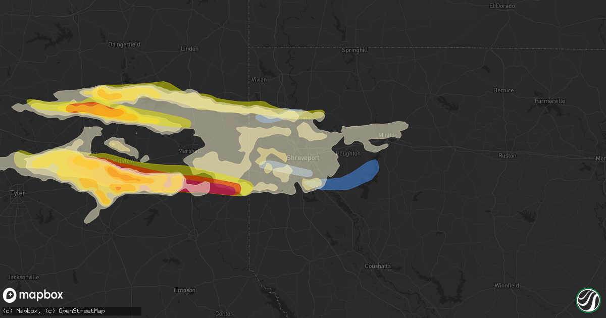
Hail Map in Shreveport, LA on April 2, 2023
Get this storm
April 2 map
$229
one time, instant access
Download today. No call, no setup
Keep the $229
Bought the map and want the full workflow? Apply the entire $229 to a subscription within 7 days. None of it is wasted.
Every map, not just this one
This buys you this map. Subscription and you get every map we run, in the markets you choose from a few cities to whole states to nationwide. Plus real-time alerts the moment a storm fires.
Contact data
Name, contact info, occupancy, even credit band for addresses in the footprint. You go from where it hit to who to call.
Become the source they trust
Unlimited branding weather history reports on demand. You already have the documented answer ready for the property owner, and you are the one who showed up with it.
Property data and RoofTrace estimates
Pull up any address you have got, its value and the exact code rules for that jurisdiction, straight from One Click Code. Then RoofTrace estimates the squares, pitch, and roof value, priced the way you price.
Storm reports in Shreveport, LA
Shreveport, LA
| Date | Description |
|---|---|
| 04/01/20237:52 PM CDT | Trees downed near dillingham ave and mitchell lane in shreveport. |
| 04/01/20237:51 PM CDT | Trees downed near fairview street and line avenue in shreveport. |
| 04/01/20237:50 PM CDT | Trees down on dixie shreveport road and george road. |
| 04/01/20237:50 PM CDT | Tree downed near quinton street... Orla ave and velva ave in shreveport. |
| 04/01/20237:49 PM CDT | A local report indicates 73 MPH wind near 2 SW SHREVEPORT |
| 04/01/20237:49 PM CDT | Tree downed into a kitchen of a home in willow ridge subdivision on the south side of cross lake. |
| 04/01/20237:43 PM CDT | Trees downed near katie circle and pine hill road in the blanchard community. |
| 04/01/20237:42 PM CDT | Trees downed near w phelps avenue... N olney and w warriner ave in the community of blanchard. |
| 04/01/20237:40 PM CDT | Trees down on the north side of blanchard. |
All States Impacted by Hail Map on April 2, 2023
All Cities Impacted by Hail Map on April 2, 2023
- Holliday, TX
- Graham, TX
- Jacksboro, TX
- Iowa Park, TX
- Wichita Falls, TX
- Perrin, TX
- Chico, TX
- Bowie, TX
- Santo, TX
- Mineral Wells, TX
- Millsap, TX
- Windthorst, TX
- Bridgeport, TX
- Henrietta, TX
- Scotland, TX
- Cleburne, TX
- Joshua, TX
- Alvarado, TX
- Burleson, TX
- Fort Worth, TX
- Haltom City, TX
- Mansfield, TX
- Lillian, TX
- Venus, TX
- Euless, TX
- Hurst, TX
- North Richland Hills, TX
- Bedford, TX
- Colleyville, TX
- Grapevine, TX
- Weatherford, TX
- Whitt, TX
- Graford, TX
- Poolville, TX
- Decatur, TX
- Alvord, TX
- Pilot Point, TX
- Tioga, TX
- Gunter, TX
- Carrollton, TX
- Dallas, TX
- Addison, TX
- Howe, TX
- Cisco, TX
- Rising Star, TX
- Bellevue, TX
- Nocona, TX
- Sherman, TX
- Lott, TX
- Chilton, TX
- Carbon, TX
- Eastland, TX
- Newcastle, TX
- Gorman, TX
- Marlow, OK
- Foster, OK
- Lindsay, OK
- Bradley, OK
- Alex, OK
- Blanchard, OK
- Plano, TX
- Desdemona, TX
- De Leon, TX
- Ranger, TX
- Marlin, TX
- Saint Jo, TX
- Dublin, TX
- Kosse, TX
- Duncan, OK
- Paradise, TX
- Irving, TX
- Springtown, TX
- Justin, TX
- Rhome, TX
- Gainesville, TX
- Era, TX
- Sanger, TX
- Valley View, TX
- Crowley, TX
- Baird, TX
- Walters, OK
- Breckenridge, TX
- Boyd, TX
- Temple, OK
- Palo Pinto, TX
- Olney, TX
- Strawn, TX
- Gordon, TX
- Garland, TX
- Rockwall, TX
- Mesquite, TX
- Rowlett, TX
- Troy, TX
- Temple, TX
- Waurika, OK
- Hastings, OK
- Byers, TX
- Bryson, TX
- Sunset, TX
- Argyle, TX
- Aledo, TX
- Naval Air Station Jrb, TX
- Kemp, TX
- Mabank, TX
- Stephenville, TX
- Muenster, TX
- Van, TX
- Ben Wheeler, TX
- Lindale, TX
- Tyler, TX
- Hico, TX
- Whitesboro, TX
- Groesbeck, TX
- Jewett, TX
- Winona, TX
- Iredell, TX
- Donie, TX
- Buffalo, TX
- Gladewater, TX
- Big Sandy, TX
- Meridian, TX
- Walnut Springs, TX
- Lampasas, TX
- Lometa, TX
- Copperas Cove, TX
- Gatesville, TX
- Oakwood, TX
- Kilgore, TX
- Longview, TX
- White Oak, TX
- Morgan, TX
- Fort Hood, TX
- Henderson, TX
- Tatum, TX
- Hallsville, TX
- Marshall, TX
- Clifton, TX
- Elkhart, TX
- Beckville, TX
- Bonham, TX
- Bailey, TX
- Leonard, TX
- Wolfe City, TX
- Ladonia, TX
- Belton, TX
- De Berry, TX
- Waskom, TX
- Whitney, TX
- Grapeland, TX
- Palestine, TX
- Bethany, LA
- Greenwood, LA
- Shreveport, LA
- Keithville, LA
- Little River Academy, TX
- Bossier City, LA
- Rogers, TX
- Elm Grove, LA
- Doyline, LA
- Haughton, LA
- Ore City, TX
- Gilmer, TX
- Buckholts, TX
- Sibley, LA
- Heflin, LA
- Diana, TX
- Winnsboro, TX
- Lone Star, TX
- Avinger, TX
- Cameron, TX
- Jefferson, TX
- Rockdale, TX
- Milano, TX
- Karnack, TX
- Harleton, TX
- Caldwell, TX
- Vivian, LA
- Oil City, LA
- Hendrix, OK
- Whitewright, TX
- Tom Bean, TX
- Caddo Mills, TX
- Celeste, TX
- Blue Ridge, TX
- Farmersville, TX
- Azle, TX
- Haslet, TX
- Holland, TX
- Ector, TX
- Thornton, TX
- Pottsboro, TX
- Aubrey, TX
- Collinsville, TX
- Marion, LA
- Arp, TX
- Overton, TX
- Goldthwaite, TX
- Ivanhoe, TX
- Telephone, TX
- Trenton, TX
- Sulphur Springs, TX
- Newark, TX
- Grand Prairie, TX
- Pittsburg, TX
- Denison, TX
- Royse City, TX
- Flower Mound, TX
- Brookston, TX
- Paris, TX
- Sumner, TX
- Roanoke, TX
- Hawkins, TX
- Quitman, TX
- Mineola, TX
- South Bend, TX
- Ravenna, TX
- Windom, TX
- Honey Grove, TX
- Savoy, TX
- Bells, TX
- Dodd City, TX
- Mooringsport, LA
- Daingerfield, TX
- Evant, TX
- Nolanville, TX
- Killeen, TX
- Krum, TX
- Lindsay, TX
- Forestburg, TX
- Montague, TX
- Rosston, TX
- Blanchard, LA
- Barksdale Afb, LA
- Belcher, LA
- Benton, LA
- Minden, LA
- Monroe, LA
- Rayville, LA
- Mangham, LA
- Delhi, LA
- Baskin, LA
- Tallulah, LA
- Winnsboro, LA
- Newellton, LA
- West Monroe, LA
- Eros, LA
- Columbia, LA
- Calhoun, LA
- Choudrant, LA
- Princeton, LA
- Vicksburg, MS
- Ruston, LA
- Port Gibson, MS
- Hermanville, MS
- Utica, MS
- Florence, MS
- Braxton, MS
- Crystal Springs, MS
- Edwards, MS
- Terry, MS
- Raymond, MS
- Mendenhall, MS
- Brandon, MS
- Hazlehurst, MS
- Georgetown, MS
- Magee, MS
- Mize, MS
- Mount Olive, MS
- Taylorsville, MS
- Stringer, MS
- Soso, MS
- Laurel, MS
- Heidelberg, MS
- Pinola, MS
- Harrisville, MS
- Frisco City, AL
- Monroeville, AL
- Vredenburgh, AL
- Grove Hill, AL
- Powderly, TX
- Tibbie, AL
- Wagarville, AL
- Yantis, TX
- Como, TX
- Athens, LA
- Alba, TX
- Stonewall, LA
- Dubberly, LA
- Dike, TX
- Gilbert, LA
- Quitman, LA
- Chatham, LA
- Leesburg, TX
- Pickton, TX
- Whatley, AL
- Leroy, AL
- Jackson, AL
- Gainestown, AL
- Collins, MS
- Homer, LA
- Simsboro, LA
- Bienville, LA
- Waynesboro, MS
- Shubuta, MS
- Peterman, AL
- Millry, AL
- Buckatunna, MS
- Evergreen, AL
- Franklin, AL
- Deer Park, AL
- McKenzie, AL


