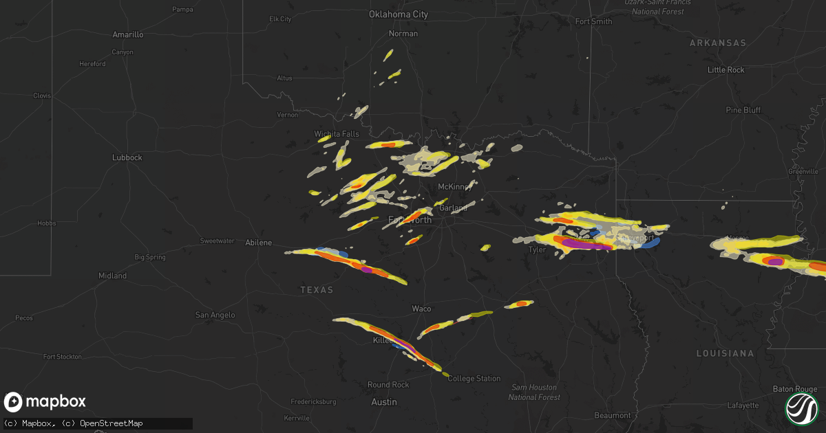
Hail Map on April 2, 2023
Get this storm
April 2 map
$229
one time, instant access
Download today. No call, no setup
Keep the $229
Bought the map and want the full workflow? Apply the entire $229 to a subscription within 7 days. None of it is wasted.
Every map, not just this one
This buys you this map. Subscription and you get every map we run, in the markets you choose from a few cities to whole states to nationwide. Plus real-time alerts the moment a storm fires.
Contact data
Name, contact info, occupancy, even credit band for addresses in the footprint. You go from where it hit to who to call.
Become the source they trust
Unlimited branding weather history reports on demand. You already have the documented answer ready for the property owner, and you are the one who showed up with it.
Property data and RoofTrace estimates
Pull up any address you have got, its value and the exact code rules for that jurisdiction, straight from One Click Code. Then RoofTrace estimates the squares, pitch, and roof value, priced the way you price.
States Impacted by Hail Map on April 2, 2023
Storm reports
Texas
| Date | Description |
|---|---|
| 04/02/20236:59 PM CDT | Report of golf ball size or larger. |
| 04/02/20236:57 PM CDT | Trained spotter report. |
| 04/02/20236:56 PM CDT | Sheriffs office report. |
| 04/02/20236:55 PM CDT | Trees down in marshall. |
| 04/02/20236:55 PM CDT | Public report. |
| 04/02/20236:54 PM CDT | Relayed via email. |
| 04/02/20236:51 PM CDT | Report via social media with pictures. |
| 04/02/20236:51 PM CDT | A local report indicates 1.75 inch wind near 6 WSW HALLSVILLE |
| 04/02/20236:48 PM CDT | Pictures sent via email. |
| 04/02/20236:44 PM CDT | Quarter size hail 3 miles west of sanger. |
| 04/02/20236:38 PM CDT | M-ping report. |
| 04/02/20236:34 PM CDT | A local report indicates 1.00 inch wind near 6 W SPRINGTOWN |
| 04/02/20236:11 PM CDT | Emergency manager reports 1 inch hail in southmayd. |
| 04/02/20236:09 PM CDT | Golf ball size hail reported 5 miles north of hico. |
| 04/02/20235:58 PM CDT | 2 inch hail reported 7 miles north of hico. |
| 04/02/20235:54 PM CDT | Spotter reports 1 inch hail 7 miles nnw hico. |
| 04/02/20235:43 PM CDT | Quarter size hail reported at 377 and alexander rd. |
| 04/02/20235:38 PM CDT | A local report indicates 1.75 inch wind near 4 S STEPHENVILLE |
| 04/02/20235:17 PM CDT | Ping pong ball size hail in desdemona. |
| 04/02/20234:43 PM CDT | 1 inch hail reported in eastland. |
| 04/02/20234:19 PM CDT | Delayed report: quarter size hail reported in plano. |
| 04/02/20234:12 PM CDT | Quarter-size hail in addison. |
| 04/02/20233:54 PM CDT | 1 inch hail reported in colleyville. |
| 04/02/20233:49 PM CDT | Quarter-size hail reported in hurst. |
| 04/02/20233:49 PM CDT | Spotter reports measured 1.5 inch hail in richland hills. |
| 04/02/20233:47 PM CDT | 1 inch hail reported in richland hills north of hwy121. |
| 04/02/20233:46 PM CDT | A local report indicates 1.50 inch wind near 2 E RICHLAND HILLS |
| 04/02/20233:44 PM CDT | Social media report golf ball size hail in haltom city near lower birdville rd. |
| 04/02/20233:43 PM CDT | Nws employee reports ping pong ball size hail just east of downtown fort worth. |
| 04/02/20233:42 PM CDT | 1.25 inch hail just west of downtown fort worth. |
| 04/02/20233:42 PM CDT | Quarter size hail 2 miles west of downtown fort worth. |
| 04/02/20233:40 PM CDT | A local report indicates 1.00 inch wind near 1 NNE FORT WORTH |
| 04/02/20233:40 PM CDT | Quarter size hail in fort worth near i30 and university dr. |
| 04/02/20233:36 PM CDT | Delayed report: social media report of half-dollar size hail in the white lake hills neighborhood. |
| 04/02/20233:36 PM CDT | Em reports golf ball size hail near fm917 and i-35. |
| 04/02/20233:20 PM CDT | Delayed report - quarter size hail in far west fort worth. |
| 04/02/20233:18 PM CDT | Quarter size hail reported near runaway bay. |
| 04/02/20233:15 PM CDT | Social media report of ping pong ball size hail north of 281 and i-20. |
| 04/02/20233:09 PM CDT | Golfball size hail at 380/281. |
| 04/02/20233:00 PM CDT | Half-dollar size hail 9 miles ne of jacksboro. |
| 04/02/20232:42 PM CDT | Quarter size hail reported 6 miles wnw of jacksboro. |
| 04/01/20239:27 PM CDT | Reports of golf ball sized hail |
| 04/01/20239:10 PM CDT | A local report indicates 1.00 inch wind near 6 SW ORE CITY |
| 04/01/20239:03 PM CDT | A local report indicates 1.50 inch wind near 6 ENE GILMER |
| 04/01/20238:53 PM CDT | A local report indicates 1.00 inch wind near 7 S AVINGER |
| 04/01/20238:41 PM CDT | Multiple trees downed near fm 726 and zinnia road. |
| 04/01/20238:27 PM CDT | Social media report of image of several broken tree limbs 3 to 6 inches in diameter. |
| 04/01/20238:25 PM CDT | 1.5 inch hail report from rogers. |
| 04/01/20238:12 PM CDT | 1 inch hail report from little river-acade. |
| 04/01/20238:05 PM CDT | Golf ball size hail near temple. |
| 04/01/20238:00 PM CDT | Delayed report: half-dollar size hail reported near elkhart. |
| 04/01/20237:56 PM CDT | Spotter measured 75 mph wind gust in south belton. |
| 04/01/20237:40 PM CDT | Emergency management reporting quarter size hail. |
| 04/01/20237:32 PM CDT | Reports of trees damage from winds gusting to estimated 50 mph. |
| 04/01/20237:30 PM CDT | Golf ball sized hail fell in elysian fields. |
| 04/01/20237:28 PM CDT | Quarter size hail reported 5 miles southeast of bonham. |
| 04/01/20237:22 PM CDT | Alliance airport |
| 04/01/20237:15 PM CDT | 60-65 mph estimated wind gust near i-35 and 114. |
| 04/01/20237:00 PM CDT | Trees snapped and uprooted. |
Oklahoma
| Date | Description |
|---|---|
| 04/02/20234:43 PM CDT | A local report indicates 1.00 inch wind near 7 SSE ERIN SPRINGS |
Alabama
| Date | Description |
|---|---|
| 04/02/20234:59 AM CDT | Several photos of large hail |
Mississippi
| Date | Description |
|---|---|
| 04/02/20236:10 AM CDT | Report of trees down and fence damage in the community of whistler. Report via social media. |
| 04/02/20235:47 AM CDT | Multiple reports of hail to quarter size in laurel. |
| 04/02/20235:45 AM CDT | An ef1 tornado was confirmed 2 miles ese of moss. The tornado touched down near the intersection of sharon moss rd and pacocean acrs. It traveled ese breaking limbs and |
| 04/02/20235:41 AM CDT | Hail up to half dollar size in rural jones county... North of laurel. |
| 04/02/20234:38 AM CDT | Telephone pole sized pine trees were found down in the yard of a home. Damage possibly due to tornado. |
| 04/02/20234:37 AM CDT | A tornado was confirmed 3 miles south of mendenhall. The tornado began just west of highway 13. Multiple trees were found snapped and uprooted along and cross highway 1 |
| 04/02/20233:58 AM CDT | Hail up to quarter size in crystal springs. |
| 04/02/20233:23 AM CDT | Hail to quarter size in utica. |
| 04/02/202312:40 AM CDT | A trained storm spotter found a large tree down off highway 12. |
Louisiana
| Date | Description |
|---|---|
| 04/01/20239:29 PM CDT | Several trees downed near the intersection of hwy 33 and hwy 822 northeast of ruston... Louisiana. |
| 04/01/20238:55 PM CDT | Several trees downed near and around hwy. 507. |
| 04/01/20238:35 PM CDT | Large tree downed on hwy. 3063 near homer... Louisiana. |
| 04/01/20238:32 PM CDT | Several trees and power lines downed throughout webster parish. Most damage was across the southern third portion of the parish. |
| 04/01/20238:20 PM CDT | Corrects previous tstm wnd dmg report from 9 sse barksdale air force base. Tree downed near the 8500 block of barksdale blvd near taylortown. A vehicle collided with th |
| 04/01/20238:15 PM CDT | Multiple trees downed on sligo road in south bossier. |
| 04/01/20237:52 PM CDT | Trees downed near dillingham ave and mitchell lane in shreveport. |
| 04/01/20237:51 PM CDT | Trees downed near fairview street and line avenue in shreveport. |
| 04/01/20237:50 PM CDT | Tree downed near quinton street... Orla ave and velva ave in shreveport. |
| 04/01/20237:50 PM CDT | Trees down on dixie shreveport road and george road. |
| 04/01/20237:49 PM CDT | A local report indicates 73 MPH wind near 2 SW SHREVEPORT |
| 04/01/20237:49 PM CDT | Tree downed into a kitchen of a home in willow ridge subdivision on the south side of cross lake. |
| 04/01/20237:43 PM CDT | Trees downed near katie circle and pine hill road in the blanchard community. |
| 04/01/20237:42 PM CDT | Trees downed near w phelps avenue... N olney and w warriner ave in the community of blanchard. |
| 04/01/20237:40 PM CDT | Trees down on the north side of blanchard. |
| 04/01/20237:40 PM CDT | Trees downed near old mooringsport-latex road and north hwy. 169 just south of mooringsport. |
Cities Impacted by Hail Map on April 2, 2023
- Holliday, TX
- Graham, TX
- Jacksboro, TX
- Iowa Park, TX
- Wichita Falls, TX
- Perrin, TX
- Chico, TX
- Bowie, TX
- Santo, TX
- Mineral Wells, TX
- Millsap, TX
- Windthorst, TX
- Bridgeport, TX
- Henrietta, TX
- Scotland, TX
- Cleburne, TX
- Joshua, TX
- Alvarado, TX
- Burleson, TX
- Fort Worth, TX
- Haltom City, TX
- Mansfield, TX
- Lillian, TX
- Venus, TX
- Euless, TX
- Hurst, TX
- North Richland Hills, TX
- Bedford, TX
- Colleyville, TX
- Grapevine, TX
- Weatherford, TX
- Whitt, TX
- Graford, TX
- Poolville, TX
- Decatur, TX
- Alvord, TX
- Pilot Point, TX
- Tioga, TX
- Gunter, TX
- Carrollton, TX
- Dallas, TX
- Addison, TX
- Howe, TX
- Cisco, TX
- Rising Star, TX
- Bellevue, TX
- Nocona, TX
- Sherman, TX
- Lott, TX
- Chilton, TX
- Carbon, TX
- Eastland, TX
- Newcastle, TX
- Gorman, TX
- Marlow, OK
- Foster, OK
- Lindsay, OK
- Bradley, OK
- Alex, OK
- Blanchard, OK
- Plano, TX
- Desdemona, TX
- De Leon, TX
- Ranger, TX
- Marlin, TX
- Saint Jo, TX
- Dublin, TX
- Kosse, TX
- Duncan, OK
- Paradise, TX
- Irving, TX
- Springtown, TX
- Justin, TX
- Rhome, TX
- Gainesville, TX
- Era, TX
- Sanger, TX
- Valley View, TX
- Crowley, TX
- Baird, TX
- Walters, OK
- Breckenridge, TX
- Boyd, TX
- Temple, OK
- Palo Pinto, TX
- Olney, TX
- Strawn, TX
- Gordon, TX
- Garland, TX
- Rockwall, TX
- Mesquite, TX
- Rowlett, TX
- Troy, TX
- Temple, TX
- Waurika, OK
- Hastings, OK
- Byers, TX
- Bryson, TX
- Sunset, TX
- Argyle, TX
- Aledo, TX
- Naval Air Station Jrb, TX
- Kemp, TX
- Mabank, TX
- Stephenville, TX
- Muenster, TX
- Van, TX
- Ben Wheeler, TX
- Lindale, TX
- Tyler, TX
- Hico, TX
- Whitesboro, TX
- Groesbeck, TX
- Jewett, TX
- Winona, TX
- Iredell, TX
- Donie, TX
- Buffalo, TX
- Gladewater, TX
- Big Sandy, TX
- Meridian, TX
- Walnut Springs, TX
- Lampasas, TX
- Lometa, TX
- Copperas Cove, TX
- Gatesville, TX
- Oakwood, TX
- Kilgore, TX
- Longview, TX
- White Oak, TX
- Morgan, TX
- Fort Hood, TX
- Henderson, TX
- Tatum, TX
- Hallsville, TX
- Marshall, TX
- Clifton, TX
- Elkhart, TX
- Beckville, TX
- Bonham, TX
- Bailey, TX
- Leonard, TX
- Wolfe City, TX
- Ladonia, TX
- Belton, TX
- De Berry, TX
- Waskom, TX
- Whitney, TX
- Grapeland, TX
- Palestine, TX
- Bethany, LA
- Greenwood, LA
- Shreveport, LA
- Keithville, LA
- Little River Academy, TX
- Bossier City, LA
- Rogers, TX
- Elm Grove, LA
- Doyline, LA
- Haughton, LA
- Ore City, TX
- Gilmer, TX
- Buckholts, TX
- Sibley, LA
- Heflin, LA
- Diana, TX
- Winnsboro, TX
- Lone Star, TX
- Avinger, TX
- Cameron, TX
- Jefferson, TX
- Rockdale, TX
- Milano, TX
- Karnack, TX
- Harleton, TX
- Caldwell, TX
- Vivian, LA
- Oil City, LA
- Hendrix, OK
- Whitewright, TX
- Tom Bean, TX
- Caddo Mills, TX
- Celeste, TX
- Blue Ridge, TX
- Farmersville, TX
- Azle, TX
- Haslet, TX
- Holland, TX
- Ector, TX
- Thornton, TX
- Pottsboro, TX
- Aubrey, TX
- Collinsville, TX
- Marion, LA
- Arp, TX
- Overton, TX
- Goldthwaite, TX
- Ivanhoe, TX
- Telephone, TX
- Trenton, TX
- Sulphur Springs, TX
- Newark, TX
- Grand Prairie, TX
- Pittsburg, TX
- Denison, TX
- Royse City, TX
- Flower Mound, TX
- Brookston, TX
- Paris, TX
- Sumner, TX
- Roanoke, TX
- Hawkins, TX
- Quitman, TX
- Mineola, TX
- South Bend, TX
- Ravenna, TX
- Windom, TX
- Honey Grove, TX
- Savoy, TX
- Bells, TX
- Dodd City, TX
- Mooringsport, LA
- Daingerfield, TX
- Evant, TX
- Nolanville, TX
- Killeen, TX
- Krum, TX
- Lindsay, TX
- Forestburg, TX
- Montague, TX
- Rosston, TX
- Blanchard, LA
- Barksdale Afb, LA
- Belcher, LA
- Benton, LA
- Minden, LA
- Monroe, LA
- Rayville, LA
- Mangham, LA
- Delhi, LA
- Baskin, LA
- Tallulah, LA
- Winnsboro, LA
- Newellton, LA
- West Monroe, LA
- Eros, LA
- Columbia, LA
- Calhoun, LA
- Choudrant, LA
- Princeton, LA
- Vicksburg, MS
- Ruston, LA
- Port Gibson, MS
- Hermanville, MS
- Utica, MS
- Florence, MS
- Braxton, MS
- Crystal Springs, MS
- Edwards, MS
- Terry, MS
- Raymond, MS
- Mendenhall, MS
- Brandon, MS
- Hazlehurst, MS
- Georgetown, MS
- Magee, MS
- Mize, MS
- Mount Olive, MS
- Taylorsville, MS
- Stringer, MS
- Soso, MS
- Laurel, MS
- Heidelberg, MS
- Pinola, MS
- Harrisville, MS
- Frisco City, AL
- Monroeville, AL
- Vredenburgh, AL
- Grove Hill, AL
- Powderly, TX
- Tibbie, AL
- Wagarville, AL
- Yantis, TX
- Como, TX
- Athens, LA
- Alba, TX
- Stonewall, LA
- Dubberly, LA
- Dike, TX
- Gilbert, LA
- Quitman, LA
- Chatham, LA
- Leesburg, TX
- Pickton, TX
- Whatley, AL
- Leroy, AL
- Jackson, AL
- Gainestown, AL
- Collins, MS
- Homer, LA
- Simsboro, LA
- Bienville, LA
- Waynesboro, MS
- Shubuta, MS
- Peterman, AL
- Millry, AL
- Buckatunna, MS
- Evergreen, AL
- Franklin, AL
- Deer Park, AL
- McKenzie, AL