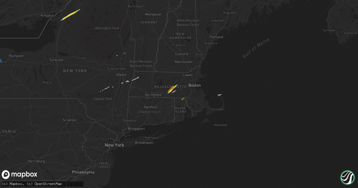
Hail Map in Massachusetts on March 29, 2020
Get this storm
March 29 map
$229
one time, instant access
Download today. No call, no setup
Keep the $229
Bought the map and want the full workflow? Apply the entire $229 to a subscription within 7 days. None of it is wasted.
Every map, not just this one
This buys you this map. Subscription and you get every map we run, in the markets you choose from a few cities to whole states to nationwide. Plus real-time alerts the moment a storm fires.
Contact data
Name, contact info, occupancy, even credit band for addresses in the footprint. You go from where it hit to who to call.
Become the source they trust
Unlimited branding weather history reports on demand. You already have the documented answer ready for the property owner, and you are the one who showed up with it.
Property data and RoofTrace estimates
Pull up any address you have got, its value and the exact code rules for that jurisdiction, straight from One Click Code. Then RoofTrace estimates the squares, pitch, and roof value, priced the way you price.
Storm reports in Massachusetts
Massachusetts
| Date | Description |
|---|---|
| 03/29/20205:13 AM CDT | At 1012 PM EDT, a severe thunderstorm was located over Marion, moving northeast at 55 mph. HAZARD...Quarter size hail. SOURCE...Radar indicated. IMPACT...Minor hail damage to vehicles is possible. Locations impacted include... New Bedford, Plymouth, Marion, Provincetown, Middleborough, Wareham, Sandwich, Bourne, Fairhaven, Carver, Lakeville, Acushnet, Freetown, Mattapoisett, Rochester and Truro. |
| 03/29/20204:52 AM CDT | At 952 PM EDT, a severe thunderstorm was located over Westport, or 7 miles south of Fall River, moving northeast at 55 mph. HAZARD...Quarter size hail. SOURCE...Radar indicated. IMPACT...Minor hail damage to vehicles is possible. Locations impacted include... New Bedford, Fall River, Plymouth, Dartmouth, Marion, Middleborough, Wareham, Portsmouth, Fairhaven, Tiverton, Westport, Carver, Lakeville, Acushnet, Freetown, Mattapoisett, Rochester and Little Compton. |
| 03/29/20203:55 AM CDT | At 854 PM EDT, a severe thunderstorm was located over Shrewsbury, moving northeast at 55 mph. HAZARD...Quarter size hail. SOURCE...Radar indicated. IMPACT...Minor hail damage to vehicles is possible. Locations impacted include... Worcester, Newton, Framingham, Marlborough, Shrewsbury, Chelmsford, Natick, Needham, Milford, Wellesley, Dedham, Westford, Acton, Hudson, Westborough, Grafton, Concord, Sudbury, Holden and Webster. |
| 03/29/20203:47 AM CDT | At 847 PM EDT, a severe thunderstorm was located over Hawley, or 13 miles southeast of North Adams, moving east at 60 mph. HAZARD...Quarter size hail. SOURCE...Radar indicated. IMPACT...Minor hail damage to vehicles is possible. Locations impacted include... Greenfield, Orange, Deerfield, Monroe, Athol, Montague, Sunderland, Northfield, Bernardston, Buckland, Conway, Shelburne, Leverett, Erving, Ashfield, Colrain, Gill, Charlemont, Royalston and Goshen. |
| 03/29/20203:41 AM CDT | At 841 PM EDT, a severe thunderstorm was located near Savoy, or 7 miles south of North Adams, moving east at 65 mph. HAZARD...Quarter size hail. SOURCE...Radar indicated. IMPACT...Damage to vehicles is expected. Locations impacted include... North Adams, Adams, Cheshire, Florida, Savoy, Windsor, Whitcomb Summit, Soldiers Memorial Field, Rusek Whipple Square, Cheshire Harbor, Arnoldville, Renfrew, Savoy Center, Town Crest Village, Brier, Little Egypt, East Renfrew, Maple Grove, Eastern Summit and Zylonite. |
| 03/28/20209:05 PM CDT | A local report indicates 1.00 inch wind near NEW BEDFORD |
| 03/28/20207:56 PM CDT | Amateur radio |
| 03/28/20207:53 PM CDT | Trained spotter |
| 03/28/20207:50 PM CDT | Near the spencer line |
| 03/28/20207:47 PM CDT | A local report indicates 1.00 inch wind near SAVOY |
All States Impacted by Hail Map on March 29, 2020
Cities Impacted by Hail Map on March 29, 2020
- Gansevoort, NY
- Prattsville, NY
- Jewett, NY
- Windham, NY
- Rochdale, MA
- Leicester, MA
- Cherry Valley, MA
- Worcester, MA
- Fort Drum, NY
- Gouverneur, NY
- Evans Mills, NY
- Hermon, NY
- Theresa, NY
- La Fargeville, NY
- Antwerp, NY
- Philadelphia, NY
- West Kill, NY
- Fleischmanns, NY
- North Truro, MA
- Provincetown, MA
- Mirando City, TX
- Laredo, TX
- Oilton, TX
- Valatie, NY
- Kinderhook, NY
- Stuyvesant, NY
- Oxford, MA
- Millbury, MA
- Auburn, MA
- Shrewsbury, MA
- Charlton, MA
- West Boylston, MA
- Spencer, MA
- Boylston, MA
- Porter Corners, NY
- Lancaster, NY
- Cheshire, MA
- Lanesborough, MA
- Pittsfield, MA
- Old Chatham, NY
- East Chatham, NY
- Brainard, NY
- Purling, NY
- Acra, NY
- Round Top, NY
- Cairo, NY
- Hensonville, NY
- Realitos, TX
- Bruni, TX
- Sturbridge, MA
- Holden, MA
- East Brookfield, MA
- Paxton, MA
- North Smithfield, RI
- Cumberland, RI
- Manville, RI
- Woonsocket, RI
- Orchard Park, NY
- Akron, NY
- Alden, NY
- Elba, NY
- Lockport, NY
- Clarence Center, NY
- East Amherst, NY
- Bowmansville, NY
- Darien Center, NY
- Corfu, NY
- Buffalo, NY
- Oakfield, NY
- Batavia, NY
- Basom, NY
- East Pembroke, NY
- Depew, NY
- Clarence, NY
- Elma, NY


