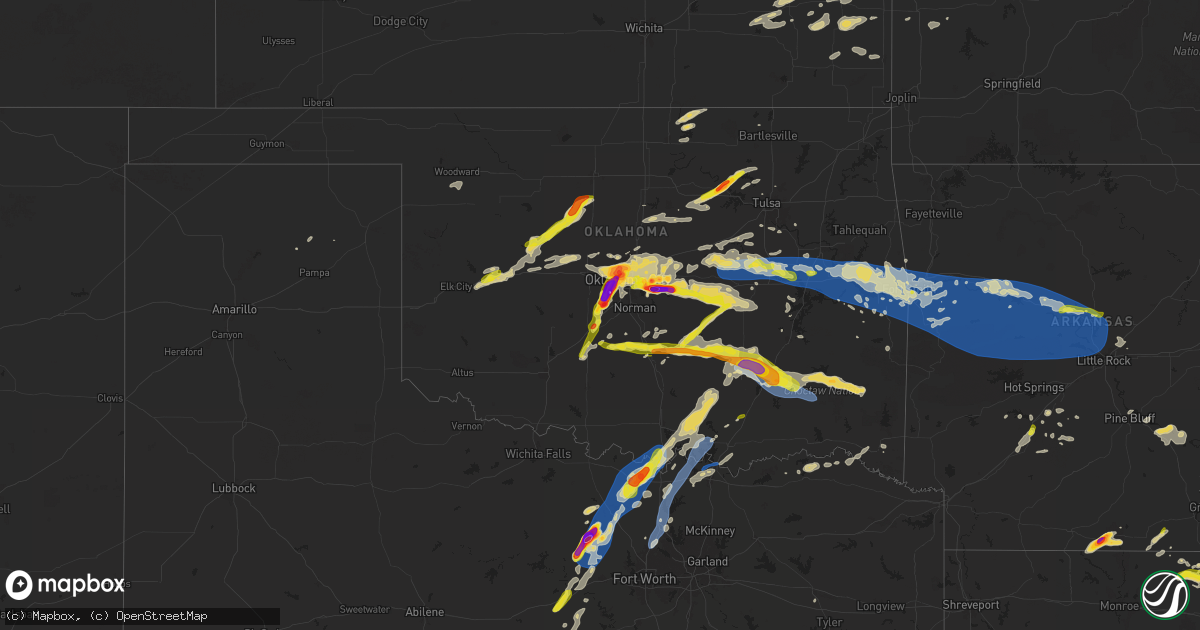
Hail Map on May 17, 2025
Get this storm
May 17 map
$229
one time, instant access
Download today. No call, no setup
Keep the $229
Bought the map and want the full workflow? Apply the entire $229 to a subscription within 7 days. None of it is wasted.
Every map, not just this one
This buys you this map. Subscription and you get every map we run, in the markets you choose from a few cities to whole states to nationwide. Plus real-time alerts the moment a storm fires.
Contact data
Name, contact info, occupancy, even credit band for addresses in the footprint. You go from where it hit to who to call.
Become the source they trust
Unlimited branding weather history reports on demand. You already have the documented answer ready for the property owner, and you are the one who showed up with it.
Property data and RoofTrace estimates
Pull up any address you have got, its value and the exact code rules for that jurisdiction, straight from One Click Code. Then RoofTrace estimates the squares, pitch, and roof value, priced the way you price.
States Impacted by Hail Map on May 17, 2025
Storm reports
Oklahoma
| Date | Description |
|---|---|
| 05/17/20256:50 PM CDT | Report from mping: quarter |
| 05/17/20256:44 PM CDT | Report from mping: quarter |
| 05/17/20255:12 PM CDT | Report from mping: hen egg+ |
| 05/17/20255:11 PM CDT | Report from mping: half dollar |
| 05/17/20255:10 PM CDT | A local report indicates 1.00 inch wind near 5 ENE Tuttle |
| 05/17/20255:05 PM CDT | Report from mping: ping pong ball |
| 05/17/20255:05 PM CDT | Report from mping: hen egg |
| 05/17/20255:05 PM CDT | A local report indicates 1.50 inch wind near 3 NNE Mustang |
| 05/17/20255:05 PM CDT | A local report indicates 1.25 inch wind near 4 SSW Bethany |
| 05/17/20255:04 PM CDT | A local report indicates 1.00 inch wind near 3 NNW Mustang |
| 05/17/20255:04 PM CDT | Report from mping: half dollar |
| 05/17/20255:03 PM CDT | A local report indicates 2.75 inch wind near Mustang |
| 05/17/20255:02 PM CDT | Report from mping: quarter |
| 05/17/20255:02 PM CDT | Report from mping: hen egg+ |
| 05/17/20254:59 PM CDT | Report from mping: half dollar |
| 05/17/20254:56 PM CDT | Report from mping: golf ball |
| 05/17/20254:53 PM CDT | Report from mping: baseball |
| 05/17/20254:50 PM CDT | A local report indicates 1.75 inch wind near 3 ENE Tuttle |
| 05/17/20254:49 PM CDT | Report from mping: half dollar |
| 05/17/20254:48 PM CDT | A local report indicates 1.25 inch wind near 3 SE Bradley |
| 05/17/20254:46 PM CDT | Report from mping: quarter |
| 05/17/20254:45 PM CDT | Report from mping: quarter |
| 05/17/20254:26 PM CDT | A local report indicates 1.00 inch wind near Chickasha |
| 05/17/20254:35 AM CDT | Delayed report of shingles off a roof approximately 8 miles east of spiro. Time estimated from radar. |
| 05/17/20253:55 AM CDT | Delayed report. Trees downed. Time estimated via radar. |
| 05/17/20253:39 AM CDT | A local report indicates 58 MPH wind near 1 WNW Webbers Falls |
| 05/17/20253:22 AM CDT | 55 mph winds also reported. |
| 05/17/20253:03 AM CDT | Hwy 266 & 300 rd; time estimated by radar. |
| 05/17/20252:55 AM CDT | A local report indicates 60 MPH wind near 3 SW Morris |
| 05/17/20252:53 AM CDT | Time estimated by radar. |
| 05/17/20252:50 AM CDT | Multiple trees down on sharp rd between okmulgee and wilson rd intersection sw of town. Time estimated by radar. |
| 05/17/20251:35 AM CDT | Phone call report. |
| 05/17/20251:30 AM CDT | Report from mping: half dollar |
| 05/17/20251:30 AM CDT | Report from mping: quarter |
| 05/16/202511:08 PM CDT | Report from mping: golf ball |
| 05/16/202511:01 PM CDT | A local report indicates 1.75 inch wind near 1 W Cleveland |
| 05/16/202510:59 PM CDT | A local report indicates 1.50 inch wind near 1 W Cleveland |
| 05/16/202510:42 PM CDT | Report from mping: quarter |
| 05/16/202510:35 PM CDT | A local report indicates 2.25 inch wind near 1 SW Dale |
| 05/16/202510:22 PM CDT | Near i-40 and peebly road. |
| 05/16/202510:10 PM CDT | A local report indicates 1.00 inch wind near 5 S Nicoma Park |
| 05/16/20259:58 PM CDT | A local report indicates 1.00 inch wind near 1 NW Tinker Air Force B |
| 05/16/20259:54 PM CDT | A local report indicates 1.00 inch wind near 2 W Tinker Air Force Ba |
| 05/16/20259:54 PM CDT | A local report indicates 1.25 inch wind near 1 W Tinker Air Force Ba |
| 05/16/20259:52 PM CDT | A local report indicates 60 MPH wind near 6 SW Oklahoma City |
| 05/16/20259:51 PM CDT | A local report indicates 1.00 inch wind near 3 SW Tinker Air Force B |
| 05/16/20259:38 PM CDT | Corrects previous tstm wnd gst report from 6 sw oklahoma city. |
| 05/16/20259:33 PM CDT | A local report indicates 1.75 inch wind near 2 S Warr Acres |
| 05/16/20259:30 PM CDT | A local report indicates 1.25 inch wind near 3 S Bethany |
| 05/16/20257:57 PM CDT | A local report indicates 1.75 inch wind near Wardville |
| 05/16/20257:57 PM CDT | A local report indicates 73 MPH wind near Wardville |
| 05/16/20257:55 PM CDT | Report from mping: quarter |
Massachusetts
| Date | Description |
|---|---|
| 05/17/20256:30 PM CDT | Reported tree down on wires on school street and on hill street. |
| 05/17/20256:18 PM CDT | Tree down along the 100 block of maple street in greenfield. Relayed by amateur radio. |
| 05/17/20256:10 PM CDT | Wires and utility pole down on mountain street at laural road. |
| 05/17/20256:07 PM CDT | A local report indicates 1.00 inch wind near 1 SW Williamsburg |
| 05/17/20255:18 PM CDT | Several trees were down along may terrace in pittsfield. |
| 05/17/20255:18 PM CDT | Report of wires down and arching near the intersection of washington mt road and kirchner road. |
| 05/17/20255:17 PM CDT | Tree and wire down along strong avenue in the city of pittsfield. |
| 05/17/20255:17 PM CDT | Several trees were down along may terrace in pittsfield. |
| 05/17/20255:16 PM CDT | Tree and wire down along strong avenue in the city of pittsfield. |
| 05/17/20255:12 PM CDT | Report of wires down and arching near the intersection of washington mt road and kirchner road. |
| 05/17/20255:10 PM CDT | Report of a tree down near may terrace in pittsfield. |
New York
| Date | Description |
|---|---|
| 05/17/20254:54 PM CDT | Tree down on ny 22 northbound between flints crossing road and peaceful valley road. Time estimated from radar. |
| 05/17/20254:32 PM CDT | Report of a tree down near n street rd and street rd. |
| 05/17/20254:22 PM CDT | Numerous trees down around the kinderhook and valatie areas concentrated in the hemlock street and maple lake south vicinity. Time estimated from radar. Possible microb |
| 05/17/20254:20 PM CDT | Report of tree down north of greenwich on rte. 40. |
| 05/17/20254:15 PM CDT | Report of trees and wires down along rte. 40 south of greenwich. |
| 05/17/20253:45 PM CDT | Trees and wires down near the saratoga rv park. |
| 05/17/20253:25 PM CDT | Report of trees and wires down along curtiss rd near salisbury. |
| 05/17/20253:25 PM CDT | Trees down along spruce lake road north of salisbury. |
| 05/17/20252:55 PM CDT | Report passed from wktv in deerfield/utica. |
| 05/17/20252:55 PM CDT | Tree down on property. |
| 05/17/20252:48 PM CDT | Wires down. |
| 05/17/20252:42 PM CDT | A few trees down in the area along with wires and a snapped pole. |
| 05/17/20252:36 PM CDT | Corrects previous hail report from 5 w gansevoort. Report of trees and wires down on corinth mountain rd in wilton. |
| 05/17/20252:36 PM CDT | Report of trees and wires down on corinth mountain rd in wilton. |
| 05/17/20252:20 PM CDT | Report of a tree down along valentine pond rd. Time estimated from radar. |
| 05/17/20252:18 PM CDT | Ledge hill road tree on power lines |
| 05/17/20252:12 PM CDT | Trees down near intersection of turner rd and soper st. |
| 05/17/20252:00 PM CDT | Small tree down on rt 10 lewis wadhams road |
| 05/17/20251:58 PM CDT | Tree on wires in hastings... Ny. |
| 05/17/20251:55 PM CDT | Tree down on power lines. |
| 05/17/20251:41 PM CDT | Tree down on house. |
| 05/17/20251:37 PM CDT | Tree and large branches down at new york state fairgrounds from strong outflow. |
| 05/17/20251:31 PM CDT | Tree down on roof per county dispatch. |
| 05/17/20251:27 PM CDT | Wires down per county dispatch. |
| 05/17/20251:25 PM CDT | Tree uprooted and down onto a house with wires involved per county dispatch. |
| 05/17/20251:17 PM CDT | Trees and wires down on putnam rd. |
| 05/17/20251:17 PM CDT | Trees and wires down on hoyt road. |
| 05/17/20251:17 PM CDT | Trees and wires down on rude st. |
| 05/17/202512:56 PM CDT | Most hail was pea size but a few were as big as quarter size. |
| 05/17/202512:45 PM CDT | Large tree down just south of lyons. Social media report. |
| 05/17/202512:44 PM CDT | Tree and wires down on carter road south of cross road. |
| 05/17/202512:38 PM CDT | Tree blocking gurnee road near ny-31. |
| 05/17/202512:37 PM CDT | Report of tree and wires down on eastside drive in ballston lake. |
| 05/17/202512:27 PM CDT | Tree blocking most of risser road. |
| 05/17/202512:22 PM CDT | Large tree down blocking parce ave. |
| 05/17/202512:20 PM CDT | Report relayed from broadcast media of quarter size hail in glenville. Time estimated from radar. |
| 05/17/202512:12 PM CDT | Several traffic lights blown down along panorama trail. |
| 05/17/202512:10 PM CDT | Power pole broken and lines down on glazer dr. |
| 05/17/202512:10 PM CDT | Large tree down blocking the eastbound lanes of ny route 441. |
| 05/17/202512:05 PM CDT | Very large tree down on crestline dr. |
| 05/17/202511:58 AM CDT | Twitter report. Size estimated from photo. |
| 05/17/202511:54 AM CDT | A local report indicates 1.00 inch wind near Scottsville |
| 05/17/202511:52 AM CDT | Three limbs down on maiden road near ny-390. |
| 05/17/202511:36 AM CDT | Power poles and wires down. |
Pennsylvania
| Date | Description |
|---|---|
| 05/17/20253:53 PM CDT | Several trees and wires down in the south creek township. |
| 05/17/20253:46 PM CDT | Tree down on roadway. |
| 05/17/20253:27 PM CDT | Tree down on roadway. |
Texas
| Date | Description |
|---|---|
| 05/17/20256:50 PM CDT | Half dollar size hail at cr437 and cr408 in cooke county. |
| 05/17/20256:38 PM CDT | Social media picture of golf ball hail in muenster. |
| 05/17/20256:31 PM CDT | Quarter size hail in muenster via em. |
| 05/17/20256:25 PM CDT | 60-65 mph winds estimated on fm922 at montague-cooke county line. Tree damage and items blown around. |
| 05/17/20256:21 PM CDT | Kdto asos 58kt. |
| 05/17/20255:59 PM CDT | Report from mping. |
| 05/17/20255:56 PM CDT | Report from mping. |
| 05/17/20255:53 PM CDT | Baseball size hail just south of runaway bay. |
| 05/17/20255:50 PM CDT | Stormchaser video showed several trees blown down onto hwy 114 between bridgeport and paradise. |
| 05/17/20255:45 PM CDT | Several facebook reports of numerous trees down in and around paradise with some outbuildings damaged. |
| 05/17/20255:42 PM CDT | 70 mph estimated winds in joplin. |
| 05/17/20255:41 PM CDT | Stormchaser photo showed a hail stone approximately 3.25 inches long by 2.5 inches wide fell in joplin. |
| 05/17/20255:41 PM CDT | Roof and awning damage on jefferson st. In whitney. (fw |
| 05/17/20255:41 PM CDT | A local report indicates 0 MPH wind near Whitney |
| 05/17/20255:41 PM CDT | Roof and awning damage on jefferson st. In whitney. |
| 05/17/20255:40 PM CDT | Ping pong ball size hail in joplin. |
| 05/17/20255:40 PM CDT | Trees down in the 100 block of bonita drive. |
| 05/17/20255:36 PM CDT | Quarter size hail at juniper cove marina on lake whitney. |
| 05/17/20255:22 PM CDT | Quarter size hail in mineral wells via social media pictures. |
| 05/17/20254:48 PM CDT | Report from mping: quarter |
| 05/17/20254:48 PM CDT | Repor |
| 05/17/20253:10 PM CDT | Power line down. Inactive. |
| 05/17/20252:55 PM CDT | Quarter size hail. |
| 05/16/20259:00 PM CDT | Trees down on highway 37 just before the red river. |
| 05/16/20258:48 PM CDT | Trees down on fm road 195 in manchester area. |
| 05/16/20258:33 PM CDT | Numerous trees down from the novice community northeastward into red river county. |
| 05/16/20258:33 PM CDT | Nume |
| 05/16/20258:15 PM CDT | Trees down near intersection of hwy 155 and fm road 2685. |
| 05/16/20257:28 PM CDT | Trees down in the hoard community about 1 mile past fm road 1804. Also... Estimated hail up to quarter size. |
| 05/16/20257:27 PM CDT | Many facebook reports of numerous trees down across denison with widespread power outages. |
| 05/16/20257:27 PM CDT | Public reports lots of tree limbs down on country road 431 via social media. |
| 05/16/20257:24 PM CDT | Roof damage at a pharmacy and trees down along fm 120 in pottsboro. |
| 05/16/20257:10 PM CDT | 60 mph winds near and north of whitesboro. Damage along hwy 377 at ferguson rd. |
Arkansas
| Date | Description |
|---|---|
| 05/17/20254:28 PM CDT | Social media report of golf ball size hail about 6 miles east of the town of strong. |
| 05/17/20254:12 PM CDT | Several photos of golf ball to 2 inch hail just to the east and southeast of the town of strong. |
| 05/17/20256:25 AM CDT | Trees down in this area. |
| 05/17/20256:00 AM CDT | A local report indicates 1.00 inch wind near 1 NE Spring Meadows |
| 05/17/20255:45 AM CDT | Trees down in the area. |
| 05/17/20255:45 AM CDT | Trees down in this area. |
| 05/17/20255:20 AM CDT | Trees down and power outages noted west of clarksville. |
| 05/17/20255:20 AM CDT | A local report indicates 75 MPH wind near Scranton |
| 05/17/20255:08 AM CDT | Corrects previous tstm wnd dmg report from 1 nnw paris. Picture shared with a tree blown down partially on top of a home near paris from storms earlier today. |
| 05/17/20255:08 AM CDT | Picture shared with a tree blown down partiallyon top of a home near paris from storms earlier today. |
| 05/17/20255:05 AM CDT | Trees down in this area with estimated max wind gust of 65 mph. |
| 05/17/20254:48 AM CDT | A local report indicates 1.00 inch wind near Lavaca |
| 05/17/20254:42 AM CDT | Signs blown down; intersection of zero st and hwy 45. |
| 05/17/20254:40 AM CDT | Delayed report. Tree damage on shibley road. Photo shared via social media. Time estimated from radar. |
| 05/17/20254:38 AM CDT | Several trees down on highway 96. Time estimated from radar. |
| 05/17/20254:36 AM CDT | Also reported hail just under 1 inch in diameter at phoenix ave. |
| 05/17/20254:32 AM CDT | Corrects previous tstm wnd gst report from 3 wnw barling. Reported at ft smith regional airport. |
| 05/17/20254:31 AM CDT | Report from mping: quarter |
| 05/16/202510:45 PM CDT | Report of a tree down on a house at 440 east 47th st. No injuries were reported. |
| 05/16/20258:36 PM CDT | A local report indicates 1.00 inch wind near 1 E Arkadelphia |
Georgia
| Date | Description |
|---|---|
| 05/17/20258:27 AM CDT | Several trees down along halls bridge road. |
New Hampshire
| Date | Description |
|---|---|
| 05/17/20255:40 PM CDT | Tree down partially obstructing westbound lane of us hwy 4. Time estimated by radar. |
| 05/17/20255:40 PM CDT | Delayed report...multiple trees down on cardigan mountain rd between reagan and eastman rd and close to the canaan raceway; trees were 6-8 inches in diameter. Time esti |
| 05/17/20255:32 PM CDT | Spotter reported quarter size hail near canaan town line. |
| 05/17/20255:28 PM CDT | Spotter reporting half dollar size hail on rt. 4 in enfield. |
| 05/17/20255:25 PM CDT | Trees down blocking nh-120 north bound in the area of methodist hill rd in plainfield. |
| 05/17/20255:25 PM CDT | Trees and branches downed. Pillsbury street partially blocked by 10 inch diameter tree. Time estimated by radar. |
| 05/17/20255:15 PM CDT | Spotter reporting quarter size hail in lebanon. |
| 05/17/20255:15 PM CDT | Spotter reported hail up to ping pong ball size in west lebanon. |
| 05/17/20255:10 PM CDT | Lebanon fire reporting multiple trees down blocking butternut ln. Time estimated by radar. |
| 05/17/20255:10 PM CDT | Trees down on south side of lebanon |
Alabama
| Date | Description |
|---|---|
| 05/17/20256:58 AM CDT | Trees and power lines down along old sylacauga highway. |
| 05/17/20256:54 AM CDT | Photos of large hail shared via social media from broadcast media. |
| 05/17/20256:54 AM CDT | Power lines down along indian shoals road near wilsonville. |
| 05/17/20256:51 AM CDT | Report of 3 trees down |
| 05/17/20256:51 AM CDT | Report of 3 trees down blocking both lanes along bear creek road near crystal lake drive. |
| 05/17/20256:45 AM CDT | Tree down across hig |
| 05/17/20256:45 AM CDT | Tree down across highway 491 bear creek road. |
| 05/17/20256:45 AM CDT | Tree down blocking the road along kinross drive near brook highland trace. |
| 05/17/20256:43 AM CDT | Fire department responding to a report of a tree down near the intersection of brrok highland parkway and brook highland drive. |
| 05/17/20256:43 AM CDT | Trees and power lines down blocking pump house road near caldwell mill road. |
| 05/17/20256:42 AM CDT | Fire department responding to a report of a tree down along highway 11 near sports highland parkway. |
| 05/17/20256:41 AM CDT | Tree down blocking both lanes of travel along highway 36 near willow branch lane. |
| 05/17/20256:38 AM CDT | Tree down blocking grande view parkway near grande view pass... Report that drivers are driving through residents yard to get by. |
| 05/17/20256:38 AM CDT | Vestavia hills fd responding to report of a tree that fell on a home and damaged the front porch. |
| 05/17/20256:38 AM CDT | Power lines down near the intersection of benjamin drive and smokey road in alabaster. |
| 05/17/20256:31 AM CDT | Trained spotter relayed a report from hueytown pd of a tree fell onto a mobile home along west crest estates. |
| 05/17/20256:25 AM CDT | Trained spotter relayed report from hueytown pd near the intersection of murphys lane and greenridge road. |
| 05/17/20256:24 AM CDT | Mccalla fd responding to a report of a tree down on a house along dogwood circle. |
| 05/17/20256:20 AM CDT | Large oak fell on deck and carport. |
| 05/17/20256:14 AM CDT | Report of power lines down near the intersection of old leeds road and cherokee road... Mountain brook fd responding. |
| 05/17/20256:13 AM CDT | Broadcast meteorologist reports multiple trees and power lines down at their family home in the bull city community. |
| 05/17/20256:09 AM CDT | A local report indicates 1.25 inch wind near 1 WSW Indian Springs Vi |
| 05/17/20256:08 AM CDT | Tree fell on a house along with several trees down in the area per trained spotter relaying scanner traffic. |
| 05/17/20256:08 AM CDT | Corrects previous hail report from 3 sw bull city. Numerous trees reported down along lock 17 road according to antioch fd... Report relayed by trained spotter. |
| 05/17/20256:08 AM CDT | Numerous trees reported down along lock 17 road according to antioch fd... Report relayed by trained spotter. |
| 05/17/20256:04 AM CDT | A local report indicates 1.00 inch wind near 2 SSE Lake Cyrus |
| 05/17/20256:02 AM CDT | Public report of quarter size hail via social media. |
| 05/17/20256:02 AM CDT | Broadcast media relayed public photo of hail near hoover. |
Utah
| Date | Description |
|---|---|
| 05/17/20256:15 PM CDT | Vernon hill - 5761 ft |
| 05/17/20255:46 PM CDT | Salt lake city intl airport asos - 4226 ft |
| 05/17/20254:50 PM CDT | Grantsville south - 4630 ft |
| 05/17/20254:25 PM CDT | English village - 4788 ft |
| 05/17/20253:55 PM CDT | Baker lab - 4294 ft |
Arizona
| Date | Description |
|---|---|
| 05/16/202511:33 PM CDT | Peak gust at mesonet station qtwa3 tweeds point. Single gust over 58 mph associated with thunderstorm outflow. |
Wyoming
| Date | Description |
|---|---|
| 05/17/20252:43 PM CDT | Muddy creek - 6970 ft |
Vermont
| Date | Description |
|---|---|
| 05/17/20255:45 PM CDT | One tree uprooted with several snapped near the intersection of rte 9 and woodford state park rd. Time estimated from radar. |
| 05/17/20255:35 PM CDT | Report of a tree down along vt rte 9 and furnace grove rd. |
| 05/17/20255:31 PM CDT | Report of a tree down along rte 7a near the bennington and shaftbury town line. |
| 05/17/20255:12 PM CDT | Trees and powerlines down in the village of hartford |
| 05/17/20255:07 PM CDT | Social media images showing a large tree that fell and destroyed a detached garage. Numerous large trees uprooted. One picture of a tree on powerlines. |
| 05/17/20253:52 PM CDT | Multiple large trees down in plainfield. |
| 05/17/20253:52 PM CDT | Country club rd has tree down and partially washed out |
| 05/17/20253:25 PM CDT | Several trees downed along w jay road. |
| 05/17/20253:06 PM CDT | Two trees snapped in the price chopper parking lot |
| 05/17/20252:47 PM CDT | A local report indicates 1.00 inch wind near Stowe Fork |
| 05/17/20252:42 PM CDT | Smugglers notch state park reports golf ball sized hail |
| 05/17/20252:36 PM CDT | Tree down on reynolds rd. |
| 05/17/20252:24 PM CDT | Tree down on powerlines on gorham ln |
| 05/17/20252:06 PM CDT | An email from the public shows multiple hail stons ranging from 1 to 2 inches in diamater. |
| 05/17/20252:05 PM CDT | A local report indicates 1.25 inch wind near 2 E St. George |
| 05/17/20252:04 PM CDT | A local report indicates 1.00 inch wind near Richmond |
| 05/17/20252:02 PM CDT | 0.5-1.5 inch hail |
| 05/17/20252:00 PM CDT | Nws employee spotted a silo that was knocked over and damaged by strong winds. There was also a large branch that was driven through the roof of a garage. |
| 05/17/20251:50 PM CDT | Tree down near sheehan green with nichel hail |
| 05/17/20251:45 PM CDT | A local report indicates 1.00 inch wind near 1 SW Hinesburg |
| 05/17/20251:41 PM CDT | A local report indicates 1.75 inch wind near Charlotte |
| 05/17/20251:40 PM CDT | A local report indicates 1.75 inch wind near Charlotte |
| 05/17/20258:20 AM CDT | Tree down on berlin pond road |
| 05/17/20258:14 AM CDT | Tree down on berlin pond road. Correction to previous reports event time. |
Mississippi
| Date | Description |
|---|---|
| 05/17/20252:05 PM CDT | Amateur radio operator reported quarter size hail in clinton. |
| 05/17/20251:52 PM CDT | 2.25 in hail measured. |
| 05/17/20255:15 AM CDT | Corrects previous tstm wnd dmg report from new hope. Lowndes ema reports numerous trees and power lines down with some trees on houses. |
| 05/17/20253:18 AM CDT | Trees down on hwy 17. |
| 05/17/20253:10 AM CDT | Trees and powerpoles both snapped near strawberry hill on hwy 82... Near the intersection of county rd 352. Possible tornado. |
| 05/17/20253:10 AM CDT | Trees down on county road 313 in valley hill area. Possible tornado. |
Nevada
| Date | Description |
|---|---|
| 05/16/202510:53 PM CDT | Awos station kvgt north las vegas airport. Wind gust associated with thunderstorm outflow. |
| 05/16/20259:00 PM CDT | Arl sord station 28. Peak gust generated by thunderstorm. |
| 05/16/20258:45 PM CDT | Peak gust at mesonet station a27ab sord station 33. Thunderstorm generated. |
| 05/16/20258:30 PM CDT | Mesonet station a05ab 13.2 n mercury |
| 05/16/20257:45 PM CDT | Mesonet station a05ab 13.2 n mercury |
| 05/16/20257:15 PM CDT | Arl sord area 12 camp. Peak gust generated by thunderstorm. |
Louisiana
| Date | Description |
|---|---|
| 05/17/20254:30 PM CDT | 1 large tree blew down across highway 17... Which blocked traffic and needed to be removed. |
Cities Impacted by Hail Map on May 17, 2025
- Thorsby, AL
- Clanton, AL
- Franklin, GA
- Grantville, GA
- Newnan, GA
- Gouverneur, NY
- Moreland, GA
- Senoia, GA
- Sharpsburg, GA
- Laurens, SC
- Luthersville, GA
- Massena, NY
- Norfolk, NY
- Brasher Falls, NY
- Zebulon, GA
- Williamson, GA
- Griffin, GA
- Barnesville, GA
- Forsyth, GA
- Norwood, NY
- Milner, GA
- Bombay, NY
- Fort Covington, NY
- Holland Patent, NY
- Rome, NY
- Remsen, NY
- Rochester, NY
- Pittsford, NY
- Scottsville, NY
- Caledonia, NY
- Rush, NY
- West Henrietta, NY
- Cold Brook, NY
- Duanesburg, NY
- Schenectady, NY
- Parish, NY
- Pulaski, NY
- Altmar, NY
- Ballston Lake, NY
- Burnt Hills, NY
- Mechanicville, NY
- Williamstown, NY
- Stittville, NY
- Ballston Spa, NY
- Round Lake, NY
- Redford, NY
- Saranac, NY
- Schuyler Falls, NY
- Saratoga Springs, NY
- Edwards, MS
- Vicksburg, MS
- Bolton, MS
- Charlotte, VT
- North Ferrisburgh, VT
- Ferrisburgh, VT
- Shelburne, VT
- Bristol, VT
- Hinesburg, VT
- New Haven, VT
- Clinton, MS
- Raymond, MS
- Jackson, MS
- South Burlington, VT
- Westport, NY
- Essex, NY
- Vergennes, VT
- Williston, VT
- Essex Junction, VT
- Cadyville, NY
- Morrisonville, NY
- Peru, NY
- Richmond, VT
- Huntington, VT
- Byram, MS
- Thendara, NY
- Eagle Bay, NY
- Jericho, VT
- Plattsburgh, NY
- Schroon Lake, NY
- Willsboro, NY
- Adirondack, NY
- Starksboro, VT
- Colchester, VT
- Lohn, TX
- Brady, TX
- Pottersville, NY
- Brant Lake, NY
- Middlebury, VT
- Rochelle, TX
- Mason, TX
- Stowe, VT
- Mullin, TX
- Goldthwaite, TX
- Morrisville, VT
- Hyde Park, VT
- Rockwood, TX
- Santa Anna, TX
- Brookesmith, TX
- Priddy, TX
- Richland Springs, TX
- Northville, NY
- Comanche, TX
- San Saba, TX
- Utica, NY
- Marcy, NY
- Whitesboro, NY
- Flora, MS
- Junction, TX
- Poland, NY
- Barneveld, NY
- Frankfort, NY
- Underhill, VT
- Cambridge, VT
- Waterbury, VT
- Porter Corners, NY
- Art, TX
- Waterbury Center, VT
- Valley Spring, TX
- Pontotoc, TX
- Greenfield Center, NY
- Newport, NY
- Corinth, NY
- Gustine, TX
- Lake Luzerne, NY
- Gansevoort, NY
- Wolcott, VT
- Hamilton, TX
- Richland, MS
- Dublin, TX
- Spearsville, LA
- Evant, TX
- Star, TX
- Marlow, OK
- Rush Springs, OK
- Pottsville, TX
- Carlton, TX
- Voca, TX
- Fredonia, TX
- Madill, OK
- Kingston, OK
- Ninnekah, OK
- Strong, AR
- Huttig, AR
- Fort Edward, NY
- Raleigh, MS
- Stephenville, TX
- Schuylerville, NY
- Chickasha, OK
- Bradley, OK
- Amber, OK
- Pioneer, LA
- Oak Grove, LA
- Lampasas, TX
- Greenwich, NY
- Tuttle, OK
- Lindsay, OK
- Gordon, TX
- Santo, TX
- Pine Hill, AL
- Alex, OK
- Bluff Dale, TX
- Purmela, TX
- Mingus, TX
- Hamburg, AR
- Jonesboro, TX
- Mustang, OK
- Oklahoma City, OK
- Newcastle, OK
- Yukon, OK
- Wheatland, OK
- Blanchard, OK
- Tolar, TX
- Lake Providence, LA
- Lipan, TX
- Woodstock, VT
- Stillwater, NY
- Iredell, TX
- Gatesville, TX
- Bethany, OK
- Maysville, OK
- Paoli, OK
- Wayne, OK
- Pauls Valley, OK
- Morgan, TX
- Meridian, TX
- Quechee, VT
- Hartland, VT
- White River Junction, VT
- Millsap, TX
- Richmond, MA
- Pittsfield, MA
- West Lebanon, NH
- North Hartland, VT
- Taftsville, VT
- Portland, AR
- Walnut Springs, TX
- Mineral Wells, TX
- Schaghticoke, NY
- Perrin, TX
- Graford, TX
- Weatherford, TX
- Whitt, TX
- Byars, OK
- Purcell, OK
- Camden, AL
- Transylvania, LA
- Thetford Center, VT
- South Strafford, VT
- Enfield, NH
- Wilder, VT
- Lebanon, NH
- Hanover, NH
- Hinsdale, MA
- Becket, MA
- Lenox, MA
- Dalton, MA
- Plainfield, NH
- Mayersville, MS
- Rolling Fork, MS
- Poolville, TX
- Jacksboro, TX
- Bridgeport, TX
- Canaan, NH
- Stratford, OK
- Vredenburgh, AL
- Etna, NH
- Lexington, OK
- Grantham, NH
- Pine Apple, AL
- Blum, TX
- Springtown, TX
- Paradise, TX
- Whitney, TX
- Caddo, OK
- Caney, OK
- Chico, TX
- Decatur, TX
- Bonita, LA
- Jones, LA
- Beatrice, AL
- Parkdale, AR
- Hillsboro, TX
- Itasca, TX
- Wanette, OK
- Kopperl, TX
- Abbott, TX
- Aquilla, TX
- Clifton, TX
- Fort Worth, TX
- Keller, TX
- Ada, OK
- Cherokee, TX
- Alvord, TX
- West, TX
- Forestburg, TX
- Roanoke, TX
- Argyle, TX
- Justin, TX
- Georgiana, AL
- Bowie, TX
- Fort Rucker, AL
- Valley Park, MS
- Sunset, TX
- Evergreen, AL
- Muenster, TX
- Saint Jo, TX
- Asher, OK
- Konawa, OK
- Denton, TX
- Ponder, TX
- Sanger, TX
- Aubrey, TX
- Valley View, TX
- Rosston, TX
- Gainesville, TX
- Montague, TX
- Era, TX
- Lindsay, TX
- Nocona, TX
- Thackerville, OK
- Burneyville, OK
- Leon, OK
- Wilmot, AR
- Newton, AL
- Ozark, AL
- Marietta, OK
- Bennett, CO
- Allen, OK
- Stonewall, OK
- Coalgate, OK
- Centrahoma, OK
- Calvin, OK
- Strasburg, CO
- Sasakwa, OK
- Whitesboro, TX
- Stuart, OK
- Collinsville, TX
- Sadler, TX
- Gordonville, TX
- Pottsboro, TX
- Mead, OK
- Wardville, OK
- Sherman, TX
- Denison, TX
- Ardmore, OK
- Lebanon, OK
- Tupelo, OK
- Lindale, TX
- Kiowa, OK
- Atoka, OK
- Pittsburg, OK
- Severy, KS
- Mill Creek, OK
- Mannsville, OK
- Tishomingo, OK
- Calera, OK
- Colbert, OK
- Hendrix, OK
- Kenefic, OK
- Athens, TX
- Stringtown, OK
- Daisy, OK
- Milburn, OK
- Weare, NH
- Okolona, AR
- Gurdon, AR
- Wapanucka, OK
- Sumner, TX
- Antlers, OK
- Yates Center, KS
- Arkadelphia, AR
- Powderly, TX
- Paris, TX
- Clayton, OK
- Sharon, OK
- Wynnewood, OK
- Blossom, TX
- Humboldt, KS
- Woodward, OK
- Detroit, TX
- Coy, AL
- Lafayette, AL
- Maud, OK
- Parker, KS
- Centerville, KS
- Bagwell, TX
- Savonburg, KS
- Elsmore, KS
- Snow, OK
- Nashoba, OK
- Mcalester, OK
- Garvin, OK
- Clarksville, TX
- Red Oak, OK
- Erie, KS
- Moran, KS
- Idabel, OK
- Heavener, OK
- Mccurtain, OK
- Garnett, KS
- Uniontown, KS
- Stark, KS
- Wewoka, OK
- Hepler, KS
- Amity, AR
- Sparkman, AR
- Seiling, OK
- Edmond, OK
- Holdenville, OK
- Neosho Falls, KS
- Guthrie, OK
- Virgil, KS
- Gridley, KS
- Westphalia, KS
- Redfield, KS
- Hartford, KS
- Burlington, KS
- Broken Bow, OK
- Le Roy, KS
- Hodgen, OK
- Fort Scott, KS
- Seminole, OK
- Wetumka, OK
- Choctaw, OK
- Newalla, OK
- Booneville, AR
- Arcadia, OK
- Bethel, OK
- Jones, OK
- Parsons, KS
- Galesburg, KS
- Honobia, OK
- Mansfield, AR
- Toronto, KS
- Luther, OK
- Iola, KS
- Colony, KS
- Saint Paul, KS
- Spencer, OK
- Mcloud, OK
- Shawnee, OK
- La Harpe, KS
- Fall River, KS
- Donaldson, AR
- Brackettville, TX
- Bismarck, AR
- Harrah, OK
- Clinton, OK
- Yale, OK
- Maramec, OK
- Malvern, AR
- Kincaid, KS
- Pawnee, OK
- Stillwater, OK
- Jennings, OK
- Glencoe, OK
- Girard, KS
- Meeker, OK
- McCune, KS
- Watonga, OK
- Thomas, OK
- Foss, OK
- Arapaho, OK
- Earlsboro, OK
- Sheldon, MO
- Cleveland, OK
- Weatherford, OK
- Geary, OK
- Fredonia, KS
- Bronson, KS
- Pittsburg, KS
- Osage, OK
- Hominy, OK
- Newkirk, OK
- Canute, OK
- Corn, OK
- Piqua, KS
- Chanute, KS
- Skiatook, OK
- Barnsdall, OK
- Hitchcock, OK
- Kingfisher, OK
- Loyal, OK
- Hennessey, OK
- Ponca City, OK
- Kaw City, OK
- Okeene, OK
- Waukomis, OK
- Pine Bluff, AR
- Grady, AR
- Carthage, AR
- Shidler, OK
- Leola, AR
- Ames, OK
- Bison, OK
- Calumet, OK
- Laredo, TX
- Walnut, KS
- Coyle, OK
- Burbank, OK
- Orlando, OK
- Mulhall, OK
- White Hall, AR
- Hydro, OK
- Perkins, OK
- Yorktown, AR
- Gould, AR
- Okarche, OK
- Moundville, MO
- Stuttgart, AR
- Milo, MO
- Ripley, OK
- Cushing, OK
- El Dorado Springs, MO
- El Reno, OK
- Gillett, AR
- Piedmont, OK
- Jerico Springs, MO
- Snow Lake, AR
- Glenpool, OK
- Bixby, OK
- Stroud, OK
- Wellston, OK
- Mounds, OK
- Duncan, MS
- Kiefer, OK
- Gunnison, MS
- Merigold, MS
- Mound Bayou, MS
- Rosedale, MS
- Chandler, OK
- Norman, OK
- Broken Arrow, OK
- Coweta, OK
- Sparks, OK
- Bristow, OK
- Kellyville, OK
- Depew, OK
- Doddsville, MS
- Shaw, MS
- Beggs, OK
- Sapulpa, OK
- Cleveland, MS
- Boyle, MS
- Prague, OK
- Paden, OK
- Ruleville, MS
- Minter City, MS
- Castle, OK
- Drew, MS
- Okemah, OK
- Schlater, MS
- Indianola, MS
- Sunflower, MS
- Okmulgee, OK
- Boley, OK
- Henryetta, OK
- Greenwood, MS
- Philipp, MS
- Council Hill, OK
- Carrollton, MS
- Moorhead, MS
- Morris, OK
- Boynton, OK
- Sidon, MS
- Weleetka, OK
- Muskogee, OK
- Coila, MS
- Oktaha, OK
- Checotah, OK
- Warner, OK
- Gore, OK
- Webbers Falls, OK
- Winona, MS
- McCarley, MS
- Dustin, OK
- Vian, OK
- Stigler, OK
- Porum, OK
- Eufaula, OK
- Hanna, OK
- Uniontown, AR
- Sallisaw, OK
- Gans, OK
- Indianola, OK
- Muldrow, OK
- Keota, OK
- Bokoshe, OK
- Spiro, OK
- Shady Point, OK
- Roland, OK
- Pocola, OK
- Alma, AR
- Van Buren, AR
- Fort Smith, AR
- Poteau, OK
- Natural Dam, AR
- Arkoma, OK
- Greenwood, AR
- Haskell, OK
- Starkville, MS
- Lavaca, AR
- Charleston, AR
- West Point, MS
- Magazine, AR
- Huntington, AR
- Whitefield, OK
- Barling, AR
- Aberdeen, MS
- Ozark, AR
- Paris, AR
- Branch, AR
- Cecil, AR
- Columbus, MS
- Ethelsville, AL
- Brookwood, AL
- Scranton, AR
- Hartman, AR
- Coal Hill, AR
- Lamar, AR
- New Blaine, AR
- Clarksville, AR
- Prue, OK
- McCalla, AL
- Vance, AL
- Reform, AL
- Millport, AL
- Knoxville, AR
- London, AR
- Delaware, AR
- Atkins, AR
- Russellville, AR
- Pottsville, AR
- Morrilton, AR
- Coker, AL
- Northport, AL
- Buhl, AL
- Dover, AR
- Bessemer, AL
- Elrod, AL
- Sperry, OK
- Gordo, AL
- Birmingham, AL
- Alabaster, AL
- Tuscaloosa, AL
- Calera, AL
- Plumerville, AR
- Hattieville, AR
- Tulsa, OK
- Helena, AL
- Pelham, AL
- Chelsea, AL
- Wilsonville, AL
- Columbiana, AL
- Greenbrier, AR
- Sylacauga, AL
- Shelby, AL
- Mount Olive, AL
- Goodwater, AL
- Weogufka, AL
- Adger, AL
- Conway, AR
- Sterrett, AL
- Owasso, OK
- Subiaco, AR
- Blue Mountain, AR
- Havana, AR
- Waldron, AR
- Ratcliff, AR
- Altus, AR
- Belleville, AR
- Dardanelle, AR
- Hector, AR
- Danville, AR
- Perryville, AR
- Briggsville, AR
- Harvey, AR
- Bluffton, AR
- Gravelly, AR
- Ola, AR
- Casa, AR
- Plainview, AR
- Rover, AR
- Springfield, AR
- Solgohachia, AR
- Adona, AR
- Vilonia, AR
- Jerusalem, AR
- Mayflower, AR
- Perry, AR
- Bigelow, AR
- Houston, AR
- Wooster, AR
- Maumelle, AR
- Roland, AR
- Paron, AR
- North Little Rock, AR
- Little Rock, AR
- Benton, AR
- Hot Springs Village, AR
- Alexander, AR
- Dolomite, AL
- Echola, AL
- West Blocton, AL
- Woodstock, AL
- Cottondale, AL
- Pleasant Grove, AL
- Fairfield, AL
- Brierfield, AL
- Montevallo, AL
- Harpersville, AL
- Childersburg, AL
- Vincent, AL
- Gardendale, AL
- Jacksonville, AR
- Sherwood, AR
- Vandiver, AL
- Leeds, AL
- Chester, AR
- Dyer, AR
- Stilwell, OK
- Mountainburg, AR
- Mulberry, AR
- Rudy, AR
- Cedarville, AR
- Hackett, AR
- Cameron, OK
- Bunch, OK
- Braggs, OK
- Midland, AR
- Hartford, AR
- Jessieville, AR
- Little Rock Air Force Base, AR
- Cabot, AR
- Ragland, AL
- Ohatchee, AL
- Ashland, AL
- Talladega, AL
- Alpine, AL
- Cropwell, AL